Embed Size (px)
Citation preview
spe 415-05 page 61
61
Geological Society of AmericaSpecial Paper 415
2006
Applications of morphochronology to the active tectonics of Tibet
Frederick J. RyersonInstitute of Geophysics and Planetary Physics, Lawrence Livermore National Laboratory, Livermore, 94550 California, USA
Paul TapponnierLaboratoire de Tectonique, Mécanique de la Lithosphère, UMR7578, CNRS, Institut de Physique du Globe de Paris,
75252 Paris cedex 05, France
Robert C. FinkelCenter for Accelerator Mass Spectrometry, Lawrence Livermore National Laboratory, Livermore, 94550 California, USA
Anne-Sophie MériauxInstitute of Geophysics and Planetary Physics, Lawrence Livermore National Laboratory, Livermore, 94550 California, USA
Jérôme Van der WoerdInstitut de Physique du Globe de Strasbourg, CNRS-UMR 7516, Strasbourg, France
Cécile LasserreDépartement Terre Atmosphère Océan, École Normale Supérieure, 24, rue Lhomond, 75231 Paris cedex 05, France
Marie-Luce ChevalierLaboratoire de Tectonique, Mécanique de la Lithosphère, UMR7578, CNRS, Institut de Physique du Globe de Paris,
75252 Paris cedex 05, France, and Institute of Geophysics and Planetary Physics, Lawrence Livermore National Laboratory, Livermore, 94550 California, USA
Xi-wei XuInstitute of Geology, China Earthquake Administration, Beijing 100029, People’s Republic of China
Hai-bing LiLaboratory of Continental Dynamics, Institute of Geology, Chinese Academy of Geological Sciences, Beijing 100037,
People’s Republic of China
Geoffrey C.P. KingLaboratoire de Tectonique, Mécanique de la Lithosphère, UMR7578, CNRS, Institut de Physique du Globe de Paris,
75252 Paris cedex 05, France
ABSTRACT
The Himalayas and the Tibetan Plateau were formed as a result of the collision of India and Asia, and provide an excellent opportunity to study the mechanical response
Ryerson, F.J., Tapponnier, P., Finkel, R.C., Mériaux, A.-S., Van der Woerd, J., Lasserre, C., Chevalier, M.-L., Xu, X., Li, H., and King, G.C.P., 2006, Applications of morphochronology to the active tectonics of Tibet, in Siame, L.L., Bourlès, D.L., and Brown, E.T., eds., Application of cosmogenic nuclides to the study of Earth surface processes: The practice and the potential: Geological Society of America Special Paper 415, p. 61–86, doi: 10.1130/2006.2415(05). For permission to copy, contact [email protected]. © 2006 Geological Society of America. All rights reserved.
62 Ryerson et al.
spe 415-05 page 62
INTRODUCTION
With the exception of the ocean basins, the Tibetan Plateau is among the most prominent physiographic features on the sur-face of Earth, with an area equivalent to ~2/3 that of the con-terminous United States and an average elevation of ~5000 m. Much as the study of the ocean basins helped to provide the fundamental constraints on global tectonics and the rheology of the oceanic lithosphere, the evolution of Tibet provides a similar opportunity to constrain the mechanical behavior of the conti-nental lithosphere and the effects of plate tectonics within the continental regime. The ongoing Indo-Asian collision provides an opportunity to investigate the evolution of tectonic features within and around the collision zone over a period from ca. 50–55 Ma to the present. As the current manifestation of Indo-Asian convergence, active tectonic processes form an important com-ponent of the long-term tectonic evolution of Asia. The rates of such processes, such as slip on major, active strike-slip faults or uplift along thrust systems, are critical to assessing how ongo-ing convergence is accommodated. If indeed “the present is the
key to the past,” the rates of active processes and the inferred deformation mechanisms should inform our understanding of the long-term tectonic evolution of central Asia.
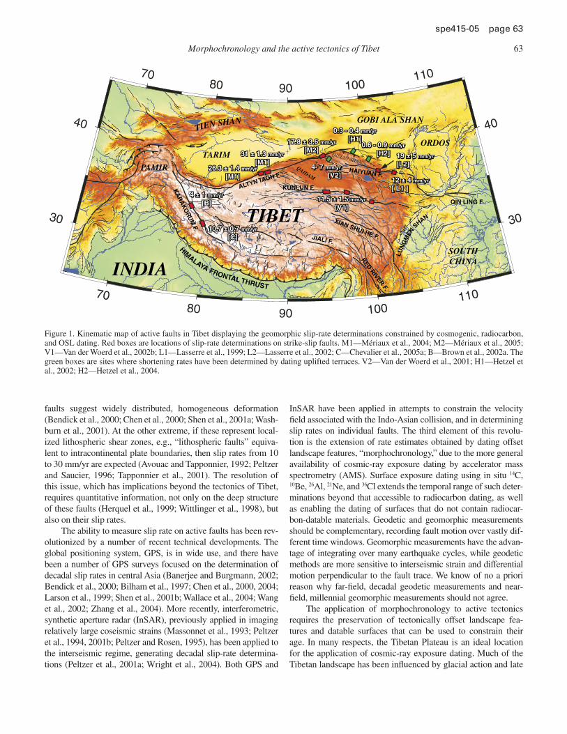
One of the central debates involving the evolution of the Tibetan Plateau concerns whether the deformation of the con-tinental lithosphere is homogeneously distributed or localized along the boundaries of blocks undergoing little internal defor-mation. The latter is consistent with the basic tenets of plate tec-tonics, e.g., rigid lithospheric plates, while the former implies that the rheology of the continental and oceanic lithosphere may be fundamentally different, with the continents deforming more like fl uids (Avouac and Tapponnier, 1993; England and Houseman, 1986; England and Molnar, 1997a, 1997b; Peltzer and Saucier, 1996; Peltzer and Tapponnier, 1988). These end-member models make very different predictions regarding the rates of slip on the large strike-slip faults, such as the Altyn Tagh, Karakorum, Kun-lun, and Haiyuan faults that defi ne much of the boundary of the Tibetan Plateau (Fig. 1). Viewed as a by-product of distributed deformation in the lower crust and continental lithosphere, rela-tively low rates of slip (<1 cm/yr) on these bounding strike-slip
of the continental lithosphere to tectonic stress. Geophysicists are divided in their views on the nature of this response, advocating either (1) homogeneously distributed deformation with the lithosphere deforming as a fl uid continuum or (2) highly local-ized deformation with the lithosphere deforming as a system of blocks. The resolution of this issue has broad implications for understanding the tectonic response of con-tinental lithosphere in general. Homogeneous deformation is supported by relatively low decadal, geodetic slip-rate estimates for the Altyn Tagh and Karakorum faults. Localized deformation is supported by high millennial, geomorphic slip rates con-strained by both cosmogenic and radiocarbon dating on these faults. Based upon the agreement of rates determined by radiocarbon and cosmogenic dating, the overall linearity of offset versus age correlations, and the plateau-wide correlation of land-scape evolution and climate history, the disparity between geomorphic and geodetic slip-rate determinations is unlikely to be due to the effects of surface erosion on the cosmogenic age determinations. Similarly, based upon the consistency of slip rates over various observation intervals, secular variations in slip rate appear to persist no longer than 2000 yr and are unlikely to provide reconciliation. Conversely, geodetic and geomorphic slip-rate estimates on the Kunlun fault, which does not have signifi -cant splays or associated thrust faults, are in good agreement, indicating that there is no fundamental reason why these complementary geodetic and geomorphic methods should disagree. Similarly, the geodetic and geomorphic estimates of shortening rates across the northeastern edge of the plateau are in reasonable agreement, and the geo-morphic rates on individual thrust faults demonstrate a signifi cant eastward decrease in the shortening rate. This rate decrease is consistent with the transfer of slip from the Altyn Tagh fault to genetically related thrust mountain building at its terminus. Rates on the Altyn Tagh fault suggest a similar decrease in rate, but the current data set is too small to be defi nitive. Overall, the high, late Pleistocene–Holocene geomor-phic slip velocities on the major strike-slip faults of Tibet suggest that these faults absorb as much of India’s convergence relative to Siberia as the Himalayan Main Frontal Thrust on the southern edge of the plateau.
Keywords: deformation, active faults, Tibetan Plateau, continental deformation, cos-mogenic nuclides
Morphochronology and the active tectonics of Tibet 63
spe 415-05 page 63
faults suggest widely distributed, homogeneous deformation (Bendick et al., 2000; Chen et al., 2000; Shen et al., 2001a; Wash-burn et al., 2001). At the other extreme, if these represent local-ized lithospheric shear zones, e.g., “lithospheric faults” equiva-lent to intracontinental plate boundaries, then slip rates from 10 to 30 mm/yr are expected (Avouac and Tapponnier, 1992; Peltzer and Saucier, 1996; Tapponnier et al., 2001). The resolution of this issue, which has implications beyond the tectonics of Tibet, requires quantitative information, not only on the deep structure of these faults (Herquel et al., 1999; Wittlinger et al., 1998), but also on their slip rates.
The ability to measure slip rate on active faults has been rev-olutionized by a number of recent technical developments. The global positioning system, GPS, is in wide use, and there have been a number of GPS surveys focused on the determination of decadal slip rates in central Asia (Banerjee and Burgmann, 2002; Bendick et al., 2000; Bilham et al., 1997; Chen et al., 2000, 2004; Larson et al., 1999; Shen et al., 2001b; Wallace et al., 2004; Wang et al., 2002; Zhang et al., 2004). More recently, interferometric, synthetic aperture radar (InSAR), previously applied in imaging relatively large coseismic strains (Massonnet et al., 1993; Peltzer et al., 1994, 2001b; Peltzer and Rosen, 1995), has been applied to the interseismic regime, generating decadal slip-rate determina-tions (Peltzer et al., 2001a; Wright et al., 2004). Both GPS and
InSAR have been applied in attempts to constrain the velocity fi eld associated with the Indo-Asian collision, and in determining slip rates on individual faults. The third element of this revolu-tion is the extension of rate estimates obtained by dating offset landscape features, “morphochronology,” due to the more general availability of cosmic-ray exposure dating by accelerator mass spectrometry (AMS). Surface exposure dating using in situ 14C, 10Be, 26Al, 21Ne, and 36Cl extends the temporal range of such deter-minations beyond that accessible to radiocarbon dating, as well as enabling the dating of surfaces that do not contain radiocar-bon-datable materials. Geodetic and geomorphic measurements should be complementary, recording fault motion over vastly dif-ferent time windows. Geomorphic measurements have the advan-tage of integrating over many earthquake cycles, while geodetic methods are more sensitive to interseismic strain and differential motion perpendicular to the fault trace. We know of no a priori reason why far-fi eld, decadal geodetic measurements and near-fi eld, millennial geomorphic measurements should not agree.
The application of morphochronology to active tectonics requires the preservation of tectonically offset landscape fea-tures and datable surfaces that can be used to constrain their age. In many respects, the Tibetan Plateau is an ideal location for the application of cosmic-ray exposure dating. Much of the Tibetan landscape has been infl uenced by glacial action and late
70
70
80
80
90
90
100
100
110
110
30 30
40 40
26.3 ± 1.4 26.3 ± 1.4 mm/yrmm/yr
[M1][M1]
4 ± 1 4 ± 1 mm/yrmm/yr
[B][B]
10.7 ± 0.7 10.7 ± 0.7 mm/yrmm/yr
[C][C]
11.5 ± 1.5 11.5 ± 1.5 mm/yrmm/yr
[V1][V1]
31 ± 1.3 31 ± 1.3 mm/yrmm/yr
[M1][M1]
17.8 ± 3.6 17.8 ± 3.6 mm/yrmm/yr
[M2][M2]
0.3 - 0.4 0.3 - 0.4 mm/yrmm/yr
[H1][H1]
4- 7 mm/yr
[V2]12 ± 4 12 ± 4 mm/yrmm/yr
[ L1 ][ L1 ]
19 ± 5 19 ± 5 mm/yrmm/yr
[L2][L2]26.3 ± 1.4 mm/yr
[M1]
4 ± 1 mm/yr
[B]
10.7 ± 0.7 mm/yr
[C]
11.5 ± 1.5 mm/yr
[V1]
31 ± 1.3 mm/yr
[M1]
17.8 ± 3.6 mm/yr
[M2]
0.3 - 0.4 mm/yr
[H1]
4- 7 mm/yr
[V2]12 ± 4 mm/yr
[ L1 ]
19 ± 5 mm/yr
[L2]
0.6 - 0.9 0.6 - 0.9 mm/yrmm/yr
[H2][H2]0.6 - 0.9 mm/yr
[H2]TARIM
TIBET
INDIA
GOBI ALA SHAN
ORDOS
SOUTHCHINA
PAMIR
TIEN SHAN
QAIDAM
JIALI F.
RED
RIV
ER
F.
XIAN SHUI HE F.
KUNLUN F.ALTYN TAGH F.HAIYUAN F.
QIN LING F.
KA
RA
KO
RU
M F.
HIMALAYA FRONTAL THRUST
LUN
GM
EN S
HAN
QILIAN SHAN
Karakax Valley
Figure 1. Kinematic map of active faults in Tibet displaying the geomorphic slip-rate determinations constrained by cosmogenic, radiocarbon, and OSL dating. Red boxes are locations of slip-rate determinations on strike-slip faults. M1—Mériaux et al., 2004; M2—Mériaux et al., 2005; V1—Van der Woerd et al., 2002b; L1—Lasserre et al., 1999; L2—Lasserre et al., 2002; C—Chevalier et al., 2005a; B—Brown et al., 2002a. The green boxes are sites where shortening rates have been determined by dating uplifted terraces. V2—Van der Woerd et al., 2001; H1—Hetzel et al., 2002; H2—Hetzel et al., 2004.
64 Ryerson et al.
spe 415-05 page 64
Pleistocene climate change, and locations can be found where glacial features such as moraines and glacial valleys have been tectonically offset. In other areas, climate change has modulated fl uvial processes resulting in the deposition of alluvial fans and in the deposition and incision of fl uvial terraces. These features serve as temporal markers whose offset can be used to indicate the rate of tectonic deformation. The relatively arid climate of the plateau has allowed many of these features to be preserved, recording offsets as old as ca. 250,000 yr B.P. (Chevalier et al., 2005a). In addition, due to its high elevation, Tibet is an ideal location for the application of cosmogenic dating, as the produc-tion rates here are as high as any on the planet, allowing both smaller and younger samples to be dated with usable precision.
In this paper, we will review the assumptions and methods employed in recent efforts to constrain the rates of motion along some of the major faults in Asia by cosmogenic dating, as well as address some of the criticisms that have been leveled at this method. We will focus on the large-scale spatial variation in mil-lennial slip rates across the plateau and along its boundaries, comparing these with various kinematic models of Indo-Asian deformation. Of particular interest is the variation in slip rate along the northeastern boundary of the plateau where uplift on active thrusts has been linked to slip along the major strike-slip faults (Meyer et al., 1998). The genetic link between the east-ward extrusion of central Tibet and uplift along the northeastern boundary prescribes and eastward decrease in strike-slip velocity that should be quantitatively refl ected in uplift rates. Where pos-sible, we will compare these rate estimates obtained by cosmo-genic dating with those from (1) radiocarbon dating, (2) geodetic methods, and (3) Cenozoic geologic rates.
DEVELOPMENT OF GEOMORPHIC OFFSETS AND COSMOGENIC DATING OF DEPOSITIONAL SURFACES
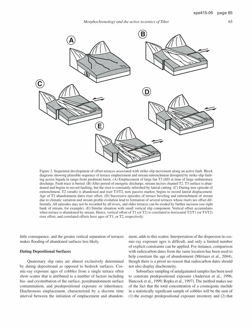
Using geomorphic offsets to determine slip rates on active faults requires the creation of datable landscape features that are then passively preserved (Sieh and Jahns, 1984; Weldon and Sieh, 1985). The interpretational framework for determining slip rates on strike-slip faults based on the lateral displacement of ter-race risers and fl uvial channels is illustrated in Figure 2. Here an alluvial surface, T3, deposited atop an active strike-slip fault is subsequently incised, and a younger terrace, T2, is emplaced along the active stream. Ideally, the resulting T3/T2 riser would be continually refreshed by fl uvial activity on T2. The T3/T2 riser becomes a passive offset marker only when T2 is abandoned due to a new episode of incision, which in turn leads to the forma-tion of the underlying T1 terrace and the T2/T1 riser. Renewed incision indicates that the threshold between aggradation and degradation has been crossed, a condition that may be driven by climate-related variations in sediment load and/or precipita-tion rate. While the time at which the aggradation/degradation threshold is reached at a given point along a river may vary (Bull, 1991), terrace abandonment at a particular point should represent
a discrete temporal event. The displacements recorded by terrace risers are necessarily minimum displacements, as they may be reworked by subsequent fl uvial erosion. For instance, fl ooding by the stream occupying T1 could cause it to temporarily reoccupy T2. This could result in lateral erosion of the T3/T2 riser, reduc-ing the observed offset.
The abandonment age of a terrace is typically defi ned by its youngest surface exposure age and/or the radiocarbon dates obtained from the shallowest subsurface sample (cf. Mériaux et al., 2004). Coupling the abandonment of T2 with the overly-ing T3/T2 offset yields a maximum estimate of the slip rate, the “strath abandonment model” age (Mériaux et al., 2005), and is relevant to a scenario in which occupation of a terrace level is of short duration and no riser offset is accumulated prior to aban-donment. In the case where a strath terrace has been occupied by a stream system for a period that is long relative to earthquake recurrence, and some permanent riser offset is accumulated prior to abandonment, the offset should be linked with the onset of emplacement of the surface underlying the riser. This may be the case for surfaces constructed by high-energy, ephemeral braided streams where deposition is likely diachronous. In such instances, the emplacement age can be approximated by the oldest expo-sure age in the surface age distribution. This “strath emplacement model” yields a minimum estimate of the slip rate.
Both “strath” models link the age of the riser to the age of the underlying terrace, but use different extremes in the age distribu-tion to estimate the slip rate. An absolute lower bound on the slip rate is obtained by combining an offset with the abandonment age of the overlying terrace. This “fi ll-channel model” is appropriate when the strath terrace underlying the riser of interest is fl ooded after abandonment and buried by new “fi ll” deposits that yield an erroneously young age for the riser offset. However, as the riser cannot be older than the terrace into which it is incised, the aban-donment age of the upper terrace yields an absolute minimum approximation of the slip rate. The appropriateness of “strath” as opposed to “fi ll” approximations is based upon the geomorphic characterization of the terraces in the fi eld. The “fi ll” approxima-tion is useful in determining an absolute minimum rate regardless of the nature of the terraces, and is more generally useful in deter-mining rates from stream channel offsets, as a stream channel cannot predate the surface it incises.
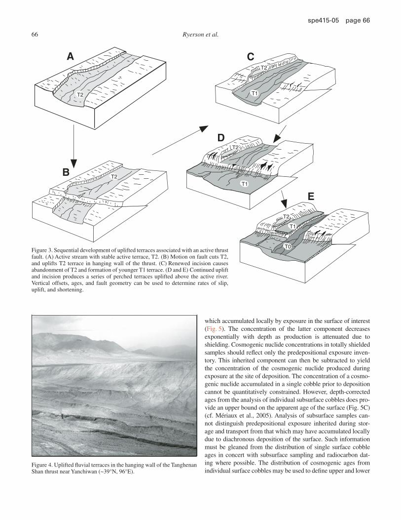
Fluvial terraces can also be used to determine vertical uplift rates when a normal or thrust fault displaces active stream ter-races (Fig. 3) (for normal faults see Avouac and Peltzer, 1993). Here tectonic activity uplifts the terraces in the hanging wall of the thrust, producing a disequilibrium stream gradient that the fl uvial system seeks to eliminate by renewed incision. Contin-ued uplift and incision can produce a series of uplifted terraces perched above an active river such as those found in the hang-ing walls of the Tanghenan Shan thrusts near Yanchiwan (Fig. 4). Again, dating of the perched surfaces can be combined with ver-tical offsets and fault geometry to obtain uplift and convergence rates (cf. Hetzel et al., 2002, 2004; Van der Woerd et al., 2001). In this case, the distinction between strath or fi ll terraces is of
Morphochronology and the active tectonics of Tibet 65
spe 415-05 page 65
little consequence, and the greater vertical separation of terraces makes fl ooding of abandoned surfaces less likely.
Dating Depositional Surfaces
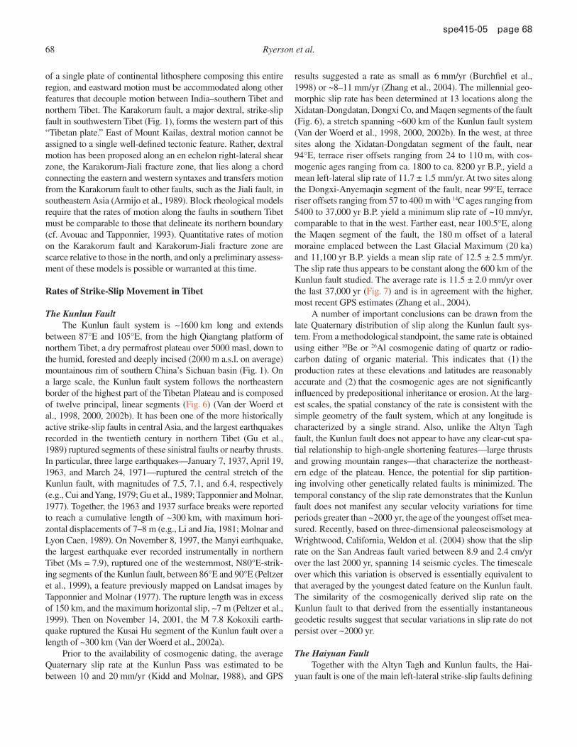
Quaternary slip rates are almost exclusively determined by dating depositional as opposed to bedrock surfaces. Cos-mic-ray exposure ages of cobbles from a single terrace often show scatter that is attributed to a number of factors including bio- and cryoturbation of the surface, postabandonment surface contamination, and predepositional exposure or inheritance. Diachronous emplacement, characterized by a discrete time interval between the initiation of emplacement and abandon-
ment, adds to this scatter. Interpretation of the dispersion in cos-mic-ray exposure ages is diffi cult, and only a limited number of explicit constraints can be applied. For instance, comparison with radiocarbon dates from the same location has been used to help constrain the age of abandonment (Mériaux et al., 2004), though there is a priori no reason that radiocarbon dates should not also display diachroneity.
Subsurface sampling of amalgamated samples has been used to constrain predepositional exposure (Anderson et al., 1996; Hancock et al., 1999; Repka et al., 1997). The method makes use of the fact that the total concentration of a cosmogenic nuclide in a statistically signifi cant sample of cobbles will be the sum of (1) the average predepositional exposure inventory and (2) that
+
CD
BA
T3
T3
T3
T3
T2
T2
T2
T1
T1T0
E
T3T2
T1T0
Figure 2. Sequential development of offset terraces associated with strike-slip movement along an active fault. Block diagrams showing plausible sequence of terrace emplacement and stream entrenchment disrupted by strike-slip fault-ing across bajada in range-front piedmont basin. (A) Emplacement of large fan T3 (fi ll) at time of large sedimentary discharge. Fault trace is buried. (B) After period of energetic discharge, stream incises channel T2. T3 surface is aban-doned and begins to record faulting, but the riser is constantly refreshed by lateral cutting. (C) During new episode of entrenchment, T2 (strath) is abandoned and riser T3/T2, now passive marker, begins to record lateral displacement. Age of T2 abandonment dates riser offset. (D) Successive episodes of terrace beveling and entrenchment of stream due to climatic variation and stream profi le evolution lead to formation of several terraces whose risers are offset dif-ferently. All episodes may not be recorded by all rivers, and older terraces can be eroded by further incision (see right bank of stream, for example). (E) Similar situation with small vertical slip component. Vertical offset accumulates when terrace is abandoned by stream. Hence, vertical offset of T1 (or T2) is correlated to horizontal T2/T1 (or T3/T2) riser offset, and correlated offsets have ages of T1, or T2, respectively.
66 Ryerson et al.
spe 415-05 page 66
which accumulated locally by exposure in the surface of interest (Fig. 5). The concentration of the latter component decreases exponentially with depth as production is attenuated due to shielding. Cosmogenic nuclide concentrations in totally shielded samples should refl ect only the predepositional exposure inven-tory. This inherited component can then be subtracted to yield the concentration of the cosmogenic nuclide produced during exposure at the site of deposition. The concentration of a cosmo-genic nuclide accumulated in a single cobble prior to deposition cannot be quantitatively constrained. However, depth-corrected ages from the analysis of individual subsurface cobbles does pro-vide an upper bound on the apparent age of the surface (Fig. 5C) (cf. Mériaux et al., 2005). Analysis of subsurface samples can-not distinguish predepositional exposure inherited during stor-age and transport from that which may have accumulated locally due to diachronous deposition of the surface. Such information must be gleaned from the distribution of single surface cobble ages in concert with subsurface sampling and radiocarbon dat-ing where possible. The distribution of cosmogenic ages from individual surface cobbles may be used to defi ne upper and lower
A
B
C
D
E
T2
T2T1
T1
T1
T0
T2
T2
T2
Figure 3. Sequential development of uplifted terraces associated with an active thrust fault. (A) Active stream with stable active terrace, T2. (B) Motion on fault cuts T2, and uplifts T2 terrace in hanging wall of the thrust. (C) Renewed incision causes abandonment of T2 and formation of younger T1 terrace. (D and E) Continued uplift and incision produces a series of perched terraces uplifted above the active river. Vertical offsets, ages, and fault geometry can be used to determine rates of slip, uplift, and shortening.
Figure 4. Uplifted fl uvial terraces in the hanging wall of the Tanghenan Shan thrust near Yanchiwan (~39°N, 96°E).
Morphochronology and the active tectonics of Tibet 67
spe 415-05 page 67
brackets on the slip rate. A depth profi le, or the depth-corrected ages of single subsurface cobbles, may be used to more explic-itly constrain this estimate. If we assume that all the age disper-sion is due to diachronous deposition—not inheritance—then the cobble ages, regardless of the interpretational model, provide the maximum age estimate or a minimum model-dependent slip rate. In Tibet, the issue is not that inheritance-affected surface ages yield slip rates that are too low, but rather that the geomorphic rates are high relative to geodetic measurements (Chevalier et al., 2005a; Wright et al., 2004).
GEOMORPHIC SLIP-RATE DETERMINATIONS IN CENTRAL ASIA
Quaternary faulting and seismicity suggest that a major portion of the active deformation in central Asia is partitioned between strike-slip faults that rival or surpass the San Andreas fault in length, and fold-and-thrust mountain belts (Fig. 1). Over a distance of more than 2000 km, the Altyn Tagh fault forms the northern edge of the plateau, and the association of this fault with the break in topography implies a genetic link with uplift of the plateau. Along its central and eastern sections, the Altyn Tagh
fault splays into the subparallel Kunlun and Haiyuan faults. The Altyn Tagh, Kunlun, and Haiyuan faults are all left-lateral and are thought to guide the eastward extrusion of Tibet (Tapponnier and Molnar, 1977, 1979). Near its eastern terminus, the Altyn Tagh fault merges with the young, fold-and-thrust ranges of the Tanghenan Shan, Taxueh Shan, and Qilian Shan (Fig. 1). If these active tectonic features are related, a systematic decrease in slip rates should be observed as slip on the Altyn Tagh fault is parti-tioned onto the Kunlun fault, Haiyuan fault, and subperpendicular thrusts (cf. Meyer et al., 1998; Xu et al., 2005). Geomorphic rates using cosmogenic isotopes have been determined on the Kunlun, Altyn Tagh, and Haiyuan faults of northern Tibet, as well as the thrust systems in the Qilian Shan and Tanghenan Shan. Here we will present a synopsis of the recent geomorphic rate determina-tions on these features, and evaluate the spatial variation in slip rates with respect to existing velocity models.
If active, sinistral strike-slip faults along the northern edge of the plateau guide the eastward extrusion of Tibet, then simi-lar dextral features must exist along the southern boundary of the plateau (Avouac and Tapponnier, 1993). Convergence along the Himalaya and eastward-directed strike-slip motion along the Altyn Tagh fault is kinematically inconsistent with the existence
Isample=I0+IexpNo inheritence,
No surface contaminationSurface can't be older than
the youngest depth-correctedsubsurface sample
Nuclide concentration
Dep
thtrue age true age true age
surface contamination inheritance,
A B C
Figure 5. Relationship of surface and subsurface cosmogenic isotope compositions. (A) Surface age frequency distribution in which the “aban-donment age” (dark gray) has been mixed with a younger population introduced by surface contamination, but contains no inherited component. Subsurface samples are free of surface contamination, and as there is no inheritance, follow an exponential decrease with depth, reaching zero concentration at the shielding depth. (B) Surface age frequency distribution in which the “abandonment age” (dark gray) has been mixed with a younger population introduced by surface contamination, and an older population associated with inheritance. Subsurface samples are surface contamination–free, but inherited component varies from sample to sample. Amalgamation of multiple samples allows the average inheritance, I
0, and average exposure concentrations, I
exp, to be determined (Anderson et al., 1996; Hancock et al., 1999; Perg et al., 2002; Repka et al., 1997).
(C) Similar to B, but with sampling of individual cobbles (fi lled symbols) instead of amalgamated samples. Since subsurface samples can only be perturbed by inheritance, a limiting isochron can be established, providing a maximum age for the surface (Mériaux et al., 2004).
68 Ryerson et al.
spe 415-05 page 68
of a single plate of continental lithosphere composing this entire region, and eastward motion must be accommodated along other features that decouple motion between India–southern Tibet and northern Tibet. The Karakorum fault, a major dextral, strike-slip fault in southwestern Tibet (Fig. 1), forms the western part of this “Tibetan plate.” East of Mount Kailas, dextral motion cannot be assigned to a single well-defi ned tectonic feature. Rather, dextral motion has been proposed along an en echelon right-lateral shear zone, the Karakorum-Jiali fracture zone, that lies along a chord connecting the eastern and western syntaxes and transfers motion from the Karakorum fault to other faults, such as the Jiali fault, in southeastern Asia (Armijo et al., 1989). Block rheological models require that the rates of motion along the faults in southern Tibet must be comparable to those that delineate its northern boundary (cf. Avouac and Tapponnier, 1993). Quantitative rates of motion on the Karakorum fault and Karakorum-Jiali fracture zone are scarce relative to those in the north, and only a preliminary assess-ment of these models is possible or warranted at this time.
Rates of Strike-Slip Movement in Tibet
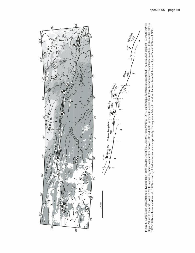
The Kunlun FaultThe Kunlun fault system is ~1600 km long and extends
between 87°E and 105°E, from the high Qiangtang platform of northern Tibet, a dry permafrost plateau over 5000 masl, down to the humid, forested and deeply incised (2000 m a.s.l. on average) mountainous rim of southern China’s Sichuan basin (Fig. 1). On a large scale, the Kunlun fault system follows the northeastern border of the highest part of the Tibetan Plateau and is composed of twelve principal, linear segments (Fig. 6) (Van der Woerd et al., 1998, 2000, 2002b). It has been one of the more historically active strike-slip faults in central Asia, and the largest earthquakes recorded in the twentieth century in northern Tibet (Gu et al., 1989) ruptured segments of these sinistral faults or nearby thrusts. In particular, three large earthquakes—January 7, 1937, April 19, 1963, and March 24, 1971—ruptured the central stretch of the Kunlun fault, with magnitudes of 7.5, 7.1, and 6.4, respectively (e.g., Cui and Yang, 1979; Gu et al., 1989; Tapponnier and Molnar, 1977). Together, the 1963 and 1937 surface breaks were reported to reach a cumulative length of ~300 km, with maximum hori-zontal displacements of 7–8 m (e.g., Li and Jia, 1981; Molnar and Lyon Caen, 1989). On November 8, 1997, the Manyi earthquake, the largest earthquake ever recorded instrumentally in northern Tibet (Ms = 7.9), ruptured one of the westernmost, N80°E-strik-ing segments of the Kunlun fault, between 86°E and 90°E (Peltzer et al., 1999), a feature previously mapped on Landsat images by Tapponnier and Molnar (1977). The rupture length was in excess of 150 km, and the maximum horizontal slip, ~7 m (Peltzer et al., 1999). Then on November 14, 2001, the M 7.8 Kokoxili earth-quake ruptured the Kusai Hu segment of the Kunlun fault over a length of ~300 km (Van der Woerd et al., 2002a).
Prior to the availability of cosmogenic dating, the average Quaternary slip rate at the Kunlun Pass was estimated to be between 10 and 20 mm/yr (Kidd and Molnar, 1988), and GPS
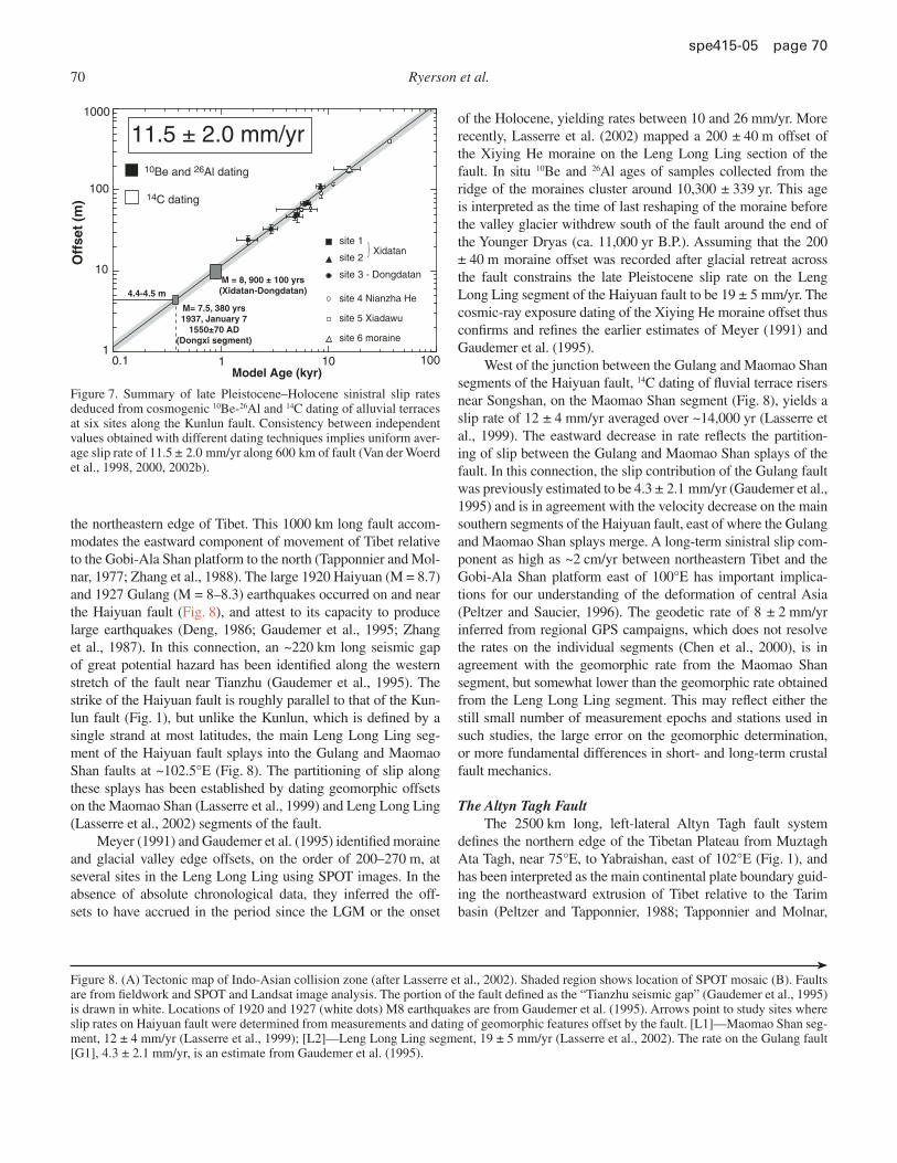
results suggested a rate as small as 6 mm/yr (Burchfi el et al., 1998) or ~8–11 mm/yr (Zhang et al., 2004). The millennial geo-morphic slip rate has been determined at 13 locations along the Xidatan-Dongdatan, Dongxi Co, and Maqen segments of the fault (Fig. 6), a stretch spanning ~600 km of the Kunlun fault system (Van der Woerd et al., 1998, 2000, 2002b). In the west, at three sites along the Xidatan-Dongdatan segment of the fault, near 94°E, terrace riser offsets ranging from 24 to 110 m, with cos-mogenic ages ranging from ca. 1800 to ca. 8200 yr B.P., yield a mean left-lateral slip rate of 11.7 ± 1.5 mm/yr. At two sites along the Dongxi-Anyemaqin segment of the fault, near 99°E, terrace riser offsets ranging from 57 to 400 m with 14C ages ranging from 5400 to 37,000 yr B.P. yield a minimum slip rate of ~10 mm/yr, comparable to that in the west. Farther east, near 100.5°E, along the Maqen segment of the fault, the 180 m offset of a lateral moraine emplaced between the Last Glacial Maximum (20 ka) and 11,100 yr B.P. yields a mean slip rate of 12.5 ± 2.5 mm/yr. The slip rate thus appears to be constant along the 600 km of the Kunlun fault studied. The average rate is 11.5 ± 2.0 mm/yr over the last 37,000 yr (Fig. 7) and is in agreement with the higher, most recent GPS estimates (Zhang et al., 2004).
A number of important conclusions can be drawn from the late Quaternary distribution of slip along the Kunlun fault sys-tem. From a methodological standpoint, the same rate is obtained using either 10Be or 26Al cosmogenic dating of quartz or radio-carbon dating of organic material. This indicates that (1) the production rates at these elevations and latitudes are reasonably accurate and (2) that the cosmogenic ages are not signifi cantly infl uenced by predepositional inheritance or erosion. At the larg-est scales, the spatial constancy of the rate is consistent with the simple geometry of the fault system, which at any longitude is characterized by a single strand. Also, unlike the Altyn Tagh fault, the Kunlun fault does not appear to have any clear-cut spa-tial relationship to high-angle shortening features—large thrusts and growing mountain ranges—that characterize the northeast-ern edge of the plateau. Hence, the potential for slip partition-ing involving other genetically related faults is minimized. The temporal constancy of the slip rate demonstrates that the Kunlun fault does not manifest any secular velocity variations for time periods greater than ~2000 yr, the age of the youngest offset mea-sured. Recently, based on three-dimensional paleoseismology at Wrightwood, California, Weldon et al. (2004) show that the slip rate on the San Andreas fault varied between 8.9 and 2.4 cm/yr over the last 2000 yr, spanning 14 seismic cycles. The timescale over which this variation is observed is essentially equivalent to that averaged by the youngest dated feature on the Kunlun fault. The similarity of the cosmogenically derived slip rate on the Kunlun fault to that derived from the essentially instantaneous geodetic results suggest that secular variations in slip rate do not persist over ~2000 yr.
The Haiyuan FaultTogether with the Altyn Tagh and Kunlun faults, the Hai-
yuan fault is one of the main left-lateral strike-slip faults defi ning
Morphochronology and the active tectonics of Tibet 69
spe 415-05 page 69
7.5
1937
.1.7
8701
07
7103
24
6.4
7.1
6304
19
8003
06
Kus
ai H
uX
idat
an D
ongd
atan
Ala
g H
uD
ongx
i Co
Maq
enM
in S
han
N10
0N
100
N90
N12
0
N11
0
N11
5
250k
m
1
23
4
5
6
86˚
86˚
88˚88
˚
90˚90
˚
92˚92
˚
94˚
94˚
96˚
96˚
98˚
98˚
100˚
100˚
102˚
102˚
104˚
104˚
34˚
36˚
36˚
34˚
842
7.5
1937
.010
7
1902
-193
1573
13811
25
1879
-47
7309
08
7308
16
7307
14
7307
14
6610
14
7505
05
6304
1971
0324
6403
16
7208
30
7208
30
7308
11
8102
09
8504
21
8505
2094
1228
8003
06
8905
13
8311
05
8811
2588
1105
9212
2281
0609
8608
20
8007
1277
0119
8508
11
9409
23
9507
0990
0426
9010
20
9507
21
8701
07
9711
08
7.9
KU
NL
UN
S
HA
N
Jin
s
ha J
ian
g
AN
YE
MA
QE
N S
HA
NH
ua
ng
He
MIN
SHAN
KO
KO
NO
R
TA
NG
UL
A
SH
AN
QA
ID
AM
45
6
12
3
Figu
re 6
. Lar
ge-s
cale
seg
men
tatio
n of
Kun
lun
faul
t (af
ter V
an d
er W
oerd
et a
l., 2
002b
). F
rom
91°
E to
105
°E, s
ix p
rinc
ipal
seg
men
ts a
re id
entifi
ed.
The
Min
Sha
n se
gmen
t (10
3°E
to 1
05°E
) st
eps
~50
km to
the
nort
h. W
est o
f 91
°E, s
ever
al s
egm
ents
, with
str
ikes
bet
wee
n 70
° an
d 12
0°, l
inke
d w
ith n
orm
al f
aults
for
m b
road
wes
tern
hor
seta
il te
rmin
atio
n. I
nstr
umen
tal (
USG
S 19
77–1
998)
and
his
tori
cal (
Gu
et a
l., 1
989)
sei
smic
ity, fi
lled
and
ope
n ci
rcle
s, r
espe
ctiv
ely,
for
mag
nitu
de M
s >
4. F
ocal
mec
hani
sms
from
Mol
nar
and
Lyon
-Cae
n (1
989)
and
USG
S.
70 Ryerson et al.
spe 415-05 page 70
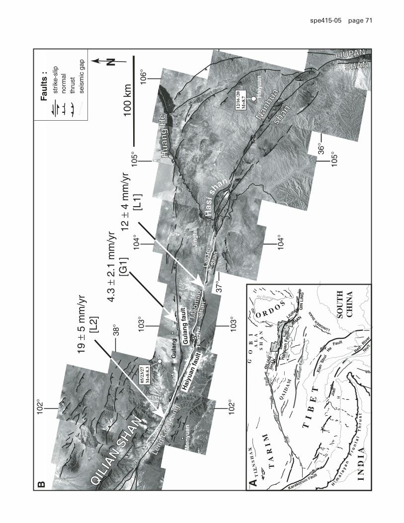
the northeastern edge of Tibet. This 1000 km long fault accom-modates the eastward component of movement of Tibet relative to the Gobi-Ala Shan platform to the north (Tapponnier and Mol-nar, 1977; Zhang et al., 1988). The large 1920 Haiyuan (M = 8.7) and 1927 Gulang (M = 8–8.3) earthquakes occurred on and near the Haiyuan fault (Fig. 8), and attest to its capacity to produce large earthquakes (Deng, 1986; Gaudemer et al., 1995; Zhang et al., 1987). In this connection, an ~220 km long seismic gap of great potential hazard has been identifi ed along the western stretch of the fault near Tianzhu (Gaudemer et al., 1995). The strike of the Haiyuan fault is roughly parallel to that of the Kun-lun fault (Fig. 1), but unlike the Kunlun, which is defi ned by a single strand at most latitudes, the main Leng Long Ling seg-ment of the Haiyuan fault splays into the Gulang and Maomao Shan faults at ~102.5°E (Fig. 8). The partitioning of slip along these splays has been established by dating geomorphic offsets on the Maomao Shan (Lasserre et al., 1999) and Leng Long Ling (Lasserre et al., 2002) segments of the fault.
Meyer (1991) and Gaudemer et al. (1995) identifi ed moraine and glacial valley edge offsets, on the order of 200–270 m, at several sites in the Leng Long Ling using SPOT images. In the absence of absolute chronological data, they inferred the off-sets to have accrued in the period since the LGM or the onset
of the Holocene, yielding rates between 10 and 26 mm/yr. More recently, Lasserre et al. (2002) mapped a 200 ± 40 m offset of the Xiying He moraine on the Leng Long Ling section of the fault. In situ 10Be and 26Al ages of samples collected from the ridge of the moraines cluster around 10,300 ± 339 yr. This age is interpreted as the time of last reshaping of the moraine before the valley glacier withdrew south of the fault around the end of the Younger Dryas (ca. 11,000 yr B.P.). Assuming that the 200 ± 40 m moraine offset was recorded after glacial retreat across the fault constrains the late Pleistocene slip rate on the Leng Long Ling segment of the Haiyuan fault to be 19 ± 5 mm/yr. The cosmic-ray exposure dating of the Xiying He moraine offset thus confi rms and refi nes the earlier estimates of Meyer (1991) and Gaudemer et al. (1995).
West of the junction between the Gulang and Maomao Shan segments of the Haiyuan fault, 14C dating of fl uvial terrace risers near Songshan, on the Maomao Shan segment (Fig. 8), yields a slip rate of 12 ± 4 mm/yr averaged over ~14,000 yr (Lasserre et al., 1999). The eastward decrease in rate refl ects the partition-ing of slip between the Gulang and Maomao Shan splays of the fault. In this connection, the slip contribution of the Gulang fault was previously estimated to be 4.3 ± 2.1 mm/yr (Gaudemer et al., 1995) and is in agreement with the velocity decrease on the main southern segments of the Haiyuan fault, east of where the Gulang and Maomao Shan splays merge. A long-term sinistral slip com-ponent as high as ~2 cm/yr between northeastern Tibet and the Gobi-Ala Shan platform east of 100°E has important implica-tions for our understanding of the deformation of central Asia (Peltzer and Saucier, 1996). The geodetic rate of 8 ± 2 mm/yr inferred from regional GPS campaigns, which does not resolve the rates on the individual segments (Chen et al., 2000), is in agreement with the geomorphic rate from the Maomao Shan segment, but somewhat lower than the geomorphic rate obtained from the Leng Long Ling segment. This may refl ect either the still small number of measurement epochs and stations used in such studies, the large error on the geomorphic determination, or more fundamental differences in short- and long-term crustal fault mechanics.
The Altyn Tagh FaultThe 2500 km long, left-lateral Altyn Tagh fault system
defi nes the northern edge of the Tibetan Plateau from Muztagh Ata Tagh, near 75°E, to Yabraishan, east of 102°E (Fig. 1), and has been interpreted as the main continental plate boundary guid-ing the northeastward extrusion of Tibet relative to the Tarim basin (Peltzer and Tapponnier, 1988; Tapponnier and Molnar,
0.1 1 10 1001
10
100
1000
Model Age (kyr)
Off
set
(m)
site 1
site 2
site 3 - Dongdatan
site 6 moraine
site 5 Xiadawu
site 4 Nianzha He
Xidatan}
11.5 ± 2.0 mm/yr
14C dating
10Be and 26Al dating
4.4-4.5 m
M = 8, 900 ± 100 yrs(Xidatan-Dongdatan)
M= 7.5, 380 yrs1937, January 7
1550±70 AD(Dongxi segment)
Figure 7. Summary of late Pleistocene–Holocene sinistral slip rates deduced from cosmogenic 10Be-26Al and 14C dating of alluvial terraces at six sites along the Kunlun fault. Consistency between independent values obtained with different dating techniques implies uniform aver-age slip rate of 11.5 ± 2.0 mm/yr along 600 km of fault (Van der Woerd et al., 1998, 2000, 2002b).
Figure 8. (A) Tectonic map of Indo-Asian collision zone (after Lasserre et al., 2002). Shaded region shows location of SPOT mosaic (B). Faults are from fi eldwork and SPOT and Landsat image analysis. The portion of the fault defi ned as the “Tianzhu seismic gap” (Gaudemer et al., 1995) is drawn in white. Locations of 1920 and 1927 (white dots) M8 earthquakes are from Gaudemer et al. (1995). Arrows point to study sites where slip rates on Haiyuan fault were determined from measurements and dating of geomorphic features offset by the fault. [L1]—Maomao Shan seg-ment, 12 ± 4 mm/yr (Lasserre et al., 1999); [L2]—Leng Long Ling segment, 19 ± 5 mm/yr (Lasserre et al., 2002). The rate on the Gulang fault [G1], 4.3 ± 2.1 mm/yr, is an estimate from Gaudemer et al. (1995).
Morphochronology and the active tectonics of Tibet 71
spe 415-05 page 71
Hu
ang
He
Hu
ang
He
Men
yuan
Jin
gta
i
Hai
yuan
Tia
nzh
u
Gu
lan
g
N
QIL
IAN
SHAN
QIL
IAN
SHAN
LIUPANLIUPAN
Nan
hua
Nan
hua
shan
shan
Fau
lts
:st
rike-
slip
norm
alth
rust
100
km
SHANSHAN
Mao
mao
Mao
mao
shan
shan
Leng
Lon
g Li
ng
Leng
Lon
g Li
ngH
aiyu
an fa
ult
Gu
lan
g f
ault
Has
i shan
seis
mic
gap
Lao
Hu
L
ao H
u
Sh
anS
han
19 ±
5 m
m/y
r[L
2]
4.3
± 2.
1 m
m/y
r[G
1]12
± 4
mm
/yr
[L1]
Alty
n
T
agh
F
ault
QIN
LIN
G
QA
IDA
M
LUNGMEN SH
AN
TI
EN
SH
AN
TA
RI
M
O R D OS
GO
BI
AL
AS
HA
N
Jial
i
He
Fault
QIL
IAN
SH
AN
Xia
n
Red
Riv
er
Hi m
al a
ya
n
F
r on
t al
T
hr
us
t
Karakorum Fault
SOU
TH
CH
INA
I N
D I
Afa
ult
LIUPAN
SHAN
Ku
nlu
n F
ault
Shui
TI
BE
T
Hai
yuan
Fau
lt
Huang He
B A
106°
38°
37°
36°
105°
105°
104°
104°
103°
103°
102°
102°
05/2
3/27
M=8
-8.3
12/1
6 /2
0M
=8.7

72 Ryerson et al.
spe 415-05 page 72
1977). Seismic tomography suggests that a deep shear zone extend beneath the fault to the base of the lithosphere (Wittlinger et al., 1998, 2004), but the magnitude of the millennial and Ceno-zoic slip rates and total offsets along the fault remain controver-sial, with estimates of the sinistral slip rate ranging from 2 mm/yr to 40 mm/yr (Bendick et al., 2000; Ge et al., 1992; Mériaux et al., 2004; Peltzer et al., 2000; Shen et al., 2001b; Wang et al., 2001; Washburn et al., 2001; Zhang et al., 2004).
A number of total-offset markers along the Altyn Tagh fault have now been defi ned and the long-term Cenozoic, geologic slip rates inferred. The majority of the pre-Tertiary piercing points are found along the central and eastern portions of the fault and yield offsets ranging from 260 to 500 km (Gehrels et al., 2003; Ritts and Biffi , 2000; Sobel et al., 2001; Yang et al., 2001; Yin et al., 2002; Yue et al., 2001). Near the western termination of the fault, Peltzer and Tapponnier (1988) noted that Paleozoic plutons in the western Kunlun have been offset by >500 km across the Altyn Tagh fault. A more recent reevaluation of this offset using addi-tional age constraints yields a similar estimate of the total offset, 475 ± 75 km (Cowgill et al., 2003). Based upon the history of sed-imentation for the southwestern Tarim basin, Qaidam basin, and Hexi corridor, Yin et al. (2002) infer that thrusting in the western Kunlun and along the Qiman Tagh and northern Qaidam thrust systems began prior to 46 Ma and ca. 49 Ma, respectively. Inter-preting these thrust systems as termination or branching faults of
the Altyn Tagh fault, they conclude that the fault must have been active since ca. 49 Ma, and that, combined with the 475 ± 75 km offset of Paleozoic plutons in the western Kunlun, the long-term slip rate is ~9 mm/yr. However, the temporal constraints must be viewed as somewhat controversial, as the proposed initiation of slip on the Altyn Tagh fault would predate that initiation of slip on the Red River shear zone, ca. 36 Ma (Gilley et al., 2003), and slip on the Gangdese thrust system, ca. 27 Ma (Yin et al., 1994). Both features lie signifi cantly closer to the Indo-Asian boundary, and the proposed chronology would imply an “out-of-sequence” onset of continental deformation. In this connection others, e.g., Yue et al. (2001), have proposed an Oligo-Miocene initiation of slip on the Altyn Tagh fault. As such, the 9 mm/yr slip rate is best considered as a lower bound on the integrated Cenozoic slip rate. Similarly, Yue et al. (2001) have reconstructed the offsets for the Xorkol basin (91°–92°E), north of the Altyn Tagh fault, and its inferred Oligocene and post–Early Miocene source regions to the south, obtaining offsets of ~380 km and 300 km, respectively, yielding a long-term slip rate of 12–16 mm/yr. The Qilian Shan lies at the eastern termination of the Altyn Tagh fault, a region of active shortening. Any post-Miocene shortening would result in an underestimate of the observed offset, and this observation may also constitute a lower bound.
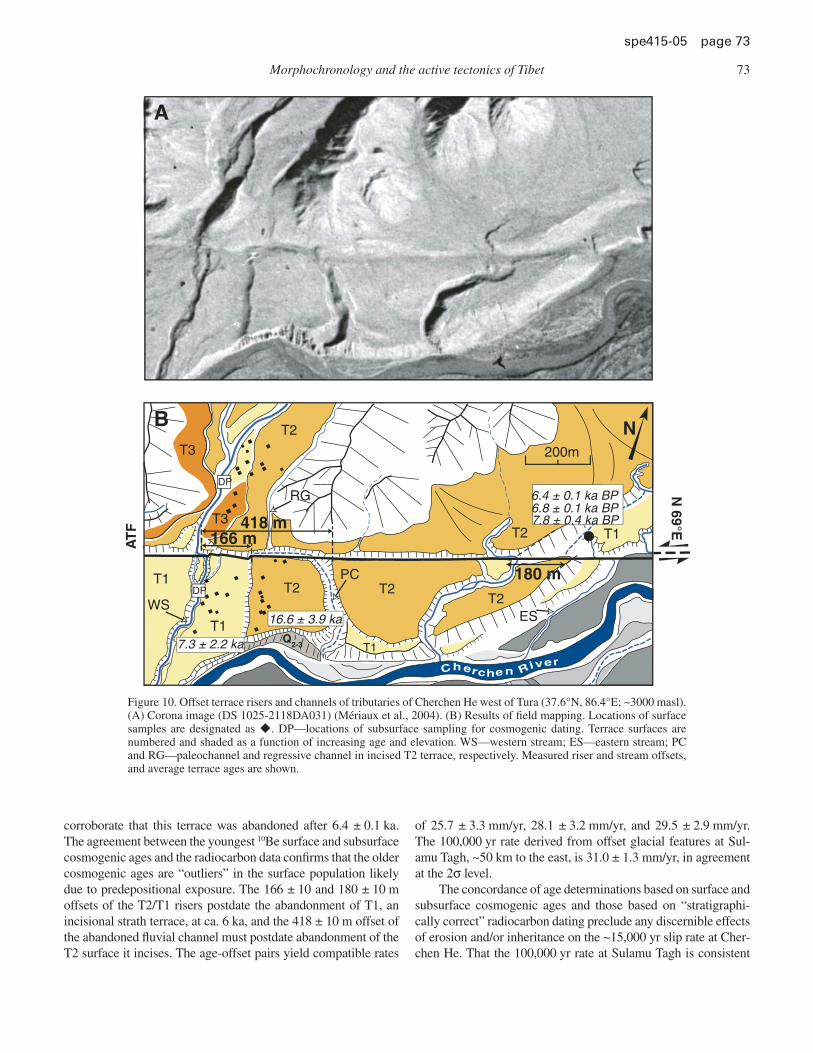
Mériaux et al. (2004) have determined the ages of fl uvial and glacial geomorphic markers left-laterally displaced along the central segment of the Altyn Tagh fault using radiocarbon and 10Be-26Al cosmic-ray exposure dating (Fig. 1). Two sites near Tura (~37.6°N, 86.6°E) were investigated: Cherchen He and Sulamu Tagh. Here, the Altyn Tagh fault is characterized by a single strand, and geomorphic slip-rate determinations, therefore, capture the full rate on the fault. The sites are geomorphologi-cally distinct, with Cherchen He dominated by fl uvial processes recording offsets between 166 and 420 m, and Sulamu Tagh by glacial action with offsets between 470 and 3660 m. Nine offsets with ages between 6 and 113 ka yield a constant average slip rate of 26.9 ± 6.9 mm/yr (Fig. 9), well in excess of the Cenozoic and geodetic slip-rate estimates (Bendick et al., 2000; Wallace et al., 2004). The lack of secular variation of the rate is consistent with and extends the results obtained on the Kunlun fault (Van der Woerd et al., 1998, 2000, 2002b).
With respect to the use and consistency of cosmogenic dat-ing as applied to active tectonics, the Cherchen He site is of par-ticular interest. At the Cherchen River site west of Tura, the Altyn Tagh fault cuts fl uvial terraces, offsetting their risers (T2/T1) and an abandoned channel (“PC” in Fig. 10). The timing of terrace abandonment was determined by 10Be and 26Al cosmic-ray sur-face exposure dating of quartz cobbles from the surfaces of T1 and T2 and subsurface samples from T1. The average ages from cosmogenic dating of surface samples are 14.2 ± 1.3 ka for T2 and 6.5 ± 0.7 ka for T1 (Fig. 11). The youngest depth-corrected ages for subsurface samples in the T1 depth profi le yield a maxi-mum age for the T1 surface (younger than 6 ka), in good agree-ment with the youngest surface ages. The radiocarbon ages of three charcoal samples found in T1 on the east side of the site
26.9
± 6
.9 m
m/y
r
CP
EC
M1
VW
S1, S2, PC
T2/T1
0 20 40 60 80 100 120 1400
500
1000
1500
2000
2500
3000
3500
4000
Model Age (ka)
Off
set
(m)
Sulamu Tagh site
Cherchen he site
Figure 9. Slip-rate summary on the central Altyn Tagh fault during the last glacial cycle (Mériaux et al., 2004). Open symbols are the pre-ferred slip-rate estimates yielding a bracket of 25–35 mm/yr; the lower bound is largely controlled by the Cherchen He data. The linear regres-sion of the nine data points that determine the upper slip-rate estimates yields a rate of 26.9 ± 6.9 mm/yr.
Morphochronology and the active tectonics of Tibet 73
spe 415-05 page 73
corroborate that this terrace was abandoned after 6.4 ± 0.1 ka. The agreement between the youngest 10Be surface and subsurface cosmogenic ages and the radiocarbon data confi rms that the older cosmogenic ages are “outliers” in the surface population likely due to predepositional exposure. The 166 ± 10 and 180 ± 10 m offsets of the T2/T1 risers postdate the abandonment of T1, an incisional strath terrace, at ca. 6 ka, and the 418 ± 10 m offset of the abandoned fl uvial channel must postdate abandonment of the T2 surface it incises. The age-offset pairs yield compatible rates
of 25.7 ± 3.3 mm/yr, 28.1 ± 3.2 mm/yr, and 29.5 ± 2.9 mm/yr. The 100,000 yr rate derived from offset glacial features at Sul-amu Tagh, ~50 km to the east, is 31.0 ± 1.3 mm/yr, in agreement at the 2σ level.
The concordance of age determinations based on surface and subsurface cosmogenic ages and those based on “stratigraphi-cally correct” radiocarbon dating preclude any discernible effects of erosion and/or inheritance on the ~15,000 yr slip rate at Cher-chen He. That the 100,000 yr rate at Sulamu Tagh is consistent
200m
166 m418 m
180 mT2
T1
T2 T1
T1
T1T2
T2
T2T3
AT
FN
69°E
N
ESWS
PC
RG
Cherchen River
T3
Q2-3
A
B
7.3 ± 2.2 ka
16.6 ± 3.9 ka
6.8 ± 0.1 ka BP6.4 ± 0.1 ka BP
7.8 ± 0.4 ka BP
DP
DP
Figure 10. Offset terrace risers and channels of tributaries of Cherchen He west of Tura (37.6°N, 86.4°E; ~3000 masl). (A) Corona image (DS 1025-2118DA031) (Mériaux et al., 2004). (B) Results of fi eld mapping. Locations of surface samples are designated as u. DP—locations of subsurface sampling for cosmogenic dating. Terrace surfaces are numbered and shaded as a function of increasing age and elevation. WS—western stream; ES—eastern stream; PC and RG—paleochannel and regressive channel in incised T2 terrace, respectively. Measured riser and stream offsets, and average terrace ages are shown.
74 Ryerson et al.
spe 415-05 page 74
with the rate at Cherchen He suggests that the longer-term mea-surement is similarly unaffected by erosion and/or inheritance. This issue will be discussed further below.
The eastern stretch (from 90°E to 97°E) of the Altyn Tagh fault strikes N70°E overall but has a complex geometry (Fig. 12) that has been described in detail (Mériaux et al., 2005). Between the western edge of the Qaidam basin and the Qilian range, the fault system comprises three principal parallel strands (Ge et al., 1992; Meyer et al., 1998; Peltzer et al., 1989; Van der Woerd et al., 2001). The southern strand or South Altyn Tagh fault follows the Qaidam side of the Altyn push-up, and then veers southeast-ward into the Tanghenan Shan. The northern strand follows the edge of the Tarim block from the Altyn to the Qilian Shan thrust fronts. East of the Qilian Shan front, the northern strand (North Altyn Tagh fault) continues with a N96°E strike north of the Hexi corridor. Finally, the central strand or Yema fault jogs southward from the North Altyn Tagh fault between Aksay and Subei and continues northeastward to the Taxue Shan thrust front.
The multiple strands and spatially related thrust faults that characterize the eastern Altyn Tagh fault provide mechanisms for transfer of slip from the main segment of the fault, and eastward-decreasing geomorphic slip rates do appear to confi rm this effect. Millennial slip rates have been determined for the Altyn Tagh fault at three sites near Aksay (~94°E) along the piedmont of the Dangjin Shankou range in northeastern Tibet through a combina-tion of offset measurements of fl uvial channels and terrace risers
0
5
10
15
20
25
30
35
40
7.3 ± 2.2 Ka(MSWD = 21.4)
14C = 6.4 KaSubsurface
10Be = 6 Ka
16.6 ± 3.9 Ka(MSWD = 11.5)
Mod
el A
ge (
ka)
T1 T2
Figure 11. 10Be exposure model age determinations at Cherchen He (Mériaux et al., 2004). The average values are simple unweighted means with errors equal to one standard deviation for surface samples. The 1σ brackets on the average ages are shown as the shaded regions on the fi gure. 10Be ages of samples included in the average are shown as open symbols; fi lled symbols are for ages that were considered as outliers. Surface samples are shown as open and fi lled circles, and depth-corrected ages of subsurface samples are shown as open and fi lled squares. Radiocarbon ages are shown as open triangles. Surface samples yield an average age of 7.3 ± 2.2 ka for T1 and an average of 16.6 ± 3.9 ka for T2. Sample TU3-71, 71.8 ± 4.6 ka, has not been plot-ted in order to improve the resolution in the age range of interest.
Tarim
GO
BI
Ala
Sha
n
Qai
dam
Tang
He
Nan Shan
Dax
ue S
han
Qili
an S
han
Alt
un
Sh
an
Mah
an s
han
Tash
i sh
an
Sa
n w
ei
sha
n
Alty
n p
ush
up
Du
nh
ua
ng
Su
be
i
Aks
ay
An
na
nb
a
Altu
n pa
ss
La
pe
i Q
ua
n
Ch
an
g m
a
Yu
me
n
Sh
iba
och
en
g
Xo
rko
l
Le
ng
hu
Yem
a f
au
lt
Pin
gdin
g s
ha
n
Xo
rko
l-L
ap
ei
Qu
an
-Se
g.
An
na
nb
a S
eg
.A
ks
ay S
eg
.Ta
sh
i s
eg
.S
ule
He
Se
g.
Alt
un
Seg
.
Da
ng
jin
Sh
an
kou
Se
g.
~2
00
km
~6
0 k
m
~7
0 k
m~
95
km
~1
00
km
~9
0 k
m
~1
00
km
A.
Jc
t.S
u.
Jc
t.Y
.J
ct.
Sh
.J
ct.
91°
90°
92°
93°
94°
95°
96°
97°
91°
92°
93°
94°
95°
96°
97°
98°
40°
38°39
°
HI M
AL
AY
AS
MF
T
TIB
ET
90˚
30˚
80˚
100˚
40˚
ATF
A
BFigu
re 1
2. A
ksay
seg
men
tatio
n m
ap. T
ecto
nic
map
of
nort
hern
Tib
et. (
A)
Tect
onic
map
of
Tib
et. T
he s
hade
d re
gion
giv
es t
he l
o-ca
tion
of t
he A
ksay
reg
ion
of t
he A
ltyn
Tagh
Fau
lt (A
TF)
; M
FT i
s th
e M
ain
Fron
tal T
hrus
t. (B
) Se
gmen
tatio
n an
d m
ain
segm
ent
junc
tions
of
the
Alty
n Ta
gh F
ault
betw
een
the
Ping
ding
Sha
n an
d th
e Q
ilian
Sha
n (a
fter
Mér
iaux
et
al.,
2005
). A
. Jct
—A
nnan
ba
Junc
tion;
Su.
Jct
.—Su
bei J
unct
ion;
Sh.
Jct
.—Sh
ibao
chen
g Ju
nctio
n; Y
. Jct
.—Y
umen
Jun
ctio
n.
Morphochronology and the active tectonics of Tibet 75
spe 415-05 page 75
coupled with radiocarbon and 10Be and 26Al surface exposure dat-ing (Mériaux et al., 2005). Cumulative offsets range from 20 m to 260 m and fall in distinct groups, indicative of climatically mod-ulated regional landscape formation, and at least nine different surfaces have been defi ned based upon morphology, elevation, and dating. The abandonment ages of several of these surfaces are constrained by radiocarbon dating of subsurface charcoals. The majority of the samples are younger than ca. 14 ka, postdat-ing the LGM. The end of the Early Holocene Optimum marks the boundary between the ages of the two main terrace levels at 5–6 ka. The radiocarbon ages typically coincide with the youngest cosmogenic ages for a particular surface. Surface exposure ages older than the radiocarbon dates are taken to represent diachron-ous terrace emplacement with a fi nite time interval between the onset of emplacement and abandonment. Explicit in this assump-tion is the possibility that some fraction of the offset of a terrace riser could have accumulated prior to abandonment of the under-lying terrace. Slip rates are obtained by matching the riser offsets with both (1) the abandonment/emplacement ages of the terrace underlying the riser and (2) the abandonment ages of the terrace levels above (the “strath abandonment” and “strath emplace-ment” models described earlier), and provide bounding estimates on the slip rate (Fig. 13). Rates derived from channel offsets are determined using the age of the surface incised by the channel. Overall, slip-rate estimates using the abandonment age of the overlying level for fi ll terraces or channels and the emplacement of the underlying level for strath terraces give consistent results, with 32 determinations yielding an average Holocene rate of 17.8 ± 3.6 mm/yr (Fig. 13). As the Altyn Tagh fault is divided into a northern and southern branch at this longitude, the rate of the northern Altyn Tagh fault should thus be considered a minimum for the overall Altyn Tagh fault system. The Altyn Tagh fault slip rate at Aksay is 9 mm/yr less than the geomorphic rate obtained near Tura at ~87°E (26.9 ± 6.9 mm/yr), in keeping with the infer-ence of an eastward-decreasing rate on the fault, due to increased thrusting to the south.
Regardless of any spatial variability in slip rate along the Altyn Tagh fault, the difference in millennial and geodetic slip rates is diffi cult to reconcile. For instance, GPS surveys across the central portion of the fault (~90°E) conducted in 1994, 1998, and 2002 yield a rate of 9 ± 4 mm/yr (Bendick et al., 2000; Wallace et al., 2004). Similarly, InSAR observation of the western Karakax Valley segment of the fault (82°E; Fig. 1) yields a slip rate of 5 ± 5 mm/yr (Wright et al., 2004). Both geodetic rates are substantially smaller than the millennial esti-mates. Wallace et al. (2004) conclude that the disparity is due to “systematic error that biases” geologic slip velocities to higher values. Given the agreement between radiocarbon, surface, and subsurface cosmogenic dating, it is not clear what these “ines-capable” biases might be. Instead, we emphasize that the slip rates on the San Andreas fault at Wrightwood have varied by a factor of ~3.5 within the past 2000 yr (Weldon et al., 2004). Secular variations of this magnitude would reconcile millennial and geodetic rates on the Altyn Tagh fault, but the true nature
and existence of this disparity must be confi rmed by further millennial and decadal rate determinations.
The Karakorum FaultThe Karakorum fault is the main Quaternary right-lateral
fault north of the Himalayas and trends roughly parallel to the western Himalayan range, extending from at least Mount Kailas to the Pamir, a length of >1200 km (Fig. 1). As the Altyn Tagh fault defi nes the northern edge of the Tibetan Plateau, the Karako-rum fault defi nes at least the western portion of its southern bor-der, and its slip rate has similar implications for the rheological character of the continental lithosphere and is a subject of active debate. Attempts to determine the rate over timescales ranging from the Oligo-Miocene to the Quaternary have produced dispa-rate values ranging from 1 to 30 mm/yr (Banerjee and Burgmann, 2002; Brown et al., 2002a; Chevalier et al., 2005a; Lacassin et al., 2004; Liu, 1993; Murphy et al., 2002; Phillips et al., 2004; Wang et al., 2001; Wright et al., 2004).
Unlike the Altyn Tagh fault, the disparity in rate estimates on the Karakorum fault is not strictly a function of observational technique, however, and helps to point out an important distinction between estimates derived from geodesy and morphochronology. The InSAR observations of Wright et al. (2004) provide the most recent geodetic slip-rate estimate for the Karakorum fault. Using observations taken between 1992 and 1999, they obtain a rate of 1 ± 3 mm/yr. Based on cosmogenic dating, the geomorphic rate
0 5 10 15 20
50
100
150
200
250
300
350
400 Strath EmplacementFill Abandon
Model Ages (ka)O
ffse
t (m
)
17.8
± 3.6
mm
/yr
21.4
mm
/yr
14.2 mm/yr
Figure 13. Aksay offset versus model age. Slip rate estimates are de-rived from using the age of the overlying surface for fi ll terraces and channels and the emplacement age of the underlying surface for strath terraces, yielding an average Holocene rate of 17.8 ± 3.6 mm/yr (after Mériaux et al., 2005).
76 Ryerson et al.
spe 415-05 page 76
determined on a single strand of the Karakorum fault north of Bangong Lake is 4 ± 1 mm/yr (Brown et al., 2002a), in apparent agreement with the geodetic results. However, this geomorphic rate must be considered a minimum value as it only samples the northern of the two strands of the fault at this longitude, ~78°E (Fig. 1). While geodetic methods sample far-fi eld deformation, capturing all of the motion distributed among the various strands of a fault system, the geomorphic rates are only representative of the motion on the strand on which the offset is observed. Motion accommodated on other strands within the system must be mea-sured independently. A similar debate concerns the integrated Oligo-Miocene slip rate on the Karakorum fault. Phillips et al. (2004) estimate a total offset of 40–150 km to have accumulated on the fault west of Mount Kailas during the last ~15 m.y., yield-ing an integrated rate of 2–10 mm/yr. Lacassin et al. (2004) esti-mate a larger cumulative offset (~250 km) and earlier initiation of motion on this section of the fault (ca. 23 Ma), yielding a rate at the upper end of that proposed by Phillips et al. (2004). More importantly, Lacassin et al. (2004) propose that dextral slip along the Indus-Tsangpo suture east of Mount Kailas may have accom-modated a similar cumulative offset, doubling the total offset and associated slip rate. Hence, the existing investigations of both the geologic and active slip rates on the Karakorum fault highlight the need for regional mapping of both active and geologic faults prior to smaller-scale analysis and sampling and that, other fac-tors aside, the rates on a single strand of a complex fault system are necessarily minimum values.
Chevalier et al. (2005a) determined a millennial slip rate on one branch of the Karakorum fault at the Manikala glacial valley terminus, west of the Gar basin (32°2.529′N, 80°1.212′E; Fig. 14) using 10Be surface exposure dating of dextrally offset moraines. The Manikala moraine complex lies at the base of the faulted Ayilari range front, which bounds the west side of the Gar Valley, a large pull-apart basin fl oored by marshland that hides other strands of the Karakorum fault system (Armijo et al., 1989) (Fig. 1). The dated moraines lie northeast of the U-shaped Manikala Valley, a glacial trough deeply entrenched into the range’s igneous basement (Fig. 14). Within the till complex, two main groups of moraines are recognized (Fig. 14). All were emplaced by the Manikala Daer Glacier, whose terminus is today ~7 km upstream from the active fault trace. The morphology of the moraines indicates that they were formed during major advances of the glacier, and later aban-doned when the glacier retreated upstream.
The relative ages of the moraine groups can be qualitatively assessed from their surface characteristics (Fig. 15). The M1 sur-face is rough and composed of chaotically distributed, imbricate blocks (as large as 3 m) surrounded by coarse debris. The smoother surface of M2 appears older with blocks (tens of centimeters to a meter) protruding above a mantle of smaller debris (Fig. 15). The morainic ridges thus appear to become younger from east to west, consistent with right-lateral motion on the fault.
The M2 moraine complex is divided into eastern and west-ern sections (M2E and M2W, respectively) by a deep, beheaded, fl at-fl oored, valley (labeled “PV” in Fig. 14) that is fl anked by
well-defi ned, lateral moraines. The crest of the lateral moraine east of PV is well preserved, and its eastern edge extends to the base of the faceted range front. There is no catchment on the mountain slope facing this valley, indicating that PV must correspond to a former channel of the Manikala Daer Glacier (Fig. 14). The youngest moraine group (M1 in Fig. 14) is the only one present on both sides of the Manikala outwash valley, displaying well-preserved terminal lobes and sharply defi ned ridge crests. The lateral limits of glacial incision in the basement upstream from the fault reach the base of the triangular facets on either side of the Manikala Valley. Once restored using satellite images, the M1 and M2E offsets are 220 ± 10 m and 1520 ± 50 m, respectively.
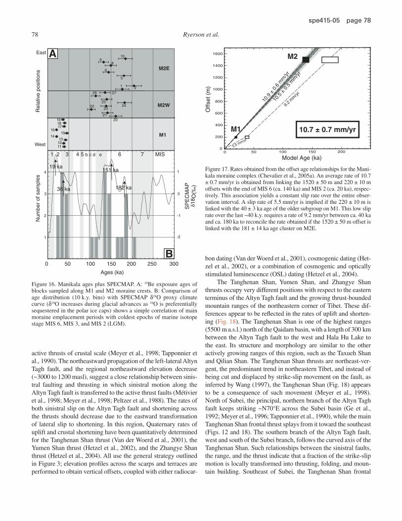
The peaks in the overall M1-M2 age distribution correspond to the coldest periods as derived from proxy paleotemperature records (e.g., SPECMAP δ18O curve; Imbrie et al., 1984; ca. 19, 36, 151, and 182 ka) (Fig. 16), and hence, to maximal glacial advance. In particular, the younger M2 samples, 140 ± 5.5 ka, correspond roughly to the glacial maximum at the end of MIS 6 (150–140 ka), the older M1 subgroup, 40 ± 3 ka, to the cold period at the end of MIS 3 (ca. 40 ka), and the youngest M1 samples, 21 ± 1.0 ka, to the LGM (19 ka). The oldest 10Be ages on M2E suggest that it was emplaced during the major glacial advance at the beginning of MIS 6, while the youngest ages on M2E are consistent with abandonment at ca. 140 ka at the begin-ning of the Eemian interglacial (Fig. 16). The bulk of the ages on the younger moraine, M1, are consistent with emplacement at ca. 40 ka. However, the younger ages on this surface suggest that it was not abandoned until the onset of post-LGM warming after ca. 20 ka.
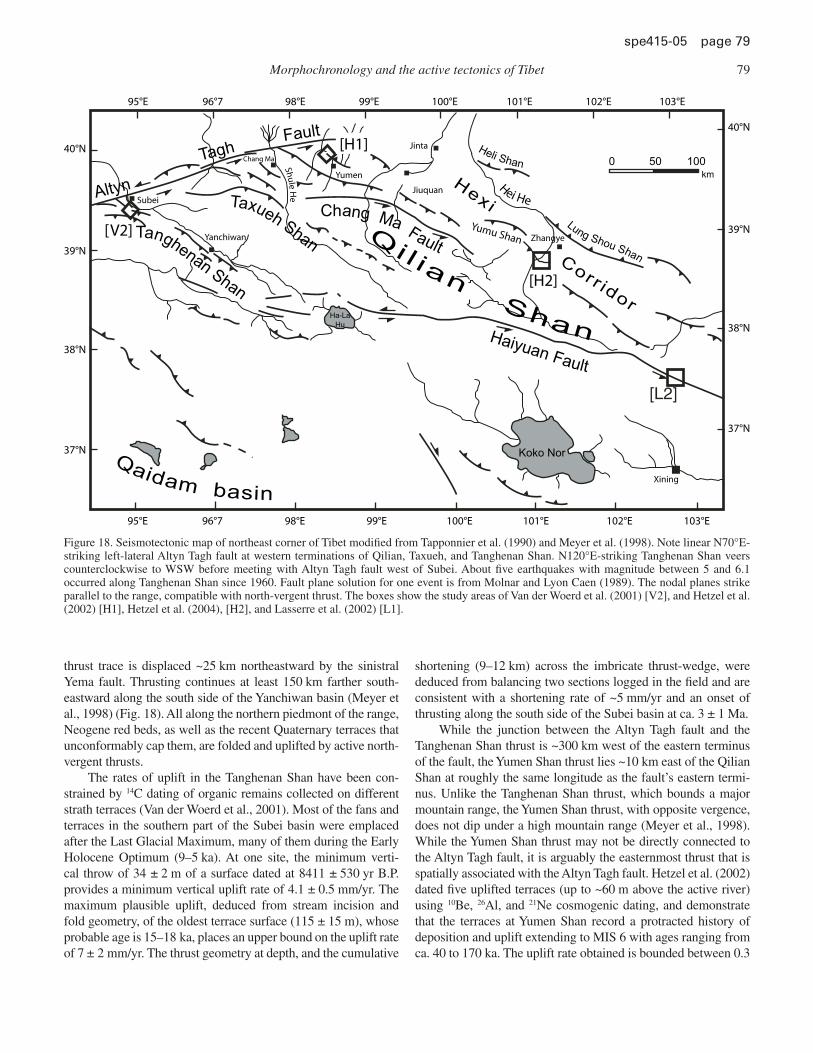
Matching the 1520 ± 50 m offset of the M2E lateral moraine with the sample ages that approximate the end of the MIS 6 gla-cial maximum (140 ± 5.5 ka) yields an average slip rate of 10.9 ± 0.6 mm/yr (Fig. 17). Likewise, matching the 220 ± 10 m offset of M1 with the age of the M1 LGM samples (21 ± 1.0 ka) yields a rate of 10.5 ± 0.5 mm/yr, corresponding to a constant right-lat-eral slip rate of 10.7 ± 0.7 mm/yr on this segment of the Karako-rum fault for the last 140,000 yr, a rate at least ten times greater than that obtained by InSAR (Wright et al., 2004). The total rate of displacement between southwestern Tibet and the western Himalayas is greater because the normal component of throw on the main fault must be taken into account, along with slip accom-modated on other active fault strands within and on the opposite side of the Gar pull-apart basin. The disagreement between the various geomorphic and geodetic slip-rate observations on the Karakorum fault is a subject of continuing debate (cf. Brown et al., 2005; Chevalier et al., 2005b) and is unlikely to be resolved without continuing investigations in these remote areas.
Geomorphic Rates of Thrusting and Crustal Shortening
The region located northeast of the Qaidam basin, between the Altyn Tagh and Haiyuan faults (Fig. 1), is characterized by several large NW-SE-trending ranges (Tapponnier and Molnar, 1977) that have been interpreted to grow as ramp anticlines on
Morphochronology and the active tectonics of Tibet 77
spe 415-05 page 77
BA
N N
100 m100 m
M1 M2
A
C D
B
Figure 14. (A) IKONOS satellite image of abandoned Manikala Glacier moraines offset by Karakorum fault. Present-day Manikala Glacier outwash (lower right corner of image) is frozen and appears white in image. (B) Map of offset moraines (orange—M2; yellow—M1) and sample locations (circles with numbers). Note abandoned glacial channel (PV—paleovalley of Manikala Glacier) east of the Manikala outwash. Mo-raines M1 and M2E are offset ~220 and 1520 m, respectively.
Figure 15. Manikala surface IKO-NOS images of lateral moraine crests M1 (A) and M2 (B) show-ing different surface morphol-ogy correlated with different age. Large blocks (dark) are visible on both moraines. C: Field photo-graph of the M1 surface. Large block in the center of the image is ~2 m across. D: Field photograph of the M2 surface (from Cheva-lier et al., 2005a).
78 Ryerson et al.
spe 415-05 page 78
active thrusts of crustal scale (Meyer et al., 1998; Tapponnier et al., 1990). The northeastward propagation of the left-lateral Altyn Tagh fault, and the regional northeastward elevation decrease (~3000 to 1200 masl), suggest a close relationship between sinis-tral faulting and thrusting in which sinistral motion along the Altyn Tagh fault is transferred to the active thrust faults (Métivier et al., 1998; Meyer et al., 1998; Peltzer et al., 1988). The rates of both sinistral slip on the Altyn Tagh fault and shortening across the thrusts should decrease due to the eastward transformation of lateral slip to shortening. In this region, Quaternary rates of uplift and crustal shortening have been quantitatively determined for the Tanghenan Shan thrust (Van der Woerd et al., 2001), the Yumen Shan thrust (Hetzel et al., 2002), and the Zhangye Shan thrust (Hetzel et al., 2004). All use the general strategy outlined in Figure 3; elevation profi les across the scarps and terraces are performed to obtain vertical offsets, coupled with either radiocar-
bon dating (Van der Woerd et al., 2001), cosmogenic dating (Het-zel et al., 2002), or a combination of cosmogenic and optically stimulated luminescence (OSL) dating (Hetzel et al., 2004).
The Tanghenan Shan, Yumen Shan, and Zhangye Shan thrusts occupy very different positions with respect to the eastern terminus of the Altyn Tagh fault and the growing thrust-bounded mountain ranges of the northeastern corner of Tibet. These dif-ferences appear to be refl ected in the rates of uplift and shorten-ing (Fig. 18). The Tanghenan Shan is one of the highest ranges (5500 m a.s.l.) north of the Qaidam basin, with a length of 300 km between the Altyn Tagh fault to the west and Hala Hu Lake to the east. Its structure and morphology are similar to the other actively growing ranges of this region, such as the Taxueh Shan and Qilian Shan. The Tanghenan Shan thrusts are northeast-ver-gent, the predominant trend in northeastern Tibet, and instead of being cut and displaced by strike-slip movement on the fault, as inferred by Wang (1997), the Tanghenan Shan (Fig. 18) appears to be a consequence of such movement (Meyer et al., 1998). North of Subei, the principal, northern branch of the Altyn Tagh fault keeps striking ~N70°E across the Subei basin (Ge et al., 1992; Meyer et al., 1996; Tapponnier et al., 1990), while the main Tanghenan Shan frontal thrust splays from it toward the southeast (Figs. 12 and 18). The southern branch of the Altyn Tagh fault, west and south of the Subei branch, follows the curved axis of the Tanghenan Shan. Such relationships between the sinistral faults, the range, and the thrust indicate that a fraction of the strike-slip motion is locally transformed into thrusting, folding, and moun-tain building. Southeast of Subei, the Tanghenan Shan frontal
Model Age (ka)
Offs
et (
m)
5.5 mm/yr
10.9
± 0
.6 m
m/y
r
10.7 ± 0.7 mm/yr
10.5
± 0
.5 m
m/yr
9.2 m
m/yr
0
200
400
600
800
1000
1200
1400
1600
0 50 100 150 200
M1
M2
Ages (ka)
0 50 100 150 200 250 300
Num
ber
of s
ampl
es
1
2
419 ka
182 ka3 0
-1
-2
1
1 2 3 4 5 b c d e 6 7 MIS
36 ka
151 ka
Rel
ativ
e po
sitio
ns
M1
M2W
M2E
δ18 O
(‰)
SP
EC
MA
P
East
West
A
B
191817
1615
1413
1112
2021
2223
2425
26 27
1 2
5
6
10
89
Figure 16. Manikala ages plus SPECMAP. A: 10Be exposure ages of blocks sampled along M1 and M2 moraine crests. B: Comparison of age distribution (10 k.y. bins) with SPECMAP δ18O proxy climate curve (δ18O increases during glacial advances as 16O is preferentially sequestered in the polar ice caps) shows a simple correlation of main moraine emplacement periods with coldest epochs of marine isotope stage MIS 6, MIS 3, and MIS 2 (LGM).
Figure 17. Rates obtained from the offset age relationships for the Mani-kala moraine complex (Chevalier et al., 2005a). An average rate of 10.7 ± 0.7 mm/yr is obtained from linking the 1520 ± 50 m and 220 ± 10 m offsets with the end of MIS 6 (ca. 140 ka) and MIS 2 (ca. 20 ka), respec-tively. This association yields a constant slip rate over the entire obser-vation interval. A slip rate of 5.5 mm/yr is implied if the 220 ± 10 m is linked with the 40 ± 3 ka age of the older subgroup on M1. This low slip rate over the last ~40 k.y. requires a rate of 9.2 mm/yr between ca. 40 ka and ca. 180 ka to reconcile the rate obtained if the 1520 ± 50 m offset is linked with the 181 ± 14 ka age cluster on M2E.
Morphochronology and the active tectonics of Tibet 79
spe 415-05 page 79
thrust trace is displaced ~25 km northeastward by the sinistral Yema fault. Thrusting continues at least 150 km farther south-eastward along the south side of the Yanchiwan basin (Meyer et al., 1998) (Fig. 18). All along the northern piedmont of the range, Neogene red beds, as well as the recent Quaternary terraces that unconformably cap them, are folded and uplifted by active north-vergent thrusts.
The rates of uplift in the Tanghenan Shan have been con-strained by 14C dating of organic remains collected on different strath terraces (Van der Woerd et al., 2001). Most of the fans and terraces in the southern part of the Subei basin were emplaced after the Last Glacial Maximum, many of them during the Early Holocene Optimum (9–5 ka). At one site, the minimum verti-cal throw of 34 ± 2 m of a surface dated at 8411 ± 530 yr B.P. provides a minimum vertical uplift rate of 4.1 ± 0.5 mm/yr. The maximum plausible uplift, deduced from stream incision and fold geometry, of the oldest terrace surface (115 ± 15 m), whose probable age is 15–18 ka, places an upper bound on the uplift rate of 7 ± 2 mm/yr. The thrust geometry at depth, and the cumulative
shortening (9–12 km) across the imbricate thrust-wedge, were deduced from balancing two sections logged in the fi eld and are consistent with a shortening rate of ~5 mm/yr and an onset of thrusting along the south side of the Subei basin at ca. 3 ± 1 Ma.
While the junction between the Altyn Tagh fault and the Tanghenan Shan thrust is ~300 km west of the eastern terminus of the fault, the Yumen Shan thrust lies ~10 km east of the Qilian Shan at roughly the same longitude as the fault’s eastern termi-nus. Unlike the Tanghenan Shan thrust, which bounds a major mountain range, the Yumen Shan thrust, with opposite vergence, does not dip under a high mountain range (Meyer et al., 1998). While the Yumen Shan thrust may not be directly connected to the Altyn Tagh fault, it is arguably the easternmost thrust that is spatially associated with the Altyn Tagh fault. Hetzel et al. (2002) dated fi ve uplifted terraces (up to ~60 m above the active river) using 10Be, 26Al, and 21Ne cosmogenic dating, and demonstrate that the terraces at Yumen Shan record a protracted history of deposition and uplift extending to MIS 6 with ages ranging from ca. 40 to 170 ka. The uplift rate obtained is bounded between 0.3
Figure 18. Seismotectonic map of northeast corner of Tibet modifi ed from Tapponnier et al. (1990) and Meyer et al. (1998). Note linear N70°E-striking left-lateral Altyn Tagh fault at western terminations of Qilian, Taxueh, and Tanghenan Shan. N120°E-striking Tanghenan Shan veers counterclockwise to WSW before meeting with Altyn Tagh fault west of Subei. About fi ve earthquakes with magnitude between 5 and 6.1 occurred along Tanghenan Shan since 1960. Fault plane solution for one event is from Molnar and Lyon Caen (1989). The nodal planes strike parallel to the range, compatible with north-vergent thrust. The boxes show the study areas of Van der Woerd et al. (2001) [V2], and Hetzel et al. (2002) [H1], Hetzel et al. (2004), [H2], and Lasserre et al. (2002) [L1].
Koko Nor
Ha-La
Hu
0 50 100km
95°E 96°7 98°E 99°E 100°E 101°E 102°E 103°E
95°E
40°N
39°N
38°N
37°N
96°7 98°E 99°E 100°E 101°E 102°E 103°E
40°N
39°N
38°N
37°N
Hei He
ShuleH
e
Haiyuan Fault
Altyn
TaghFault
TanghenanShan
Taxueh Shan
Chang MaFault
Heli Shan
Lung Shou ShanCorr idor
Hexi
Qaidam basin
Qi l ian
Shan
Yumu Shan
Subei
Jinta
Jiuquan
Yumen
Zhangye
Xining
Yanchiwan
Chang Ma
[V2]
[H1]
[H2]
[L2]
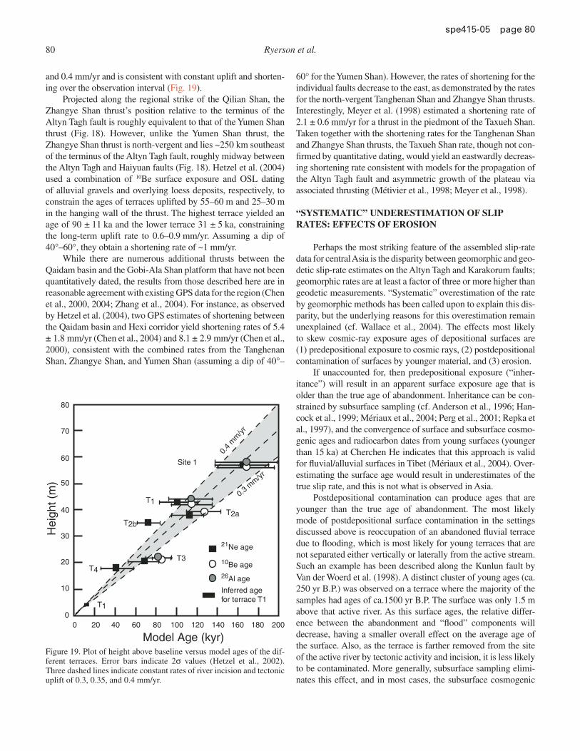
80 Ryerson et al.
spe 415-05 page 80
and 0.4 mm/yr and is consistent with constant uplift and shorten-ing over the observation interval (Fig. 19).
Projected along the regional strike of the Qilian Shan, the Zhangye Shan thrust’s position relative to the terminus of the Altyn Tagh fault is roughly equivalent to that of the Yumen Shan thrust (Fig. 18). However, unlike the Yumen Shan thrust, the Zhangye Shan thrust is north-vergent and lies ~250 km southeast of the terminus of the Altyn Tagh fault, roughly midway between the Altyn Tagh and Haiyuan faults (Fig. 18). Hetzel et al. (2004) used a combination of 10Be surface exposure and OSL dating of alluvial gravels and overlying loess deposits, respectively, to constrain the ages of terraces uplifted by 55–60 m and 25–30 m in the hanging wall of the thrust. The highest terrace yielded an age of 90 ± 11 ka and the lower terrace 31 ± 5 ka, constraining the long-term uplift rate to 0.6–0.9 mm/yr. Assuming a dip of 40°–60°, they obtain a shortening rate of ~1 mm/yr.
While there are numerous additional thrusts between the Qaidam basin and the Gobi-Ala Shan platform that have not been quantitatively dated, the results from those described here are in reasonable agreement with existing GPS data for the region (Chen et al., 2000, 2004; Zhang et al., 2004). For instance, as observed by Hetzel et al. (2004), two GPS estimates of shortening between the Qaidam basin and Hexi corridor yield shortening rates of 5.4 ± 1.8 mm/yr (Chen et al., 2004) and 8.1 ± 2.9 mm/yr (Chen et al., 2000), consistent with the combined rates from the Tanghenan Shan, Zhangye Shan, and Yumen Shan (assuming a dip of 40°–
60° for the Yumen Shan). However, the rates of shortening for the individual faults decrease to the east, as demonstrated by the rates for the north-vergent Tanghenan Shan and Zhangye Shan thrusts. Interestingly, Meyer et al. (1998) estimated a shortening rate of 2.1 ± 0.6 mm/yr for a thrust in the piedmont of the Taxueh Shan. Taken together with the shortening rates for the Tanghenan Shan and Zhangye Shan thrusts, the Taxueh Shan rate, though not con-fi rmed by quantitative dating, would yield an eastwardly decreas-ing shortening rate consistent with models for the propagation of the Altyn Tagh fault and asymmetric growth of the plateau via associated thrusting (Métivier et al., 1998; Meyer et al., 1998).
“SYSTEMATIC” UNDERESTIMATION OF SLIP RATES: EFFECTS OF EROSION
Perhaps the most striking feature of the assembled slip-rate data for central Asia is the disparity between geomorphic and geo-detic slip-rate estimates on the Altyn Tagh and Karakorum faults; geomorphic rates are at least a factor of three or more higher than geodetic measurements. “Systematic” overestimation of the rate by geomorphic methods has been called upon to explain this dis-parity, but the underlying reasons for this overestimation remain unexplained (cf. Wallace et al., 2004). The effects most likely to skew cosmic-ray exposure ages of depositional surfaces are (1) predepositional exposure to cosmic rays, (2) postdepositional contamination of surfaces by younger material, and (3) erosion.
If unaccounted for, then predepositional exposure (“inher-itance”) will result in an apparent surface exposure age that is older than the true age of abandonment. Inheritance can be con-strained by subsurface sampling (cf. Anderson et al., 1996; Han-cock et al., 1999; Mériaux et al., 2004; Perg et al., 2001; Repka et al., 1997), and the convergence of surface and subsurface cosmo-genic ages and radiocarbon dates from young surfaces (younger than 15 ka) at Cherchen He indicates that this approach is valid for fl uvial/alluvial surfaces in Tibet (Mériaux et al., 2004). Over-estimating the surface age would result in underestimates of the true slip rate, and this is not what is observed in Asia.
Postdepositional contamination can produce ages that are younger than the true age of abandonment. The most likely mode of postdepositional surface contamination in the settings discussed above is reoccupation of an abandoned fl uvial terrace due to fl ooding, which is most likely for young terraces that are not separated either vertically or laterally from the active stream. Such an example has been described along the Kunlun fault by Van der Woerd et al. (1998). A distinct cluster of young ages (ca. 250 yr B.P.) was observed on a terrace where the majority of the samples had ages of ca.1500 yr B.P. The surface was only 1.5 m above that active river. As this surface ages, the relative differ-ence between the abandonment and “fl ood” components will decrease, having a smaller overall effect on the average age of the surface. Also, as the terrace is farther removed from the site of the active river by tectonic activity and incision, it is less likely to be contaminated. More generally, subsurface sampling elimi-nates this effect, and in most cases, the subsurface cosmogenic
Figure 19. Plot of height above baseline versus model ages of the dif-ferent terraces. Error bars indicate 2σ values (Hetzel et al., 2002). Three dashed lines indicate constant rates of river incision and tectonic uplift of 0.3, 0.35, and 0.4 mm/yr.
0.4
mm
/yr
0.3 mm/yr
80
70
60
50
40
30
20
10
00 20 40 60 80 100 120 140 160 180 200
Model Age (kyr)
Hei
ght (
m)
Site 1
T2a
T1
T2b
T3T4
T1
21Ne age
10Be age26Al age
Inferred age for terrace T1
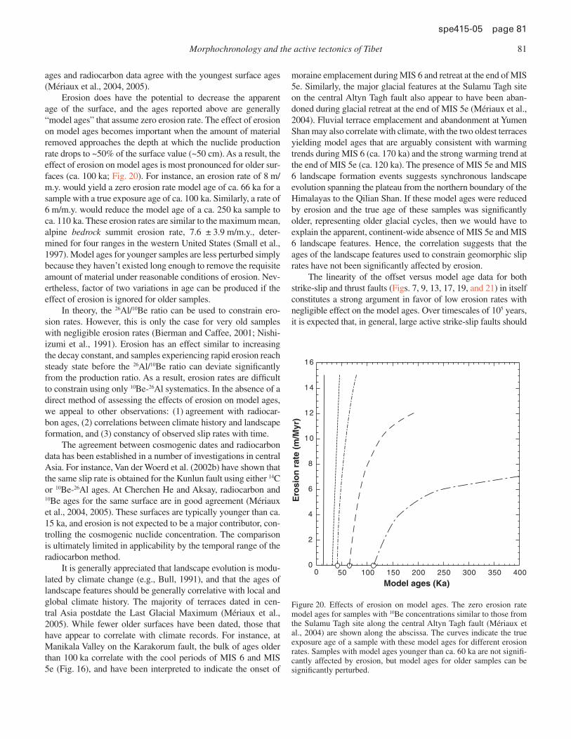
Morphochronology and the active tectonics of Tibet 81
spe 415-05 page 81
ages and radiocarbon data agree with the youngest surface ages (Mériaux et al., 2004, 2005).
Erosion does have the potential to decrease the apparent age of the surface, and the ages reported above are generally “model ages” that assume zero erosion rate. The effect of erosion on model ages becomes important when the amount of material removed approaches the depth at which the nuclide production rate drops to ~50% of the surface value (~50 cm). As a result, the effect of erosion on model ages is most pronounced for older sur-faces (ca. 100 ka; Fig. 20). For instance, an erosion rate of 8 m/m.y. would yield a zero erosion rate model age of ca. 66 ka for a sample with a true exposure age of ca. 100 ka. Similarly, a rate of 6 m/m.y. would reduce the model age of a ca. 250 ka sample to ca. 110 ka. These erosion rates are similar to the maximum mean, alpine bedrock summit erosion rate, 7.6 ± 3.9 m/m.y., deter-mined for four ranges in the western United States (Small et al., 1997). Model ages for younger samples are less perturbed simply because they haven’t existed long enough to remove the requisite amount of material under reasonable conditions of erosion. Nev-ertheless, factor of two variations in age can be produced if the effect of erosion is ignored for older samples.
In theory, the 26Al/10Be ratio can be used to constrain ero-sion rates. However, this is only the case for very old samples with negligible erosion rates (Bierman and Caffee, 2001; Nishi-izumi et al., 1991). Erosion has an effect similar to increasing the decay constant, and samples experiencing rapid erosion reach steady state before the 26Al/10Be ratio can deviate signifi cantly from the production ratio. As a result, erosion rates are diffi cult to constrain using only 10Be-26Al systematics. In the absence of a direct method of assessing the effects of erosion on model ages, we appeal to other observations: (1) agreement with radiocar-bon ages, (2) correlations between climate history and landscape formation, and (3) constancy of observed slip rates with time.
The agreement between cosmogenic dates and radiocarbon data has been established in a number of investigations in central Asia. For instance, Van der Woerd et al. (2002b) have shown that the same slip rate is obtained for the Kunlun fault using either 14C or 10Be-26Al ages. At Cherchen He and Aksay, radiocarbon and 10Be ages for the same surface are in good agreement (Mériaux et al., 2004, 2005). These surfaces are typically younger than ca. 15 ka, and erosion is not expected to be a major contributor, con-trolling the cosmogenic nuclide concentration. The comparison is ultimately limited in applicability by the temporal range of the radiocarbon method.
It is generally appreciated that landscape evolution is modu-lated by climate change (e.g., Bull, 1991), and that the ages of landscape features should be generally correlative with local and global climate history. The majority of terraces dated in cen-tral Asia postdate the Last Glacial Maximum (Mériaux et al., 2005). While fewer older surfaces have been dated, those that have appear to correlate with climate records. For instance, at Manikala Valley on the Karakorum fault, the bulk of ages older than 100 ka correlate with the cool periods of MIS 6 and MIS 5e (Fig. 16), and have been interpreted to indicate the onset of
moraine emplacement during MIS 6 and retreat at the end of MIS 5e. Similarly, the major glacial features at the Sulamu Tagh site on the central Altyn Tagh fault also appear to have been aban-doned during glacial retreat at the end of MIS 5e (Mériaux et al., 2004). Fluvial terrace emplacement and abandonment at Yumen Shan may also correlate with climate, with the two oldest terraces yielding model ages that are arguably consistent with warming trends during MIS 6 (ca. 170 ka) and the strong warming trend at the end of MIS 5e (ca. 120 ka). The presence of MIS 5e and MIS 6 landscape formation events suggests synchronous landscape evolution spanning the plateau from the northern boundary of the Himalayas to the Qilian Shan. If these model ages were reduced by erosion and the true age of these samples was signifi cantly older, representing older glacial cycles, then we would have to explain the apparent, continent-wide absence of MIS 5e and MIS 6 landscape features. Hence, the correlation suggests that the ages of the landscape features used to constrain geomorphic slip rates have not been signifi cantly affected by erosion.
The linearity of the offset versus model age data for both strike-slip and thrust faults (Figs. 7, 9, 13, 17, 19, and 21) in itself constitutes a strong argument in favor of low erosion rates with negligible effect on the model ages. Over timescales of 105 years, it is expected that, in general, large active strike-slip faults should
0 50 100 150 200 250 300 350 4000
2
4
6
8
10
12
14
16
Ero
sio
n r
ate
(m/M
yr)
Model ages (Ka)
Figure 20. Effects of erosion on model ages. The zero erosion rate model ages for samples with 10Be concentrations similar to those from the Sulamu Tagh site along the central Altyn Tagh fault (Mériaux et al., 2004) are shown along the abscissa. The curves indicate the true exposure age of a sample with these model ages for different erosion rates. Samples with model ages younger than ca. 60 ka are not signifi -cantly affected by erosion, but model ages for older samples can be signifi cantly perturbed.
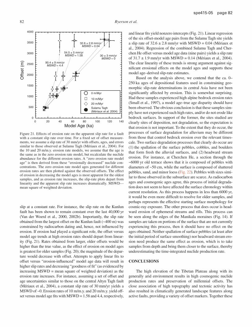
82 Ryerson et al.
spe 415-05 page 82
slip at a constant rate. For instance, the slip rate on the Kunlun fault has been shown to remain constant over the last 40,000 yr (Van der Woerd et al., 2000, 2002b). Importantly, the slip rate obtained from the largest offset on the Kunlun fault (~400 m) was constrained by radiocarbon dating and, hence, not infl uenced by erosion. If erosion had played a signifi cant role, the offset versus model age trends at high erosion rates should depart from linear-ity (Fig. 21). Rates obtained from larger, older offsets would be higher than the true value, as the effect of erosion on model ages is greatest for older samples (Fig. 20); the magnitude of the depar-ture would decrease with offset. Attempts to apply linear fi ts to offset versus “erosion-infl uenced” model age data will result in higher slip rates and decreasing “goodness of fi t” (as evidenced by increasing MSWD = mean square of weighted deviation) as the erosion rate increases. For instance, assuming a set of offset and age uncertainties similar to those on the central Altyn Tagh fault (Mériaux et al., 2004), a constant slip rate of 30 mm/yr yields a MSWD of ~0. Erosion rates of 10 m/m.y. and 20 m/m.y. yield off-set versus model age fi ts with MSWD = 1.58 and 4.4, respectively,
and linear fi ts yield nonzero intercepts (Fig. 21). Linear regression of the six offset-model age pairs from the Sulamu Tagh site yields a slip rate of 32.6 ± 2.8 mm/yr with MSWD = 0.04 (Mériaux et al., 2004). Regression of the combined Sulamu Tagh and Cher-chen He offset versus model age data (nine pairs) yields a slip rate of 31.7 ± 1.9 mm/yr with MSWD = 0.14 (Mériaux et al., 2004). The clear linearity of these trends is strong argument against sig-nifi cant erosional effects on the model ages and supports these model age–derived slip-rate estimates.
Based on the analysis above, we contend that the ca. 0–250 ka ages of depositional features used in constraining geo-morphic slip-rate determinations in central Asia have not been signifi cantly affected by erosion. This is somewhat surprising. Had these samples experienced high alpine bedrock erosion rates (Small et al., 1997), a model age–true age disparity should have been observed. The obvious conclusion is that these samples sim-ply have not experienced such high rates, and/or do not erode like bedrock surfaces. In support of the former, the sites studied are clearly sites of deposition, not degradation, so the expectation is that erosion is not important. To the extent that they do occur, the processes of surface degradation for alluvium may be different from those that control bedrock erosion over the relevant times-cale. Two surface degradation processes that clearly do occur are (1) the spallation of the surface pebbles, cobbles, and boulders that form fresh the alluvial surfaces, and (2) headward stream erosion. For instance, at Cherchen He, a section through the ~6000 yr old terrace shows that it is composed of pebbles with diameters of ~50 cm, while the surface is composed of shattered pebbles, sand, and minor loess (Fig. 22). Pebbles with sizes simi-lar to those observed in the subsurface are scarce. As radiocarbon ages and cosmogenic ages agree, this process of initial degrada-tion does not seem to have affected the surface chronology within current resolution. As this process happens in less than 6000 yr, it would be even more diffi cult to resolve for older samples, and perhaps represents the effective starting surface morphology for cosmic-ray exposure. The other process that does occur is head-ward erosion of ephemeral streams and rills. This process can be seen along the edges of the Manikala moraines (Fig. 14). If samples are taken on portions of the surface that are not currently experiencing this process, then it should have no effect on the ages obtained. Neither spallation of surface pebbles (at least after the initial period of surface smoothing) nor headward stream ero-sion need produce the same effect as erosion, which is to take samples from depth and bring them closer to the surface, thereby underestimating the time-integrated nuclide production rate.
CONCLUSIONS
The high elevation of the Tibetan Plateau along with its generally arid environment results in high cosmogenic nuclide production rates and preservation of millennial offsets. The close association of high topography and tectonic activity has also resulted in climatically generated landscape features along active faults, providing a variety of offset markers. Together these
0
500
1000
1500
2000
2500
3000
3500
4000
Model Age (ka)
Offs
et (
m)
30 ± 3 mm/yrMSWD = 0
32.6 ± 2.8 mm/yrMSWD = 0.04
54.5 ± 5 mm/yrMSWD = 1.58
90.4 ± 9 mm/yrMSWD = 4.4
20 40 8060 100 120 1400
0 m/Myr
10 m/Myr
20 m/Myr
Sulamu Tagh(Mériaux et al. 2004)
Figure 21. Effects of erosion rate on the apparent slip rate for a fault with a constant slip rate over time. For a fi xed set of offset measure-ments, we assume a slip rate of 30 mm/yr with offsets, ages, and errors similar to those observed at Sulamu Tagh (Mériaux et al., 2004). For the 10 and 20 m/m.y. erosion rate models, we assume that the age is the same as in the zero erosion rate model, but recalculate the nuclide abundance for the different erosion rates. A “zero erosion rate model age” is then derived from these “erosionally decreased” nuclide con-centrations. The zero erosion rate model ages generated for different erosion rates are then plotted against the observed offsets. The effect of erosion in decreasing the model ages is most apparent for the oldest samples, and as erosion rate increases, the slip-rate plots depart from linearity and the apparent slip rate increases dramatically. MSWD—mean square of weighted deviation.
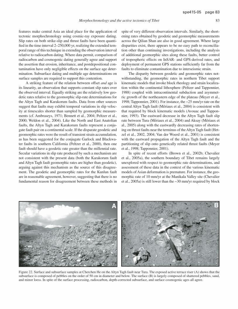
Morphochronology and the active tectonics of Tibet 83
spe 415-05 page 83
features make central Asia an ideal place for the application of tectonic morphochronology using cosmic-ray exposure dating. Slip rates on both strike-slip and thrust faults have been quanti-fi ed in the time interval 2–250,000 yr, realizing the extended tem-poral range of this technique in extending the observation interval relative to radiocarbon dating. Where data permit, comparison of radiocarbon and cosmogenic dating generally agree and support the assertion that erosion, inheritance, and postdepositional con-tamination have only negligible effects on the surface age deter-mination. Subsurface dating and multiple age determinations on surface samples are required to support this contention.
A striking feature of the relation between offset and age is its linearity, an observation that supports constant slip rates over the observed interval. Equally striking are the relatively low geo-detic rates relative to the geomorphic slip-rate determinations for the Altyn Tagh and Karakorum faults. Data from other sources suggest that faults may exhibit temporal variations in slip veloc-ity at timescales shorter than sampled by geomorphic measure-ments (cf. Ambraseys, 1971; Bennett et al., 2004; Peltzer et al., 2000; Weldon et al., 2004). Like the North and East Anatolian faults, the Altyn Tagh and Karakorum faults represent a conju-gate fault pair on a continental scale. If the disparate geodetic and geomorphic rates were the result of transient strain accumulation, as has been suggested for the conjugate Garlock and Blackwa-ter faults in southern California (Peltzer et al., 2000), then one fault should have a geodetic rate greater than the millennial rate. Secular variations in slip rate produced by such a mechanism are not consistent with the present data (both the Karakorum fault and Altyn Tagh fault geomorphic rates are higher than geodetic), arguing against this mechanism as the source of this disagree-ment. The geodetic and geomorphic rates for the Kunlun fault are in reasonable agreement, however, suggesting that there is no fundamental reason for disagreement between these methods in
spite of very different observation intervals. Similarly, the short-ening rates obtained by geodetic and geomorphic measurements across the Qilian Shan are also in good agreement. Where large disparities exist, there appears to be no easy path to reconcilia-tion other than continuing investigations, including the analysis of additional geomorphic sites along these faults, better control of tropospheric effects on InSAR- and GPS-derived rates, and deployment of permanent GPS stations suffi ciently far from the faults to eliminate contamination due to interseismic strain.
The disparity between geodetic and geomorphic rates not-withstanding, the geomorphic rates in northern Tibet support kinematic models that invoke block rheology and strain localiza-tion within the continental lithosphere (Peltzer and Tapponnier, 1988) coupled with intracontinental subduction and asymmet-ric growth of the northeastern edge of the plateau (Meyer et al., 1998; Tapponnier, 2001). For instance, the ~25 mm/yr rate on the central Altyn Tagh fault (Mériaux et al., 2004) is consistent with that required by block kinematic models (Avouac and Tappon-nier, 1993). The eastward decrease in the Altyn Tagh fault slip rate between Tura (Mériaux et al., 2004) and Aksay (Mériaux et al., 2005) along with the eastwardly decreasing rates of shorten-ing on thrust faults near the terminus of the Altyn Tagh fault (Het-zel et al., 2002, 2004; Van der Woerd et al., 2001) is consistent with the eastward propagation of the Altyn Tagh fault and the partitioning of slip onto genetically related thrust faults (Meyer et al., 1998; Tapponnier, 2001).
In spite of recent efforts (Brown et al., 2002b; Chevalier et al., 2005a), the southern boundary of Tibet remains largely unexplored with respect to geomorphic rate determinations, and assessment of these data in the context of the various kinematic models of Asian deformation is premature. For instance, the geo-morphic rate of 10 mm/yr at the Manikala Valley site (Chevalier et al., 2005a) is still lower than the ~30 mm/yr required by block
A B
Figure 22. Surface and subsurface samples at Cherchen He on the Altyn Tagh fault near Tura. The exposed active terrace riser (A) shows that the subsurface is composed of pebbles on the order of 50 cm in diameter and below. The surface (B) is largely composed of shattered pebbles, sand, and minor loess. In spite of the surface processing, radiocarbon, depth-corrected subsurface, and surface cosmogenic ages all agree.
84 Ryerson et al.
spe 415-05 page 84
kinematic models (Avouac and Tapponnier, 1993; Peltzer and Saucier, 1996). Whether this is the result of slip on other, as-yet uninvestigated, strands of the fault remains to be established, as are potential along-strike variations in velocity. In a similar con-nection, the rate of motion along the Karakorum-Jiali fracture zone has not been quantitatively constrained by cosmogenic dat-ing. The role of the Karakorum-Jiali fracture zone in transferring slip from the Karakorum fault to strike-slip faults in eastern Asia, e.g., the Jiali fault, is a critical element of rigid block models of Asian deformation. Given the distributed nature of these features and the more subdued topography, acquisition of these data pres-ents a formidable challenge.
ACKNOWLEDGMENTS
This work was performed under the auspices of the U.S. Depart-ment of Energy by University of California Lawrence Livermore National Laboratory under contract W-7405-Eng-48 under the sponsorship of the Laboratory Directed Research and Develop-ment program (report no. UCRL-BOOK-209322). The work was also supported by Institut National des Sciences de l’Univers, Centre National de la Recherche Scientifi que (Paris, France), through programs Imagerie et Dynamique de la Lithosphère and Intérieur de la Terre, and by the China Earthquake Administra-tion and the Ministry of Lands and Resources (Beijing, China).
REFERENCES CITED
Ambraseys, N.N., 1971, Value of historical record of earthquakes: Nature, v. 232, p. 375–379, doi: 10.1038/232375a0.
Anderson, R.S., Repka, J.L., and Dick, G.S., 1996, Explicit treatment of inheritance in dating depositional surfaces using in situ 10Be and 26Al: Geology, v. 24, p. 47–51, doi: 10.1130/0091-7613(1996)024<0047:ETOIID>2.3.CO;2.
Armijo, R., Tapponnier, P., and Tonglin, H., 1989, Late Cenozoic right-lateral strike-slip faulting in southern Tibet: Journal of Geophysical Research, B, Solid Earth and Planets, v. 94, no. B3, p. 2787–2838.
Avouac, J.P., and Peltzer, G., 1993, Active tectonics in southern Xinjiang, China—Analysis of terrace riser and normal-fault scarp degradation along the Hotan-Qira fault system: Journal of Geophysical Research, B, Solid Earth and Planets, v. 98, no. B12, p. 21,773–21,807.
Avouac, J.P., and Tapponnier, P., 1992, Kinematic model of active deformation in central Asia: Comptes Rendus de l’Academie des Sciences Serie Ii, v. 315, no. 13, p. 1791–1798.
Avouac, J.P., and Tapponnier, P., 1993, Kinematic model of active deformation in central Asia: Geophysical Research Letters, v. 20, no. 10, p. 895–898.
Banerjee, P., and Burgmann, R., 2002, Convergence across the northwest Himalaya from GPS measurements: Geophysical Research Letters, v. 29, no. 13, Art. No. 1652.
Bendick, R., Bilham, R., Freymueller, J., Larson, K., and Yin, G.H., 2000, Geo-detic evidence for a low slip rate in the Altyn Tagh fault system: Nature, v. 404, no. 6773, p. 69–72, doi: 10.1038/35003555.
Bennett, R.A., Friedrich, A.M., and Furlong, K.P., 2004, Codependent histories of the San Andreas and San Jacinto fault zones from inversion of fault displacement rates: Geology, v. 32, p. 961–964, doi: 10.1130/G20806.1.
Bierman, P.R., and Caffee, M.W., 2001, Slow rates of rock surface erosion and sediment production across the Namib Desert and escarpment, southern Africa: American Journal of Science, v. 301, p. 326–358.
Bilham, R., Larson, K., Freymueller, J., Jouanne, F., LeFort, P., Leturmy, P., Mugnier, J.L., Gamond, J.F., Glot, J.P., Martinod, J., Chaudury, N.L., Chi-trakar, G.R., Gautam, U.P., Koirala, B.P., Pandey, M.R., Ranabhat, R., Sap-kota, S.N., Shrestha, P.L., Thakuri, M.C., Timilsina, U.R., Tiwari, D.R., Vidal, G., Vigny, C., Galy, A., and deVoogd, B., 1997, GPS measurements
of present-day convergence across the Nepal Himalaya: Nature, v. 386, no. 6620, p. 61–64, doi: 10.1038/386061a0.
Brown, E.T., Bendick, R., Bourles, D., Gaur, V., Molnar, P., Raisbeck, G.M., and Yiou, F., 2002a, Slip rates of the Karakorum fault, Ladakh, India, deter-mined using cosmic ray exposure dating of debris fl ows and moraines: Journal of Geophysical Research, B, Solid Earth and Planets, v. 107, Art. No. 2192.
Brown, E.T., Bendick, R., Bourles, D.L., Gaur, V., Molnar, P., Raisbeck, G.M., and Yiou, F., 2002b, Slip rates of the Karakorum fault, Ladakh, India, determined using cosmic ray exposure dating of debris fl ows and moraines: Journal of Geophysical Research, B, Solid Earth and Planets, v. 107, no. B9.
Brown, E.T., Molnar, P., and Bourles, D.L., 2005, Comment on “Slip-rate measure-ments on the Karakorum fault may imply secular variations in fault motion”: Science, v. 309, no. 5739, p. 1326, doi: 10.1126/science.1112508.
Bull, W.B., 1991, Geomorphic responses to climatic change: New York, Oxford University Press, 326 p.
Burchfi el, B.C., King, R.W., and Royden, L.H., E., W., Chen, Z., Zhang, X., and Zhao, J., 1998, GPS results from the entire eastern part of the Tibetan Plateau and its adjacent foreland and their tectonic interpretation: Eos (Transactions, American Geophysical Union), v. 79, p. 45 [[Please clar-ify author initials.]].
Chen, Q.Z., Freymueller, J.T., Wang, Q., Yang, Z.Q., Xu, C.J., and Liu, J.N., 2004, A deforming block model for the present-day tectonics of Tibet: Journal of Geophysical Research, B, Solid Earth and Planets, v. 109, no. B1.
Chen, Z., Burchfi el, B.C., Liu, Y., King, R.W., Royden, L.H., Tang, W., Wang, E., Zhao, J., and Zhang, X., 2000, Global positioning system measure-ments from eastern Tibet and their implications for India/Eurasia intercon-tinental deformation: Journal of Geophysical Research, B, Solid Earth and Planets, v. 105, no. B7, p. 16,215–16,227, doi: 10.1029/2000JB900092.
Chevalier, M.-L., Ryerson, F.J., Tapponnier, P., Finkel, R.C., Van der Woerd, J., Haibing, L., and Qing, L., 2005a, Slip-rates measurements on the Kara-korum fault may imply secular variations in fault motion: Science, v. 307, p. 411–414, doi: 10.1126/science.1105466.
Chevalier, M.L., Ryerson, F.J., Tapponnier, P., Finkel, R.C., Van Der Woerd, J., Li, H.B., and Liu, Q., 2005b, Response to comment on “Slip-rate measure-ments on the Karakorum fault may imply secular variations in fault motion”: Science, v. 309, no. 5739, p. 1326, doi: 10.1126/science.1112629.
Cowgill, E., Yin, A., Harrison, T.M., and Wang, X.F., 2003, Reconstruction of the Altyn Tagh fault based on U-Pb geochronology: Role of back thrusts, mantle sutures, and heterogeneous crustal strength in forming the Tibetan Plateau: Journal of Geophysical Research, B, Solid Earth and Planets, v. 108, no. B7.
Cui, Z., and Yang, B., 1979, On the Tuouohu-Maqu active fault zone: North-western Seismological Journal, v. 1, p. 57–61.
Deng, Q.D., 1986, Variations in the geometry and amount of slip on the Hai-yuan (Nanxihaushan) fault zone, China, and the surface rupture of the 1920 Haiyuan earthquake: Earthquake source mechanics, in Das, S., Boatwright, J, and Scholz, C.H., eds.: Washington, D.C., American Geo-physical Union, Geophysical Monograph 37, p. 169–182.
England, P., and Houseman, G., 1986, Finite strain calculations of continental deformation, 2: Comparison with the India-Asia collision zone: Jour-nal of Geophysical Research, B, Solid Earth and Planets, v. 91, no. B3, p. 3664–3676.
England, P., and Molnar, P., 1997a, Active deformation of Asia: From kinemat-ics to dynamics: Science, v. 278, no. 5338, p. 647–650, doi: 10.1126/sci-ence.278.5338.647.
England, P., and Molnar, P., 1997b, The fi eld of crustal velocity in Asia calcu-lated from Quaternary rates of slip on faults: Geophysical Journal Inter-national, v. 130, no. 3, p. 551–582.
Gaudemer, Y., Tapponnier, P., Meyer, B., Peltzer, G., Guo, S.M., Chen, Z.T., Dai, H.G., and Cifuentes, I., 1995, Partitioning of crustal slip between linked, active faults in the eastern Qilian Shan, and evidence for a major seismic gap, the Tianzhu Gap, on the western Haiyuan fault, Gansu (China): Geophysical Journal International, v. 120, no. 3, p. 599–645.
Ge, S., Shen, G., Wei, R., Ding, G., and Wang, Y., 1992, Active Altun fault zone monograph: Beijing, China, State Seismological Bureau of China, 319 p.
Gehrels, G.E., Yin, A., and Wang, X.F., 2003, Detrital-zircon geochronol-ogy of the northeastern Tibetan Plateau: Geological Society of America Bulletin, v. 115, p. 881–896, doi: 10.1130/0016-7606(2003)115<0881:DGOTNT>2.0.CO;2.
Morphochronology and the active tectonics of Tibet 85
spe 415-05 page 85
Gilley, L.D., Harrison, T.M., Leloup, P.H., Ryerson, F.J., Lovera, O.M., and Wang, J.H., 2003, Direct dating of left-lateral deformation along the Red River shear zone, China and Vietnam: Journal of Geophysical Research, v. 108, p. 2127, doi: 10.1029/2001JB001726.
Gu, G., Lin, Tinghaung, and Shi, Zheniliang, 1989, Catalogue of Chinese earth-quakes (1831 BC–1969 AD): Beijing, China, Science Press, 872 p.
Hancock, G.S., Anderson, R.S., Chadwick, O.A., and Finkel, R.C., 1999, Dat-ing fl uvial terraces with Be-10 and Al-26 profi les: Application to the Wind River, Wyoming: Geomorphology, v. 27, no. 1-2, p. 41–60, doi: 10.1016/S0169-555X(98)00089-0.
Herquel, G., Tapponnier, P., Wittlinger, G., Mei, J., and Danian, S., 1999, Tele-seismic shear wave splitting and lithospheric beneath and across the Altyn Tagh fault: Geophysical Research Letters, v. 26, no. 21, p. 3225–3228, doi: 10.1029/1999GL005387.
Hetzel, R., Niedermann, S., Tao, M., Kubik, P.W., Ivy-Ochs, S., Gao, B., and Strecker, M.R., 2002, Low slip rates and long-term preservation of geo-morphic features in central Asia: Nature, v. 417, no. 6887, p. 428–432, doi: 10.1038/417428a.
Hetzel, R., Tao, M.X., Stokes, S., Niedermann, S., Ivy-Ochs, S., Gao, B., Strecker, M.R., and Kubik, P.W., 2004, Late Pleistocene/Holocene slip rate of the Zhangye thrust (Qilian Shan, China) and implications for the active growth of the northeastern Tibetan Plateau: Tectonics, v. 23, no. 6, article TC6006, doi: 10.1029/2004TC001653.
Imbrie, J., Hays, J.D., Martinson, D.G., Mclntyre, A., Mix, A.C., Morley, J.J., Pisias, N.G., Prell, W.L., and Shackleton, N.J., 1984, The orbital theory of Pleistocene climate: Support from a revised chronology of the marine delta 18O record, in Berger, A., et al., eds., Milankovitch and climate, Part I: Boston, Reidel, p. 269–305.
Kidd, W.S.F., and Molnar, P., 1988, Quaternary and active faulting observed on the 1985 Academia-Sinica Royal Society geotraverse of Tibet: Royal Society of London Philosophical Transactions, ser. A, Mathematical Physical and Engineering Sciences, v. 327, no. 1594, p. 337–363.
Lacassin, R., Valli, F., Arnaud, N., Leloup, P.H., Paquette, J.L., Haibing, L., Tapponnier, P., Chevalier, M.L., Guillot, S., Maheo, G., and Xu, Z.Q., 2004, Large-scale geometry, offset and kinematic evolution of the Kara-korum fault, Tibet: Earth and Planetary Science Letters, v. 219, no. 3-4, p. 255–269, doi: 10.1016/S0012-821X(04)00006-8.
Larson, K.M., Burgmann, R., Bilham, R., and Freymueller, J.T., 1999, Kine-matics of the India-Eurasia collision zone from GPS measurements: Jour-nal of Geophysical Research, B, Solid Earth and Planets, v. 104, no. B1, p. 1077–1093, doi: 10.1029/1998JB900043.
Lasserre, C., Morel, P.H., Gaudemer, Y., Tapponnier, P., Ryerson, F.J., King, G.C.P., Metivier, F., Kasser, M., Kashgarian, M., Baichi, L., Taiya, L., and Daoyang, Y., 1999, Postglacial left slip rate and past occurrence of M ≥ 8 earthquakes on the western Haiyuan fault, Gansu, China: Jour-nal of Geophysical Research, B, Solid Earth and Planets, v. 104, no. B8, p. 17,633–17,651, doi: 10.1029/1998JB900082.
Lasserre, C., Gaudemer, Y., Tapponnier, P., Meriaux, A.S., Van der Woerd, J., Yuan, D.Y., Ryerson, F.J., Finkel, R.C., and Caffee, M.W., 2002, Fast late Pleistocene slip rate on the Leng Long Ling segment of the Haiyuan fault, Qinghai, China: Journal of Geophysical Research, B, Solid Earth and Planets, v. 107, no. B11, Art. No. 2276.
Li, L., and Jia, Y., 1981, Characteristics of the deformation band of the 1937 Tuosuohu earthquake (M 7.5) in Qinhai: Northwestern Seismological Journal, v. 3, p. 61–65.
Liu, Q., 1993, Paléoclimat et Contraintes Chronologiques sur les Mouvemonts Récents dans l’Ouest du Tibet: Failles du Karakourm et de Longmu Co-Gozha Co, Lacs en Pull-Apart de Loungmu Co et de Sumxi Co [Ph.D. thesis]: Paris, L’Universite Paris VII, 360 p.
Massonnet, D., Rossi, M., Carmona, C., Adragna, F., Peltzer, G., Feigl, K., and Rabaute, T., 1993, The displacement fi eld of the Landers earthquake mapped by radar interferometry: Nature, v. 364, no. 6433, p. 138–142, doi: 10.1038/364138a0.
Mériaux, A., Ryerson, F.J., Tapponnier, P., Van der Woerd, J., Finkel, R., Xu, X., Xu, Z., and Caffee, M.W., 2004, Rapid slip along the central Altyn Tagh fault: Morphochronologic evidence from Cherchen He and Sulamu Tagh: Journal of Geophysical Research, v. 109, B06401, doi: 10.1029/2003JB002558.
Mériaux, A.S., Tapponnier, P., Ryerson, F.J., Xu, X.W., King, G., Van der Woerd, J., Finkel, R.C., Li, H.B., Caffee, M.W., Xu, Z.Q., and Chen, W.B., 2005, The Aksay segment of the northern Altyn Tagh fault: Tectonic geomorphology, landscape evolution, and Holocene slip rate: Journal of Geophysical Research, B, Solid Earth and Planets, v. 110, no. B4.
Métivier, F., Gaudemer, Y., Tapponnier, P., and Meyer, B., 1998, Northeastward growth of the Tibet Plateau deduced from balanced reconstruction of two depositional areas: The Qaidam and Hexi Corridor basins, China: Tecton-ics, v. 17, no. 6, p. 823–842, doi: 10.1029/98TC02764.
Meyer, B., 1991, Mécanismes des grands tremblements de terre et du rac-courcissement crustal oblique au bord nord-est du Tibet [Ph.D. thesis]: Paris, Université de Paris VII.
Meyer, B., Tapponnier, P., Gaudemer, Y., Peltzer, G., Guo, S.M., and Chen, Z.T., 1996, Rate of left-lateral movement along the easternmost segment of the Altyn Tagh fault, east of 96 degrees E (China): Geophysical Journal International, v. 124, no. 1, p. 29–44.
Meyer, B., Tapponnier, P., Bourjot, L., Metivier, F., Gaudemer, Y., Peltzer, G., Shunmin, G., and Zhitai, C., 1998, Crustal thickening in Gansu-Qinghai, lithospheric mantle subduction, and oblique, strike-slip controlled growth of the Tibet Plateau: Geophysical Journal International, v. 135, no. 1, p. 1–47, doi: 10.1046/j.1365-246X.1998.00567.x.
Molnar, P., and Lyon Caen, H., 1989, Fault plane solutions of earthquakes and active tectonics of the Tibetan Plateau and its margins: Geophysical Jour-nal International, v. 99, no. 1, p. 123–153.
Murphy, M.A., Yin, A., Kapp, P., Harrison, T.M., Manning, C.E., Ryerson, F.J., Ding, L., and Guo, J.H., 2002, Structural evolution of the Gurla Mandhata detachment system, southwest Tibet: Implications for the eastward extent of the Karakoram fault system: Geological Society of America Bulletin, v. 114, p. 428, doi: 10.1130/0016-7606(2002)114<0428:SEOTGM>2.0.CO;2.
Nishiizumi, K., Kohl, C.P., Arnold, J.R., Klein, J., Fink, D., and Middleton, R., 1991, Cosmic ray produced 10Be and 26Al in Antarctic rocks: Exposure and erosion history: Earth and Planetary Science Letters, v. 104, p. 440–454, doi: 10.1016/0012-821X(91)90221-3.
Peltzer, G., and Rosen, P., 1995, Surface displacements of the 17 May 1993 Eureka Valley, California, earthquake observed by SAR interferometry: Science, v. 268, no. 5215, p. 1333–1336.
Peltzer, G., and Saucier, F., 1996, Present-day kinematics of Asia derived from geologic fault rates: Journal of Geophysical Research, B, Solid Earth and Planets, v. 101, no. B12, p. 27,943–27,956, doi: 10.1029/96JB02698.
Peltzer, G., and Tapponnier, P., 1988, Formation and evolution of strike-slip faults, rifts, and basins during the India-Asia collision—An experimental approach: Journal of Geophysical Research, B, Solid Earth and Planets, v. 93, no. B12, p. 15,085–15,117.
Peltzer, G., Tapponnier, P., Gaudemer, Y., Meyer, B., Guo, S.M., Yin, K.L., Chen, Z.T., and Dai, H.G., 1988, Offsets of late Quaternary morphology, rate of slip, and recurrence of large earthquakes on the Chang Ma fault (Gansu, China): Journal of Geophysical Research, B, Solid Earth and Planets, v. 93, no. B7, p. 7793–7812.
Peltzer, G., Tapponnier, P., and Armijo, R., 1989, Magnitude of late Quaternary left-lateral displacements along the north edge of Tibet: Science, v. 246, p. 1285–1289.
Peltzer, G., Hudnut, K.W., and Feigl, K.L., 1994, Analysis of coseismic surface displacement gradients using radar interferometry—New insights into the Landers earthquake: Journal of Geophysical Research, B, Solid Earth and Planets, v. 99, no. B11, p. 21,971–21,981, doi: 10.1029/94JB01888.
Peltzer, G., Crampe, F., and King, G., 1999, Evidence of nonlinear elasticity of the crust from the Mw 7.6 Manyi (Tibet) earthquake: Science, v. 286, no. 5438, p. 272–276, doi: 10.1126/science.286.5438.272.
Peltzer, G., Crampe, F., Hensley, S., and Rosen, P.A., 2000, Transient strain accumulation in the eastern California shear zone: Eos (Transactions, American Geophysical Union), v. 81, p. F1244.
Peltzer, G., Crampe, F., Hensley, S., and Rosen, P., 2001a, Transient strain accumu-lation and fault interaction in the eastern California shear zone: Geology, v. 29, p. 975–978, doi: 10.1130/0091-7613(2001)029<0975:TSAAFI>2.0.CO;2.
Peltzer, G., Crampe, F., and Rosen, P., 2001b, The Mw 7.1, Hector Mine, California earthquake: Surface rupture, surface displacement fi eld, and fault slip solution from ERS SAR data: Comptes Rendus de l’Academie Des Sciences: Paris, Sciences De La Terre et des Planetes, v. 333, no. 9, p. 545–555.
Perg, L.A., Anderson, R.S., and Finkel, R.C., 2002, Use of a new Be-10 and Al-26 inventory method to date marine terraces, Santa Cruz, Cali-fornia, USA: Reply: Geology, v. 29, p. 879–882, doi: 10.1130/0091-7613(2001)029<0879:UOANBA>2.0.CO;2.
Perg, L.A., Anderson, R.S., and Finkel, R.C., 2003, Use of cosmogenic radionuclides as a sediment tracer in the Santa Cruz littoral cell, Cali-fornia, United States: Geology, v. 31, p. 299–302, doi: 10.1130/0091-7613(2003)031<0299:UOCRAA>2.0.CO;2.
86 Ryerson et al.
spe 415-05 page 86
Phillips, R.J., Parrish, R.R., and Searle, M.P., 2004, Age constraints on duc-tile deformation and long-term slip rates along the Karakoram fault zone, Ladakh: Earth and Planetary Science Letters, v. 226, no. 3-4, p. 305–319, doi: 10.1016/j.epsl.2004.07.037.
Repka, J.L., Anderson, R.S., and Finkel, R.C., 1997, Cosmogenic dating of fl u-vial terraces, Fremont River, Utah: Earth and Planetary Science Letters, v. 152, no. 1-4, p. 59–73, doi: 10.1016/S0012-821X(97)00149-0.
Ritts, B.D., and Biffi , U., 2000, Magnitude of post–Middle Jurassic (Bajo-cian) displacement on the Altyn Tagh fault, northwest China: Geologi-cal Society of America Bulletin, v. 112, p. 61–74, doi: 10.1130/0016-7606(2000)112<0061:MOPMJB>2.3.CO;2.
Shen, F., Royden, L.H., and Burchfi el, B.C., 2001a, Large-scale crustal deforma-tion of the Tibetan Plateau: Journal of Geophysical Research, B, Solid Earth and Planets, v. 106, no. B4, p. 6793–6816, doi: 10.1029/2000JB900389.
Shen, Z.K., Wang, M., Li, Y.X., Jackson, D.D., Yin, A., Dong, D.N., and Fang, P., 2001b, Crustal deformation along the Altyn Tagh fault system, western China, from GPS: Journal of Geophysical Research, B, Solid Earth and Planets, v. 106, no. B12, p. 30,607–30,621, doi: 10.1029/2001JB000349.
Sieh, K.E., and Jahns, R.H., 1984, Holocene activity of the San Andreas fault at Wallace Creek, California: Geological Society of America Bulletin, v. 95, p. 883–896, doi: 10.1130/0016-7606(1984)95<883:HAOTSA>2.0.CO;2.
Small, E.E., Anderson, R.S., Repka, J.L., and Finkel, R., 1997, Erosion rates of alpine bedrock summit surfaces deduced from in situ 10Be and 26Al: Earth and Planetary Science Letters v. 150, p. 413–425.
Sobel, E.R., Arnaud, N., Jolivet, M., Ritts, B.D., and Brunel, M., 2001, Juras-sic to Cenozoic exhumation of the Altyn Tagh range, northwest China, constrained by 40Ar/ 39Ar and apatite fi ssion track thermochronology, in Hendrix, M.S., and Davis, G.A., eds., Paleozoic and Mesozoic tectonic evolution of central Asia: From continental assembly to intracontinental deformation: Geological Society of America Memoir 194, p. 247–267.
Tapponnier, P., and Molnar, P., 1977, Active faulting and tectonics in China: Journal of Geophysical Research, v. 82, no. 20, p. 2905.
Tapponnier, P., and Molnar, P., 1979, Active faulting and Cenozoic tectonics of the Tien Shan, Mongolia, and Baykal regions: Journal of Geophysical Research, v. 84, no. B7, p. 3425.
Tapponnier, P., Meyer, B., Avouac, J.P., Peltzer, G., Gaudemer, Y., Guo, S.M., Xiang, H.F., Yin, K.L., Chen, Z.T., Cai, S.H., and Dai, H.G., 1990, Active thrusting and folding in the Qilian-Shan, and decoupling between upper crust and mantle in northeastern Tibet: Earth and Planetary Science Let-ters, v. 97, no. 3-4, p. 382–403, doi: 10.1016/0012-821X(90)90053-Z.
Tapponnier, P., Zhiqin, X., Roger, F., Meyer, B., Arnaud, N., Wittlinger, G., and Jingsui, Y., 2001, Oblique stepwise rise and growth of the Tibet Plateau: Science, v. 294, p. 1671–1677, doi: 10.1126/science.105978.
Van der Woerd, J.W., Ryerson, F.J., Tapponnier, P., Gaudemer, Y., Finkel, R., Meriaux, A.S., Caffee, M., Zhao, G.G., and He, Q.L., 1998, Holocene left-slip rate determined by cosmogenic surface dating on the Xidatan segment of the Kunlun fault (Qinghai, China): Geology, v. 26, p. 695–698, doi: 10.1130/0091-7613(1998)026<0695:HLSRDB>2.3.CO;2.
Van der Woerd, J., Ryerson, F.J., Tapponnier, P., Meriaux, A.S., Gaudemer, Y., Meyer, B., Finkel, R.C., Caffee, M.W., Zhao, G.G., and Xu, Z.Q., 2000, Uniform slip-rate along the Kunlun fault: Implications for seismic behaviour and large-scale tectonics: Geophysical Research Letters, v. 27, no. 16, p. 2353–2356, doi: 10.1029/1999GL011292.
Van der Woerd, J., Xu, X., Li, H.B., Tapponnier, P., Meyer, B., Ryerson, F.J., Meriaux, A.S., and Xu, Z.Q., 2001, Rapid active thrusting along the north-western range front of the Tanghe Nan Shan (western Gansu, China): Journal of Geophysical Research, B, Solid Earth and Planets, v. 106, no. B12, p. 30,475–30,504, doi: 10.1029/2001JB000583.
Van der Woerd, J., Meriaux, A.-S., Klinger, Y., Ryerson, F.J., Gaudemer, Y., and Tapponnier, P., 2002a, The November 14th, 2001, Mw = 7.8 Kokoshili earthquake in northern Tibet (Qinghai Province, China): Seismological Research Letters, v. 73, p. 125–135.
Van der Woerd, J., Tapponnier, P., Ryerson, F.J., Meriaux, A.S., Meyer, B., Gaud-emer, Y., Finkel, R.C., Caffee, M.W., Zhao, G.G., and Xu, Z.Q., 2002b, Uniform postglacial slip-rate along the central 600 km of the Kunlun fault (Tibet), from Al-26, Be-10, and C-14 dating of riser offsets, and climatic origin of the regional morphology: Geophysical Journal International, v. 148, no. 3, p. 356–388, doi: 10.1046/j.1365-246x.2002.01556.x.
Wallace, K., Yin, G.H., and Bilham, R., 2004, Inescapable slow slip on the Altyn Tagh fault: Geophysical Research Letters, v. 31, no. 9, doi: 10.1029/2004GL019724.
Wang, E., 1997, Displacement and timing along the northern strand of the Altyn Tagh fault zone, northern Tibet: Earth and Planetary Science Letters, v. 150, no. 1-2, p. 55–64.
Wang, Q., Zhang, P.Z., Freymueller, J.T., Bilham, R., Larson, K.M., Lai, X., You, X.Z., Niu, Z.J., Wu, J.C., Li, Y.X., Liu, J.N., Yang, Z.Q., and Chen, Q.Z., 2001, Present-day crustal deformation in China constrained by global positioning system measurements: Science, v. 294, no. 5542, p. 574–577, doi: 10.1126/science.1063647.
Wang, Q., Zhang, P.Z., Niu, Z.J., Freymueller, J.T., Lai, X., Li, Y.X., Zhu, W.Y., Liu, J.N., Bilham, R., and Larson, K.M., 2002, Present-day crustal move-ment and tectonic deformation in China continent: Science in China, ser. D, Earth Sciences, v. 45, no. 10, p. 865–874.
Washburn, Z., Arrowsmith, J.R., Forman, S.L., Cowgill, E., Wang, X.F., Zhang, Y.Q., and Chen, Z.L., 2001, Late Holocene earthquake history of the central Altyn Tagh fault, China: Geology, v. 29, p. 1051–1054, doi: 10.1130/0091-7613(2001)029<1051:LHEHOT>2.0.CO;2.
Weldon, R., Scharer, K., Fumal, T., and Biasi, G., 2004, Wrightwood and the earthquake cycle: What a long recurrence record tells us about how faults work: GSA Today, v. 14, no. 9, p. 4–10, doi: 10.1130/1052-5173(2004)014<4:WATECW>2.0.CO;2.
Weldon, R.J., and Sieh, K.E., 1985, Holocene rate of slip and tentative recur-rence interval for large earthquakes on the San Andreas fault, Cajon Pass, southern California: Geological Society of America Bulletin, v. 96, p. 793–812, doi: 10.1130/0016-7606(1985)96<793:HROSAT>2.0.CO;2.
Wittlinger, G., Tapponnier, P., Poupinet, G., Mei, J., Danian, S., Herquel, G., and Masson, F., 1998, Tomographic evidence for localized lithospheric shear along the Altyn Tagh fault: Science, v. 282, no. 5386, p. 74–76, doi: 10.1126/science.282.5386.74.
Wittlinger, G., Vergne, J., Tapponnier, P., Farra, V., Poupinet, G., Jiang, M., Su, H., Herquel, G., and Paul, A., 2004, Teleseismic imaging of subduct-ing lithosphere and Moho offsets beneath western Tibet: Earth and Plan-etary Science Letters, v. 221, no. 1-4, p. 117–130.
Wright, T.J., Parsons, B., England, P.C., and Fielding, E.J., 2004, InSAR obser-vations of low slip rates on the major faults of western Tibet: Science, v. 305, no. 5681, p. 236–239, doi: 10.1126/science.1096388.
Xu, X.W., Tapponnier, P., Van Der Woerd, J., Ryerson, F.J., Wang, F., Zheng, R.Z., Chen, W.B., Ma, W.T., Yu, G.H., Chen, G.H., and Meriaux, A.S., 2005, Late Quaternary sinistral slip rate along the Altyn Tagh fault and its structural transformation model: Science in China, ser. D, Earth Sciences, v. 48, no. 3, p. 384–397.
Yang, J., Xu, Z., Zhang, J., Chu, C.-Y., Zhang, R., and Liou, J.G., 2001, Tectonic signifi cance of early Paleozoic high-pressure rock in the Altun-Qaidam-Qilian Mountains, northwest China, in Hendrix, M.S., and Davis, G.A., eds., Paleozoic and Mesozoic tectonic evolution of central Asia: From continental assembly to intracontinental deformation: Geological Society of America Memoir 194, p. 151–170.
Yin, A., Harrison, T.M., Ryerson, F.J., Chen, W.J., Kidd, W.S.F., and Cope-land, P., 1994, Tertiary structural evolution of the Gangdese thrust system, southeastern Tibet: Journal of Geophysical Research, B, Solid Earth and Planets, v. 99, no. B9, p. 18,175–18,201, doi: 10.1029/94JB00504.
Yin, A., Rumelhart, P.E., Butler, R., Cowgill, E., Harrison, T.M., Foster, D.A., Ingersoll, R.V., Zhang, Q., Zhou, X.Q., Wang, X.F., Hanson, A., and Raza, A., 2002, Tectonic history of the Altyn Tagh fault system in northern Tibet inferred from Cenozoic sedimentation: Geological Society of America Bulletin, v. 114, p. 1257–1295, doi: 10.1130/0016-7606(2002)114<1257:THOTAT>2.0.CO;2.
Yue, Y.J., Ritts, B.D., and Graham, S.A., 2001, Initiation and long-term slip his-tory of the Altyn Tagh fault: International Geology Review, v. 43, no. 12, p. 1087–1093.
Zhang, P., Molnar, P., Burchfi el, B.C., Royden, L., Wang, Y., Deng, Q., and Song, F., 1988, Bounds on the Holocene slip-rate on the Haiyuan fault, north-central China: Quaternary Research, v. 30, p. 151–164, doi: 10.1016/0033-5894(88)90020-8.
Zhang, P.Z., Shen, Z., Wang, M., Gan, W.J., Bürgmann, R., and Molnar, P., 2004, Continuous deformation of the Tibetan Plateau from global posi-tioning system data: Geology, v. 32, p. 809–812.
Zhang, W.Q., Jiao, D.C., Zhang, P.Z., Molnar, P., Burchfi el, B.C., Deng, Q.D., Wang, Y.P., and Song, F.M., 1987, Displacement along the Haiyuan fault associated with the Great 1920 Haiyuan, China, earthquake: Bulletin of the Seismological Society of America, v. 77, no. 1, p. 117–131.
MANUSCRIPT ACCEPTED BY THE SOCIETY 11 APRIL 2006
Printed in the USA