Embed Size (px)
Citation preview

September 2002 Development of conservation criteria for Brigalow Belt South bioregion (WRA36)
Page 1
AAPPPPEENNDDIICCIIEESS DDEEVVEELLOOPPMMEENNTT OOFF
CCOONNSSEERRVVAATTIIOONN CCRRIITTEERRIIAA
FFOORR BBRRIIGGAALLOOWW BBEELLTT SSOOUUTTHH
BBIIOORREEGGIIOONN NNSSWW WWEESSTTEERRNN RREEGGIIOONNAALL AASSSSEESSSSMMEENNTTSS FFIINNAALL SSEEPPTTEEMMBBEERR,, 22000022
Resource and Conservation AssesCouncil
Brigalow Belt South
Stage 2

September 2002 Development of conservation criteria for Brigalow Belt South bioregion (WRA36)
Page 2
This blank page has been inserted here so the title page
appears on the right hand side in double-sided printing.

September 2002 Development of conservation criteria for Brigalow Belt South bioregion (WRA36)
Page 3
Appendix 1.1 Briefing for the email/fax panel, and response summary
A regional assessment is currently underway in the NSW part of the Brigalow Belt South bioregion (mid-west NSW). This region of around 5¼ million hectares roughly covers land north from Dubbo to Merriwa, meeting the Queensland border near Yetman. It is being undertaken as a whole-of government exercise in partnership with the community.
A key component of the assessment process is to develop criteria that can be used to provide for conservation of natural values across the landscape through land management decision-making. One of the more immediate uses of the outputs will be consideration later this year of management options for the lands directly managed by government agencies, such as National Park, State forest.
The Conservation Criteria project has commenced to develop these criteria. Its emphasis is:
i) identifying those conservation values which are important for protection in the bioregion (e.g. habitat for woodland birds);
ii) identifying the desired objectives with respect to those values;
iii) developing indicators for those objectives;
iv) developing a strategy for protecting those values in the bioregion over time, which will include innovative approaches to conservation management on public and private land;
v) developing a monitoring program with appropriate indicators showing the improvement in management and protection of conservation values over time; and
vi) structuring the analysis of conservation values in such a way that they readily allow comparison to economic and social values in the bioregion.
The deadline for the draft report is mid-July, necessitating tight timelines for all components of the project. With this in mind the project has been structured with the following key steps:
1. Compiling applicable objectives, values, criteria and strategies.
2. These will be forwarded to a broad group of people (stakeholders and experts), seeking responses and contributions, and in particular regarding:
− Known ecological thresholds,
− How to assess and quantify each criteria,
− How to combine measures to quantify relativity of each value.
3. Responses will be workshopped by experts to arrive at recommendations for a draft report. The workshopping will also consider spatial and temporal rule sets, analytical techniques and reporting, and (to enable the computer software to function) numeric indicators.
4. The workshop recommendations will be circulated widely for review.
5. Responses will be addressed in producing a final report. Linkages will be built with the bioregional landscape conservation framework project, and final outcomes provided as input for subsequent land management considerations and monitoring regimes.
A crucial element in this process is capturing a broad range of thought from technical representatives and experts to provide a sound basis for the workshops. This would allow the workshops, which of necessity will have limited numbers of attendees, to get down to business quickly. The challenge is that very little time is available for comment, and contributions would be greatly appreciated even if they are rushed or are not as detailed as contributors might prefer.

September 2002 Development of conservation criteria for Brigalow Belt South bioregion (WRA36)
Page 4
Communication using e-mail/fax is the most efficient way to engage people for this part of the project. People can devote as much or little time as they have available in their busy schedules. Responses need not be polished or comprehensive. People can refer aspects to others as they see fit. The only proviso is that all correspondence be treated as work in progress and treated with confidentiality.
The tight timeframe for the project provides a real constraint on time available for comment. Whilst detailed review of outcomes is provided further into the project, early comment now will definitely help, by giving the project more time to address issues and pursue initiatives.
Participation is being sought from stakeholder technical representatives and a range of experts, hence this approach to you. I would be delighted and grateful if you could find the time to help with this. Feel free to call me to discuss any aspect of it.
Should you choose not to participate, simply ignore this.
To participate, please provide a response to me by 9:00am this Friday 24th May as follows.
Regarding the attached paper, for Brigalow Belt South bioregion (NSW part):
• Comment if desired on the approach taken and the criteria nominated in the paper.
• Contribute known critical ecological thresholds relevant to persistence of biodiversity, natural and cultural heritage values across the BBS landscape.
• Suggest ways to measure and report each criteria.
• Suggest how the criteria for each value can be combined to quantify and report a relative “score” for each value.
The contributions will be coalesced in a report to be used as input for the workshops. Contributors will receive a copy of the report.
The paper is a draft, for discussion only, and has received no formal endorsement. I would appreciate you being circumspect in dealing with its distribution.
Thanks.
Warwick Bratby
Project Manager - conservation criteria
Resource and Conservation Division
Ph: (02) 9762 8198 Fax: (02) 9762 8712 Email: [email protected]
Level 5, Henry Deane Building, 20 Lee St, Sydney NSW 2000
September 2002 Development of conservation criteria for Brigalow Belt South bioregion (WRA36)
Page 5
Response summary
Responses to the draft paper
The discussion paper was sent to 16 stakeholder technical representatives, 32 experts (selected through the Integration Technical Working Group) and working group members. The turn around time nominated was 4 days. 24 responses were received – 2 did not comment on the paper, 5 supported the approach outlined in the paper, 12 did not overtly support or criticise the approach, and 5 whilst not overtly criticising the approach did express concern that the paper did not cover what they expected. It is expected that the workshop would develop aspects of the paper and would address the essence of many of those concerns. 11 responses offered general comment not requiring action, 16 offered relatively minor refinement that was incorporated into the revised paper, and 11 raised issues warranting referral to the workshop. The issues taken to the workshop are:
1. A number of responses were critical of the technical language and confusing expression throughout the document. This is accepted, and effort will be directed to substantial improvement in the document put out for review.
Expert Workshop – These comments were noted by the Expert workshop.
2. Many straight forward refinements were offered, and these have been incorporated into the paper for the workshop.
Expert Workshop – The changes incorporated into the paper were made available to the workshop and included in discussion.
3. Early discussion relating to Aboriginal aspects has occurred, and a first-cut draft is also in the revised paper.
Expert Workshop – The Experts agreed that their areas of expertise lay in ecology, biology and land management, and that a separate group of experts was needed to discuss criteria for these values.
4. Some respondents felt the paper addressed the issues reasonably well, whilst others expressed disappointment that it did not address the issues of targets (which will be addressed through “numeric indicators” in the workshop) or specific operational/strategic conservation actions (which are at this stage seem beyond the scope of the project).
Expert Workshop – For each criteria the applicability of “numeric indicators” was discussed but the Experts agreed that setting of numeric indicators was beyond the brief of the workshop. However, under Certainty of Conservation Management criteria, the workshop accepted that JANIS would be the basis for making public land decisions and that the targets in JANIS would be used as “numeric indicators” in C-Plan to assist making those decisions.
5. A range of issues emerged that the workshop should consider in its work:
• All outcomes of the workshop should be in concise non-technical terms
Expert Workshop – Noted by the Workshop.
• Populate table 1 – vegetation condition classes
Expert Workshop – This was seen as a very important criteria for the BBS, and a high priority was placed on developing benchmarks for condition by vegetation grouping and geomorphological unit. It was agreed that although not possible to build the benchmarks by September 2002, a workshop should be arranged to develop a condition rating with the view to producing a “potential condition” map for use by CMBs and NVMCs in planning for rehabilitation and revegetation.
September 2002 Development of conservation criteria for Brigalow Belt South bioregion (WRA36)
Page 6
• Work on criteria for Landscape Health value to be clear and purposeful
Expert Workshop – The workshop agreed that the value would be better named “Landscape Function and Sustainability”. A number of criteria were agreed on under Landscape Process, Landscape Pattern, Management Practices and Impact of Exotics. For many of the criteria data will not be available for September 2002 but they provide the basis for measuring and reporting on landscape function and enabling management practices to improve the sustainability of landscapes. Criteria for Certainty of Conservation Management is also included under the Management Practices section of this value. The criteria includes those derived from the JANIS Criteria which will be used to assist public land decisions.
• Define “ecosystem” and “ecosystem function” (the draft paper uses “vegetation grouping as a defacto ecosystem)
Expert Workshop – The workshop did not provide definitions. However, the project report has a definitions section and will provide definitions for technical terms.
• Are the following adequately addressed? Grasslands, aquatic systems, hydrogeology
Expert Workshop – The workshop considered the function of all landscapes and included criteria addressing river health, surface water, groundwater, energy and nutrient flows, connectivity and patch characteristics, successional stages. Although the emphasis of decision making in September 2002 will be on forested lands and woodlands, the criteria forms the basis for measuring and reporting on all landscapes in the bioregion.
• Spatial/temporal rules – consider the Mackey/Nix report to NPWS
Expert Workshop – The workshop was made aware of the Mackey/Nix report. As the report is not yet published the Group felt unable to endorse the adoption of the spatial/temporal rules put forward in the paper for the BBS.
• Explore linking with the criteria being developed by the expert panel advising ESS project
Expert Workshop – Not explored at the workshop. Will be followed up with the respondent.
• Reserve design – need to consider also that for wilderness and late-mature growth stage in high certainty reserve that with the fragmented landscape these may provide a physical barrier isolating populations of species that depend on seral changes
Expert Workshop – This was discussed at the workshop and agreed (and noted in the workshop report for the benefit of reserve design efforts in the deliberations) that the community had an expectation that criteria would be included for wilderness and late mature growth stage vegetation, and that ecologists also recognise their value. Accordingly, criteria has been included for both.
• The base for consideration of conservation outcomes should be the best for biodiversity that we can get rather than “1750”
Expert Workshop – The vegetation mapping project has used predicted potential distribution of native vegetation be vegetation grouping, rather than “Pre-1750”. This will be used as the base layer for comparing what is there today to what there is the potential for. This is only one of the criteria discussed by the Group and others are aimed at landscape function and sustainability.
• See parameters from existing policy documents (pages 11-14 of the project spec)
Expert Workshop – Parameters from existing documents have been considered prior to and during the workshop. Those which are applicable to the BBS have been incorporated into the criteria.
• How do we handle reserve design principles in the process? (page 9 of the project spec)
September 2002 Development of conservation criteria for Brigalow Belt South bioregion (WRA36)
Page 7
Expert Workshop – Reserve design principles will be used as guidelines when making public land decisions.
• Can we bring TSRs into the forefront of conservation initiatives
Expert Workshop – Travelling Stock Routes were not discussed specifically at the workshop but their value in terms of conservation initiatives is recognised in the Western Regional Assessments. TSRs will not be “negotiable” Crown tenures during the Options Development and Recommendations stage, but recommendations about the best way to manage conservation values on TSRs on a landscape basis will be made.
• How to evaluate the criteria and values – one respondent suggested a series of rankings for each criteria to help prioritise strategic responses. Is this useful for this project?
Expert Workshop – Although this was discussed at the workshop, the Group thought it beyond the scope of the workshop and should be pursed as part of the Options Development and recommendations stage.
• Adequacy – some of the criteria have clauses that imply judgement of “adequacy” of an aspect. Any such cases need definitions of just what is meant.
Expert Workshop – Generally, the clauses developed by the workshop avoid use of the term adequacy. Adequacy is used in reference to the CAR (Comprehensive, Adequate, Representative) reserve system. There was general agreement at the workshop that reserves alone were not the way to achieve conservation objectives in the BBS. The relatively small amount of public land in the bioregion (15%) prevents any reserve system from being adequate to conserve biodiversity, hance the emphasis on private land conservation incentives in this bioregion.
• Consider a measure of response to management regime for vegetation groups, based on their ecological characteristics (analogous to "vulnerability" scores used in coastal CRAs, although that is not an appropriate term to use) and a measure of ecological distinctiveness for each group. For each vegetation group we could use area in management regime/intensity classes with a response to regime and distinctiveness modifier for each group to develop an overall score to measure the effects of different conservation options. We do have some data from the vegetation surveys to support the development of these types of scores, provided we can reach consensus on how to use it.
Expert Workshop – Vulnerability was identified by the Group as a value in its own right for the BBS and a criterion was developed for it. Data on some of the key threats will be available for inclusion in the Bioregional Landscape Conservation Framework project.
• For criteria Certainty of conservation management, Habitat of particular quality
- Need tight definitions, otherwise every patch of good condition vegetation might qualify
- Species are dynamic, so we need to be very clear what this seeks to achieve in ecological terms
- Need to be mindful that a high diversity of species might be there because of specific habitat elements, OR that the area is simply an intersection of interlacing but not particularly threatened habitats.
Expert Workshop – Not discussed at the workshop. This should be addressed in the project report.

September 2002 Development of conservation criteria for Brigalow Belt South bioregion (WRA36)
Page 8
This blank page has been inserted here so the next section
appears on the right hand side in double-sided printing.
September 2002 Development of conservation criteria for Brigalow Belt South bioregion (WRA36)
Page 9
Appendix 1.2 Conservation criteria workshop briefing notes, and workshop report
Conservation Criteria Workshop Throughout the process:
− Specify definitions and assumptions where relevant.
− Document briefly the basis/precision/confidence to support the approach taken.
− For each element, provide an explanation of its basis and caveats/limitations, and relevant definitions/assumptions. This will help users avoid taking the output beyond its limitations, and will help subsequent processes identify needs of data collection and analysis to improve reporting in regard to real ecological outcomes.
− Where consensus is not likely, provide alternatives or a range to the extent possible, and an action plan to resolve it.
− Given the very limited time frame, the aim is to develop pragmatic ecologically-based outcomes using the collective expertise of participants (rather than organisational positions).
For Brigalow Belt South bioregion (NSW part), and based on the values/objectives/criteria paper and contributions from the e-mail/fax group:
For each value:
• Review the criteria. Will they properly report the value? Any additions, deletions, or refinements?
• For each criteria, might it be possible to apply in the deliberations in August this year?
− If no, document why and what needs to be done to enable it beyond the deliberations, and pass to the next criteria.
− If yes, document assumed data requirements whilst addressing the following.
• Would a spatial/temporal rule set benefiting conservation outcomes for the criteria under this value be achievable and appropriate for this criteria? If so:
− Formulate the rule set and define analytical techniques based on anticipated data sets and software tools, and provide an explanation of its basis and caveats/limitations, and relevant definitions/assumptions. OR
− Acknowledge why it was not pursued.
• How to measure and report the criteria under this value.
− How to assess each criteria (data and techniques).
− How to analyse available data and report each criteria.
− Consider the relationship to C-plan input/output capabilities and define the needs (if any) for additional modules for analysis/reporting.
• Consider incorporation of known ecological thresholds where appropriate.
• C-plan can calculate an index of importance (“irreplacability”) of each “planning unit” for satisfying a set of criteria. To do this it needs a numeric indicator for each criteria chosen for contribution to this index. Choose the set of criteria for this index, then recommend a numeric indicator for each, being a nominal representation of what might be useful to optimise conser-
September 2002 Development of conservation criteria for Brigalow Belt South bioregion (WRA36)
Page 10
vation improvement out of the BBS deliberations. Where an indicator is agreed as needing to be different between landscape scale consideration and land managed by the Crown, provide a number for each. For each other criteria, recommend an objective (eg “maximise”, “minimise”) and how to enable it to pursue conservation improvement during the BBS deliberations.
• Specify how to combine this value’s criteria and report its “score”.
Roles: Facilitator – seek continual progress through each item, insist on clarity and objectivity. Secure consensus, or draw out the relevant positions/issues where agreement is not readily forthcoming. Keep the workshop moving so each criteria and value are covered.
Experts – contribute expert opinion to assist progressing each item, and strive for consensus (ie a coarse outcome seems better than no outcome).
Agency Reps – offer advice to the experts and facilitator regarding data, software, policy, process, etc., and seek clarification, contribute opinion to the workshop.
Project Manager – as for agency reps.
John Ross – document the proceedings.
September 2002 Development of conservation criteria for Brigalow Belt South bioregion (WRA36)
Page 11
Workshop report Conservation Criteria Expert Workshop Brigalow Belt South Western Regional Assessment
Mercure Hotel – Sydney 28 – 29 May 2002 Attendees: Experts: David Goldney – Environmental Consultant / Charles Sturt University David Read – Environmental Consultant
Denis Saunders – Environmental Consultant (formerly CSIRO) Doug Binns – State Forests of NSW Ian Oliver – Department of Land and Water Conservation Pat Tap – State Forests of NSW (day 2 only) Peter Smith – Department of Land and Water Conservation Phil Cameron – Western Plains Zoo
Facilitator: Ros Muston – Meyrick and Associates
Agency Gary Saunders – NPWS (not present 1st session (day 1) or last session (day 2))
Reps: Pat Groenhout – SFNSW (day 1 only) Ric Noble – Planning NSW (RACD) (day 1 only) Project Manager: Warwick Bratby – Planning NSW (RACD)
Recorder: John Ross – Planning NSW (RACD)
INTRODUCTION The Brigalow Belt South Western Regional Assessment is an interagency study of the Brigalow Belt South bioregion overseen by the Resource and Conservation Assessment Council (RACAC). The assessment draws together existing information and new information from RACAC funded projects to enable decisions and recommendations to be made on the future management of the bioregion’s natural resources. The assessment has conservation, land management, cultural heritage, economic and social objectives.
This workshop brought together experts in ecology and land management, and NSW government policy officers to assist the development of conservation criteria for the bioregion. A discussion paper (Attachment A) was prepared by the project manager and circulated for comment by a wide range of experts in ecology, land management, biology, and other scientific fields. The paper was also circulated to Stakeholder technical Representatives and agency representatives for comment. Twenty four responses were received, and the comments/issues were contributed to the workshop
The workshop aimed to:
• Confirm the range of conservation values that should be addressed in developing conservation criteria for the BBS
• Identify suitable criteria for each value
• Identify how each criterion should be measured and the data required
• Determine how each criterion should be reported
• Whether it was possible to use the criteria in deliberations in September (the options development and recommendations phase of the assessment) for the bioregion, or whether there was insufficient data to enable this to be done
• For those criteria that could be used in the deliberations, which would beneficially be used in C-plan
• For those criteria that are not possible to use in the deliberations, document the reasons and recommend how to deal with the criteria.
September 2002 Development of conservation criteria for Brigalow Belt South bioregion (WRA36)
Page 12
PROCEEDINGS
Confirmation of Values
The primary conservation values proposed in the discussion paper were:
A. Extent, condition and diversity of native vegetation
B. Natural cultural heritage – cultural heritage as it relates to the natural environment, including natural resources culturally significant to Aboriginal communities (e.g. fauna for hunting, plants for bush medicine / bush tucker, ceremonial elements)
C. A healthy landscape (ecosystem function, landscape mosaic and linkages).
D. Historical / archaeological places that are within “natural” environments and that are subject to degradation through natural processes or whose character is tied to the surrounding land.
E. The security of species, particularly those known to be facing extinction.
F. Certainty that appropriate management for conservation will persist, particularly over areas with features that are especially sensitive to human development (e.g. wilder-ness characteristics) or are especially rare (e.g. very restricted vegetation groupings).
G. Overarching temporal processes that guide expression of these values.
Discussion
The experts discussed the primary conservation values and agreed that their areas of expertise qualified them to comment on values relating to biodiversity only. It was agreed that the workshop did not have the expertise to deal with values relating to natural cultural heritage and historical / archaeological places as they relate to natural environments, and that other appropriate experts should address those conservation values. The experts also identified early in the workshop that environmental, cultural, economic and social aspects are inexorably linked, but as there were other projects in the Western Regional Assessment which dealt specifically with these aspects, that the workshop would focus on the biodiversity aspects of the landscape.
The workshop also agreed that the remaining values (A, C, E, F and G as they were stated in the discussion paper) were an acceptable set of conservation values for the experts to consider, and that they adequately covered the range of biodiversity values in the bioregion. It was decided that those values would be the starting point for the workshop. It was recognised though, that as the workshop evolved, some values would also evolve and the criteria beneath them may alter. As the group proceeded through each value the overlaps between values as well as the distinctions between them were identified and attempts were made to reduce these overlaps in the criteria that were developed. Where this has occurred it has been recorded under the value discussed as well as in the summary at the end of the report.
There was a discussion on the scope of what the experts were being asked to address in relation to values being considered. It was agreed that criteria needed to be identified for the whole bioregion and not just the area of public land for which decisions on tenure and management would be made in September 2002. The group felt that, for conservation objectives to be met in the bioregion the criteria needed to cover private (including leasehold) land as well as Crown tenures, and that reserves alone were not adequate to protect conservation values.
Explanations were also given by NPWS of the two conservation decision support tools (C-Plan and Bioregional Landscape Conservation Framework) planned for use during the Options Development and Recommendations stage of the Western Regional Assessment. In providing advice on criteria the Group also considered how these tools might be used to represent each criterion recommended. There was agreement among the group that they should not be setting targets for each criterion as it was inappropriate to do this for most criteria across the bioregion.
September 2002 Development of conservation criteria for Brigalow Belt South bioregion (WRA36)
Page 13
During the workshop, aspects worthy of further development were classified as “critical” or “important”. “Critical” is used where the aspect is vital for proper understanding of the functioning of the ecosystems and landscape, and the workshop considered that development is very high priority. “Important” is used where the aspect makes an important contribution to understanding of the functioning of the ecosystems and landscape, and the workshop considered that development should be pursued.
Value: Extent, Condition, Diversity of Native Vegetation
Extent
Discussion The workshop discussed the concepts of extent, condition and diversity and whether there were any other factors that should be included under this value. The experts agreed that for criteria to be developed for this value a starting point for measuring extent, condition and diversity was needed. Options discussed included:
• map of the Pre-1750 extent of native vegetation so that a comparison can be made between pre European settlement and present. The term “pre-1750” was rejected because it implies knowledge which does not exist, and the concept of pre-1750 vegetation was rejected as not being appropriate for current management of biodiversity conservation.
• map of the current vegetation groupings1 and begin to measure change from now. This was accepted as a basic value but only in relation to predicted extent of vegetation groupings. Its use in isolation was rejected because clearing has been highly biased to particular vegetation groupings, and also that the value of currently extensive vegetation groupings may be underrated.
• map of potential vegetation predicted from relationships between existing vegetation and soil and other physical environmental variables. This was agreed as essential for adequate assessing of existing vegetation.
There was also agreement that the distribution of native vegetation in the landscape should be identified by landscape units based on geomorphology or other environmental domains so as to get an indication of the relationship between groups in the landscape. This would for example help to prevent trade-offs between hilltops and valley floors.
Suggestions were also made that “rate of change”, “tenure” and “extent and history of land use” were issues which could also be considered under this value. The decision was made that they would be more relevant in the Healthy Landscape value, and that they could be revisited under this value if it was found that they should not be included there.
The workshop agreed on the following criteria for “Extent”:
Criterion: The amount of existing native vegetation in relation to the predicted potential distribution of native vegetation by vegetation grouping and by geomporphic / environmental unit.
Data required: - predicted potential distribution of native vegetation (by grouping)
- existing native vegetation (by grouping)
- geomorphic / environmental units
Reporting: - at bioregional scale
- existing vegetation: area, and proportion of predicted (by vegetation grouping and geomorph / environmental unit)
1 The experts agreed to use the term “groupings” as it is as yet unclear what the final nature of the vegetation mapping groups will be (e.g. communities, associations, assemblages) .
September 2002 Development of conservation criteria for Brigalow Belt South bioregion (WRA36)
Page 14
- areal % native vegetation in each geomorphic / environmental unit
- rate of change in existing vegetation area
Possible by September 2002:
Existing: Yes, data available from Western Regional Assessment projects and existing data sets. Geomorphic units are not available across the bioregion, and a coarse environmental domain layer could be generated for the deliberations. The workshop did not ascribe a priority to region-wide geomorphic mapping.
Rate of change: No. Data not available. This will become available if monitoring this criterion is implemented.
C-Plan: A fundamental element for C-plan
Bioregional Framework:
No direct interaction was proposed
Ecological Thresholds:
Clearing more than 30% and 70% of a landscape
Condition
The experts saw that “condition” needed some context before meaningful criteria could be developed for it. Various views included:
• in the absence of other information, tenure may be a surrogate giving a coarse indication of condition
• not all management necessarily leads to degradation of condition (e.g. Cypress pine management)
• a surrogate, such as structure and floristics, is needed to give us condition
• a benchmark needs to be set so that current condition can be compared to the benchmark
• sustainability and restorability could be contained in the benchmark set
• structure and floristics should also be built into the benchmarks
• the spatial distribution of condition is also important
• condition information will assist in setting priorities for reserve selection decisions.
The group determined that it was critical to build benchmarks for vegetation condition so that current condition can be measured against those benchmarks. It was agreed that structure, floristics, and measures of sustainability and restorability should be built into the benchmarks. The group believed that a preliminary version might be possible by September 2002. [This would involve developing benchmarks for over 40 vegetation groupings, relating this to plot data to generate a condition score for each plot, then analysing these against vegetation groupings and geomorphic/environmental units. The vegetation groupings were not resolved at the time of the workshop, and the work may be held up till that is finalised. Availability of suitable experts at that time is unlikely. It was recognised that the spatial distribution would only be at a very coarse scale by that time.] Comments were also made that it may be better to describe restorability than represent it spatially.
The group agreed that persistence and vulnerability should be captured elsewhere in the workshop.
The workshop agreed on the following criteria:
September 2002 Development of conservation criteria for Brigalow Belt South bioregion (WRA36)
Page 15
Criterion: The area of existing native vegetation by condition classes (as defined in relation to ecological benchmarks and restorability classification) by vegetation grouping and by geomporphic / environmental unit.
Data required: - native vegetation ecological benchmarks (including structure, floristics, and function) and a restorability classification system)
- spatial data to apply the benchmarks and classification
- geomorphic / environmental units
Reporting: - at bioregional scale
- existing vegetation: area in each class, and proportion in each class (by vegetation grouping and geomorph / environmental unit)
- rate of change
Possible by September 2002:
May be possible to develop coarse ecological benchmarks from flora survey points and extrapolate against vegetation grouping or geomorph / environmental unit. Condition rating could be determined at a specific workshop with the aim of producing a potential condition map. Restorability classification not possible by the deliberations.
Development of these measures and collection of data to implement them is critical and should receive the highest priority.
C-Plan: not possible by September 2002.
Bioregional Framework:
Specific contribution to the landscape framework project probably not possible by September 2002. In the longer term it may help identify areas of potential for restoration / rehabilitation towards benchmark condition
Ecological Thresholds:
No.
Distinctiveness
The concept of distinctiveness of native vegetation groupings was proposed in terms of the degree of dissimilarity of each vegetation grouping. It was explained that, if the choice had to be made, it would be better to lose a minor variant than a grouping that was unlike any other. There was the view that complementarity was the concept that needed to be captured (definition needed). The comment was also made that while distinctiveness was a concept that could also be applied to fauna assemblages. Data on flora and some fauna assemblages will be available by September 2002, as will an index of similarity between groupings.
The workshop agreed on the following criteria:
Criterion: - The amount of each vegetation grouping in each distinctiveness class by geomorphic / environmental unit.
Data required: - vegetation grouping distinctiveness index
Reporting: - areas at a bioregional scale
- areas of each level of distinctiveness (by geomorphic / environmental unit)
Possible by September 2002:
It may be possible to ascribe a distinctiveness index once the vegetation groupings are finalised.
C-Plan: The index might contribute to weightings for a prioritisation index that is a context component in C-plan
September 2002 Development of conservation criteria for Brigalow Belt South bioregion (WRA36)
Page 16
Bioregional Framework:
Ecological Thresholds:
No.
Value: Species Facing Extinction
It was explained that there are legislative responsibilities in NSW relating to the conservation of threatened species, and thus an expectation by the community that the protection of such species be explicitly considered. There was general agreement though, that all species should be considered when developing conservation criteria, possibly by taxonomic grouping. To focus only on individual species is not to fully address the biodiversity as there are many functional groups of species in the landscape and there needs to be a measure of the importance of each group in the landscape. The point was also raised though, that we don’t have sufficient data for any groups other than vertebrate fauna and vascular plants. The comment was made that different landscapes / vegetation groups may not have been able to support larger populations than exist. A suggestion was made that reporting should be done on the number of species not facing extinction and the number we simply don’t know about.
The Group generally agreed that the priority was to look after the vegetation in the landscape and the habitat function and species survival would follow, and that vegetation should be used as the surrogate for biodiversity. It was acknowledged that, although other criteria address conservation of biodiversity, there is an expectation in the community that we look after threatened species. It was agreed that the way in which this criterion is reported should put in context the fact that we have little knowledge about the functional significance of each species. Suggestions were also made that reporting should reflect the survey effort in each landscape unit and the number of threatened species in each unit.
An ecological basis for setting criteria for this value is desirable, but adequate data to do this realistically is lacking for most and probably all species in the bioregion.
The workshop agreed on the following :
Criterion: The state of knowledge regarding the security of individual species
Data required: Survey effort, and by broad taxonomic group: number of species found, number of Threatened species found and number of those Threatened species with recovery plans (with budget for the relevant plans)
Reporting: Survey effort, and by broad taxonomic group: number of species found, number of Threatened species found and number of those Threatened species with recovery plans (with budget for the relevant plans)
Possible by September 2002:
Yes
C-Plan: No
Bioregional Framework:
No
Ecological Thresholds:
None
Value: Healthy Landscape
Discussion From discussions on the above values it became clear that this value was more about landscape function and sustaining functional landscapes. The Group decided to rename the value
September 2002 Development of conservation criteria for Brigalow Belt South bioregion (WRA36)
Page 17
“Landscape Function and Sustainability”. The natural processes affecting landscape function were discussed and the Group considered that the following were integral.
1. Climate Global
Regional - albedo / energy - wind flux - rainfall regime - temperature regime
Microclimatic Change
2. Hydrology / Geomorphology Flux of water - rivers across - streams landscape - runoff
- soil erosion - water quality - change in geomorph processes
Groundwater - salinity flux - water
logging - recharge for the Great Artesian Basin
3. Photosynthesis / Carbon Cycle Evapotranspiration Nutrient cycling / movement / leaking
4. Management regimes Burning, Grazing, Timber removal, Cropping cycles, Flooding, Clearing
5. Pattern patch characteristics microhabitat connectivity
dispersal succession stages distribution
After listing the natural processes affecting landscape function and sustainability the Group discussed which components can provide useful criteria, recognising that many are general and not useful in setting criteria for assessing landscape function and sustainability. They are more components that need to be taken into account in setting the criteria. It was agreed that climate features provide the overarching context, driving the hydrological/geomorphological, and photosynthesis/carbon cycle processes. These processes provide the reference and measurement for management regimes, patterns in the landscape and the impact of exotics.
The Group then developed the following criteria for measuring Landscape Function and Sustainability.
Landscape Process Criterion: River Health: Proportion of rivers and streams in good condition and free
from artificial barriers
Data Required: - River/stream condition (try Wild Rivers and Stressed Rivers reports, Fisheries work)
- Data on artificial barriers (Fisheries report?)
Reporting: - at bioregional scale
- length and proportion in each condition class and barrier class
Possible by September 2002:
Not likely.
C-Plan: No.
Bioregional Framework:
Not by September.
Ecological Thresholds:
None known.
September 2002 Development of conservation criteria for Brigalow Belt South bioregion (WRA36)
Page 18
Criterion: Surface Water: the need for a criterion to evaluate implications relating to surface water and related soil loss/gain was agreed. Lack of relevant data led to the group not defining a specific criterion.
Data Required: Coarse surrogates might include:
- Erosion hazard mapping
- Land capability (implied soil erosion potential)
- (draft) NSW groundwater-dependant ecosystems policy paper
- Sedimentation levels in rivers a possibility
Reporting: at bioregional scale
Possible by September 2002:
Not likely.
C-Plan: No.
Bioregional Framework:
Not by September.
Ecological Thresholds:
None known.
Criterion: Groundwater change: areas with high salinity risk / probability by
geomorphic / environmental unit and vegetation grouping
Data Required: - salinity risk mapping
- geomorphic / environmental domains
--vegetation groupings
Reporting: - at bioregional scale
- areas of high salinity risk by vegetation grouping and geomorphic / environmental unit
Possible by September 2002:
Yes
Possibly included in Bioregional Framework.
C-Plan: No. (might be useful as a weighting factor)
Bioregional Framework:
Might be included in bioregional framework by September. Risk to areas for rehabilitation / revegetation identified.
Ecological Thresholds:
None known.
Criterion: Energy and nutrient flows: The Group considered that criteria for measuring energy and nutrient flows in the landscape was critical but that due to the preliminary nature of our understanding about relevant ecological processes, and due to the lack of data we are unable to provide any criteria for this
September 2002 Development of conservation criteria for Brigalow Belt South bioregion (WRA36)
Page 19
Landscape Pattern Criterion: Connectivity and patch characteristics (size, patchiness)
Data Required: - relative habitat value index from landscape framework project
- patch size distribution / class
- geomorphic / environmental domains
- vegetation groupings
Reporting: - bioregional scale
- relative habitat value index at level of major functional groupings (ie by geomorphic / environmental unit and vegetation grouping)
Patch size distribution / class by veg grouping and geomorphic units
- Rate of change
Possible by September 2002:
Coarse level index output from Bioregional Framework project by Sept. Patch size analysis possible. Rate of change is critical but not possible, but should flow from monitoring of these criteria over time.
C-Plan: No. Might contribute to weighting of vegetation group targets.
Bioregional Framework:
Coarse level by September.
Ecological Thresholds:
None known.
Criterion: Successional stages (spatial and temporal matrix) the need for a criterion to evaluate implications relating to successional process and related spatial/temporal matrix was agreed. Lack of relevant data led to the group not defining a specific criterion.
Data Required: - Successional stages
- Fire and disturbance history mapping to assist in interpretation
- Geomorphological / environmental units and vegetation groupings
Reporting: - Bioregional scale
- An index at level of major functional groupings (geomorphic / environmental units and vegetation groupings)
- Patch size distribution classes by veg grouping and geomorphic units
- Rate of change not possible for September but critical in the future development of these criteria
Possible by September 2002:
No. This needs further development and collection of relevant data to allow geo-spatial analysis.
C-Plan: not possible
Bioregional Framework:
not possible
Ecological Thresholds:
Not at this level; functional group dependent
September 2002 Development of conservation criteria for Brigalow Belt South bioregion (WRA36)
Page 20
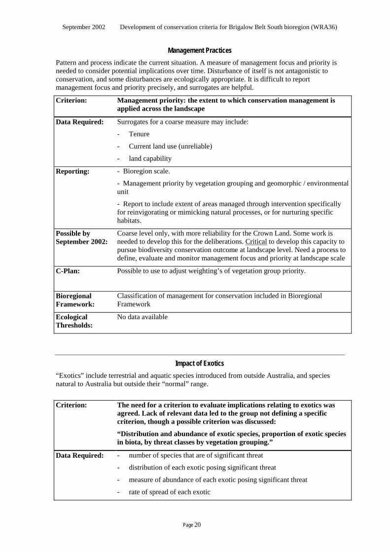
Management Practices Pattern and process indicate the current situation. A measure of management focus and priority is needed to consider potential implications over time. Disturbance of itself is not antagonistic to conservation, and some disturbances are ecologically appropriate. It is difficult to report management focus and priority precisely, and surrogates are helpful.
Criterion: Management priority: the extent to which conservation management is applied across the landscape
Data Required: Surrogates for a coarse measure may include:
- Tenure
- Current land use (unreliable)
- land capability
Reporting: - Bioregion scale.
- Management priority by vegetation grouping and geomorphic / environmental unit
- Report to include extent of areas managed through intervention specifically for reinvigorating or mimicking natural processes, or for nurturing specific habitats.
Possible by September 2002:
Coarse level only, with more reliability for the Crown Land. Some work is needed to develop this for the deliberations. Critical to develop this capacity to pursue biodiversity conservation outcome at landscape level. Need a process to define, evaluate and monitor management focus and priority at landscape scale
C-Plan: Possible to use to adjust weighting’s of vegetation group priority.
Bioregional Framework:
Classification of management for conservation included in Bioregional Framework
Ecological Thresholds:
No data available
Impact of Exotics “Exotics” include terrestrial and aquatic species introduced from outside Australia, and species natural to Australia but outside their “normal” range.
Criterion: The need for a criterion to evaluate implications relating to exotics was
agreed. Lack of relevant data led to the group not defining a specific criterion, though a possible criterion was discussed:
“Distribution and abundance of exotic species, proportion of exotic species in biota, by threat classes by vegetation grouping.”
Data Required: - number of species that are of significant threat
- distribution of each exotic posing significant threat
- measure of abundance of each exotic posing significant threat
- rate of spread of each exotic
September 2002 Development of conservation criteria for Brigalow Belt South bioregion (WRA36)
Page 21
- rate of new naturalisations
- geomorphic / environmental units
- vegetation groupings
Reporting: Relative cover and abundance of exotic plants by vegetation grouping and geomorph / environmental unit by Sept. 2002
Possible by September 2002:
It may be possible to evaluate relative cover and abundance of exotic plants by vegetation grouping and geomorph / environmental unit
C-Plan: A potential use might be to modify a vulnerability index.
Bioregional Framework:
May be included in threats layer.
Ecological Thresholds:
None known.
Value: Certainty of Conservation Management Discussion
There was considerable discussion about the relevance of the JANIS criteria for this process. The Group understood that following the forthcoming deliberations the government will make decisions on the future tenure and management of public land in the bioregion in September 2002.
Table 2 in the Discussion paper (Minimum requirements for classes of strength of certainty that conservation management will persist) was discussed particularly in relation to those categories of certainty class which met the CAR reserves definitions. It was generally accepted that Dedicated reserves have a higher level of certainty than any other category because of the requirement for Parliamentary action to change the boundary. It was also accepted that the terms Informal Reserve, Reserve by Prescription and Other Reserve are appropriate for areas under Crown tenure, but the point was made that areas of private land which meet the CAR reserve classification should not be referred to as reserves. The Group thought that “Private Land managed for Conservation” or a similar term was needed to distinguish it from the Crown land reserve classifications, to reflect the fact that formal and informal conservation management does occur on private land. However, such a classification should still be included when assessing the area that qualifies under the CAR reserve system. The Group was supportive of the need to acknowledge off-reserve conservation efforts in the table.
The concept of certainty of conservation management was seen as a component of Landscape Function and Sustainability and the Group suggested that it would logically fit following the Management Priority criteria under that value. The Group discussed the criteria put forward in the discussion paper, the JANIS criteria, and the modifications to the JANIS criteria suggested in a paper by Nix and Mackey (1999).
There was a range of responses put forward by the experts, including:
• there is no choice but to use JANIS for public land reserve decisions because of the short time left until deliberation
• JANIS is not relevant to the landscape as a whole
• JANIS is not appropriate for use in this landscape
• JANIS creates an ecological apartheid of reserve / non reserve
• Need to know how reserves are placed in the landscape to be able to measure the benefit to biodiversity
September 2002 Development of conservation criteria for Brigalow Belt South bioregion (WRA36)
Page 22
• Support for JANIS to assist in public land reserve decisions but aware that bioregional issues are different to those addressed by JANIS and recognise the need for a landscape approach for conservation issues across the bioregion; believe Bioregional Framework will address this
However, the group acknowledged that it was not in a position to devise a competent alternative set of criteria for the deliberations. The group recognised that JANIS seemed the only option for guiding selection of areas for a reserve system during the deliberations in September 2002.The modifications suggested by Nix and Mackey were not recommended as the paper has not been released yet and consideration of the changes could not be considered at the workshop.
It was also agreed that the JANIS reserve design principles were appropriate as guidelines for the deliberations and need not be incorporated into C-plan for the public land decisions being made in September 2002.
The Group was also asked whether it saw the setting of targets as appropriate off reserve. This was seen as desirable to be done in conjunction with Catchment Management Boards and Native Vegetation Committees. Such targets would need to recognise the variation across the bioregion and done on an ecological basis.
The issue of reporting on each value was raised and suggestions were sought by the project manager for a methodology for providing a “score” for each value based on the range of criteria under it. The project manager agreed to circulate a proposal to the Group out of session for advice. It was generally agreed though, that the reporting should be aimed at relative health of the landscape and whether it is getting better or worse.
A discussion on the relevance of wilderness and old growth as criteria for the BBS took place towards the end of the workshop (NPWS and one expert were not present during this session). Those present commented that old growth was not relevant to this bioregion but that “late mature growth stage” (definition required) may be a substitute. The Group believed that the community places a value on patches of large old trees and that ecologists also recognise their value. It was agreed that there was an expectation that criteria would be included which addressed this issue but that there was little data available and it may not be possible to deliver on this criteria by September 2002.
Those present also commented that wilderness is more a cultural concept, than a biodiversity issue and in some circumstances (e.g. through inability to manage it) may limit achievement of biodiversity conservation outcomes.
Summary of recommendations:
• “Certainty of Conservation Management” be included as criteria under the Landscape Function and Sustainability value.
• Time constraints suggest that the JANIS criteria should be used to assist public land reserve selection decisions in September 2002, despite the groups concerns about its applicability in the bioregion and the limited relevance to biodiversity conservation at a bioregional scale.
• Guidelines should be developed and applied in conjunction with Catchment Management Boards and Native Vegetation Committees to establish goals at landscape level (post September 2002).
• An alternative approach to JANIS be explored for future conservation planning and land use considerations in landscapes that are highly disturbed and largely private tenures.
The criteria to be used to report on the “Certainty of Conservation Management” (under the Landscape Function and Sustainability” value are thus:
September 2002 Development of conservation criteria for Brigalow Belt South bioregion (WRA36)
Page 23
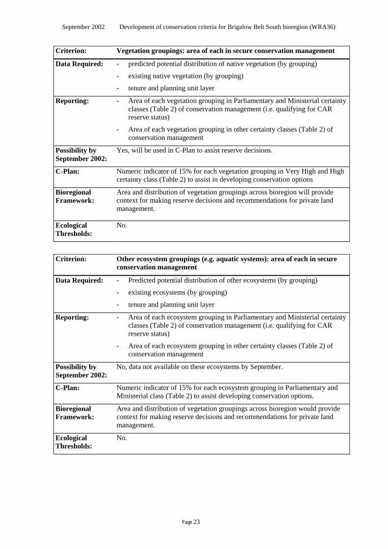
Criterion: Vegetation groupings: area of each in secure conservation management
Data Required: - predicted potential distribution of native vegetation (by grouping)
- existing native vegetation (by grouping)
- tenure and planning unit layer
Reporting: - Area of each vegetation grouping in Parliamentary and Ministerial certainty classes (Table 2) of conservation management (i.e. qualifying for CAR reserve status)
- Area of each vegetation grouping in other certainty classes (Table 2) of conservation management
Possibility by September 2002:
Yes, will be used in C-Plan to assist reserve decisions.
C-Plan: Numeric indicator of 15% for each vegetation grouping in Very High and High certainty class (Table 2) to assist in developing conservation options
Bioregional Framework:
Area and distribution of vegetation groupings across bioregion will provide context for making reserve decisions and recommendations for private land management.
Ecological Thresholds:
No.
Criterion: Other ecosystem groupings (e.g. aquatic systems): area of each in secure conservation management
Data Required: - Predicted potential distribution of other ecosystems (by grouping)
- existing ecosystems (by grouping)
- tenure and planning unit layer
Reporting: - Area of each ecosystem grouping in Parliamentary and Ministerial certainty classes (Table 2) of conservation management (i.e. qualifying for CAR reserve status)
- Area of each ecosystem grouping in other certainty classes (Table 2) of conservation management
Possibility by September 2002:
No, data not available on these ecosystems by September.
C-Plan: Numeric indicator of 15% for each ecosystem grouping in Parliamentary and Ministerial class (Table 2) to assist developing conservation options.
Bioregional Framework:
Area and distribution of vegetation groupings across bioregion would provide context for making reserve decisions and recommendations for private land management.
Ecological Thresholds:
No.
September 2002 Development of conservation criteria for Brigalow Belt South bioregion (WRA36)
Page 24
Criterion: Wilderness: area of wilderness with NWI 12+ in secure conservation management
Data Required: - NWI 12+
- tenure and planning unit layer
Reporting: - Area of qualifying wilderness in Parliamentary and Ministerial certainty classes (Table 2) (i.e. qualifying for CAR reserve status)
Possibility by September 2002:
Yes, will be used in C-Plan to assist reserve decisions.
C-Plan: Numeric indicator of 100% (minimum area of 8000ha) for wilderness with NWI 12+ in Parliamentary and Ministerial certainty class (Table 2) to assist in developing conservation options.
Bioregional Framework:
Area and distribution of wilderness across bioregion will provide context for making reserve decisions and recommendations for private land management.
Ecological Thresholds:
No.
Criterion: Late mature growth stage: area in secure conservation management
Data Required: - predicted potential distribution of each vegetation grouping in late mature growth stage
- existing distribution of each vegetation grouping in late mature growth stage
- tenure and planning unit layer Reporting: - Area of late mature growth stage in each Parliamentary and Ministerial
certainty classes (Table 2) of conservation management (i.e. qualifying for CAR reserve status)
- Area of late mature growth stage in other certainty classes (Table 2) of conservation management
Possibility by September 2002:
No. Insufficient data available.
C-Plan: Numeric indicator for each vegetation grouping in late mature growth stage in Parliamentary and Ministerial certainty class (Table 2) to assist in developing conservation options.
Bioregional Framework:
Distribution of vegetation groupings in late mature growth stage across bioregion will provide context for making reserve decisions and recommendation on private land management.
Ecological Thresholds:
No.
September 2002 Development of conservation criteria for Brigalow Belt South bioregion (WRA36)
Page 25
Criterion: Rare and endangered vegetation groupings (i.e. JANIS definition): area in secure conservation management
Data Required: - predicted potential distribution of each rare and endangered vegetation grouping
- existing distribution of each rare and endangered vegetation grouping - tenure and planning unit layer
Reporting: - Area of each rare and endangered vegetation in each Parliamentary and Ministerial certainty classes (Table 2) of conservation management (i.e. qualifying for CAR reserve status)
- Area of each rare and endangered vegetation in other certainty classes (Table 2).
Possibility by September 2002:
Yes, will be used in C-Plan to assist reserve decisions.
C-Plan: Numeric indicator of 100% for each rare and endangered vegetation grouping in Parliamentary and Ministerial certainty class (Table 2) to assist in developing conservation options.
Bioregional Framework:
Distribution of rare and endangered vegetation across bioregion will provide context for making reserve decisions and recommendations on private land management.
Ecological Thresholds:
No.
Criterion: Vulnerable vegetation groupings (i.e. JANIS definition): area in secure conservation management
Data Required: - predicted potential distribution of each vulnerable vegetation group
- existing distribution of each vulnerable vegetation grouping
- tenure and planning unit layer
Reporting: - Area of each vulnerable vegetation grouping in each Parliamentary and Ministerial certainty class (Table 2) of conservation management (i.e. qualifying for CAR reserve status)
- Area of each vulnerable vegetation grouping in other certainty classes (Table 2).
Possibility by September 2002:
Yes, will be used in C-Plan to assist reserve decisions.
C-Plan: Numeric indicator of 60% of the existing extent for each vulnerable vegetation grouping in Parliamentary and Ministerial certainty class (Table 2) to assist in developing conservation options.
Bioregional Framework:
Distribution of each vulnerable vegetation grouping across bioregion will provide context for making reserve decisions and recommendation on private land management.
Ecological Thresholds:
No.
September 2002 Development of conservation criteria for Brigalow Belt South bioregion (WRA36)
Page 26
Criterion: Habitat of particular quality (being natural refugia or critical habitat features) for “at risk” species with special needs: area of each in secure conservation management (rare/endangered species, groups of organisms with complex habitat requirements, migratory or mobile species, species with requirements not well correlated with vegetation groupings
Data Required: - Species with special needs - Defined habitats of species with special needs - predicted potential distribution of each habitat - existing distribution of habitat - tenure and planning unit layer
Reporting: - Area of habitat in each Parliamentary and Ministerial certainty classes (Table 2) of conservation management (i.e. qualifying for CAR reserve status)
- Area of habitat in other certainty classes (Table 2)
Possibility by September 2002:
Possibly for a limited range of entities. May be used in C-Plan to assist reserve decisions. Dependent on Response to Disturbance and fauna assemblage data.
C-Plan: Maximise for each habitat in Parliamentary and Ministerial certainty class (Table 2) to assist in developing conservation options.
Bioregional Framework:
Distribution of habitats across bioregion will provide context for making reserve decisions and recommendation on private land management.
Ecological Thresholds:
No.
Value: Vulnerability
The group discussed the issue of vulnerability of ecosystems to further degradation, and whether it should be treated as a value in its own right. Vulnerability of ecosystems to a number of threats, both now and in the future, was seen to be a key issue needing conservation criteria. Some ecosystems are more at risk where a number of threats interact and some are more at risk than others. A ranking of disturbance from those threats was suggested. From this information separate spatial layers could be developed which shows the threats for each ecosystem. This could also be further broken down to geomorphological / environmental units. The point was made though that this needs to be restricted to those threats that we can get some kind of measure on (including the effect between threats – multiplying / additive / exponential), otherwise they could be ranked as a simple high, medium or low. It was agreed that those threats that could be ameliorated through reservation should be separated from those which could not (e.g. rising groundwater) for possibility of incorporating in C-Plan. NPWS also pointed out that local threats would need to be separated from bioregional threats in order to determine whether C-Plan or the Bioregional Framework would be appropriate.
The Group agreed on the following criteria:
September 2002 Development of conservation criteria for Brigalow Belt South bioregion (WRA36)
Page 27
Criterion: Vulnerability of ecosystems to further degradation
Data Required: - key threats (rising groundwater, salinity, weeds, ferals, clearing, timber removal, flooding, cropping cycles
Reporting: Local / bioregional threats compounded and reported by ecosystem per geomorphological / environmental unit
C-Plan: Vulnerability index (?)
Bioregional Framework:
Bioregional threats
Ecological Thresholds:
Not known
Possibility by September 2002:
Some threats (clearing, proximity to development) included in Bioregional Framework but no criteria able to be reported on directly for deliberations in September 2002.
Recommendations Emerging from Workshop The following agreements and recommendations emerged from the Expert Workshop:
• Agreement on the range of primary conservation values in the Discussion paper as those relevant to the bioregion.
• The criteria included in this report are suitable for the bioregion.
• Given the short time to develop any alternative, the JANIS criteria were accepted for use to assist deliberations on public land reserve decisions.
• Following the September deliberations, there be a movement towards development of more appropriate whole-of-landscape conservation criteria.
• Further development to finalise the criteria should be pursued in consultation with experts, Catchment Management Boards and Native Vegetation Management Committees.
• Implementation and monitoring of the criteria be incorporated in the suite of recommendations following the Western Regional Assessment deliberations.
• Rate of change needs to be embodied in the monitoring and reporting.
• Condition assessment is a high priority for further development whole of landscape conservation criteria.

September 2002 Development of conservation criteria for Brigalow Belt South bioregion (WRA36)
Page 28
This blank page has been inserted here so the next section
appears on the right hand side in double-sided printing.

September 2002 Development of conservation criteria for Brigalow Belt South bioregion (WRA36)
Page 29
Appendix 3.1 Reserve Design Principles adapted from JANIS (1997) • Approach for developing a reserve system − Development should seek a reserve system that is comprehensive, adequate and representative − The reserve system should be developed with best data available at the time of decision
making, and in consideration of economic and social impacts. − Flexibility in the application of reserve criteria is needed in consideration of differing regional
circumstances to ensure that the reserve system delivers optimal nature conservation outcomes as well as acceptable social and economic outcomes. Therefore the (JANIS) criteria (vis C 4 (a) to (f) in this paper) are to be considered as guidelines rather than mandatory targets.
• Comprehensive − The reserve system should sample the full range of forest communities across the landscape. − Reserved areas should be replicated across the geographic range of the forest ecosystem to
decrease the likelihood that chance events such as wildfire or disease will cause the forest ecosystem to decline.
• Adequate − The reserve system should be extensive enough to ensure viability and integrity of populations,
species and communities. − Reserves should be large enough to sustain the viability, quality and integrity of populations. − Large reserved areas are preferable to small reserved areas, though a range of reserve sizes may
be appropriate to adequately sample conservation values. • Representative − The reserve system should sample the full range of biological variation within each forest
ecosystem. − To this end, as far as possible, sample the range of environmental variation typical of its
geographic range and sample its range of successional stages. − In fragmented landscapes, remnants that contribute to sampling the full range of biodiversity
are vital parts of a forest reserve system. • Boundaries and shape − Boundaries should be set in landscape context with strong ecological integrity, eg catchments. − Boundary-area ratios should be minimised and linear reserves avoided where possible, except
for riverine systems and corridors having significant nature conservation value. • Contextual considerations − Reserves should be met from public lands in the first instance. − Each reserve should contribute to satisfying as many reserve criteria as possible. − Reserve design should aim to minimise the impact of threatening processes, particularly from
adjoining areas. − Reserves should be linked through a variety of mechanisms, wherever practicable, across the
landscape.

September 2002 Development of conservation criteria for Brigalow Belt South bioregion (WRA36)
Page 30
This blank page has been inserted here so the next section
appears on the right hand side in double-sided printing.

September 2002 Development of conservation criteria for Brigalow Belt South bioregion (WRA36)
Page 31
Appendix 3.2 Summary of conservation criteria
This blank page marks where the A3 table should be inserted.
The table is found in file Project Report A3 appendices.doc

September 2002 Development of conservation criteria for Brigalow Belt South bioregion (WRA36)
Page 32
This blank page has been inserted here so the next section
appears on the right hand side in double-sided printing.

September 2002 Development of conservation criteria for Brigalow Belt South bioregion (WRA36)
Page 33
Appendix 3.3 A broad taxonomic and functional classification hierarchy of living things
This blank page marks where the A3 table should be inserted.
The table is found in file Project Report A3 appendices.doc

September 2002 Development of conservation criteria for Brigalow Belt South bioregion (WRA36)
Page 34
This blank page has been inserted here so the next section
appears on the right hand side in double-sided printing.
September 2002 Development of conservation criteria for Brigalow Belt South bioregion (WRA36)
Page 35
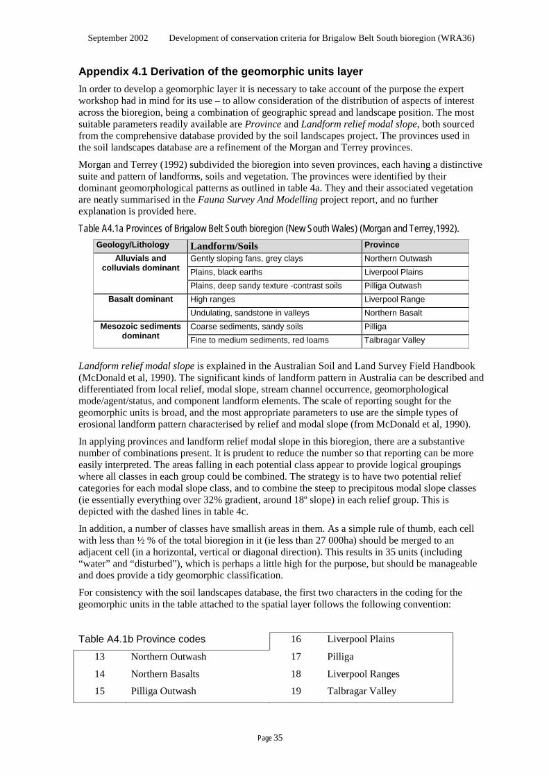
Appendix 4.1 Derivation of the geomorphic units layer In order to develop a geomorphic layer it is necessary to take account of the purpose the expert workshop had in mind for its use – to allow consideration of the distribution of aspects of interest across the bioregion, being a combination of geographic spread and landscape position. The most suitable parameters readily available are Province and Landform relief modal slope, both sourced from the comprehensive database provided by the soil landscapes project. The provinces used in the soil landscapes database are a refinement of the Morgan and Terrey provinces.
Morgan and Terrey (1992) subdivided the bioregion into seven provinces, each having a distinctive suite and pattern of landforms, soils and vegetation. The provinces were identified by their dominant geomorphological patterns as outlined in table 4a. They and their associated vegetation are neatly summarised in the Fauna Survey And Modelling project report, and no further explanation is provided here.
Table A4.1a Provinces of Brigalow Belt South bioregion (New South Wales) (Morgan and Terrey,1992). Geology/Lithology Landform/Soils Province
Gently sloping fans, grey clays Northern Outwash Plains, black earths Liverpool Plains
Alluvials and colluvials dominant
Plains, deep sandy texture -contrast soils Pilliga Outwash High ranges Liverpool Range Basalt dominant Undulating, sandstone in valleys Northern Basalt Coarse sediments, sandy soils Pilliga Mesozoic sediments
dominant Fine to medium sediments, red loams Talbragar Valley
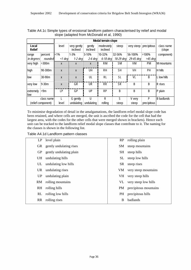
Landform relief modal slope is explained in the Australian Soil and Land Survey Field Handbook (McDonald et al, 1990). The significant kinds of landform pattern in Australia can be described and differentiated from local relief, modal slope, stream channel occurrence, geomorphological mode/agent/status, and component landform elements. The scale of reporting sought for the geomorphic units is broad, and the most appropriate parameters to use are the simple types of erosional landform pattern characterised by relief and modal slope (from McDonald et al, 1990).
In applying provinces and landform relief modal slope in this bioregion, there are a substantive number of combinations present. It is prudent to reduce the number so that reporting can be more easily interpreted. The areas falling in each potential class appear to provide logical groupings where all classes in each group could be combined. The strategy is to have two potential relief categories for each modal slope class, and to combine the steep to precipitous modal slope classes (ie essentially everything over 32% gradient, around 18º slope) in each relief group. This is depicted with the dashed lines in table 4c.
In addition, a number of classes have smallish areas in them. As a simple rule of thumb, each cell with less than ½ % of the total bioregion in it (ie less than 27 000ha) should be merged to an adjacent cell (in a horizontal, vertical or diagonal direction). This results in 35 units (including “water” and “disturbed”), which is perhaps a little high for the purpose, but should be manageable and does provide a tidy geomorphic classification.
For consistency with the soil landscapes database, the first two characters in the coding for the geomorphic units in the table attached to the spatial layer follows the following convention:
Table A4.1b Province codes 16 Liverpool Plains
13 Northern Outwash 17 Pilliga
14 Northern Basalts 18 Liverpool Ranges
15 Pilliga Outwash 19 Talbragar Valley
September 2002 Development of conservation criteria for Brigalow Belt South bioregion (WRA36)
Page 36
Table A4.1c Simple types of erosional landform pattern characterised by relief and modal slope (adapted from McDonald et al, 1990)
Modal terrain slope Local Relief
level very gently inclined
gently inclined
moderately inclined
steep very steep precipitous class name (slope
range percent <1% 1-3% 3-10% 10-32% 32-56% 56-100% >100% component) in degrees rounded <1 deg 1-2 deg 2-6 deg 6-18 deg 18-29 deg 29-45 deg >45 deg very high >300m x x x RM SM VM PM M mountains
high 90-300m x x UH RH SH VH PH H hills
low 30-90m x x UL RL SL VL B L low hills
very low 9-30m x GR UR RR SR B B R rises
extremely low
<9m LP GP UP RP B B B P plain
class name L G gently U R S V very P B badlands (relief component) level undulating undulating rolling steep steep precipitous
To minimise degradation of detail in the amalgamations, the landform relief modal slope code has been retained, and where cells are merged, the unit is ascribed the code for the cell that had the largest area, with the codes for the other cells that were merged shown in brackets). Hence each unit can be tracked to the landform relief modal slope classes that contribute to it. The naming for the classes is shown in the following list.
Table A4.1d Landform pattern classes
LP level plain RP rolling plain
GR gently undulating rises SM steep mountains
GP gently undulating plain SH steep hills
UH undulating hills SL steep low hills
UL undulating low hills SR steep rises
UR undulating rises VM very steep mountains
UP undulating plain VH very steep hills
RM rolling mountains VL very steep low hills
RH rolling hills PM precipitous mountains
RL rolling low hills PH precipitous hills
RR rolling rises B badlands

September 2002 Development of conservation criteria for Brigalow Belt South bioregion (WRA36)
Page 37
Appendix 4.2 Derivation of the tenure grouping layer For reporting in the immediate deliberations, the experts sought sub-totals in the criteria reporting for “Crown” estate and all other estate. The Crown tenure data supplied for the immediate deliberations was largely un-validated, and only validated lands were accepted for negotiation at this time. Lands recorded as tenure that would be negotiable but that are un-validated might be for contemplated for further consideration in the deliberations but would not be subject to negotiation at this time. There is then a need in the immediate deliberations to highlight three tenure groupings:
Negotiable all Crown-managed land that has been validated
Potentially negotiable all Crown-managed land that is un-validated
Non-negotiable all other land
These have been derived as follows, using the Planning Unit layer and the CLID data in the Tenure layer. Table A4.2b lists all the CLID codes, tenure descriptions and negotiability class for all units in the CLID tenure layer.
Negotiable The lands identified with tenure codes hereunder in the Planning Unit Layer
SFN State forest, native ............................. 595 571ha
SFJV State forest, joint venture....................... 4 301ha
SFI Crown land of interest to SFNSW....... 12 146ha
S7 State forest section 7.................................. 0.2ha
TR Timber Reserve ..................................... 1 528ha
NP NPWS estate...................................... 170 953ha
NPP NPWS acquired but not gazetted........... 6 291ha
NPI Crown land of interest to NPWS ......... 14 897ha 765 687ha
Potentially negotiable
The intersection of the land identified with “potentially negotiable” CLID codes (as shown in table A4.2a) in the Tenure layer with lands identified with tenure codes DLWC or OTH (in the Planning Unit layer).
Table A4.2a CLID codes for potentially negotiable lands
Tenure group Code Tenure code descriptions Class for negotiability
Unconstrained (assumed) 120 Other crown land – status Crown Potentially negotiable
Public reserve 410 Public recreation reserve Potentially negotiable
Special reserve 420 Reserved from sale for future public requirements
Potentially negotiable
Public reserve 440 Commons Potentially negotiable
Public reserve 450 Reserve from lease / licence Potentially negotiable
Public reserve 480 Other reservation Potentially negotiable
Public reserve 490 Non-notified reserve Potentially negotiable
Lease/licence 620 Licence / permissive occupancy Potentially negotiable
Lease/licence TERM Term lease Potentially negotiable
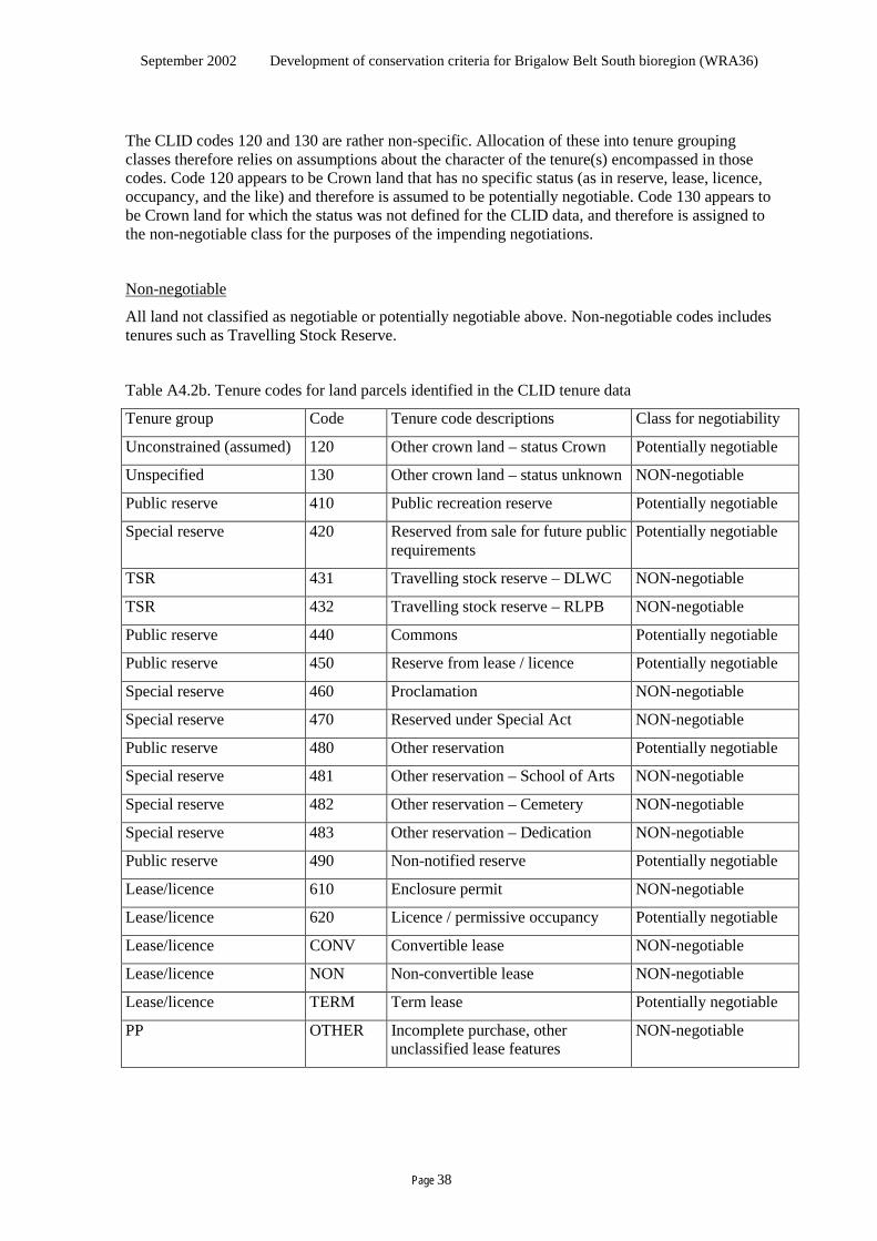
September 2002 Development of conservation criteria for Brigalow Belt South bioregion (WRA36)
Page 38
The CLID codes 120 and 130 are rather non-specific. Allocation of these into tenure grouping classes therefore relies on assumptions about the character of the tenure(s) encompassed in those codes. Code 120 appears to be Crown land that has no specific status (as in reserve, lease, licence, occupancy, and the like) and therefore is assumed to be potentially negotiable. Code 130 appears to be Crown land for which the status was not defined for the CLID data, and therefore is assigned to the non-negotiable class for the purposes of the impending negotiations.
Non-negotiable
All land not classified as negotiable or potentially negotiable above. Non-negotiable codes includes tenures such as Travelling Stock Reserve.
Table A4.2b. Tenure codes for land parcels identified in the CLID tenure data
Tenure group Code Tenure code descriptions Class for negotiability
Unconstrained (assumed) 120 Other crown land – status Crown Potentially negotiable
Unspecified 130 Other crown land – status unknown NON-negotiable
Public reserve 410 Public recreation reserve Potentially negotiable
Special reserve 420 Reserved from sale for future public requirements
Potentially negotiable
TSR 431 Travelling stock reserve – DLWC NON-negotiable
TSR 432 Travelling stock reserve – RLPB NON-negotiable
Public reserve 440 Commons Potentially negotiable
Public reserve 450 Reserve from lease / licence Potentially negotiable
Special reserve 460 Proclamation NON-negotiable
Special reserve 470 Reserved under Special Act NON-negotiable
Public reserve 480 Other reservation Potentially negotiable
Special reserve 481 Other reservation – School of Arts NON-negotiable
Special reserve 482 Other reservation – Cemetery NON-negotiable
Special reserve 483 Other reservation – Dedication NON-negotiable
Public reserve 490 Non-notified reserve Potentially negotiable
Lease/licence 610 Enclosure permit NON-negotiable
Lease/licence 620 Licence / permissive occupancy Potentially negotiable
Lease/licence CONV Convertible lease NON-negotiable
Lease/licence NON Non-convertible lease NON-negotiable
Lease/licence TERM Term lease Potentially negotiable
PP OTHER Incomplete purchase, other unclassified lease features
NON-negotiable
September 2002 Development of conservation criteria for Brigalow Belt South bioregion (WRA36)
Page 39
Appendix 4.3 Derivation of the management priority layer To derive a very course management priority data set for the bioregion, the Crown-managed lands were treated separately to the remainder of the lands due to the more refined detail possible regarding management focus. The Crown-managed lands identified are taken as the lands identified with the following codes in the Planning Unit layer:
SFN State forest, native ............................. 595 571ha
SFJV State forest, joint venture....................... 4 301ha
S7 State forest section 7.................................. 0.2ha
TR Timber Reserve ..................................... 1 528ha
NP NPWS estate...................................... 170 953ha
NPP NPWS acquired but not gazetted........... 6 291ha
The land outside the Crown-managed land was dealt with on the basis of tenure (CLID codes), the Landcover data and the Land capability classification. The CLID codes were grouped on the basis of likely similarities in management focus at a gross level (table A4.3a), and areas covered in the Crown-managed land were excised.
Table A4.3a CLID codes in management focus groups Focus group CLID codes PP OTHER Lease/licence/PO 610, 620, CONV, NON, TERM TSR 431, 432 Special reserve 481, 482, 483, 470, 460, 420 Public reserve 490, 480, 450, 440, 410 VCL and the like 120, 130
All areas not included in the above categories were added to the PP focus group.
The Land capability classification excluded National Parks, State Parks, State Forest and the like, as they were at the time of the classification in the late 1980s. Thus there may be some current NP, SF, etc that has a Landcover classification, and some areas that have been revoked that have no Landcover classification. The Landcover classification is indicative only, being not validated, and neither absolute nor definitive.
Areas were then identified by overlapping Land capability, focus group and Landcover class, and a nominal management priority classification was applied to each as depicted in the following tables. Areas with Land capability class 8 or M or U were excised.
September 2002 Development of conservation criteria for Brigalow Belt South bioregion (WRA36)
Page 40
SFN FMZ 1 Conservation A
FMZ 2 50% Conservation A, 50% Conservation B
FMZ 3 Conservation B
FMZ 4 Joint conservation and production
FMZ 5 Production A
FMZ 6 Production B
FMZ 7 Production B
FMZ 8 Joint conservation and production
SFJV Joint conservation and production
S7 Production A
TR Production A
NP Conservation A
NPP Conservation B
This is obviously extremely coarse and broad.
• The assumptions about land other than the identified Crown-managed land is very gross, and does not encompass the potential for the management focus of some areas to be quite different from the nominated class. Spatial data was not readily available for a range of circumstances where management priority might be more precisely estimated, such as wildlife refuge, voluntary conservation agreement, RAMSAR wetland, fencing initiative program, property plans and agreements (under various regulatory instruments such as the Native Vegetation Conservation Act).
• The assumptions about the Crown-managed land are more refined, but are limited by the level of data available. For example, spatial details for State Park, Regional Park, Aboriginal Area, Historic sites and Karst reserves was not achieved for this project.
• State Conservation areas have yet to be implemented, however they would come under I in this classification. The management focus of Travelling Stock Reserves is already varied, however, whilst an emerging shift in focus toward conservation is evident, they have been classified on the basis of their perceived general management in the bioregion.
However, the outcome should be indicative at a coarse scale, and appears adequate for contextual reporting and providing a relative indication of outcomes for the impending deliberations.
September 2002 Development of conservation criteria for Brigalow Belt South bioregion (WRA36)
Page 41
Table A4.3b Management priority classification for lands other than agency managed
Land capability classification Tenure Nominal management priority class by landcover class # Class Suitable for 2.
waterbody 3.
cropping 7. grassland /
open woodland 1.
timber 1 to 3 PP PB PB PB PA Lease/licence/PO PB PB PA PA TSR PB PB PA PA Special reserve PB PA PA PA Public reserve PB PA I I
Regular cultivation
VCL and the like I I I I 4 PP PB PB PB PA Lease/licence/PO PB PA PA PA TSR PB PA PA PA Special reserve PA PA PA PA Public reserve PA PA I I
Grazing, minimal cultivation for permanent pasture
VCL and the like I I I I 5 PP PB PB PA PA Lease/licence/PO PB PA PA PA TSR PB PA PA PA Special reserve PA PA PA I Public reserve PA I I I
Grazing, minimal cultivation for permanent pasture
VCL and the like I I I I 6 PP PA PA PA PA Lease/licence/PO PA PA PA PA TSR PA PA PA PA Special reserve PA PA I I Public reserve I I I I
Grazing only
VCL and the like I I I I 7 PP I I I I Lease/licence/PO I I I I TSR I I I I Special reserve I I I I Public reserve I I I CB
Timber protection
VCL and the like I I CB CB 8, M, U
Exclude from reporting
PP – effectively private, TSR – travelling stock reserve, PO – permissive occupancy, VCL – vacant Crown land

September 2002 Development of conservation criteria for Brigalow Belt South bioregion (WRA36)
Page 42
This blank page has been inserted here so the next section
appears on the right hand side in double-sided printing.
September 2002 Development of conservation criteria for Brigalow Belt South bioregion (WRA36)
Page 43
Appendix 4.4 Derivation of the management certainty layer
Only area categories with spatial data available or proposed to be available for the impending deliberations have been classified here. Only those meeting the minimum requirement for classification have been recorded, being those areas under “conservation management” (ie established in and managed in accord with a formal management plan for explicit conservation outcomes, as discrete mapped areas or as prescription areas). The minimum requirements in table 4c attempt to structure in a consistent way the requirements embodied in the JANIS (1997) and IUCN (1994) guidelines.
• The requirements in these references focus on the security of boundaries and having appropriate management. Accountability for boundaries is addressed in a general way in those references, and table 4c attempts to specify those requirements in concrete terms.
• However, secure boundaries are of little use unless the management regime is also secure and appropriate. The appropriateness of management regimes and accountability for approval of them are not specified in the foregoing guidelines. Table 4c extends the JANIS (1997) requirements by nominating accountability for the management regime. The approval “level” is “lower” than that specified for boundaries in recognition of the need to appreciate the detail of the management instrument, but having a clear line of accountability to the level specified for boundaries. This is a result of the likely need to revise management regimes from time to time as active adaptive management is employed (Walker, 1998), whereas the boundaries are likely to be far more stable.
• Table 4c goes beyond the reserve system requirements in order to recognise all forms of conservation management. This is valuable for the bioregion because improved conservation outcomes will rely on much more than the reserve system that Crown-managed land can deliver. As a measure of progress, all forms need to be reported, to provide a more accurate indication of the broad conservation effort in the bioregion, and to recognise the contribution towards conservation that land managers make without qualifying for “reserve” status.
Table A4.4b presents the data used to classify the relevant areas. For dedicated estate of National Parks and Wildlife Service the data was adopted from information supplied that did not cover all elements, involving assumptions that are yet to be validated by the Service. For dedicated estate of State Forests of New South Wales, the data was supplied by that agency. The classification in table 4.4a is based on the minimum requirements as specified in table 4c. Table A4.4a Classification of certainty that conservation management will apply and persist
Tenure / Management Category
Planning Unit layer code Certainty category Certainty class
National Park Nature Reserve Dedicated Wilderness
NP Dedicated reserve Parliamentary
State/National Forest SFN FMZ 1 Dedicated reserve Parliamentary FMZ 2 Informal reserve Ministerial (no term) FMZ 3 Informal reserve Ministerial (no term)
FMZ 4 (prescription) Prescription Ministerial (no term) FMZ 4 (other) Con area (agency) Term / sub-Ministerial
Note that the approval of FMZ4 boundaries, whilst not overtly direct, is indirectly undertaken by the approval of the other FMZ zones that in effect dictate the FMZ 4 boundaries that are not the State or National forest boundaries.
September 2002 Development of conservation criteria for Brigalow Belt South bioregion (WRA36)
Page 44
• The assessment of certainty that conservation management will apply and persist, involves value judgements, such as:
- the degree to which the management plan or code of practice explicitly defines competent conservation objectives
- the achievability of those objectives (are they realistic)
- the capacity and commitment of the land manager to achieve them.
These lie with the person accountable for management plan approval in the requirements proposed in table 4c.
• Spatial data was not available for initiatives off State Forests of NSW and NSW National Parks and Wildlife Service estate, such as wildlife refuge, voluntary conservation agreement, RAMSAR wetland, fencing initiative program, property plans and agreements (under various regulatory instruments such as the Native Vegetation Conservation Act). Hence the contribution of these cannot be evaluated here.
• The classification of the Crown-managed land is more refined, but is limited by the level of data available. For example, spatial details for State Park, Regional Park, Aboriginal Area, Historic sites and Karst reserves was not achieved for this project. Some of these are embodied within like-certainty tenures such as National Park.
• As the impending deliberations will focus on Crown-managed land, this will not preclude implementation for those deliberations. However the reporting may understate the area in the various certainty classes, particularly the contribution of State Parks, Regional Parks, voluntary conservation agreements, and the like.
The outcome should be adequate for negotiating outcomes over Crown-managed land for the impending deliberations, and for contextual reporting and providing a relative indication of outcomes at a regional scale, with a few provisos: • State Conservation areas have yet to be implemented, and cannot be classified until more is
known about their parameters. If any are proposed, the mechanism of accounting for their contribution to the certainty reporting will need to be addressed.
• Areas qualifying management by prescription have not been spatially identified. This will be an issue regarding State Forest FMZ 4 (prescription) in particular. The mechanism of accounting for their contribution to the certainty reporting will need to be addressed.
Precedence of other instruments: Some of the instruments that provide for the certainty of management may be subject to legislation that takes precedence. For example, the Rural Fires Act and Noxious Weeds Act. There exists the possibility of perturbation of management regimes that are, in themselves, secured under legislative arrangements. This may appear to erode the certainty that conservation management will persist. There are, however, a number of arrangements that serve to limit outcomes that might conflict with the conservation management and that lift the decision of a response to the level appropriate to the level the conservation management regime was approved at. For example:
• Rural Fires Act: Any management requirements appear to flow from the established mechanisms that are accountable to the community and government, include representation for agencies, and are required to take environmental aspects into consideration. Perceived conflicts could be brought to the relevant Committee, and referred to a higher level if necessary.
• Mines Act: A mining company must seek the consent of the landowner for proposed works on the property. Where the proposed activity conflicts with the landowner’s management objectives, and the company cannot work around the aspect generating the conflict, there is a resolution mechanism that can end up at a Wardens Court. In the case of an instrument where the management objectives/regime are approved by a Minister of the Crown and the proposed activities are in conflict with the objectives/ regime, then effectively it would require Ministerial agreement for a change before the activity could proceed.
September 2002 Development of conservation criteria for Brigalow Belt South bioregion (WRA36)
Page 45
Table A4.4b Base data used to classify certainty of conservation management
Management intent Accountability (set-up of and changes to:) Control Term Certainty category
Tenure / Management Category Identified area* OR
Prescription based Establi-shed in
Management Plan Boundaries
Comment and advice
Plan approved by
Comment and advice
Boundaries approved by
Area
set a
side /
man
aged
sp
ecific
ally f
or ex
plicit
co
nser
vatio
n outc
omes
Area
man
aged
for e
xplic
it co
nser
vatio
n outc
omes
(incl
ecos
yste
m h
ealth
???)
Mana
ged s
pecif
ically
for
expli
cit co
nser
vatio
n out-
come
s by p
resc
riptio
n ##
Mana
ged i
n acc
ord w
ith a:
MP
form
al ma
n’men
t plan
** C
P fo
rmal
Cod
e of
Pra
ctic
e**
Oppo
rtunit
y for
publi
c co
mmen
t prio
r to f
inalis
ing
Advis
ed pr
ior to
finali
sing b
y: G
gove
rnme
nt ag
ency
N
NGI c
ompe
tent in
lscp
con#
MC
Mini
ster o
f the C
rown
CE
CEO
of go
vt ag
ency
GM
GM
of go
vt ag
ency
SM
¹ of b
ody a
ccou
nts to
gov’t
Oppo
rtunit
y for
publi
c co
mmen
t prio
r to f
inalis
ing
Advis
ed by
gove
rnme
nt ag
ency
prior
to fin
alisin
g
PA P
arlia
menta
ry ac
tion
MC M
iniste
r of th
e Cro
wnª
CE C
EO of
govt
agen
cy or
bo
dy ac
coun
table
to go
v’t
By or
in co
-ope
ratio
n with
a go
vern
ment
agen
cy
Supp
orted
or ad
vised
by
G go
vern
ment
agen
cy
N NG
I com
peten
t in ls
cp co
n#
NL no
t limi
ted
If lim
ited,
spec
ify m
inim
um
term
in ye
ars
✔ ✔ ✔ MP / CP ✔ G / N MC/CE/GM/SM ✔ ✔ PA / MC / CE ✔ G / N NL / years Dedicated reserve
National Park Nature Reserve Dedicated Wilderness
✔ MP ✔ MC ✔ PA NL
State/National Forest Dedicated reserve
FMZ 1 ✔ MP ✔ MC ✔ PA ✔ NL
Informal reserve
FMZ 2 ✔ MP ✔ GM ✔ PA ✔ NL
Informal reserve
FMZ 3 ✔ MP ✔ GM ✔ MC ✔ NL
Prescription
FMZ 4 (prescription) ✔ MP ✔ GM ✔ GM ✔ NL
Con area (agency)
FMZ 4 (other) ✔ MP ✔ GM ✔ GM ✔ NL
# or non-government institution competent in landscape conservation. ¹ Senior manager of government agency (eg Regional Manager, Regional Director) or body accountable to government. ## Where separation of an area is not practical. EG, fragmented distribution, linear form. ª Where the land is not Crown land, the boundaries must be equivalent to binding successors in title. * The area can be accurately identified on maps, and is sufficient size and design to maintain the natural values specified to be protected. Except for formal reserves boundaries may be flexible over time to reflect ecosystem dynamics and climate change, consistent with ** and ***. ** The management prescriptions in the plan or code are competent and appropriate to maintain the natural value(s) nominated for the area. *** Generally reserved for areas of outstanding/unique natural values in a largely “undisturbed” state (equivalent to IUCN protected areas I to IV). Active intervention is permitted where required to optimise habitat conditions, conduct research, and (where consistent with these) benefit resident population.

September 2002 Development of conservation criteria for Brigalow Belt South bioregion (WRA36)
Page 46
This blank page has been inserted here so the next section
appears on the right hand side in double-sided printing.
September 2002 Development of conservation criteria for Brigalow Belt South bioregion (WRA36)
Page 47
Appendix 5.1 Reporting format for the deliberations Consolidation reporting:
Table A5.1a Consolidation reporting format
Value Criterion
Reporting aspect Details reported as in the following tables
(a) 1. Extent of native vegetation
Areal extent of native vegetation as % of the bioregion: Minimum 36.4 %, Maximum 72.6% , Mix (min with max grassy/open w’land) 47.3%
A. Extent, condition and distinctiveness of native vegetation
(a) 2. Native vegetation coverage class
% of the bioregion within each cover class Extent Max Min Mix <10% 0% 0.1% 0% 10 to <30% 0% 9.3% 2.2% 30 to <70% 19.6% 20.9% 37.4% >70% 52.2% 5.7% 7.1% total native veg 72% 36% 47%
B. Natural cultural heritage
(a) – (b)
Aboriginal natural cultural heritage
The Aboriginal community has direct responsibility for management and maintenance of the features of cultural significance within cultural landscape areas within 0% of the bioregion.
The Aboriginal community has direct influence over management of the culturally significant elements of the natural environment, and access to use these natural resources only in their community within 9.2% of the bioregion.
C1. Landscape process
C2. Landscape pattern
(a) 2. Patch sizes TIMBER cover area: 1544752ha, mean 189.8ha, standard deviation 6511.8 (distribution chart attached).
C3. Management practices
(a) Management priority Cons A Cons B JointC/P Prod A Prod B 4% 2% 15% 26% 54%
C4. Certainty that conservation management will apply and persist
(a)-(g)
Certainty of management area Non-Aboriginal cul-tural heritage sites
Parl’t/Minister Term/non-Minister Other 306022ha 458255ha 0ha 30 70 0
C5. Impact of exotic species
D. cultural historical places
(a)-(c)
Aboriginal cultural historical places
The Aboriginal community has direct responsibility for management of the Aboriginal culturally significant places within 0% of the bioregion.
The Aboriginal community has direct influence over management of places they hold as culturally significant within 9.2% of the bioregion.
98 % of the bioregion is covered by geomorphic mapping.E. the security of species
F. vulnerability of ecosystems
September 2002 Development of conservation criteria for Brigalow Belt South bioregion (WRA36)
Page 48
Chart 1
"TIMBER" patch size distribution - BBS bioregion (detailed)
0.0
100,000.0
200,000.0
300,000.0
400,000.0
500,000.0
600,000.0
0 to <5 5 to <10 10 to<20
20 to<50
50 to<100
100 to<200
200 to<500
500 to<1k
1k to<2k
2k to<5k
5k to<10k
10k to<20k
20k to<50k
50k to<100k
100kplus
patch size class (ha)
area
in "
TIM
BER
" pa
tch
size
cla
ss
0.0%
1.0%
2.0%
3.0%
4.0%
5.0%
6.0%
7.0%
8.0%
9.0%
10.0%
11.0%
12.0%2.3 7.1 14.0 31.0 69.5 141.3 311.9 702.6 1,525.8 3,111.4 6,381.5 12,096.9 38,085.6 76,768.8 556,187.3
average patch size (ha)
perc
ent o
f bio
regi
on in
"TI
MB
ER"
in s
ize
clas
s areapercent
Chart 2
"TIMBER" patch size distribution - BBS bioregion (simplified)
0.0
100,000.0
200,000.0
300,000.0
400,000.0
500,000.0
600,000.0
0 to <1k 1k to <10k 10k to <50k 50k to <100k 100k plus
patch size class (ha)
area
in "
TIM
BER
" pa
tch
size
cla
ss
0.0%
1.0%
2.0%
3.0%
4.0%
5.0%
6.0%
7.0%
8.0%
9.0%
10.0%
11.0%
12.0%32.4 2,511.7 18,594.1 76,768.8 556,187.3
average patch size (ha)
perc
ent o
f bio
regi
on in
"TI
MB
ER"
in s
ize
clas
s areapercent
September 2002 Development of conservation criteria for Brigalow Belt South bioregion (WRA36)
Page 49
Reporting for each criterion
Table A5.1b Criterion reporting format: A(a) 1 Extent of native vegetation See the spreadsheets for Projected, Extant, Extant1 and Mix, and the summary sheet for details of vegetation groups within the bioregion (ie excluding the “buffer”). The vegetation probability surfaces used to derive this reporting estimate the extent of existing vegetation (“extant”) by applying a mask to the predicted (modelled) “potential” distribution for each vegetation grouping. The masks are broad, and represent a minimum (woody mask) and maximum (woody plus grassy/open woodland). It is difficult to classify vegetation groupings as entirely woody, grassy or woodland because they are based on species rather than structure, and may exist across a range of structural circumstances. Rather than estimating the likely distribution for each group, the tables present the data for this minimum and maximum. The Joint Vegetation Mapping project that produced these layers has provided a list of vegetation groupings that had at least around 25% of the plots falling within the grassy/open woodland, and data is also provided with the woody plus grassy/open woodland mask for these and the woody mask for the remaining groups. Due to model limitations (especially biased sampling and analytical constraints on the use of soils data), the predicted extent of some vegetation groupings is likely to be substantially overpredicted, while others are substantially underpredicted. Further sampling and analysis is required to resolve these estimates. The most seriously biased groups, with approximate estimates of extent, are as follows: Overpredicted: 22 (90,000ha), 26 (40,000ha), 33 (60,000ha), 91 (80,000ha), 123 (45,000ha), 126 (30,000ha). Underpredicted: 69 (250,000ha), 191 (250,000ha). This has not been incorporated into the reporting herewith, and thus the reporting is based on the data as supplied. The comparison with bioregion area is the total predicted potential vegetation distribution, being 5,186,766ha. Consolidation report: areal extent of native vegetation as % of bioregion area.
September 2002 Development of conservation criteria for Brigalow Belt South bioregion (WRA36)
Page 50
Table A5.1c Criterion reporting format: A(a) 2 Native vegetation coverage class This data is presented on the spreadsheets Projected, Extant, Extant1 and Mix, being for the bioregion (ie excluding the buffer). Consolidation report: % of the bioregion within each cover class
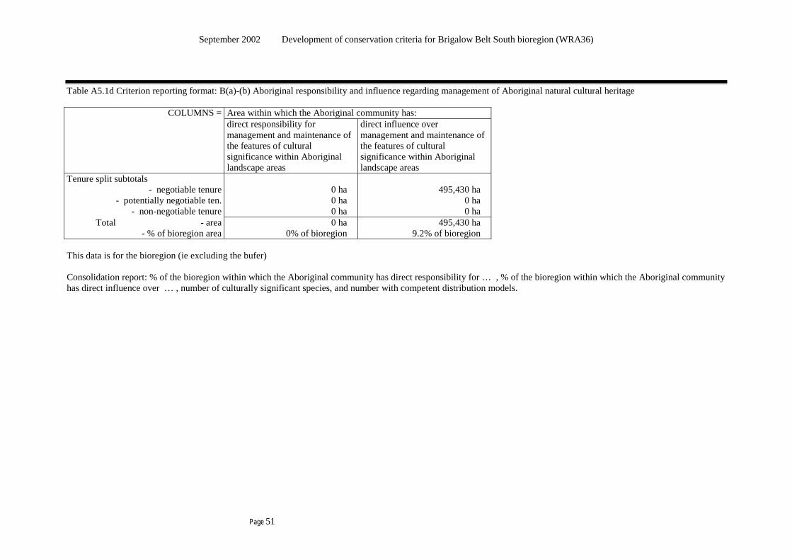
September 2002 Development of conservation criteria for Brigalow Belt South bioregion (WRA36)
Page 51
Table A5.1d Criterion reporting format: B(a)-(b) Aboriginal responsibility and influence regarding management of Aboriginal natural cultural heritage
COLUMNS = Area within which the Aboriginal community has: direct responsibility for
management and maintenance of the features of cultural significance within Aboriginal landscape areas
direct influence over management and maintenance of the features of cultural significance within Aboriginal landscape areas
Tenure split subtotals - negotiable tenure
- potentially negotiable ten. - non-negotiable tenure
0 ha 0 ha 0 ha
495,430 ha
0 ha 0 ha
Total - area - % of bioregion area
0 ha 0% of bioregion
495,430 ha 9.2% of bioregion
This data is for the bioregion (ie excluding the bufer) Consolidation report: % of the bioregion within which the Aboriginal community has direct responsibility for … , % of the bioregion within which the Aboriginal community has direct influence over … , number of culturally significant species, and number with competent distribution models.
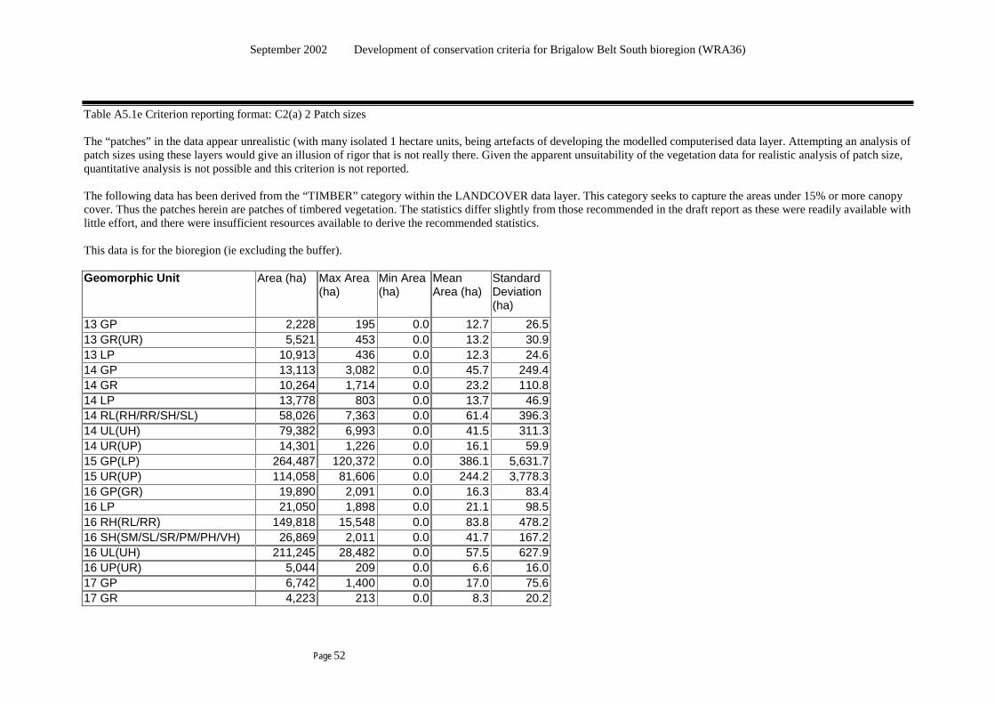
September 2002 Development of conservation criteria for Brigalow Belt South bioregion (WRA36)
Page 52
Table A5.1e Criterion reporting format: C2(a) 2 Patch sizes The “patches” in the data appear unrealistic (with many isolated 1 hectare units, being artefacts of developing the modelled computerised data layer. Attempting an analysis of patch sizes using these layers would give an illusion of rigor that is not really there. Given the apparent unsuitability of the vegetation data for realistic analysis of patch size, quantitative analysis is not possible and this criterion is not reported. The following data has been derived from the “TIMBER” category within the LANDCOVER data layer. This category seeks to capture the areas under 15% or more canopy cover. Thus the patches herein are patches of timbered vegetation. The statistics differ slightly from those recommended in the draft report as these were readily available with little effort, and there were insufficient resources available to derive the recommended statistics. This data is for the bioregion (ie excluding the buffer). Geomorphic Unit Area (ha) Max Area
(ha) Min Area (ha)
Mean Area (ha)
Standard Deviation (ha)
13 GP 2,228 195 0.0 12.7 26.5 13 GR(UR) 5,521 453 0.0 13.2 30.9 13 LP 10,913 436 0.0 12.3 24.6 14 GP 13,113 3,082 0.0 45.7 249.4 14 GR 10,264 1,714 0.0 23.2 110.8 14 LP 13,778 803 0.0 13.7 46.9 14 RL(RH/RR/SH/SL) 58,026 7,363 0.0 61.4 396.3 14 UL(UH) 79,382 6,993 0.0 41.5 311.3 14 UR(UP) 14,301 1,226 0.0 16.1 59.9 15 GP(LP) 264,487 120,372 0.0 386.1 5,631.7 15 UR(UP) 114,058 81,606 0.0 244.2 3,778.3 16 GP(GR) 19,890 2,091 0.0 16.3 83.4 16 LP 21,050 1,898 0.0 21.1 98.5 16 RH(RL/RR) 149,818 15,548 0.0 83.8 478.2 16 SH(SM/SL/SR/PM/PH/VH) 26,869 2,011 0.0 41.7 167.2 16 UL(UH) 211,245 28,482 0.0 57.5 627.9 16 UP(UR) 5,044 209 0.0 6.6 16.0 17 GP 6,742 1,400 0.0 17.0 75.6 17 GR 4,223 213 0.0 8.3 20.2
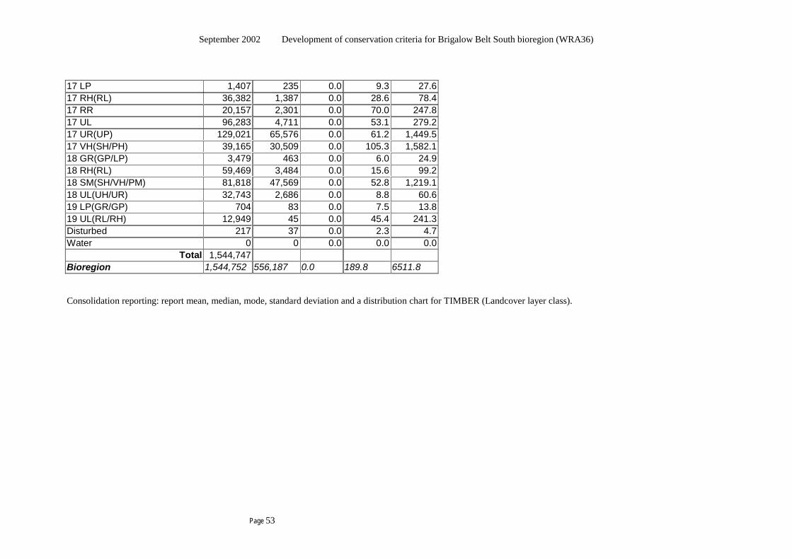
September 2002 Development of conservation criteria for Brigalow Belt South bioregion (WRA36)
Page 53
17 LP 1,407 235 0.0 9.3 27.6 17 RH(RL) 36,382 1,387 0.0 28.6 78.4 17 RR 20,157 2,301 0.0 70.0 247.8 17 UL 96,283 4,711 0.0 53.1 279.2 17 UR(UP) 129,021 65,576 0.0 61.2 1,449.5 17 VH(SH/PH) 39,165 30,509 0.0 105.3 1,582.1 18 GR(GP/LP) 3,479 463 0.0 6.0 24.9 18 RH(RL) 59,469 3,484 0.0 15.6 99.2 18 SM(SH/VH/PM) 81,818 47,569 0.0 52.8 1,219.1 18 UL(UH/UR) 32,743 2,686 0.0 8.8 60.6 19 LP(GR/GP) 704 83 0.0 7.5 13.8 19 UL(RL/RH) 12,949 45 0.0 45.4 241.3 Disturbed 217 37 0.0 2.3 4.7 Water 0 0 0.0 0.0 0.0
Total 1,544,747 Bioregion 1,544,752 556,187 0.0 189.8 6511.8 Consolidation reporting: report mean, median, mode, standard deviation and a distribution chart for TIMBER (Landcover layer class).
September 2002 Development of conservation criteria for Brigalow Belt South bioregion (WRA36)
Page 54
Table A5.1f Criterion reporting format: C3(a) Management priority
COLUMNS = Priority class Tenure sub-totals Total conservation
A conservation B
joint cons’n and prod’n
production A production B negotiable tenure
potentially neg’le ten.
Non-neg’le tenure
ROWS = Vegetation groupings Geomorphic units
Tenure split subtotals - negotiable tenure
- potentially negotiable ten. - non-negotiable tenure
20690500
1085442818
324
47964222494
282118
697
17601 1362344
2443945
2871194
796032
46858 4515980
Total 206905 111686 784254 1380642 2875383 5358870 3.9% 2.1% 14.6% 25.8% 53.7% 100.0%
This data is for the bioregion plus those areas of negotiable land that extend into the buffer. Consolidation reporting: % of bioregion within each class
September 2002 Development of conservation criteria for Brigalow Belt South bioregion (WRA36)
Page 55
Table A5.1g Criterion reporting format: C4(a)-(g) Certainty of conservation management This data is for the bioregion plus those areas of negotiable land that extend into the buffer.
COLUMNS = Certainty group Total Parliament OR Minister no
term Term OR non-Ministerial Other
Neg-able Potential Non-neg Neg-able Potential Non-neg Neg-able Potential Non-neg ROWS = Vegetation groupings area
- Rare and endangered- Vulnerable
- OtherHabitat of particular quality area Wilderness (min. 8000ha NWI>12) area
0 0
0 0
0 0
0 0
0 0
0 0
0 0
0 0
0 0
0 0
Certainty group net area 306022 0 0 458255 0 0 0 0 0 764277 Number of non-Aboriginal cultural heritage sites by significance class: Contributory Local Regional State National
2 19 5 4 0
0 0 0 0 0
0 0 0 0 0
20 41 6 3 3
0 0 0 0 0
0 0 0 0 0
0 0 0 0 0
0 0 0 0 0
0 0 0 0 0
22 60 11 7 3
Number of non-Aboriginal cultural heritage sites- all significance classes
30 0 0 73 0 0 0 0 0 103
Consolidation report: net area and number of sites for each certainty group (all tenures).
September 2002 Development of conservation criteria for Brigalow Belt South bioregion (WRA36)
Page 56
Table A5.1h Criterion reporting format: D(a)-(c) Aboriginal responsibility and influence regarding management of Aboriginal culturally significant places
COLUMNS = Area within which the Aboriginal community has: direct responsibility for
management and maintenance of Aboriginal culturally significant areas therein
direct influence over management and maintenance of Aboriginal culturally significant areas therein
Area covered by geomorphic mapping
Tenure split subtotals - negotiable tenure
- potentially negotiable ten. - non-negotiable tenure
0 ha 0 ha 0 ha
495,430 ha
0 ha 0 ha
724,413 ha
43,551 ha 4,482,564 ha
Total - area - % of bioregion area
0 ha 0% of bioregion
495,430 ha 9.2% of bioregion
5,250,528 ha 98% of bioregion
This data is for the bioregion (ie excluding the buffer). Consolidation report: % of the bioregion within which the Aboriginal community has direct responsibility for … , % of the bioregion within which the Aboriginal community has direct influence over … , and % of the bioregion covered by geomorphic mapping.

September 2002 Development of conservation criteria for Brigalow Belt South bioregion (WRA36)
Page 57
This page left black for insertion of the spreadsheets of Tables A5.1 i (page 1)

September 2002 Development of conservation criteria for Brigalow Belt South bioregion (WRA36)
Page 58
This page left black for insertion of the spreadsheets of Tables A5.1 i (page 2).

September 2002 Development of conservation criteria for Brigalow Belt South bioregion (WRA36)
Page 59
This page left black for insertion of the spreadsheets of Tables A5.1 j (page 1)

September 2002 Development of conservation criteria for Brigalow Belt South bioregion (WRA36)
Page 60
This page left black for insertion of the spreadsheets of Tables A5.1 j (page 2)
September 2002 Development of conservation criteria for Brigalow Belt South bioregion (WRA36)
Page 61
This page left black for insertion of the spreadsheets of Tables A51. k (page 1).
September 2002 Development of conservation criteria for Brigalow Belt South bioregion (WRA36)
Page 62
This page left black for insertion of the spreadsheets of Tables A5.1 k (page 2).

September 2002 Development of conservation criteria for Brigalow Belt South bioregion (WRA36)
Page 63
This page left black for insertion of the spreadsheets of Tables A5.1 l (page 1).
September 2002 Development of conservation criteria for Brigalow Belt South bioregion (WRA36)
Page 64
This page left black for insertion of the spreadsheets of Tables A5.1 l (page 2).

September 2002 Development of conservation criteria for Brigalow Belt South bioregion (WRA36)
Page 65
This page left black for insertion of the spreadsheets of Tables A5.1 m (page 1)

September 2002 Development of conservation criteria for Brigalow Belt South bioregion (WRA36)
Page 66
This page left black for insertion of the spreadsheets of Tables A5.1 m (page 2).
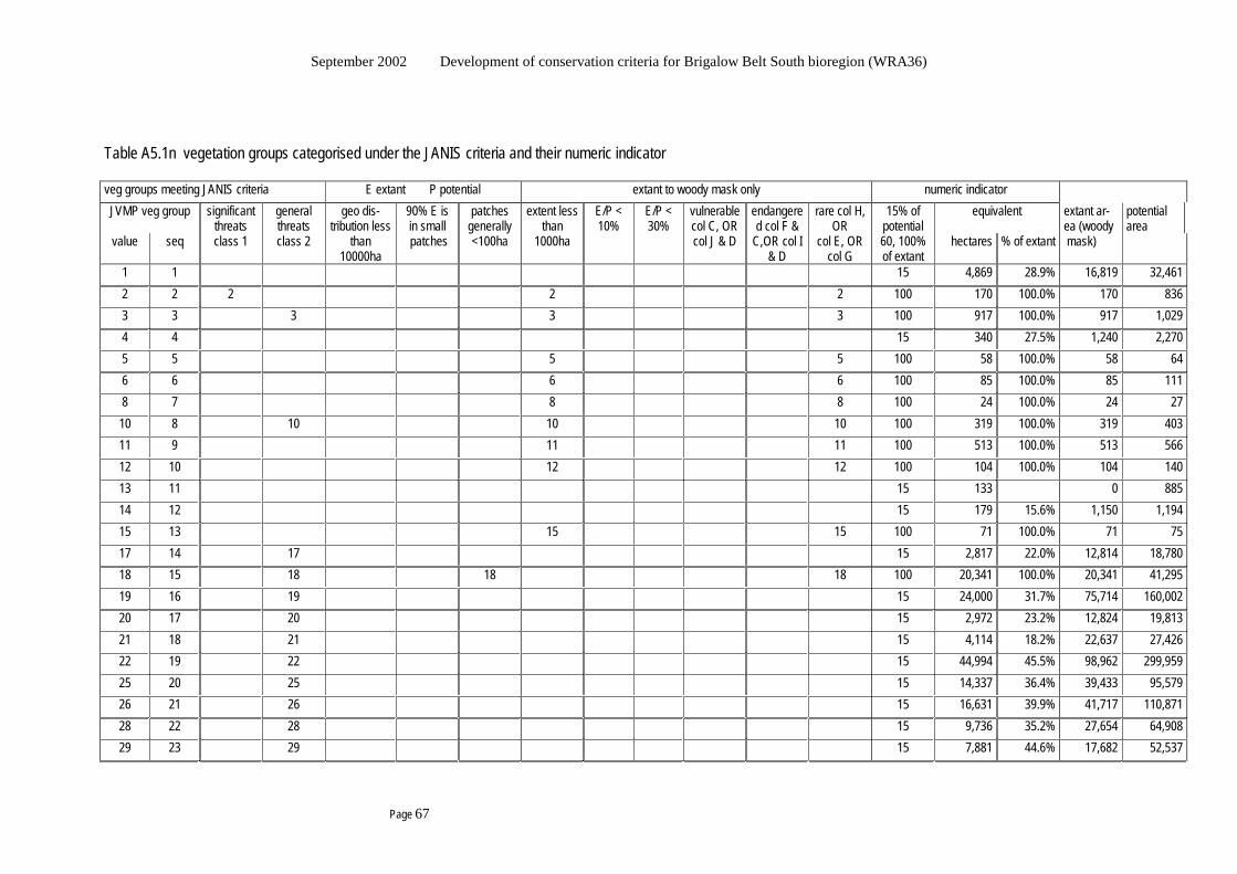
September 2002 Development of conservation criteria for Brigalow Belt South bioregion (WRA36)
Page 67
Table A5.1n vegetation groups categorised under the JANIS criteria and their numeric indicator veg groups meeting JANIS criteria E extant P potential extant to woody mask only numeric indicator JVMP veg group significant
threats general threats
geo dis-tribution less
90% E is in small
patches generally
extent less than
E/P < 10%
E/P < 30%
vulnerable col C, OR
endangered col F &
rare col H, OR
15% of potential
equivalent extant ar-ea (woody
potential area
value seq class 1 class 2 than 10000ha
patches <100ha 1000ha col J & D C,OR col I & D
col E, OR col G
60, 100% of extant
hectares % of extant mask)
1 1 15 4,869 28.9% 16,819 32,461 2 2 2 2 2 100 170 100.0% 170 836 3 3 3 3 3 100 917 100.0% 917 1,029 4 4 15 340 27.5% 1,240 2,270 5 5 5 5 100 58 100.0% 58 64 6 6 6 6 100 85 100.0% 85 111 8 7 8 8 100 24 100.0% 24 27 10 8 10 10 10 100 319 100.0% 319 403 11 9 11 11 100 513 100.0% 513 566 12 10 12 12 100 104 100.0% 104 140 13 11 15 133 0 885 14 12 15 179 15.6% 1,150 1,194 15 13 15 15 100 71 100.0% 71 75 17 14 17 15 2,817 22.0% 12,814 18,780 18 15 18 18 18 100 20,341 100.0% 20,341 41,295 19 16 19 15 24,000 31.7% 75,714 160,002 20 17 20 15 2,972 23.2% 12,824 19,813 21 18 21 15 4,114 18.2% 22,637 27,426 22 19 22 15 44,994 45.5% 98,962 299,959 25 20 25 15 14,337 36.4% 39,433 95,579 26 21 26 15 16,631 39.9% 41,717 110,871 28 22 28 15 9,736 35.2% 27,654 64,908 29 23 29 15 7,881 44.6% 17,682 52,537
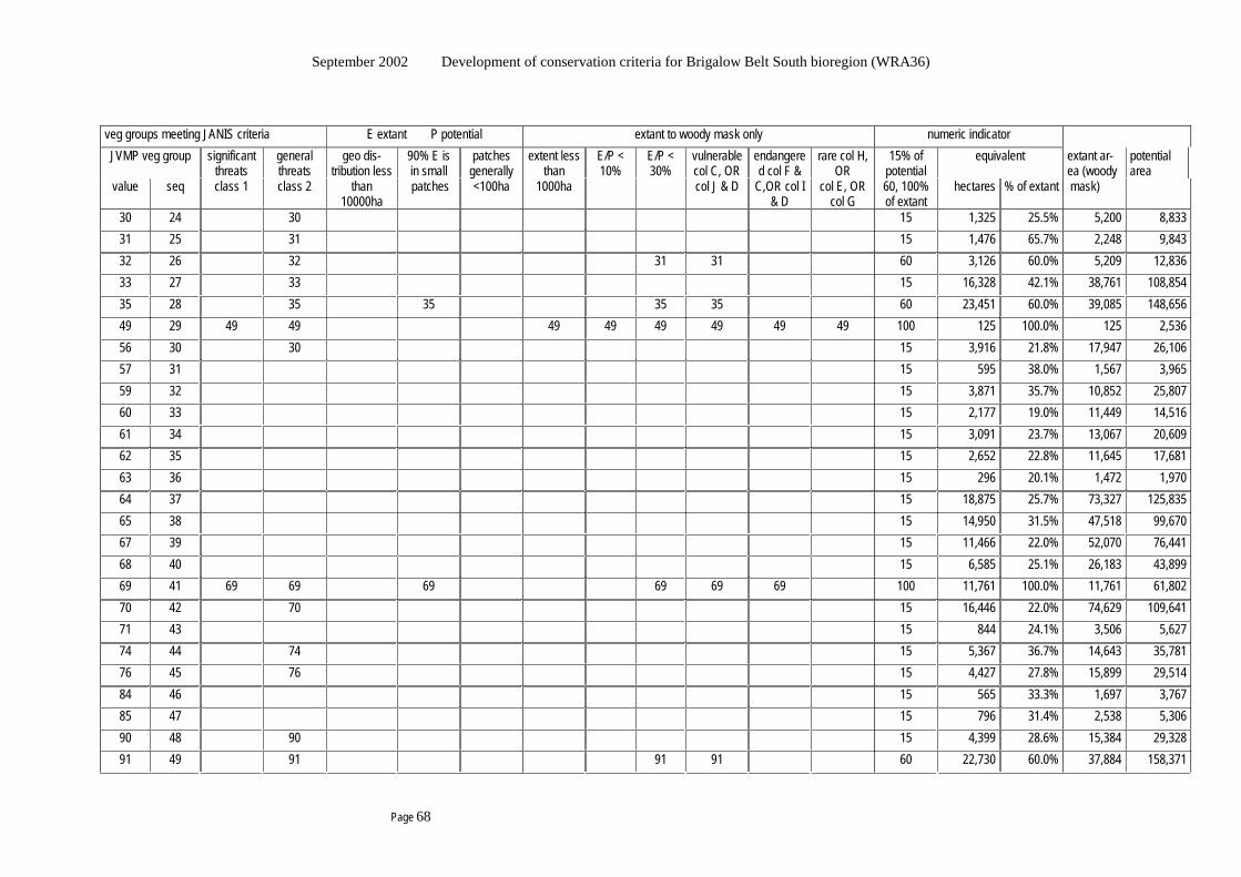
September 2002 Development of conservation criteria for Brigalow Belt South bioregion (WRA36)
Page 68
veg groups meeting JANIS criteria E extant P potential extant to woody mask only numeric indicator JVMP veg group significant
threats general threats
geo dis-tribution less
90% E is in small
patches generally
extent less than
E/P < 10%
E/P < 30%
vulnerable col C, OR
endangered col F &
rare col H, OR
15% of potential
equivalent extant ar-ea (woody
potential area
value seq class 1 class 2 than 10000ha
patches <100ha 1000ha col J & D C,OR col I & D
col E, OR col G
60, 100% of extant
hectares % of extant mask)
30 24 30 15 1,325 25.5% 5,200 8,833 31 25 31 15 1,476 65.7% 2,248 9,843 32 26 32 31 31 60 3,126 60.0% 5,209 12,836 33 27 33 15 16,328 42.1% 38,761 108,854 35 28 35 35 35 35 60 23,451 60.0% 39,085 148,656 49 29 49 49 49 49 49 49 49 49 100 125 100.0% 125 2,536 56 30 30 15 3,916 21.8% 17,947 26,106 57 31 15 595 38.0% 1,567 3,965 59 32 15 3,871 35.7% 10,852 25,807 60 33 15 2,177 19.0% 11,449 14,516 61 34 15 3,091 23.7% 13,067 20,609 62 35 15 2,652 22.8% 11,645 17,681 63 36 15 296 20.1% 1,472 1,970 64 37 15 18,875 25.7% 73,327 125,835 65 38 15 14,950 31.5% 47,518 99,670 67 39 15 11,466 22.0% 52,070 76,441 68 40 15 6,585 25.1% 26,183 43,899 69 41 69 69 69 69 69 69 100 11,761 100.0% 11,761 61,802 70 42 70 15 16,446 22.0% 74,629 109,641 71 43 15 844 24.1% 3,506 5,627 74 44 74 15 5,367 36.7% 14,643 35,781 76 45 76 15 4,427 27.8% 15,899 29,514 84 46 15 565 33.3% 1,697 3,767 85 47 15 796 31.4% 2,538 5,306 90 48 90 15 4,399 28.6% 15,384 29,328 91 49 91 91 91 60 22,730 60.0% 37,884 158,371
September 2002 Development of conservation criteria for Brigalow Belt South bioregion (WRA36)
Page 69
veg groups meeting JANIS criteria E extant P potential extant to woody mask only numeric indicator JVMP veg group significant
threats general threats
geo dis-tribution less
90% E is in small
patches generally
extent less than
E/P < 10%
E/P < 30%
vulnerable col C, OR
endangered col F &
rare col H, OR
15% of potential
equivalent extant ar-ea (woody
potential area
value seq class 1 class 2 than 10000ha
patches <100ha 1000ha col J & D C,OR col I & D
col E, OR col G
60, 100% of extant
hectares % of extant mask)
94 50 94 94 94 94 60 5,278 60.0% 8,796 30,432 96 51 96 96 96 60 17,253 60.0% 28,754 95,239 99 52 99 99 100 159 100.0% 159 174 100 53 100 100 100 146 100.0% 146 192 101 54 101 101 100 496 100.0% 496 552 103 55 15 7,455 49.4% 15,084 49,702 106 56 15 2,430 23.0% 10,570 16,201 107 57 15 4,421 19.4% 22,733 29,473 108 58 15 360 21.4% 1,686 2,403 110 59 15 1,350 29.4% 4,589 8,998 111 60 15 1,438 26.8% 5,369 9,586 112 61 112 15 2,480 40.6% 6,103 16,532 115 62 15 1,048 21.8% 4,815 6,989 116 63 116 15 3,464 31.4% 11,017 23,094 119 64 15 8,363 25.3% 33,077 55,751 121 65 15 2,663 33.7% 7,891 17,751 123 66 15 7,052 25.7% 27,440 47,011 124 67 15 14,151 30.9% 45,857 94,342 126 68 15 7,849 33.3% 23,563 52,325 128 69 15 7,543 26.6% 28,357 50,284 129 70 15 2,046 47.2% 4,339 13,642 130 71 15 36,651 0 244,342 134 72 15 8,578 49.3% 17,388 57,187 136 73 136 136 136 100 6,451 100.0% 6,451 16,416 137 74 137 137 137 60 0 0 1,172 138 75 138 15 432 24.9% 1,737 2,879
September 2002 Development of conservation criteria for Brigalow Belt South bioregion (WRA36)
Page 70
veg groups meeting JANIS criteria E extant P potential extant to woody mask only numeric indicator JVMP veg group significant
threats general threats
geo dis-tribution less
90% E is in small
patches generally
extent less than
E/P < 10%
E/P < 30%
vulnerable col C, OR
endangered col F &
rare col H, OR
15% of potential
equivalent extant ar-ea (woody
potential area
value seq class 1 class 2 than 10000ha
patches <100ha 1000ha col J & D C,OR col I & D
col E, OR col G
60, 100% of extant
hectares % of extant mask)
139 76 139 15 2,679 0 17,860 141 77 141 15 4,739 0 31,596 143 78 15 3,399 0 22,661 149 79 15 12,814 24.7% 51,916 85,427 150 80 15 4,237 28.9% 14,650 28,246 151 81 15 7,454 0 49,695 152 82 15 19,809 19.6% 101,181 132,060 153 83 15 14,247 18.6% 76,679 94,979 154 84 15 2,719 22.9% 11,886 18,129 156 85 15 10,418 17.0% 61,152 69,453 157 86 15 16,747 23.3% 71,867 111,650 158 87 158 158 158 158 60 8,776 60.0% 14,627 49,752 161 88 161 161 161 161 60 7,609 60.0% 12,681 87,523 164 89 164 164 100 9,677 100.0% 9,677 44,627 166 90 166 166 166 166 60 2,156 60.0% 3,593 18,400 167 91 167 167 167 167 167 100 828 100.0% 828 2,559 169 92 169 169 169 169 169 169 169 169 100 271 100.0% 271 4,596 171 93 171 171 171 171 60 995 60.0% 1,658 12,609 172 94 172 172 172 172 60 3,615 60.0% 6,025 44,341 174 95 174 174 174 174 174 174 174 100 4,901 100.0% 4,901 54,434 176 96 176 176 176 176 176 176 176 100 3,114 100.0% 3,114 49,670 178 97 178 178 178 60 1,196 60.0% 1,993 4,677 179 98 179 179 179 179 60 839 60.0% 1,398 10,797 180 99 180 180 180 180 180 180 180 100 3,606 100.0% 3,606 36,606 183 100 183 183 183 60 11,831 60.0% 19,718 150,428 184 101 184 184 184 184 184 184 100 1,579 100.0% 1,579 20,822
September 2002 Development of conservation criteria for Brigalow Belt South bioregion (WRA36)
Page 71
veg groups meeting JANIS criteria E extant P potential extant to woody mask only numeric indicator JVMP veg group significant
threats general threats
geo dis-tribution less
90% E is in small
patches generally
extent less than
E/P < 10%
E/P < 30%
vulnerable col C, OR
endangered col F &
rare col H, OR
15% of potential
equivalent extant ar-ea (woody
potential area
value seq class 1 class 2 than 10000ha
patches <100ha 1000ha col J & D C,OR col I & D
col E, OR col G
60, 100% of extant
hectares % of extant mask)
185 102 185 185 185 185 185 185 185 100 1,663 100.0% 1,663 27,274 187 103 187 187 187 187 187 187 100 13,000 100.0% 13,000 134,150 188 104 188 188 188 188 60 5,559 60.0% 9,266 66,611 190 105 190 190 190 190 60 2,560 60.0% 4,266 19,087 191 106 191 191 191 191 60 15,490 60.0% 25,817 125,283 192 107 192 15 5,195 44.4% 11,696 34,632 193 108 193 193 193 60 816 60.0% 1,361 3,319 194 109 194 194 100 5,436 100.0% 5,436 10,543 195 110 195 195 195 60 14,847 60.0% 24,745 141,127 196 111 196 196 196 196 196 100 3,279 100.0% 3,279 11,367 197 112 197 197 197 60 9,675 60.0% 16,125 98,879 198 113 198 198 198 198 198 198 100 7,324 100.0% 7,324 51,694 199 114 199 199 199 60 13,318 60.0% 22,196 99,508 200 115 200 200 200 200 200 200 100 2,327 100.0% 2,327 15,160 115 115 23 62 0 13 4 8 29 34 11 19 115 747,551 40.0% 1,866,836 5,153,323
15% 65 60% 21 100% 29 sum 115
Notes
1. The classes of Vulnerable, Rare, and Endangered are as defined in JANIS. 2. The data proved unsuitable for meaningful estimation of groups for which the extant distribution is less than 10% of the potential distribution (re
Endangered class). 3. No group with extant area over 100ha had a geographic extent less than 1000ha, using the composite extant layer. 4. The data proved unsuitable for reliable estimation of the size of actual patches, and the expert opinion of Doug Binns and Geoff Robertson was used
to define groups likely to have 90% 0f extant area in small patches, and groups where the extant area is largely in patches less than 100ha.
September 2002 Development of conservation criteria for Brigalow Belt South bioregion (WRA36)
Page 72
This blank page has been inserted here so the next section
appears on the right hand side in double-sided printing.

September 2002 Development of conservation criteria for Brigalow Belt South bioregion (WRA36)
Page 73
Appendix 5.2 Processes threatening each vegetation grouping These criteria require identification of Rare and endangered vegetation, and Vulnerable vegetation under the JANIS (1997) criteria.
A “Vulnerable” vegetation group is one that within the next 25 years is likely to become likely to turn extinct in nature unless the circumstances and factors threatening its extent, survival or evolutionary development cease to operate, in accord with the following:
- The extant area is 30% or less of predicted potential area AND remains subject to threatening processes (2) that present the risk of the foregoing eventuality.
- OR is subject to continuing and significant threatening processes (1) that present the risk of the foregoing eventuality.
A “Rare” vegetation group is based only on analysis of patch sizes.
An “Endangered” vegetation group is one that is likely to become extinct in nature unless the circumstances and factors threatening its extent, survival or evolutionary development cease to operate, in accord with the following:
- The extant area is less than 10% of predicted potential area
- OR the extant distribution is less than 10% of the predicted potential distribution
- OR 90% of the extant area is in “small” patches that are subject to threatening processes (1) and unlikely to persist.
There are several aspects needing quantification:
Which vegetation groups face continuing and significant threatening processes that present the risk of going extinct? This relates to the instances above marked (1). Tables A5.2a and A5.2b present the result from a request to the experts on the technical working group for the vegetation mapping project to nominate continuing significant threatening processes for each vegetation group.
Which vegetation groups are subject to threatening processes likely reduce the extent enough to put them at risk of going extinct? This relates to the instances above marked (2). Tables A5.2a and A5.2b present the result from a request to the experts on the technical working group for the vegetation mapping project to nominate threatening processes for each vegetation group.
What is “small”? “Small” is likely to be different areas for different vegetation groups because their locations and inherent characteristics will vary to such an extent that impinges on this concept. The classification was provided using expert opinion for each group (see table A5.1n).
Twenty three (23) groups were nominated as subject to continuing significant threatening processes, and a further 40 were nominated as subject to the second category of threatening processes. Some adverse processes such as insufficient or excessive fire (intensity, duration, timing, frequency) are operating, but were not all perceived as presenting sufficient risk that the vegetation group would be likely to become extinct. The threats of interest identified were:
- Persistent heavy browsing leading to reduced survival in drought and elimination of propagules
- Removal of all or some key species in concert with removal or suppression of their regeneration
- Replacement through competition from more aggressive species
- Dryland salinity making the location inhospitable through salt
- Insufficient inundation (quantity, duration, timing) leading to poor establishment and survival
Table A5.2a Threatening processes that may operate
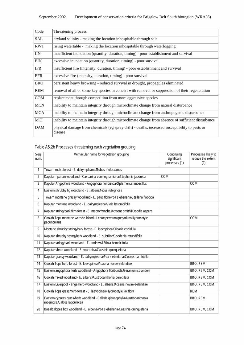
September 2002 Development of conservation criteria for Brigalow Belt South bioregion (WRA36)
Page 74
Code Threatening process
SAL dryland salinity - making the location inhospitable through salt
RWT rising watertable - making the location inhospitable through waterlogging
IIN insufficient inundation (quantity, duration, timing) - poor establishment and survival
EIN excessive inundation (quantity, duration, timing) - poor survival
IFR insufficient fire (intensity, duration, timing) - poor establishment and survival
EFR excessive fire (intensity, duration, timing) - poor survival
BRO persistent heavy browsing - reduced survival in drought, propagules eliminated
REM removal of all or some key species in concert with removal or suppression of their regeneration
COM replacement through competition from more aggressive species
MCN inability to maintain integrity through microclimate change from natural disturbance
MCA inability to maintain integrity through microclimate change from anthropogenic disturbance
MCI inability to maintain integrity through microclimate change from absence of sufficient disturbance
DAM physical damage from chemicals (eg spray drift) - deaths, increased susceptibility to pests or disease
Table A5.2b Processes threatening each vegetation grouping Seq. num.
Vernacular name for vegetation grouping Continuing significant
processes (1)
Processes likely to reduce the extent
(2)
1 Towarri moist forest - E. dalrympleana/Rubus moluccanus
2 Kaputar riparian woodland - Casuarina cunninghamiana/Stephania japonica COM
3 Kaputar Angophora woodland - Angophora floribunda/Oplismenus imbecillus COM
4 Eastern shrubby fig woodland - E. albens/Ficus rubiginosa
5 Towarri montane grassy woodland - E. pauciflora/Poa sieberiana/Stellaria flaccida
6 Kaputar montane woodland - E. dalrympleana/Viola betonicifolia
7 Kaputar stringybark fern forest - E. macrorhyncha/Acmena smithii/Doodia aspera
8 Coolah Tops montane wet shrubland - Leptospermum gregarium/Hydrocotyle peduncularis
COM
9 Montane shrubby stringybark forest - E. laevopinea/Olearia viscidula
10 Kaputar shrubby stringybark woodland - E. subtilior/Goodenia rotundifolia
11 Kaputar stringybark woodland - E. andrewsii/Viola betonicifolia
12 Kaputar shrub woodland - E. volcanica/Cassinia quinquefaria
13 Kaputar grassy woodland - E. dalrympleana/Poa sieberiana/Coprosma hirtella
14 Coolah Tops herb forest - E. laevopinea/Acaena novae-zelandiae BRO, REM
15 Eastern angophora herb woodland - Angophora floribunda/Geranium solanderi BRO, REM, COM
16 Coolah mixed woodland - E. albens/Austrodanthonia penicillata BRO, REM, COM
17 Eastern Liverpool Range herb woodland - E. albens/Acaena novae-zelandiae BRO, REM, COM
18 Coolah Tops grass/herb forest - E. laevopinea/Hydrocotyle laxiflora REM
19 Eastern cypress grass/herb woodland - Callitris glaucophylla/Austrodanthonia racemosa/Calotis lappulacea
BRO, REM
20 Basalt slopes box woodland - E. albens/Poa sieberiana/Cassinia quinquefaria BRO, REM, COM
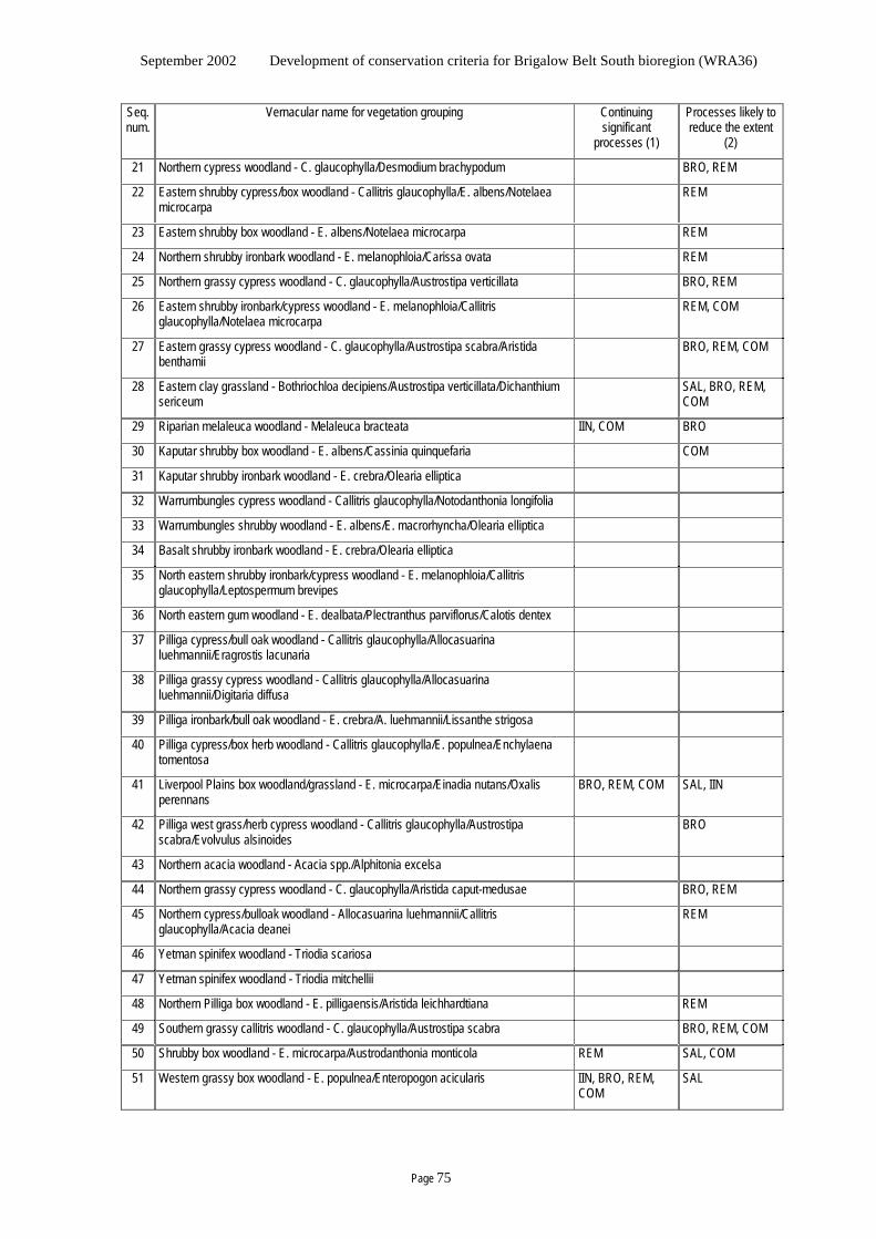
September 2002 Development of conservation criteria for Brigalow Belt South bioregion (WRA36)
Page 75
Seq. num.
Vernacular name for vegetation grouping Continuing significant
processes (1)
Processes likely to reduce the extent
(2)
21 Northern cypress woodland - C. glaucophylla/Desmodium brachypodum BRO, REM
22 Eastern shrubby cypress/box woodland - Callitris glaucophylla/E. albens/Notelaea microcarpa
REM
23 Eastern shrubby box woodland - E. albens/Notelaea microcarpa REM
24 Northern shrubby ironbark woodland - E. melanophloia/Carissa ovata REM
25 Northern grassy cypress woodland - C. glaucophylla/Austrostipa verticillata BRO, REM
26 Eastern shrubby ironbark/cypress woodland - E. melanophloia/Callitris glaucophylla/Notelaea microcarpa
REM, COM
27 Eastern grassy cypress woodland - C. glaucophylla/Austrostipa scabra/Aristida benthamii
BRO, REM, COM
28 Eastern clay grassland - Bothriochloa decipiens/Austrostipa verticillata/Dichanthium sericeum
SAL, BRO, REM, COM
29 Riparian melaleuca woodland - Melaleuca bracteata IIN, COM BRO
30 Kaputar shrubby box woodland - E. albens/Cassinia quinquefaria COM
31 Kaputar shrubby ironbark woodland - E. crebra/Olearia elliptica
32 Warrumbungles cypress woodland - Callitris glaucophylla/Notodanthonia longifolia
33 Warrumbungles shrubby woodland - E. albens/E. macrorhyncha/Olearia elliptica
34 Basalt shrubby ironbark woodland - E. crebra/Olearia elliptica
35 North eastern shrubby ironbark/cypress woodland - E. melanophloia/Callitris glaucophylla/Leptospermum brevipes
36 North eastern gum woodland - E. dealbata/Plectranthus parviflorus/Calotis dentex
37 Pilliga cypress/bull oak woodland - Callitris glaucophylla/Allocasuarina luehmannii/Eragrostis lacunaria
38 Pilliga grassy cypress woodland - Callitris glaucophylla/Allocasuarina luehmannii/Digitaria diffusa
39 Pilliga ironbark/bull oak woodland - E. crebra/A. luehmannii/Lissanthe strigosa
40 Pilliga cypress/box herb woodland - Callitris glaucophylla/E. populnea/Enchylaena tomentosa
41 Liverpool Plains box woodland/grassland - E. microcarpa/Einadia nutans/Oxalis perennans
BRO, REM, COM SAL, IIN
42 Pilliga west grass/herb cypress woodland - Callitris glaucophylla/Austrostipa scabra/Evolvulus alsinoides
BRO
43 Northern acacia woodland - Acacia spp./Alphitonia excelsa
44 Northern grassy cypress woodland - C. glaucophylla/Aristida caput-medusae BRO, REM
45 Northern cypress/bulloak woodland - Allocasuarina luehmannii/Callitris glaucophylla/Acacia deanei
REM
46 Yetman spinifex woodland - Triodia scariosa
47 Yetman spinifex woodland - Triodia mitchellii
48 Northern Pilliga box woodland - E. pilligaensis/Aristida leichhardtiana REM
49 Southern grassy callitris woodland - C. glaucophylla/Austrostipa scabra BRO, REM, COM
50 Shrubby box woodland - E. microcarpa/Austrodanthonia monticola REM SAL, COM
51 Western grassy box woodland - E. populnea/Enteropogon acicularis IIN, BRO, REM, COM
SAL
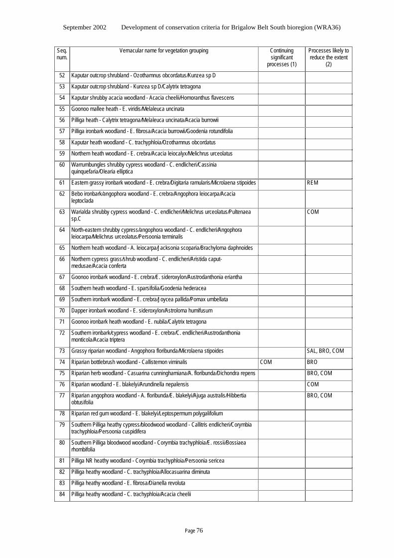
September 2002 Development of conservation criteria for Brigalow Belt South bioregion (WRA36)
Page 76
Seq. num.
Vernacular name for vegetation grouping Continuing significant
processes (1)
Processes likely to reduce the extent
(2)
52 Kaputar outcrop shrubland - Ozothamnus obcordatus/Kunzea sp D
53 Kaputar outcrop shrubland - Kunzea sp D/Calytrix tetragona
54 Kaputar shrubby acacia woodland - Acacia cheelii/Homoranthus flavescens
55 Goonoo mallee heath - E. viridis/Melaleuca uncinata
56 Pilliga heath - Calytrix tetragona/Melaleuca uncinata/Acacia burrowii
57 Pilliga ironbark woodland - E. fibrosa/Acacia burrowii/Goodenia rotundifolia
58 Kaputar heath woodland - C. trachyphloia/Ozothamnus obcordatus
59 Northern heath woodland - E. crebra/Acacia leiocalyx/Melichrus urceolatus
60 Warrumbungles shrubby cypress woodland - C. endlicheri/Cassinia quinquefaria/Olearia elliptica
61 Eastern grassy ironbark woodland - E. crebra/Digitaria ramularis/Microlaena stipoides REM
62 Bebo ironbark/angophora woodland - E. crebra/Angophora leiocarpa/Acacia leptoclada
63 Warialda shrubby cypress woodland - C. endlicheri/Melichrus urceolatus/Pultenaea sp.C
COM
64 North-eastern shrubby cypress/angophora woodland - C. endlicheri/Angophora leiocarpa/Melichrus urceolatus/Persoonia terminalis
65 Northern heath woodland - A. leiocarpa/Jacksonia scoparia/Brachyloma daphnoides
66 Northern cypress grass/shrub woodland - C. endlicheri/Aristida caput-medusae/Acacia conferta
67 Goonoo ironbark woodland - E. crebra/E. sideroxylon/Austrodanthonia eriantha
68 Southern heath woodland - E. sparsifolia/Goodenia hederacea
69 Southern ironbark woodland - E. crebra/Joycea pallida/Pomax umbellata
70 Dapper ironbark woodland - E. sideroxylon/Astroloma humifusum
71 Goonoo ironbark heath woodland - E. nubila/Calytrix tetragona
72 Southern ironbark/cypress woodland - E. crebra/C. endlicheri/Austrodanthonia monticola/Acacia triptera
73 Grassy riparian woodland - Angophora floribunda/Microlaena stipoides SAL, BRO, COM
74 Riparian bottlebrush woodland - Callistemon viminalis COM BRO
75 Riparian herb woodland - Casuarina cunninghamiana/A. floribunda/Dichondra repens BRO, COM
76 Riparian woodland - E. blakelyi/Arundinella nepalensis COM
77 Riparian angophora woodland - A. floribunda/E. blakelyi/Ajuga australis/Hibbertia obtusifolia
BRO, COM
78 Riparian red gum woodland - E. blakelyi/Leptospermum polygalifolium
79 Southern Pilliga heathy cypress/bloodwood woodland - Callitris endlicheri/Corymbia trachyphloia/Persoonia cuspidifera
80 Southern Pilliga bloodwood woodland - Corymbia trachyphloia/E. rossii/Bossiaea rhombifolia
81 Pilliga NR heathy woodland - Corymbia trachyphloia/Persoonia sericea
82 Pilliga heathy woodland - C. trachyphloia/Allocasuarina diminuta
83 Pilliga heathy woodland - E. fibrosa/Dianella revoluta
84 Pilliga heathy woodland - C. trachyphloia/Acacia cheelii
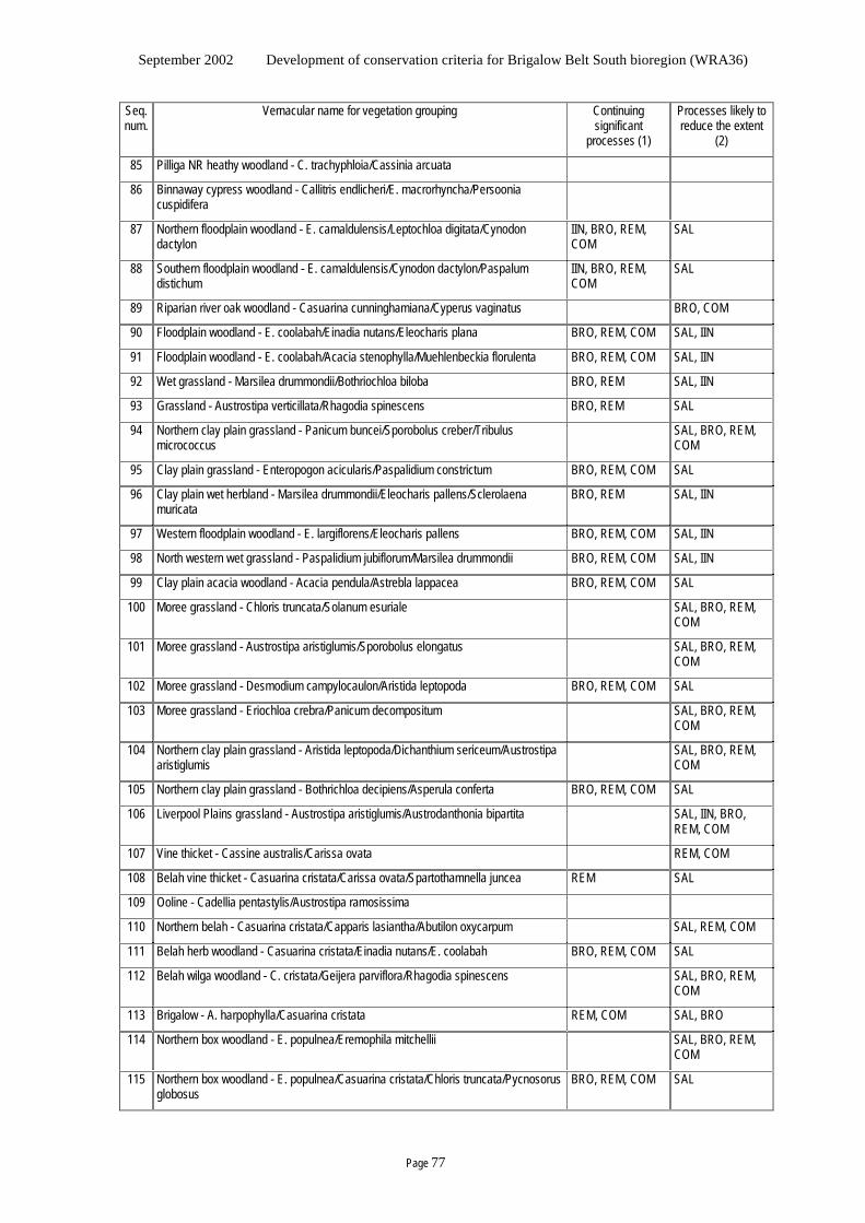
September 2002 Development of conservation criteria for Brigalow Belt South bioregion (WRA36)
Page 77
Seq. num.
Vernacular name for vegetation grouping Continuing significant
processes (1)
Processes likely to reduce the extent
(2)
85 Pilliga NR heathy woodland - C. trachyphloia/Cassinia arcuata
86 Binnaway cypress woodland - Callitris endlicheri/E. macrorhyncha/Persoonia cuspidifera
87 Northern floodplain woodland - E. camaldulensis/Leptochloa digitata/Cynodon dactylon
IIN, BRO, REM, COM
SAL
88 Southern floodplain woodland - E. camaldulensis/Cynodon dactylon/Paspalum distichum
IIN, BRO, REM, COM
SAL
89 Riparian river oak woodland - Casuarina cunninghamiana/Cyperus vaginatus BRO, COM
90 Floodplain woodland - E. coolabah/Einadia nutans/Eleocharis plana BRO, REM, COM SAL, IIN
91 Floodplain woodland - E. coolabah/Acacia stenophylla/Muehlenbeckia florulenta BRO, REM, COM SAL, IIN
92 Wet grassland - Marsilea drummondii/Bothriochloa biloba BRO, REM SAL, IIN
93 Grassland - Austrostipa verticillata/Rhagodia spinescens BRO, REM SAL
94 Northern clay plain grassland - Panicum buncei/Sporobolus creber/Tribulus micrococcus
SAL, BRO, REM, COM
95 Clay plain grassland - Enteropogon acicularis/Paspalidium constrictum BRO, REM, COM SAL
96 Clay plain wet herbland - Marsilea drummondii/Eleocharis pallens/Sclerolaena muricata
BRO, REM SAL, IIN
97 Western floodplain woodland - E. largiflorens/Eleocharis pallens BRO, REM, COM SAL, IIN
98 North western wet grassland - Paspalidium jubiflorum/Marsilea drummondii BRO, REM, COM SAL, IIN
99 Clay plain acacia woodland - Acacia pendula/Astrebla lappacea BRO, REM, COM SAL
100 Moree grassland - Chloris truncata/Solanum esuriale SAL, BRO, REM, COM
101 Moree grassland - Austrostipa aristiglumis/Sporobolus elongatus SAL, BRO, REM, COM
102 Moree grassland - Desmodium campylocaulon/Aristida leptopoda BRO, REM, COM SAL
103 Moree grassland - Eriochloa crebra/Panicum decompositum SAL, BRO, REM, COM
104 Northern clay plain grassland - Aristida leptopoda/Dichanthium sericeum/Austrostipa aristiglumis
SAL, BRO, REM, COM
105 Northern clay plain grassland - Bothrichloa decipiens/Asperula conferta BRO, REM, COM SAL
106 Liverpool Plains grassland - Austrostipa aristiglumis/Austrodanthonia bipartita SAL, IIN, BRO, REM, COM
107 Vine thicket - Cassine australis/Carissa ovata REM, COM
108 Belah vine thicket - Casuarina cristata/Carissa ovata/Spartothamnella juncea REM SAL
109 Ooline - Cadellia pentastylis/Austrostipa ramosissima
110 Northern belah - Casuarina cristata/Capparis lasiantha/Abutilon oxycarpum SAL, REM, COM
111 Belah herb woodland - Casuarina cristata/Einadia nutans/E. coolabah BRO, REM, COM SAL
112 Belah wilga woodland - C. cristata/Geijera parviflora/Rhagodia spinescens SAL, BRO, REM, COM
113 Brigalow - A. harpophylla/Casuarina cristata REM, COM SAL, BRO
114 Northern box woodland - E. populnea/Eremophila mitchellii SAL, BRO, REM, COM
115 Northern box woodland - E. populnea/Casuarina cristata/Chloris truncata/Pycnosorus globosus
BRO, REM, COM SAL

September 2002 Development of conservation criteria for Brigalow Belt South bioregion (WRA36)
Page 78
September 2002 Development of conservation criteria for Brigalow Belt South bioregion (WRA36)
Page 79
Appendix 5.3 Habitat of particular quality for “at risk” species
JANIS “high quality habitat” criterion
JANIS criterion (5) is that the reserve system should seek to maximise the area of high quality habitat for all known elements of biodiversity wherever practical, but with particular reference to:
- The special needs of rare, vulnerable or endangered species
- Special groups of organisms such as species with complex habitat requirements or migratory or mobile species
- Areas of high species diversity, natural refugia for flora and fauna, and centres of endemism
- Those species whose distributions and habitat requirements are not well correlated with any particular forest ecosystem.
The purpose for this criterion is to identify areas with specific characteristics with a view to including them as far as practical in the reserve system “so that, to the extent practicable, all elements of biodiversity have the opportunity for expression, but with particular emphasis on those elements of biodiversity that are dependant on reservation for protection” (JANIS, 1997). The outcome for areas identified and not already within a dedicated conservation reserve is that they would be considered for change in security of boundaries (such as a tenure change or a covenant on title) and change in management regimes (ie limiting or excluding any focus on production of natural resources or extractives).
Confidence of particular quality of the habitat Such changes are potentially significant, and it is incumbent on the implementation to include only those areas that can be identified with confidence to be of particular quality for the species concerned. For species dependant on reservation for protection the standard would be reasonable confidence, for other species the standard would be high confidence.
Confidence encompasses rigour in gathering data, objectivity in design and analysis, and precision in the resulting “models”. Data needs to be defendable for its reliability, objectivity, transparency and rigour.
Particular quality infers more than simply a general description that might be readily satisfied in areas set aside by vegetation grouping, and more than just the modelled extent or distribution. It places the focus on specific habitat considerations peculiar to or concentrated in the areas and that contribute to survival of the species. Obviously this is a challenge because there is limited understanding about many of the threatened species, and because this involves a value judgement.
Descriptions that seem too general might be such as:
- woodland containing tussocks, branches and rocks
- open forest with a dense cover of tall native grasses and a shrub layer in gullies
Modelling
For modelled distributions, areas with high probability (say at least 75%) of occurrence might seem logical, particularly where they intersect with features of known value for the species. However, caution is needed. Models should apply variables that relate to the biology of the species, otherwise the model may portray statistically defined entities that have no ecological relationship to the species (Burgmann and Lindenmayer, 1998). In such cases the apparent relationship might be
September 2002 Development of conservation criteria for Brigalow Belt South bioregion (WRA36)
Page 80
coincidental or the result of historical circumstances or transient structural features, and could actually be sub-optimal habitat. The same applies to modelling “communities”. Modelling for communities can easily simply agglomerate species that have similar habitat or overlapping distributions, but which do not have any specific ecological interaction or interdependence (Blair, 1982).
Spatial data availability
Application of the criterion dictates that the habitat so identified must be spatially explicit and available to the deliberations. Thus, habitat descriptions such as “caves”, or “damp sites on riverbanks” or “exfoliating rock outcrops and rocky hills”, notwithstanding being rather general, are not available in spatial data sets and thus are unhelpful.
Data sources NPWS advised that the fauna data sought should be available from the Brigalow Belt South bioregion assessment reports for the Response To Disturbance And Land Management Practices and Fauna Survey And Modelling projects. These and the four other reports available at the time [Targeted Flora Survey And Modelling report, An investigation into the ecology of the eastern pygmy possum (Cercartetus nanus) report, An investigation of glossy black cockatoo ecology in western New South Wales report, and An investigation into the ecology of the pale-headed snake (Holocephalus bitorquata) report], as well as a review of Smith and van der Lee (1992), were used as the basis for this analysis.
Application of the data to the criterion elements A preliminary analysis was undertaken as follows.
1. The special needs of rare, vulnerable or endangered species
JANIS does not define “rare, vulnerable and endangered” species. The Threatened Species Conservation Act lists species considered by the appointed scientific committee to be “endangered” and “vulnerable” species in New South Wales. It seems appropriate to adopt these lists as the only species warranting consideration under this item. The above reports do list other species of conservation concern, however these concerns appear in the main to relate to issues not directly related to inclusion of specific areas in the reserve system (beyond that for vegetation groups) on “negotiable” public land. The main concerns appear to include elimination or substantial degradation of the key vegetation, river flow regimes, and predation. None of these additional species appears to warrant inclusion in this item.
2. Special groups of organisms such as species with complex habitat requirements or migratory or mobile species
Complex habitat needs is a rather different consideration to narrow habitat specificity (it may well be a subset of narrow habitat requirements), and in the absence of a definition requires a value judgement. No additional species could be identified relevant to this group (1) for which there was sufficient information to confidently nominate habitat of particular quality for which spatial data is likely to be available in digital form for the deliberations and (2) that would benefit from reservation of that habitat.
3. Areas of high species diversity, natural refugia for flora and fauna, and centres of endemism
Areas of high species diversity and endemism nominated in the reports are Coolah Tops, the Warrumbungles, and the Pilliga. Unfortunately no specifics are given – no spatial delineation is provided and no particular habitats identified. Thus the nomination is too vague for incorporation here. The Warrumbungles is already a dedicated reserve, and Coolah Tops has been the subject of a government decision that resulted in a high proportion of it being a
September 2002 Development of conservation criteria for Brigalow Belt South bioregion (WRA36)
Page 81
dedicated reserve. Coolah Tops and the Warrumbungles have unique physical and geological features that explain their higher species diversity. There seems little advantage trying to include them here as they are already largely in dedicated reserve and are most unlikely to be revoked. The Pilliga exceeds half a million hectares, and is mostly Nature Reserve and State Forest. Calling this an area of high species diversity and endemism seems too broad and generalised to be meaningful for adoption under this criterion. It will be a key focus in the deliberations, and will feature in considerations for other criteria relating to the reserve system. Thus the Pilliga is not included under this item.
4. Those species whose distributions and habitat requirements are not well correlated with any particular forest ecosystem.
In one sense a large proportion of species (perhaps most fauna) are likely to have distributions and habitat requirements that are not well correlated with any particular ecosystem. It appears that the intent of this component is rather more limited that simply capturing all those species, and the intent is taken as targeting those species considered to have narrow habitat requirements and that are unlikely to be adequately catered for through the general vegetation criteria.
No additional species could be identified relevant to this group (1) for which there was sufficient information to confidently nominate habitat of particular quality for which spatial data is likely to be available in digital form for the deliberations and (2) that would benefit from reservation of that habitat.
5. Other elements of biodiversity
In terms of species, the foregoing reports focussed only on vertebrate terrestrial fauna and vascular plants. No relevant information for this criterion is available regarding aquatic or invertebrate fauna, non-vascular plants, fungi, prokaryotae or protoctista.
• The Fauna Survey And Modelling project proposes four faunal communities: Northern, Central sandstone, Eastern, and Depauperate. These appear very broad and rather vague, with no evidence that they qualify as communities, and no tight relationship to specific habitat was identified. Only a very broad association with quite general vegetation was nominated. Thus these appear inappropriate for inclusion in this criterion.
• The Targeted Flora Survey And Modelling report nominates some vegetation communities. However there appear a number of shortcomings (such as sampling bias and lack of ecological relationship) and the veracity of the process (including the methodology, and the levels selected in the PATN analysis) does not appear to have been afforded thorough external review. These proposed communities appear inappropriate for this criterion at this stage. The derivation of vegetation groupings provided by the Joint Vegetation Mapping project seem the more appropriate units to consider as the vegetation biota elements at this time.
• The Threatened Species Conservation Act schedules nominate a number of “endangered ecological communities”, being (sourced from the Response To Disturbance And Land Management Practices report):
- Bluegrass dominant grasslands of the Brigalow Belt bioregions
- Brigalow
- Ooline community in the Nandewar and Brigalow Belt South bioregions
- Carbeen open forest community in the Darling River Plains and Brigalow Belt South bioregions
- Native vegetation on grey cracking clay soils of the Liverpool Plains
- Semi-evergreen vine thicket in the Brigalow Belt South and Nandewar bioregions
- White box, yellow box, blakely’s red gum woodland (listed as grassy white box woodland)
September 2002 Development of conservation criteria for Brigalow Belt South bioregion (WRA36)
Page 82
These are only defined using rather general terms, and there is no spatial data to identify these communities. In some cases they are very broad. There is no information on the specific habitat requirements of these, and there is no way to identify habitat of particular quality. Thus they cannot be included in this criterion at this time.
The only biotic entities emerging from the above as warranting consideration are the Threatened species. For each, habitat requirements were noted where they were relatively specific and narrow. Where models were provided in the foregoing reports, the confidence is given as the deviance and for flora the overpredict index. Table A5.3a shows these data.
The deviance is the proportion of the variation in the data that is explained by the model. For natural systems, deviance would not be expected to approach 100%. However, if a model explains less that say 2/3 of the variation in the data then one does not have high confidence in its ability to identify habitat for the modelled entity and seems inappropriate for this criterion.
The overpredict index is a measure of the predictive capacity of the model. The precise nature of this index is not clear from the Targeted Flora Survey And Modelling report, however it seems that 1 is good and more than 6 is poor. At face value, a model with more than say 2 or 3 would be inappropriate for this criterion.
Also, the models simply predict species distribution, and do not indicate habitat of particular quality for the species.
Results The information was subjectively evaluated, and each biotic entity assessed to ascertain appropriateness for inclusion in this criterion by virtue of:
(a) There is sufficient information to confidently nominate habitat of particular quality for which spatial data is likely to be available in digital form for the deliberations and
(b) The entity would benefit from reservation of that habitat.
Table A5.3a summarises the outcome. The conclusion is that in the above reports there appears insufficient information to confidently support nomination of habitat of particular quality for which spatial data is likely to be available in digital form for the deliberations for biotic entities that would benefit from reservation of that habitat.
Discussion
Given the intended use of this criterion, it seems inappropriate to try to force entities to “make the grade” in the absence of a defendable case. It seems the data is not available, at least in a form that readily allows inclusion of any biotic entity.
One option given consideration relates to entities that are known from only a few sites. To implement this, a reasonable confidence that it exists only at the few sites is required, so as to avoid potential misrepresentation of entities that are simple little known. Ideally the entity would have been comprehensively surveyed across the potential range in a systematic (habitat independent) way to obtain good presence/absence data. At face value, Bertya opponens might qualify, though it appears to be disturbance dependant, and may not require reservation. In contrast, Philotheca ericifolia seems to be turning up in more and more places, perhaps having been mis-identified previously, evidencing the substantial knowledge deficiencies that may exist. However, the above reports do not seem to provide sufficient information to allow this assessment.
The foregoing preliminary analysis of the data was referred to the experts on the technical working groups for the vegetation, flora and fauna survey and mapping projects. The responses all concurred that the data available does not permit the spatially explicit identification of areas of
September 2002 Development of conservation criteria for Brigalow Belt South bioregion (WRA36)
Page 83
habitat of particular quality for species where reservation would be meaningful. Therefore the result for this criterion at this point in time is NIL.
Some observations emerging from the analysis may aid understanding of this conclusion. In many instances the habitat resources of particular interest for threatened species appear to operate at a fine scale, and are not necessarily related to particular vegetation groupings or to other spatial data available. For example, the glossy black cockatoo appears to favour areas with Allocasuarina, water supply (particularly over summer) and nesting trees. The eastern pygmy possum appears to occupy a wide range of vegetation types and seems to be influenced by the presence of nectar and pollen sources. It is likely that the pale-headed snake requires areas close to water sources with large trees with hollows and decorticating bark. A pertinent overseas example is that in the closed forests of the southern Appalacians many reptile species occur at low densities and depend upon natural disturbance to create ephemeral patches of suitable habitat (Greenberg, 2001). This suggests that such species are more readily conserved by learning more about their ecological interactions and managing to optimise in time and space across the landscape those habitat resources that satisfy their ecological requirements. It appears that reserving areas with particular vegetation of itself may provide little real improvement for conservation of such species.
The issues of scale of data and details for the specific habitat requirements of species are thus pivotal. MacNally et al. (2000) and Soderquist and MacNally (2000) looked at the conservation value of mesic gullies in dry forest landscapes. They concluded that “high quality habitat” (as evidenced by higher population densities and reproductive success) for arboreal mammals (eg possums) in dry forest landscapes is not simply the gullies therein, it was the areas exhibiting more moisture being present (permanent flow, or collects and accumulates enough to have a relatively moist environment) AND accumulated alluvial soil – that results in:
- Moist alluvial gullies amid a drier landscape.
- Different microclimate and vegetation compared to the surrounding areas.
- More vigorous and sustained growth: larger trees (therefore more hollows) and more nutritious foliage, sustained through drought and with faster recovery after drought.
This highlights the role of fine scale factors in defining habitat of particular quality for any species.
September 2002 Development of conservation criteria for Brigalow Belt South bioregion (WRA36)
Page 84
Table A5.3a Evaluation for habitat of particular quality
species of interest No. reason for being of interest habitat of particular quality for this species model appropriate of TSC Act complex migratory not well that provides crucial habitat features devi- over- to reco E endang'd habitat or mobile correlated or natural refugia ance predict include? -rds V vulnerable needs with v/grp (other than generalised or generic aspects) rating Booroolong Frog Litoria booroolongensis 42 E rocky (mountain?) streams last recorded
1972 N
Eastern Cave Bat Vespadelus troughtoni 30 V caves N Yellow-bellied Sheathtail Bat
Saccolaimus flaviventrus 55 V 25% N
Greater Long-eared Bat Nyctophilus timoriensis 134 V 24% N Common Bent-wing Bat Miniopterus schreibersii 16 V 41% N Little Pied Bat Chalinolobus picatus 36 V hollows 19% N Large-eared Pied Bat Chalinolobus dwyeri 57 V caves (sandstone outcrops?) 16% N Greater Broad-nosed Bat Scoteanax rueppellii 7 V N Eastern False Pipistrelle Falsistrellus tasmaniensis 18 V N Malleefowl Leipoa ocellata 80 E N Plains-wanderer Pedionomus torquatus 2 E N Squatter Pigeon Geophaps scripta 2 E N Black-tailed Godwit Limosa limosa 1 V N Painted Snipe Rostratula benghalensis 3 V wetlands with tall grass N Bush Stone-curlew Burhinus grallarius 34 E N Australian Bustard Ardeotis australis 11 E N Brolga Grus rubicunda 46 V N Black-necked Stork Ephippiorhynchus
asiaticus 11 E wetlands, occasionally grassland and
wodland N
Black Bittern Ixobrychus flavicollis 1 V N Australasian Bittern Botaurus poiciloptilus 8 V wetlands with tall dense veg N Magpie Goose Anseranas semipalmata 3 V N Freckled Duck Stictonetta naevosa 13 V aquatic habitats N
September 2002 Development of conservation criteria for Brigalow Belt South bioregion (WRA36)
Page 85
species of interest No. reason for being of interest habitat of particular quality for this species model appropriate of TSC Act complex migratory not well that provides crucial habitat features devi- over- to reco E endang'd habitat or mobile correlated or natural refugia ance predict include? -rds V vulnerable needs with v/grp (other than generalised or generic aspects) rating Blue-billed Duck Oxyura australis 16 V aquatic habitats N Square-tailed Kite Lophoictinia isura 59 V N Black-breasted Buzzard Hamirostra
melanosternon 5 V wetland, watercourse, floodplain N
Grey Falcon Falco hypoleucos 8 V N Barking Owl Ninox connivens 103 V major watercourses & wetland systems with
riparian veg 32% N
Powerful Owl Ninox strenua 15 V N Masked Owl Tyto novaehollandiae 48 V N Grass Owl Tyto capensis 4 V open tussock grassland/marsh N Glossy Black-Cockatoo Calyptorhynchus lathami 446 V ??? areas with Allocasuarina, water supply
(particularly over summer) and nesting trees 21% N
Major Mitchell's Cockatoo Cacatua leadbeateri 21 V N Superb Parrot Polytelis swainsonii 37 V YES nomadic riparian RRG with hollows, box woodland for
feeding N
Turquoise Parrot Neophema pulchella 430 V 26% N Swift Parrot Lathamus discolor 3 V YES N Gilbert's Whistler Pachycephala inornata 7 V N Grey-crowned Babbler Pomatostomus
temporalis 553 V 22% N
Speckled Warbler Sericornis sagittatus 742 V woodland containing tussocks, branches and rocks
26% N
Brown Treecreeper Climacteris picumnus 1046 V 15% N Black-chinned Honeyeater
Melithreptus gularis 64 V N
Painted Honeyeater Grantiella picta 62 V 75% N Pied Honeyeater Certhionyx variegatus 1 V N
September 2002 Development of conservation criteria for Brigalow Belt South bioregion (WRA36)
Page 86
species of interest No. reason for being of interest habitat of particular quality for this species model appropriate of TSC Act complex migratory not well that provides crucial habitat features devi- over- to reco E endang'd habitat or mobile correlated or natural refugia ance predict include? -rds V vulnerable needs with v/grp (other than generalised or generic aspects) rating Regent Honeyeater Xanthomyza phrygia 136 E nomadic N Spotted-tailed Quoll Dasyurus maculatus 10 V N Common Planigale Planigale maculata 6 V N Stripe-faced Dunnart Sminthopsis macroura 13 V N Squirrel Glider Petaurus norfolcensis 51 V 10% N Eastern Pygmy-possum Cercartetus nanus 28 V N Koala Phascolarctos cinereus 504 V 46% N Rufous Bettong Aepyprymnus rufescens 1 V open forest , dense cover of tall native
grasses, shrub layer in gullies only N
Brush-tailed Rock-wallaby
Petrogale penicillata 22 V open grassy forest for feeding with dense understorey for shelter
N
Black-striped Wallaby Macropus dorsalis 33 E N Pilliga Mouse Pseudomys pilligaensis 157 V 32% N Anomalopus mackayi 36 E N Border Thick-tailed Gecko
Underwoodisaurus sphyrurus
18 V exfoliating rock outcrops and rocky hills N
Pink-tailed Worm Lizard Aprasia parapulchella 1 V N Pale-headed Snake Hoplocephalus
bitorpuatus 108 V areas close to water sources with large trees
with hollows and decorticating bark N
Stephen's Banded Snake Hoplocephalus stephensii 3 V N *** for the flora species modelled, the number of records is the number used in the modelling Asperula asthenes Rubiaceae 1 V damp sites on riverbanks N Bertya opponens Euphorbiaceae 4 V shallow soils on rises/ridges - Jacks Ck SF.
Needs disturbance N
Bothriochloa biloba Poaceae 142 V 35% 2 N Cadellia pentastylis Surianaceae 43 V lithic sandstone and conglomerate
substrates 45% 3 N
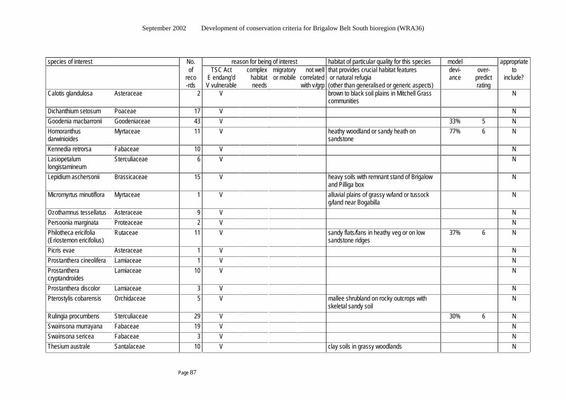
September 2002 Development of conservation criteria for Brigalow Belt South bioregion (WRA36)
Page 87
species of interest No. reason for being of interest habitat of particular quality for this species model appropriate of TSC Act complex migratory not well that provides crucial habitat features devi- over- to reco E endang'd habitat or mobile correlated or natural refugia ance predict include? -rds V vulnerable needs with v/grp (other than generalised or generic aspects) rating Calotis glandulosa Asteraceae 2 V brown to black soil plains in Mitchell Grass
communities N
Dichanthium setosum Poaceae 17 V N Goodenia macbarronii Goodeniaceae 43 V 33% 5 N Homoranthus darwinioides
Myrtaceae 11 V heathy woodland or sandy heath on sandstone
77% 6 N
Kennedia retrorsa Fabaceae 10 V N Lasiopetalum longistamineum
Sterculiaceae 6 V N
Lepidium aschersonii Brassicaceae 15 V heavy soils with remnant stand of Brigalow and Pilliga box
N
Micromyrtus minutiflora Myrtaceae 1 V alluvial plains of grassy w/land or tussock g/land near Bogabilla
N
Ozothamnus tessellatus Asteraceae 9 V N Persoonia marginata Proteaceae 2 V N Philotheca ericifolia (Eriostemon ericifolius)
Rutaceae 11 V sandy flats/fans in heathy veg or on low sandstone ridges
37% 6 N
Picris evae Asteraceae 1 V N Prostanthera cineolifera Lamiaceae 1 V N Prostanthera cryptandroides
Lamiaceae 10 V N
Prostanthera discolor Lamiaceae 3 V N Pterostylis cobarensis Orchidaceae 5 V mallee shrubland on rocky outcrops with
skeletal sandy soil N
Rulingia procumbens Sterculiaceae 29 V 30% 6 N Swainsona murrayana Fabaceae 19 V N Swainsona sericea Fabaceae 3 V N Thesium australe Santalaceae 10 V clay soils in grassy woodlands N
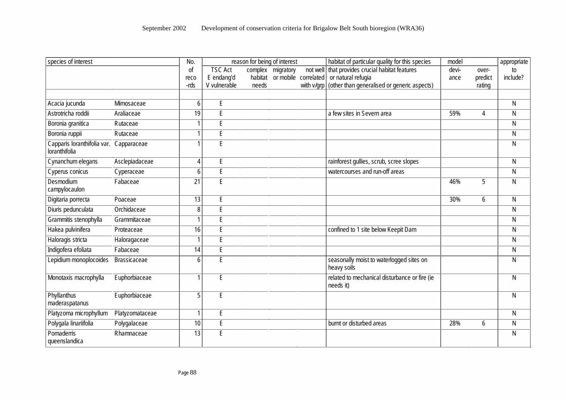
September 2002 Development of conservation criteria for Brigalow Belt South bioregion (WRA36)
Page 88
species of interest No. reason for being of interest habitat of particular quality for this species model appropriate of TSC Act complex migratory not well that provides crucial habitat features devi- over- to reco E endang'd habitat or mobile correlated or natural refugia ance predict include? -rds V vulnerable needs with v/grp (other than generalised or generic aspects) rating Acacia jucunda Mimosaceae 6 E N Astrotricha roddii Araliaceae 19 E a few sites in Severn area 59% 4 N Boronia granitica Rutaceae 1 E N Boronia ruppii Rutaceae 1 E N Capparis loranthifolia var. loranthifolia
Capparaceae 1 E N
Cynanchum elegans Asclepiadaceae 4 E rainforest gullies, scrub, scree slopes N Cyperus conicus Cyperaceae 6 E watercourses and run-off areas N Desmodium campylocaulon
Fabaceae 21 E 46% 5 N
Digitaria porrecta Poaceae 13 E 30% 6 N Diuris pedunculata Orchidaceae 8 E N Grammitis stenophylla Grammitaceae 1 E N Hakea pulvinifera Proteaceae 16 E confined to 1 site below Keepit Dam N Haloragis stricta Haloragaceae 1 E N Indigofera efoliata Fabaceae 14 E N Lepidium monoplocoides Brassicaceae 6 E seasonally moist to waterlogged sites on
heavy soils N
Monotaxis macrophylla Euphorbiaceae 1 E related to mechanical disturbance or fire (ie needs it)
N
Phyllanthus maderaspatanus
Euphorbiaceae 5 E N
Platyzoma microphyllum Platyzomataceae 1 E N Polygala linariifolia Polygalaceae 10 E burnt or disturbed areas 28% 6 N Pomaderris queenslandica
Rhamnaceae 13 E N
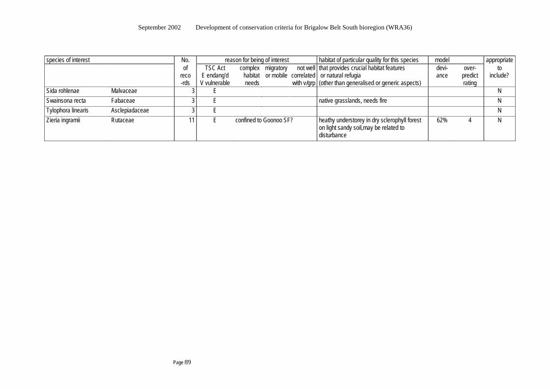
September 2002 Development of conservation criteria for Brigalow Belt South bioregion (WRA36)
Page 89
species of interest No. reason for being of interest habitat of particular quality for this species model appropriate of TSC Act complex migratory not well that provides crucial habitat features devi- over- to reco E endang'd habitat or mobile correlated or natural refugia ance predict include? -rds V vulnerable needs with v/grp (other than generalised or generic aspects) rating Sida rohlenae Malvaceae 3 E N Swainsona recta Fabaceae 3 E native grasslands, needs fire N Tylophora linearis Asclepiadaceae 3 E N Zieria ingramii Rutaceae 11 E confined to Goonoo SF? heathy understorey in dry sclerophyll forest
on light sandy soil,may be related to disturbance
62% 4 N

September 2002 Development of conservation criteria for Brigalow Belt South bioregion (WRA36)
Page 90
This blank page has been inserted here so the next section
appears on the right hand side in double-sided printing.

September 2002 Development of conservation criteria for Brigalow Belt South bioregion (WRA36)
Page 91
Appendix 7.1 A discussion of “active adaptive management”
Walker (1998) proposes that wildlife managers fall into 4 kinds according to their learning habits:
- catatonic (never learn),
- reactive (respond to crises as they arise),
- passive adaptive (monitor whatever action is taken, and refine management as appropriate in response),
- active adaptive (deliberately experiment with management actions to improve predictive capability with regards system responses to management).
He proposes that, clearly, active adaptive is the most effective form of management, and wildlife management and research should not be seen a separate. Experimentation should be done at management scale. He presents the following discussion of the need to combine active adaptive management with knowledge about ecosystem processes.
The focus in ecosystem management is on process, as opposed to trying to manage species or communities directly. The key to managing wildlife is habitat maintenance, which means maintaining the ecosystem processes that determine them. For the most part, in terrestrial ecosystems, this comes down to managing disturbance regimes and managing the nutrient and water dynamics in the system, keeping the variation in these dynamics within some limits. Hence, ecosystem management essentially means maintaining disturbance regimes and maintaining or restoring the spatial dynamics of water and nutrients. Scientists define stability as the persistence of all species in the system. Managers mostly interpret stability as meaning constancy in the abundance of species, however in order for all species to persist over time, variation in abundance over time is often necessary. A classic example is the now-recognised need for periodic fires in Yellowstone National Park – earlier efforts to prevent change and maintain the status quo led to unwanted changes in species. The first need is to understand and maintain the spatial dynamics of water. This is coupled with nutrient dynamics. The second and crucial aspect is that event-driven ecosystems need to be event-managed. Teasing out and understanding the disturbance regime is the key to understanding and identifying the critical points of intervention for management. For example, the species composition of Mitchell grasslands in Qld remains relatively constant despite grazing differences. New cohorts of Mitchell grass species occurred only under particular conditions (a good rainy season with late autumn rains following a year with a mid-summer drought. Management in the year of establishment is critically important because it influences the establishment of the new cohort. Attiwill (1994B) also urges active management based on an understanding of the ecological processes, and providing heathlands as an example. Keeping fire out of coastal heath results in its replacement by taller shrubs, which is not reversed by subsequent fire. In the absence of disturbance, heath lands become senescent (low to zero productivity) and the diversity of plant species decreases. Mammals of the coastal heath lands are also fire-adapted, and species richness is greatest early after disturbance, which is common to other Mediterranean-type ecosystems. In this case, the most appropriate form of management might then be to maintain a mosaic of ages of heath land to accommodate the range of responses of the mammal population to disturbance and thereby to maintain mammal diversity.
Australian Committee for IUCN (1996) urges that conservation policy should be determined by an understanding of its natural significance and should state the desired future condition of the place. The conservation policy should include consideration of ecological processes that extend beyond the stated boundaries of a place, with the aim of conservation being to retain the natural and cultural significance of the place.

September 2002 Development of conservation criteria for Brigalow Belt South bioregion (WRA36)
Page 92
Lindenmayer et al (2000) argue that the presence of a species within a biodiversity priority area should not imply lack of need for effective management regimes inside that area, such as the restoration of burning regimes that may be required by taxa dependant on particular seral stages or vegetation mosaics. They also argue that the identification of biodiversity priority areas does not mean that off-reserve management is not needed, because reserves will never sample all biodiversity, may not provide sufficient suitable habitat for some taxa, and may not be large enough to sustain some species they do contain without sympathetic management of surrounding areas. They conclude that an adaptive management approach integrating research, monitoring and management should be adopted to test the validity of principles such as stand complexity, connectivity, and heterogeneity as structure-based indices of biological diversity. The best approach is, for example, to treat logging as an experiment and implement monitoring systems and feedback mechanisms to management. This would provide new knowledge to managers and improve the effectiveness of management strategies.
Jurskis (2000) drives this further, proposing active management such as regular burning or thinning may be more precautionary than passive management in situations where non-intervention is likely to perpetuate or reinforce the changes that have occurred in the Australian landscape since European settlement. The school of thought that advocates minimum human disturbance of native vegetation and detailed research on the responses of individual species and functional groups, fails to acknowledge that profound changes may be occurring as a result of deliberate non-intervention. Since settlement, it is suggested that active intervention may often be more conservative in terms of the pre-European environment.
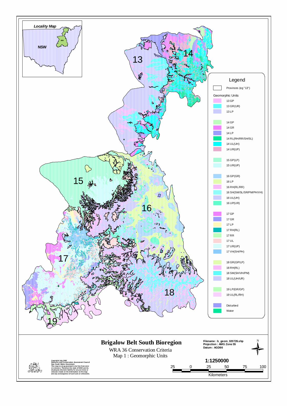
1314
15
16
17
18
19
Brigalow Belt South BioregionWRA 36 Conservation Criteria
Map 1 : Geomorphic Units
N
1:1250000Copyright July 2002Resource and Conservation Assessment CouncilNew South Wales GovenmentThis map is not guaranteed to be free from erroror omission. Therefore the state of NSW and itsemployees disclaim liability for any act done oromission made on the information on the map and any consequence of such acts or omissions.
Filename : b_geom_020726.shpProjection : AMG Zone 55Datum : AGD66
Locality Map
NSW
BBS
25 0 25 50 75 100
Kilometers
Provinces (eg "13")
Geomorphic Units13 GP
13 GR(UR)
13 LP
14 GP
14 GR
14 LP
14 RL(RH/RR/SH/SL)
14 UL(UH)
14 UR(UP)
15 GP(LP)
15 UR(UP)
16 GP(GR)
16 LP
16 RH(RL/RR)
16 SH(SM/SL/SR/PM/PH/VH)
16 UL(UH)
16 UP(UR)
17 GP
17 GR
17 LP
17 RH(RL)
17 RR
17 UL
17 UR(UP)
17 VH(SH/PH)
18 GR(GP/LP)
18 RH(RL)
18 SM(SH/VH/PM)
18 UL(UH/UR)
19 LP(GR/GP)
19 UL(RL/RH)
Disturbed
Water
Legend

September 2002 Development of conservation criteria for Brigalow Belt South bioregion (WRA36)
Page 94
This blank page has been inserted here so the next section
appears on the right hand side in double-sided printing.


September 2002 Development of conservation criteria for Brigalow Belt South bioregion (WRA36)
Page 96
This blank page has been inserted here so the next section
appears on the right hand side in double-sided printing.
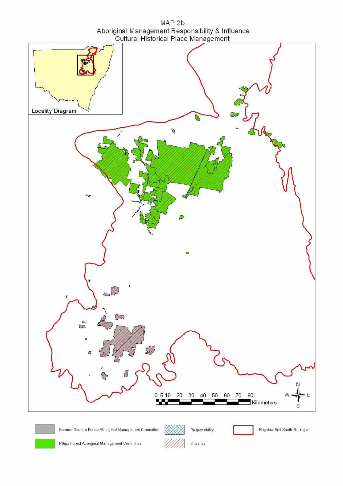

September 2002 Development of conservation criteria for Brigalow Belt South bioregion (WRA36)
Page 98
This blank page has been inserted here so the next section
appears on the right hand side in double-sided printing.
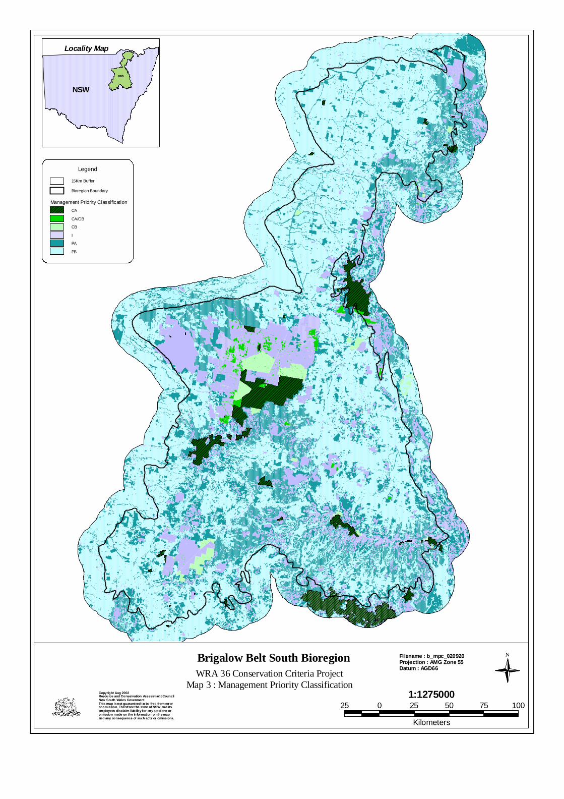
Brigalow Belt South BioregionWRA 36 Conservation Criteria Project
Map 3 : Management Priority Classification
N
1:1275000Copyright Aug 2002Resource and Conservation Assessment CouncilNew South Wales GovenmentThis map is not guaranteed to be free from erroror omission. Therefore the state of NSW and itsemployees disclaim liability for any act done oromission made on the information on the map and any consequence of such acts or omissions.
Filename : b_mpc_020920Projection : AMG Zone 55Datum : AGD66
Locality Map
NSW
BBS
25 0 25 50 75 100
Kilometers
15Km Buffer
Bioregion Boundary
Management Priority ClassificationCA
CA/CB
CB
I
PA
PB
Legend

September 2002 Development of conservation criteria for Brigalow Belt South bioregion (WRA36)
Page 100
This blank page has been inserted here so the next section
appears on the right hand side in double-sided printing.
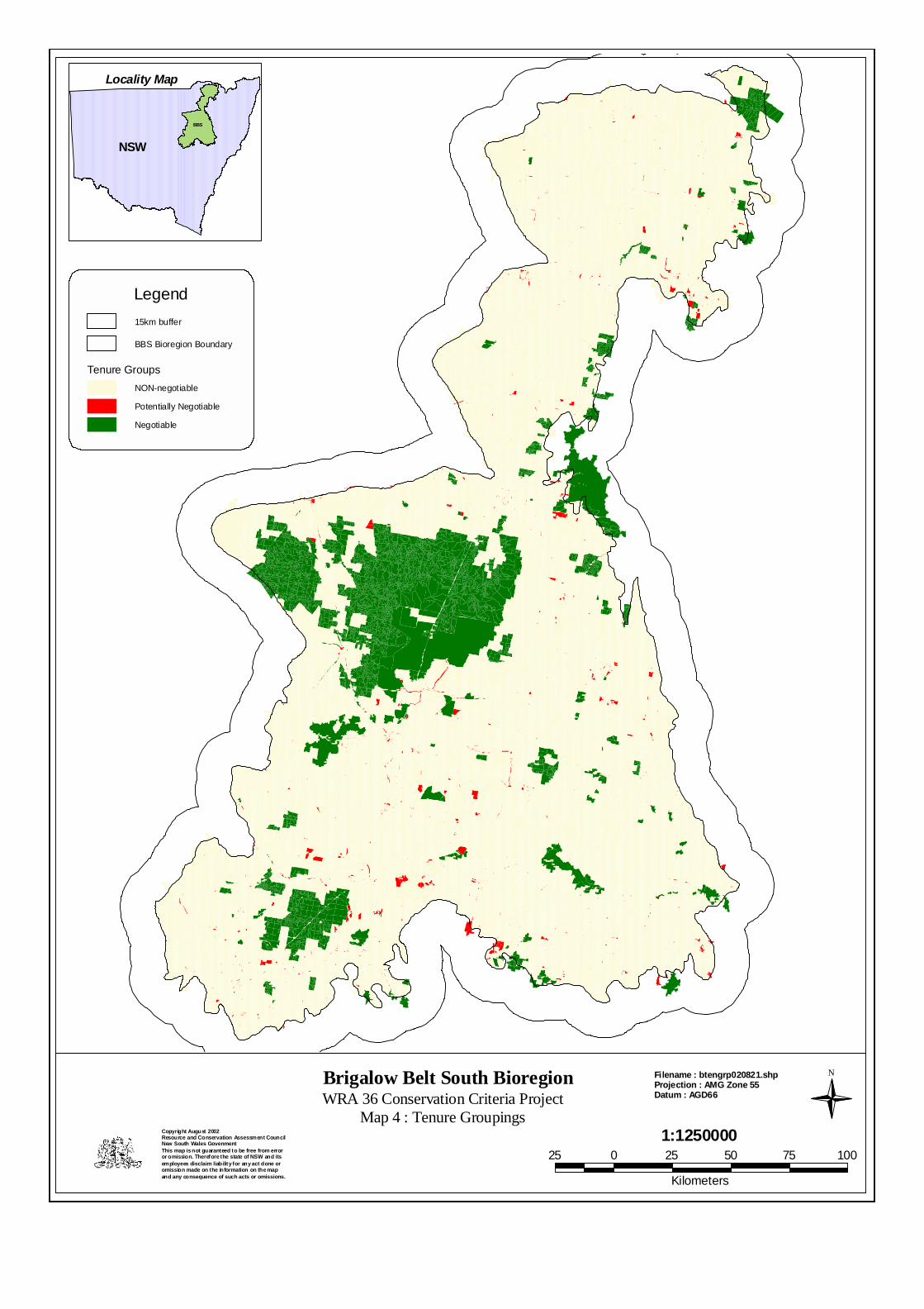
Brigalow Belt South BioregionWRA 36 Conservation Criteria Project
Map 4 : Tenure Groupings
N
1:1250000Copyright August 2002Resource and Conservation Assessment CouncilNew South Wales GovenmentThis map is not guaranteed to be free from erroror omission. Therefore the state of NSW and itsemployees disclaim liability for any act done oromission made on the information on the map and any consequence of such acts or omissions.
Filename : btengrp020821.shpProjection : AMG Zone 55Datum : AGD66
Locality Map
NSW
BBS
25 0 25 50 75 100
Kilometers
15km buffer
BBS Bioregion Boundary
Tenure GroupsNON-negotiable
Potentially Negotiable
Negotiable
Legend