Embed Size (px)
Citation preview
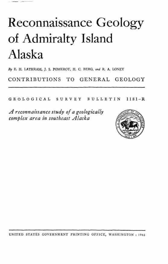
Reconnaissance Geology of Admiralty Island Alaska By E. H. LATHRAM, J. S. POMEROY, H. C. BERG, md R. A. UINEY
C O N T R I B U T I O N S T O G E N E R A L GEOLOGY
G E O L O G I C A L S U R V E Y B U L L E T I N 1181-R
A reco~lzaissaace study of a geologically comfilex area irz southeast AIasklz
UNITED STATES GOVERNMENT PRINTING OFPICE, WASHINGTON : 1 9 6 5
UNITED STATES DEPARTMENT OF TRE INTERIOR
STEWART L. UDALL, &?wefury
GEOLOGICAL SURVEY
Thomas B. Nolan, Director
Fur sale by the SuperInttadent d Doeumrnta. If.S. Gmcrnment Rtntinp Om- Wauhlngrrm, D.C., 20402
C O N T E N T S
~babact,--------------------------------------------------------- Introduction-,,,,,,,,-----------------------------------------------
Geographp,,-,,,,,,,,--,----------,,.-,----,-,,,---------------. Previous inv~ti@tions,,,,-,,_--------------,------------~------- Present investigations,, , , , ,-__ -- - - -- , -,, , , , , - -- - , ,- - -- - , - - , - -- -- , -
Teetonic nspects of the geology ,,,,--,,--,,,,-----------------------,,- Stratipuphy -,,,-, -, -, , , , --, , ,, , ------, ,,-- --- - - , ,, , , ,, -, ,-,,- ,, ,, , ,
S~luri~n(?) ro~ks,-,------,---,-----------------,-,-----,----~-- Devouinn and Devonian(?) rocksks, ----_-,_,---,+-d,------------
Retreat Group and Gambier Bay Formation - - , ,, - ,, - ,--,-* - -- Itood Bay Formation -,,,,, , - -- ,_ - ---- ,- ,-- - ,- - - ,- --- - --- ----
Perminn mcks,---,--,---,,,--.--,-*---------+---,---,-,------- Caencry Formation--- - - -, , - - ,- - - - ,-- - -- - ---- --- - - - - - -- --- - -- Pybus Dolomite,-,-------,,,,,-----,,--,,--,,,----.-*----
Undifferpntizted Permian and Trinsafc rocks ,,--,,--,,,,, ,--------
Triassic rocks ,,,,,--,-------d---,----,-,+---+---------,--,--,- Byd Formation,----------------,-,-,-,,-------------,,,,---,
Jurassic and Cretaceous rocks ------ ,- -,,,,,,--------------------- Stephens Passam Group --,----,-,,,,,,,------------ - -------- S~ymour Caosl Formation --,,-,-,-,-d,,-----------,-------, Douglas Island Velcanics --,,,---,--,,,-,,,,---,--,,---,-,,, Rrotheers Volcanica --,, -, , - - ------ - -, , , --, , , , , , , -, ,, ---,-- , ,
Tcdinrgroch----,---, , ,- ,---------------,-------------------- Kootznahm Formntion ,,,, ,- -,- -- - --- - - - - - - , - - - , - - - - -- - -+ - - Admiralty Island Volcnnics ,,,-,---,--,-,-,,--~-,-----------
Quaternary sedirnwtary deposits -,-,------------+--- - -, - -------- Undifferentiated metamorphic rocks , - - - - - - - - - - - ,+-- - - - - - - - - - - - - - -
Migmatile, meiss, and feldspntl~ic ~chi&- - - ---- ---, ----,,,,-,----
Mutar~icmcka,,------+---+---,--~--,+------,-----, , ,- ,------+- Felgic pll~tonic rocks ----------,,,-------------------,-,,--- Intermetlintc plutonic mcka -,,,.,,+,---,---------+~------,*-
hrafic and uItramn6c plutonic rocb ,,,---------,,---,,--,---. Btrt~ctural gcolom-, - - , - , . - - - - - - - - - - - - - - - - - - , - - - - - - - - - - - - - - - , - - - - - .
AdmimIty an ticlinorium --------,---*- - --- - -- - - -- ---- ---- -- --- - - .lunertu synclinorlum ,-----,------- --- - --- ---,----+------------,
Tertiary bssins --- , ---- . -------------------------+-------------
Fsl~lta-------,-----,-.-,-----------,--, , ,-, , , ,------,,--,--, , . Am of Folding, faulting, m d plattonism --------,,,,-,--,,------,---,,- Glnoiation and changes in sea Iced- - _ ----,-,--.--,,,----+-,--------.
Ecanomic~c?ol~y--------- , , , - , - ------------ , - , - - , - , , - , - -------- , - Selected references -,------------------------------------,----------
m
ILLUSTRATIONS
Y L A ~ 1. Geologic mpa of Admiralty Taland md Kootmahoo Met a m , Ahtaka.
2 Map and chart of mineral and foeail accurrcnem on Admiralty Island, Alaska. Pmm
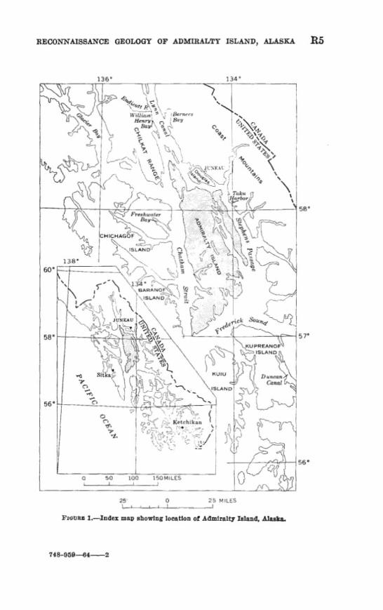
Fxamt~ 1. Tndcx map ellowing beation of Admiralty Idand, Alaska,, ,,, R5 2. Distribution of formatione of the Stephens Pausage Group-, ,, 22
Pene TAB^ 1, Bnmmsrg of stratigraphic unite on Admiralty Island, - - , ,-, -- R9
2. Results d X-sag spectm~opie examination of sulfida, odd%, md rare esrth mineral-bearing parnpIm ....................... 44
CONTRlBUTIONS TO GENERAL GEOLOGY
RECONNAISSANCE GEOLOGY OF ADMIRALTY TSLAND, ALASKA
ABSTRACT
AdmPralb Xslaad, one of the major ialnnda of the Alexnnder Archipelngo, 11- adjacent to the Maskan malnland sontb of Snnenu. BilutIan ( 7) to Q u ~ t e ~ f t ~ sedimentary, metmnorpbic a d Igneous rwks crop out In the largely unluhnbika, moderfltely rugged nrw.
The Ingered rocks of Admiralty I~Iand comprlse six depaelttonal Beqnenceer, five of marine (eugeospnclin~lf and one of nonrnnrine origin, ench septtrnted by nnconformities, Grnywacke, slate, and IIrnestone of Silurtan { ?) aR@ are the oldest sequence. Schist and marble, representing metnmorphmed ~snywacke, ailteone, limestone, and ~olcanjc rcka . form the Retreat Oroup and the Ofirnbi~r Bay Formation, These mckn together wlth the apparently coeval unmetnmor- ph& blnck arglllite and chert o l the nood Bay Formution, make up thc next younger wquence (Devonian and Dmonian ( ?) 1 , wblcb 18 of unknom t h l c k n r ~ . The Cannery Formallon, conrrlding. of more than 2,tMU feet of graywacke, agrll- Ute, chert, and conglomerate, and the overIylng Pybus Dolomite, na much aa 1.000 f& thick, f o m the nest younger Bequencr! (Permian). The Hyd Formatlon (Riaasie), composed of thin-bedded impure Ilrnestone, blnck chert, nnd black
alate interhering with and overlain by basalt end andmite plllow flows. forma the fourth aeqnenee. The fifth Heqaence, the Stcphcna Fnssst~e Group (Jurnssic and Cretnceoua) is more than 5 ,Oo Sect thick; it curnprtsea the Seymorrr Canal Formation, composed of date, gmgwncke, ant1 conglomcrnte, the Dou~laa Island Polcanics, which includes augiteh~nring andealtic and b~mnFtlc ffom breccia, and the Brothers Volcanlcs flow brmla. The iorrnatlona of the dlfth wuence nm eqniv~tent in age nnd htcrtongne along Seymour Canal ~ n d Stephens P a a g e . The youngest pequence ia nonmarlne. late Paleocene through 311occne la age, and includes the Rootznnhoo Fermntion, cornpnficd o f a h a t 6,000 feet of con- glomeratcn sandstone, siltstone, shal~ , und cnnl, and the overlslns Admid@ Island Yolcanics, which conaista of hnsnltrc nticle6itc flows more thnn 10,000 feet thlck.
A major o m n r , mat-earlfest Early Cret~ccons to gr~Palmcene In age, prob- ably cuImlzlated b middle-Cretnceous tlnie and formed the major structural fea- tures of the Island. These nrc t h ~ Admlrnlty antidlnnrlam, wblch form@ the central and weslrrn part of the Island and ia a part of the Prince of Wale8 geanticline, and the adjoinlng Jnnenu syncIinorlum to the enat. Folding of at leaat two stages reeultd in supergasltfnn of the folds, Moat of the folds rim orertnmed-those in the antlcIinorium largely to tho northeast and tboae in the
R l
R.2 CONTRIBUTIONS TO GENERAL GEOLOGY
synclinorium to the southwest. Earlier deformation may be the reason for dif- ferences in folding and metamorphic grade observed in the older depositional sequences, but lack of critical exposures has prevented recognition of earlier orogeny. The emplacement of felsic to ultramafic plutonic rocks may have been largely posttectonic, although one pluton, that a t Point Retreat, is clearly pre- or syntectonic. Large bodies of contact-metamorphic rocks and migmatite border some of the plutonic masses. Low-grade regional metamorphism accom- panied the orogeny and affected most of the island, particularly the central and western parts. Faulting along northwest trends, with both vertical and hori- zontal movement, accompanied and followed the folding. The Tertiary sedi- mentary rocks were deposited in two unconnected intermontane basins. Al- though there is no evidence of post-Miocene folding or plutonism, post-Miocene faulting, largely with vertical movement, occurred along north and northeast trends.
The area was glaciated to a n elevation of about 3,000 feet during Pleistocene time. No glaciers remain a t present. Fossiliferous marine beaches a t eleva- tions of 475 feet attest to a higher sea level or a lower elevation of the land surface during Pleistocene time.
Metamorphic rocks west of Hasselborg Lake and around Slide Lake contain local concentrations of sulfide and oxide minerals. Aside from intermittent exploration a t the Funter Bay nickel-copper deposit, there is currently (1963) little mining activity on the island, although some of the now inactive mines have produced modest amounts of gold and silver.
INTRODUCTION
GEOGRAPHY
Admiralty Island, one of the major islands of the Alexander Archi- pelago of southeastern Alaska, lies between lat. 57" N. and 58"25' N. and long. 133'50' W. and 135" W. (fig. 1). It trends in a northerly direction, is approximately 96 miles in length, and ranges in width from less than a mile to 30 miles. The northern shore, along Stephens Passage, is 10 miles south of Juneau, the State capital. The island is bounded by Stephens Passage, Frederick Sound, Chatliam Strait, and Lynn Canal, all inland waterways. Admiralty Island is shown on parts of three 1: 250,000-scale U.S. Geological Survey reconnais- sance topographic maps-the Sitka, Juneau, and Sumdum quadrangles.
The population is small, and the few settlements are located on the west coast. The only permanent village is Angoon with a population of about 300. Seasonal settlements are located adjacent to the can- neries at Hood Bay and Hawk Inlet. As a rule the canneries are closed during the winter. The villages of Funter, Killisnoo, Neltushkin, and Tyee have been abandoned.
Admiralty Island is accessible only by airplane or boat. Alaska Coastal-Ellis Airline flights from Juneau or Sitka make daily stops at Hood Bay, Angoon, and Hawk Inlet during the summer. Charter service is needed for other areas. Most of the inlets and bays provide good anchorages for boats; however, utmost care is needed when
entering or leaving Rootznahoo InIet. Strong tidal currents make entry feasible only at slack water.
The interior of Admin~lty Island js accessible by a network of good to fair trails which connect many l a b . Also, a trail ncross Mans- field Peninsula connects Funter Rny with the mouth of Bear Creek, nnd a road about 3 miles Zon,a joins Angoon wit11 the point opposita Rillimoo. Shelters a m at some of the large lakes in the cantnl part: of tho island, and s lodge is at tha weat end of Tllayer L~lie. The shdters at Camp Shaheen on the aaststarn shore of Hamlborg Lake are rnaintrtined bp the Forest Service.
Modemtely rugged relief is chrtracteristic of most of Admiralty Gland. Elevations axe generally less than 4,000 feet, although meas of greater elevnt,ion occur in the ridge systcm a few milts northweat of Hasselbrg Lnke, rtnd also in the Eagle Peak area south of Point Young. Randolph Peak on G l w Peninsula also exceeds 4,000 feet. The highest point on Aclmimlty Island is an unnamed peak slightly more than 4,800 fwt high which is roughly 5 airline miles m&north- west of the northern end of Hasselborg Lake. Summits and slopes below 3,000 to 3,300 feet are rounded and smooth; those above m Bxtmmely jagged and precipitous. In the southern part of the island the Tower elevations consist of platems having gentlo sJopm. &la- t i d y low nms are northern MansfieEd Peninsula, tho northern half of Glnss Peninsula, and a northeast-trending belt that includes Kootmnhoo Inlet and Mole Harbor.
Physiographic features are commonly oriented in a n~rthwest~ward diwction throughout southe&m Alaska and reflect. the dominant strike of the folintion or bedding in the rocks. This orienbtion is conspicuuus on northern Admiralty Island, in the Seymour Cnnd a m , and in park of Pyhs and Gambisr B ~ y s . RIsny of the physi* graphic feautres of southern and central Adrnimlty Island, homcv.vlcr, trend nortl~east ward. The belt that includes Km tznaI~oo Inlet nnd Mole Harbor, the valley between Hood and Garnhier Bays, m d the sontheastern coastline Rre nI1 examples.
Admiralty Island has the mild winters, cool summers, and plentiful precipitation characteristic of most of southeastern A l ~ k i h June is usually the driest month. Precipitation increases progressively each month thereafter and renclms n penk in October. SnowfdT is rela- tively light at or near sea level. Weather records are available only for the soutl~western and extreme northern parts of the island. For the 29 yenrs prior to 1023 the TVcnther Bureau m r d s indicnte that the annual precipitation in the KiIIisnoo-~ZRpon area avernged about 63 inches (nuddingkon and Chapin, 1929, p, IS). Evidently no record was kept at Point Retreat during that perid. A series of recent
dim~atio maps (Weather Bnmu, 1959) for the period 1031 to 1955 indicate that the m u a l rainfall for Angoon and Point Retreat is 80 inches. 'I'hc~ isolines reveal that hmvier precipitation, as much a% 100 inches, is characteristic of most of the island.
According to the climatic maps, the mem minimum and mnximum temperatures (Admiralty Island) for Jrtnunry are 24' and 32"-34" F. bfem minimum and maximum t~mperaturez for July are 48"-50" and 60°-6P0 F.
General15 optimum conditions for fieldwork exist from the mid& of May to the first of July. During this interval the number of clear to cloudy days exceeds the number of rainy days; however, tllare is mow cover on the higher elevations, h hoavy enrly-spring snowfall will obsrmre outcrops at elevations as low as 2,000 feet until June. By midsummer the rmow is gons from most of the r i d p , but frequent low clouds, fog, and rain hamper field work.
In the summer of 1959, more rain fell in the month of July than in the month of August, a departure from the usual rainfall pattern. The following table indicates the weather conditions observed by the field party for the period Blsy 22 to August 27, 1959.
Veptation is luxuriant up to the timberline, which is germally at about 2,500 feet, In the low-lying areas, thick undergrowth in the form of devilsclub, alder, and various types of berry bushes make trnvel slow. Hemlock and spruce am the most abundant coniferous trws and form den- ~tnnds. Vegetation above the timbnrline is sparse and consists of lichens and heather. The entire island is part of Tones8 National Porest.
The earliest geologic investigation of Admiralty Island (fig. 1) wss m d e in 1895 by DaIl (1696, p. '7'16-783) in the Kootznahcw, Inlet area. Prior to this time both the U.S. Navg Department and private prospeetors had looked for cod in the Bootmshoo Inlet area and nmr hlurrler Cove.
Wright (1906, pl. 333 made the &t geoIogic reconnaissance map of Admiralty Island. This map was based primarily an shoreline studiea
R6 CONTR~TPTION~ M GENERAL GEOLOGY
made in 1904 and on GEs to some of the prospects existing at h t time. Kirk (1918, nnpnblished data) made further observations as part of a reeonnnissance study of Admiralty and Chichagof Islands, but his report was never completed. Kindle (1907) and Martin (1926) co1lected fossiIs from Pybus I3ay and nearby areas.
A great deal of prospecting took glace around 1900, and v a r h s prospects and smnll areas have bmn examined by geologists since that time. The northern part of Admiralty Ialand, particularly the areat around Punter Bay and Hawk Inlet, has m i v e d the most attention. Nickel-copper-gold deposits w r a examined and described by Wright (ISl)ti, p. 247-150), Ealcin (1918, p. 84-92), Medie (1921, p. 113-1181, Budclington (1026, p. 42-50), and Reed (1942). Burchard (1920, p. 48-56), surveying the marble resources of southea~tern Alaska, exam- ined the marble outcrops along the western and southwestern shore- lines. An asbestos prospect east of Funter Bay was examined in 1928 and 1944 (Twenhofel, Reed, and Gates, 1949, p. 34-37). In 1049 reconnnissnnce radioactivity studies were conducted in the Funtm Bay area (Wat and Benson, 1955, p. 51-52).
A. F. Buddington and Theodoro Chapin (19293, in their recon- naissance study of the gedogy of sontl~eastern Alaska, modified Wright's early mep of tho i s l ~ n d and correlated the p l o g y of the island with thst of the rest of m~rthertsstern hlsla. Observatiom on tho p I o g y of the southern end of Hssselborg Lake were made by R E. Fellows in 1947 (unpublisl~ed data). C. L Sainsbury made nurnemm observations in Funter Thy and ne,zrhy ~rtreas (1953, unpublished data). &st recently, Fml Rtlrker ( 1957) mapped tl10 p10gy of the Juneau ( R 4 ) quadrmgla, which include^ the northermost part of Mansfield Penhsulrt.
Systematic geologic m~pping of southenstern Aifnska at a scale of 1 : 250,000 was I x p in 1956, as a part of tho Iong-mnge minerah p m gram of the Geological Survey. The p u r p ~ ~ e of this mapping is the prepamtion of regional geologic report,? suc11 as the present report, which may kw used to pic la tho search for mineral rawurces.
'She field data upon which this report is based were derived chiefly from exposum along bench& and streams, and in the high country above timberline. Field observations elsewhem, worn very sparse. Small Goats mere used in mapping the baachos, and a helicopter WM
nsed in mapping the interior of the island. Mapping in the field was done on U.S. GeoIogical Survey topographic quadrangle maps at 1 : 63460 scale, Geologists worked individually for the most part, and mmmunicatd by means of walkie-talkie mdios. Base camp was main-
RECQNNAISSmCE QEOLQQT OF ADMIRALTY ISLAND, ALASKA R7
tained on the Geologicill Sumy motor vessel S t e p h R. Cappa, an 88-foot self-propelled barge with a heIiport on the bow. IR. D. Stacey, Masterq nnd ,John Muttart, cook-seaman, operated the vesseI.
The reconnai.ssnnce mapping of Admiralty Island was done under the general supervision ef E. H. Lnthmm During the period of his absence from the field in 1059, fieldwork was directed by R A. Loney. The mapping tr~s accomplisl~ed large1 y dnring June and July of 1957 and the summer of 1059. In 1957 the field ga3.t~ consisted of Zathram, Loney, 'lT. W. Condon, IT. C. Berg, md Maurice Grolier. A prelimi- R ~ V interpmtation of the geologp north of Iat. 58" mas subsequently publishwl (Lathnm and others, 1958,1059). Lthmm, accompanied by Condon, mnde a preliminxry survey of the wuthern and central parts of the island in late 1958. In 1039 the field party consisted of Lathram, h e y , Berg, J. S. Pornerop, and D. W. Hincldey. Douglas Barnes assist& the plogis!s during the srunmer of 1959.
R. A. Tmney studied the Strat ippl~y and structl~m of the -bus- Gmbier area in detail in 1058 and 1959. This work (Lone?, 1964) greatly facilitated the reconnnismnse mapping. In the course of the m~pping, :,sttereci small areas wem studied in
detail in order to define mnppnhle units. whose contacts were then ex- tended lxtemlly by peconnilissance methods, including spot checks and aerial photograph interpretntinn. Recause of stru.lrehral complex- ity and metamorpl~ism, as well RS veptntion md rmconsolidnted cover, p l m e n t of contacts on the geelogic map ( pl .I) at some places ma9 quih arbitrary; the units mapped may include smnll s m s of other map units either unrecognized or too small to rep=nt nt the scnle of this map.
Thin sections were studied to dkwify moat of tho rocks ; ltnless other- wise noted, rock hrminology throughout the rep& follows that used by Williams, Turner, and Gilbert (1054).
TECTONIC ASPECTB OF TIHE UEOLOQY
Admiralty Island lies wholly within n mobile belt that borders the Pacific Ocean and has been the site of rnarino geasynclind deposition and intermittent deformation t11ronghout most of the Paleozoic and Mesozoic Eras The deposits belong to the typicnl eugeosgnclinal suite of Pettijohn (195'7, p. 640) and other writcm; that is, these de- posits are gmdominantly siltstone, grayvacke, kmdded chert, lime- stme, and abundant volcanic rocks.
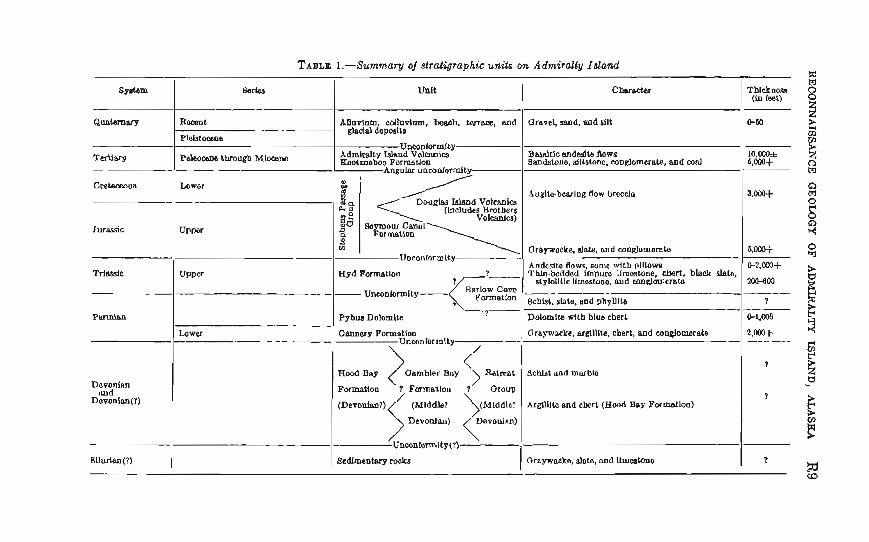
The consolidnted mIcs rango in age from Silurian ( f ) tn M i m e (tabla 1). Six depositionnl sequenccn are recognized, which reflect five episodes of marine e u g ~ s ~ c l i n a l sedimentation and one episode of terrestrial deposition, Graywacke, slate, find limestone of Silu-
R8 (?ONTRIBUTIONS TO GENERAL GEOLOGY
rim( 9 ) form ths oldest sequence. The second sequence consists of m~hmorphic rocks, mapped a9 the Retreat Group and Gatnbier Bay Formation, of Devonian age. Black argillite and c h e ~ of the Hcmd Bay Formation, probably of comparable age and deposikd in a reducing enviroment, may m p m t mval deposition in a different part of the geqncline and a faciw of the second quence. This m n d sequence forms the major part of the island. The third quenae, of Permian crops out on the eastern and southern s l o p - md shores of the island, and m r d 8 deposition in a rapidly sinking trough during Early Pemian time (Cannery Form&tion), followed by less active subsidence and shallower wxa (Pybus Dolomite). Vol- canism waa minor. The Upper Triamio Hyd Formation forms the faurth quenca, whm wide distribution of thin-bedded b h k shale, chart,, and fmpure limestone indiaaka depmition in a broad, slowly subsiding wamy in which reducing mndi tions were widlespred. Ex- tensive volcanism closed Triassic deposition. Th8 fifth sequence is I;ah Junassic md Early C r e w u s in age; it onm more m r d a depDsition in a rapidly subsiding eqpqmcline. !l%is sequmm, the Shphms Paasage Group, consists of slab graywacke, and conglom- emte (Seymour Canal Formation), and augite-bring andesite and bsbsalt Aow b m i a (Douglas hlmd VoIc&nics and Brothem Valean- ics). The last sequence, which is Tertiary in age, is entirely non- marine. Qalaocene through M i m a deposition occurred in discon- n b d internontam basins, largely as alluvial fans, piedmont and swamp deposits (Kootznahoo Formation), and IW extensive fissure eruptions of I a n (Admiralty Island V01canics). The flows appar- ently o v d e the boundaries of some of the basins, but wera not o9trudod in othem.
These sequences are separated by unconfodties, only one of which is unquestionably angular. The period of uplift and erosion which separated Jurassic and C r e w u s from Tertiary deposition wm attended by nt least two stages of folding, one superimposed on the other, wmpanied and fallowed by ths empl~c~ment of plutonic r+ by regional metamorphism, and by major faulting resulting in faults striking northwestward. This orogsny probably reached its maximum in middle Cretaceous time. Faulting again ~ x u m d after the deposition of the Tertiav volcanic flows, this time resulting in faults striking northeastward and north.
The island was intensely glaciated during Pleistocene t h e , but elevations abwe 8,000 feet were mostly ice free. No glmiem exist at present. Ancient marine terrace deposits, some of which contain PleisMeng fossils, have hen found at elevations of as much aa 475 feet. Th- deposits indicate a higher sea level or lower elevation of the land surface, in Pleistocens time than now.
Tblckness (h k t )
0-50
l O . o ( M 4m+
3.mS
&W
@ ? . ~ S 20WO
9
bw4
2,m+
?
?
7
G&m
Quahaw
FerMarg
CwteceOua
~ ~ a r s i c
Masslc
P w m b
Dsvbnlan auld
Devonian(?)
BIlurtsn(?)
Barbs
Rocan t
PWstoclens
Paleowe through Miocene
Lowar
w p m
upper
Lower
UnIt
AUofinm, wUuvlnm. benab, tenace, and Wal deposlta
UnmnloT+ty Admitalcy Wand V o l m w gwGmaboo Pormaalon
Angular unconlordty
D o u g h Wand Voicmles (Includes Bmtbers
V0lcania) 3% Baymour Csnol Formstion
LC
Voconlorrnlty
Hyd Formatloo I - P
Unconlormlly- Rnrlow Cdvo
Pybua Dolornib
Canaery Fcfmalion Uncanlorlnlty
Charsctar
arnvd, m d , and sllt
Bmnltlc andaslta Aows Sandsmm, dltstonc, mnglomer~le, and coal
.Suglte-bearlug flow broeclo
Ompwocke, dote, and o o ~ o m e r a b
Andcslto flows, some with plllaw~ l'hln.boddacl Imnw llmostone, chert, black &to,
6lqlollllc Ilmostono, and eon~omernto
8chht, s k h , 6.d phylllb
Dolomlta d t b blue cbert
Clrapaeke, nrgllllte. chart, nod wngiomarate
<' Formation 9 Fcemwlon
(Middint ArgUUte and cbert (Hood Bay Formnilon)
Uneonforn\l ty (?)
Bedimsntqy rocks Oraywacks, slato, and Ilm~tono
R10 tX)NTRIBUTIONB TO GENERAL QEQLOGTI
Rocks of probable Silurian age crop ouk only on the peninsula nnd islands east of Murder Cove (pl. 1). At this locality, schistose gray graywacke, dark-gray slate, chert, and minor paywacke conglomerata under1 ie durk-gray tliin-bedded limestone. The sequence is folded and the thickness is unknown. The Silurian( 1 ) mIrs are overlain by almost flat-lying Tertiary rocks to the north, but the contact is covered. Triassic rocks of the Hyd Formation bound the Silu- rian ( 8 ) rocks on the east, but the contad is mmmd and may be a fnu l t A fossil coll&tion, 50ABg4O (USGS Silurian-Devonian lac. 6384- SD) , made on Carroll Island (pl. 2) contains Tryphima, indicative of Xarly Devonian or more probably Silurian nge (IT. A. Oliver, Jr., U.S, Geological Survey, written commun., 1959). Silnrian rocks of comparable lithofo&g are reporkd in other parts of southeastern Alltslta (Duddington and Chapin, 1029), but detnfled correlation is not possible.
D E V O W A m smonudu( 7) ROCKS RIFFREAT QRODP AwD f 3 A B W m BAY FORMATION
Il&h%dh a d lithology.-From Pybus Day nortl~westward to Point Retreat (pl. I), scllisL and marhtc form the backbone and the westem side of the island. The hlt of outcrop is not continuous, but is interrupted by the batholith at Thayer Lake (pl. I), which divides the belt into a northern and a souther11 segment. In tho northern segment, the rocks am continuous with those of the Retreat Gmup, nnmed and nvrpped by Barker (1957) on Mnnsfield Peninsuln, and are wiped to that p u p . In the rsouthern sep~cnt, tho rocks are con- tinuous with those of the Gmbier Ray Formation, mapped by h n e y (1964) in tbe Gambier Bay area (pl. I ) , and &re assigned to that formation. The litfiology, stab of metamorphism, structum, and stratigraphic psition of the two units are the same, and they are con- sidered to be mmlztive and probably equivdent. Consequently, al- thouall the two unih are mapped separately, they are discu~ed together.
The most typical and most accessible exposures of the rocks of tho Retreat Group are along the shores of Hawk Inlet and t l ~ a western shore of the island from Point Retreat to near Narble Rluffs (PI. 1). The rocks of the Gmbier Bay Form ation are best seen dong the south shore of Gnmbior Bay,
Schist and Icsser phyl1ite predominate in the two units; the most common varieties of scl~ist am chlorite-albiteepidote schist, calc-sili-
cab =hi& sericite-chlorite-dbite schist, ,gaphitic quartz-muscovite schist, sericite schist, amphibole schist, and gamet-muscovite-qunrtz- feldspar schist. Grnphi tic schist i s commonly pyritif emus, and pyrite crystals an inch in maximum dimension may be found. Thick lenses of thin- to thick-bedded, dark-gay and light-gray to buff, fine- to medium-pined rnnrble nre common. Some outcrops of marbIe show thin dark-gray laminations ; others are mottled and contain irregular dolomitic arena. Thick, prominent exposures consisting mostly of marble and subordinnte intsrhedded scl~ist form the hipl~lnnd aress south and north of 110013 Rny nnd north of Gambier Bay, the wide belts st Marble Core, find along the bencl~ f ram Kootznahrw Inlet to Parker Point. These units ncc shorn sepnmtely on the geologic map (pl. 1). Qenemlly, the rnnrble in the higl~land areas north of Hood and Gambier Bays is mnssive, whereas that in the wide beIts along the west coast of the island is scliistosa. Smaller exposures of marble m u r along the north (Bnrker, 1957) nnd south shores of Fnnkr Bay, on nearby islands, on the bluff 1% miles southwest of the cannery at Hawk Inlet, on the coast 1 mile south of Cl111e Point, on the headland between the northwest and west a m s of Gambier Bay, and on Muse Island in Gambier Bay. Grnphitic and pyritic blaclt slate is common lwl ly on Mansfield Peninsul~ (Bnrker, 1957). Thin h d s of fine- grained greenish to white quartzite ~ r o common; them beds mray be metmorphosed chert. An o~ltcmp of serpentini~d doIomite 6.5 miles N. 63O E. of Point %&en probably represents the alteration of lime- stone by an dtraanafic intrusive body.
T h b h 8 a d sfmtigraphic relations.-The thickness of the Re- trent Group and the Gambier Bay Formntion is unknown. The hse of neither sequence has been recognized, and the rocks havo been folded seveml times, sheared, and rec~stsl l iaed. As a result, the conspic- uous compositions1 layering in the rmks is mrely the arginnl bedding. 'She most conspicuous surface is z folinkion that is oblique to the orig- inn1 bedding. TZle bedding is visible only as bande on the foliation. Marble beds are strongly folded and discontinuous. The thickness of this sequence is at lesst several thonsand feet, and may be many thousands of feet. Some of the rnnrble units nre as much as 1,000 feet thick; one north of Gsmbier Bny may be as much as 4,000 feet thick, hut repetition by folding may be responsible for this great tllickness.
Saveral maps of pnrts of Mansfield Peninsula. which show the dis- tribution of various lithologic types in the Retrent Gmup (Reed, 1342, fig, 1; Lathram nnd others, 1058, 1959) have been published. Tnas- much as the compositional layering commonly is not the original bedding, the distribution of these lithologic units is probMg not directly related to their stratimaphy. Accurdingly, no subdivision of the schist in this area is made in this report.
T h e stratigraphic position of the thick marble unit that is mapped qarateIy in ths Gambier Bay Formation is obscure, In genemI, exposums of the unit cap ridgea formed of *hist; I d l y , however, schist appears to overlie the marble, and the marble commonly con- tains scllist interbeds. Henca, it is not known whether this unit over- lies the schist sequence that forms the Retreat Group and the Gambier Bay Formation or whether the unit lies within the upper part of the BCh ist quenm.
The Cannery Formation, of Permian agei rastg dimtly on the Gam- bier Bay Formation in the hills west of Gambier Bay and overlies the Retmt Group near the headwaters of Wheeler, Pack, and Green Cmoks. On Mansfield Peninsnla, the Retreat Group is overlain by the Bar low Cave Formation of Permian and Triwic ( ? ) age, (considered by Ihrker, 1957, to be Jurrtssie ? to Early Cretaceous?). Barker p l d the contact between t h ~ Retreat Group and the Bnrlow Cove Forma- tion at ra prominent northwest-strikmg fault which bi- Barlow Cove at its head. After reexamining this locality, the authors feel thnt the rock9 immediately west of the f a d t at the head of the cove are more compamble lithalogically to t h w of the Barlow Cove For- mation east of the fault than to those which make up the bulk of the Retmt Group. Accorclfngly, in this report, the mntact is placed along the west shorn of tho cove. The nature of the contact is unmr- tain, and to tho south ohis contact is covered. Near the head of Wheeler Cmlq an outcrop of Upper Triassic limestone and chert is mmplehly surrounded by schist. of the Itetmt Group, but the contact is concealed. T e r t i a ~ rocks overlie tho Gnrnbier nay Formation with mgulnr m- conformity on the southwest side of Ranalku Bay.
The Gambier Ray Formation wns not seen in contact with the Hooa Bay Formation. The areas where the mntwt is drawn on the map am covered.
A major unmnformity mparates the Retreat Group and Gmbier Bay Formation from all younger rocks. Lower Permian rock am the oldest that overlie these two units. Upper Devonian and Mississippinn strata tlilst Wl approximately ll,OOO feet In th ichw on northexstam Chichagof Island (Loney and others, l963), as me11 as PennsyIvanian rocks, are missing on Admiralty Islmd.
Age and oo?.relalim.--On t.he basis of f d s of Devonian (probably Middle Devonian) a@ found in marble beds on and near the sauth shore of Gambier 13~y , Loney (l9M) assigned an age of Middle{ P ) Devonian to the Garnbjer Bay Formation. Additional collections made north of the bay substantin& this age assignment (PI. 2). As Ianey pointed out, however, rocks older than Devonian may be included in the sequsnca. Edwin Kirk (unpublished data) found corals he re-
f e d to as the genera Favosites m d CIadopora in the prominent marble bluff north of Village Point, a locnlity that wns not covered again in the present study. He believed that, althoug11 the fossils could be of either Middle or Lte Devonian age, the littiology of the marble and m i n t e d sedimentary rocks indicated a Wddle Devonian age assignment. No fossils have heen found in the Retreat Group, Barker (1957)
assigned the group an a@ of I ~ t e Triassic ( ? ) to Early Cretaceous( P because of its stratigraphic position below unfossiliderous rocks that he wrrelakd w i t h h o r n Cretamusmks of Yy'brts Bay. Because of comparable lithology, structure, stah of rnetsmorphism, and strati- graphic position, the Retrent Group is now cornlaad mith the Gambier Bay Formation and is aIso here considewd Middle( P) Devonian.
In age and lithologic t-ppe, the. rocks of the R e t m t G m p and the Gambier Bay Formation nm similnr to Silurian(?) to BtLidSle(?) Devonian dastic sequeilces on nortlleastern Chichagof Island (Lath- ram and others, 1950; Loney and others, 1963) and in the central and southern part of the Chi1 knt R n n p (Lathram and others, 1959). In the Glacier Bay area, Rossman (1963) has mapped the Tidal Forma- tion, which has a similnr lithology, and which he considers to lm of Late Silurian rsge, The marble sequences are similar to the ICmnel Creek- Limestone of Middle Devonian age in the Freshwater Bay area ILoney and others, 1963) and Middle Devonian limestones elsewhere in northeastern Chichngof Islrand, and the Chilkat Range (Lntbmm and others, 1959).
South of Admiralty Is1 and, Devonian rocks of comparable lithology am widesp~etld (Buddington and Chapin, 19291, but it is not possible to correlate with assurance any particular stratigraphic section with that of Admiralty Island.
HOOP BAY FORMATfQR
Betwwn the northwest arm of Pybus Bay and the head of the North Arm of Ilood Bay, rocks of probable Devonian age consis+, of a mo- notonous sucmion of black srgillite, thin-bedded Mack chert, m d minor thin interbeds of Mack, impure limestone. Tltis section was named the Hood Bay Formation by h n e y (1964). The thickness of the formation is unknown. Betmeen Hood and Whitewater Bays a group of similar-appearing racks is exposed on the beach under the Tertiary flows. Thesa rocks are also assigner1 to the Hood Bay I;brma- tion.
The formation is overlain with angular unconformity by volcanic flow of Tertiary Rge. Its relationship to other mapped unit,s is lesa clear. It is in eontact mith the Cmnery Forrnnt ion of Perminn age in
74IC95-
R14 CONTRIBUTIONS TO QEMERAL GEOLOGY
the Pybus Bay nrea, but the mntact is cove& in some plasas and in others is a f a111 t . The contnct betweon the lIood Bay Formation and the Garnbier Urty Formation is also mvered everywhere, Tha two formations ttro of quite difleront lithology, the Hood Bay Formation being relntively unmetrrrnorphosed, whereas the Qambier Bay For- mation has undergo~~e low-grade metamorphism. The arm of cover along their contact is too broad to determine whether the change in metamorphic grade is gradual or abrupt. Lnthram and others (1960) correlated the m k s of the H o d B R ~ Formation with t h m of h o r n Permian or Triassic age in the Pybus area. However, Loney (1964), on the bwis of fossil evidence, showed that these rocks are probably Devonian and suggested that they are m r r e l n t i ~ ~ with those of the Cfambier Bay Formation and that, the two formrttjons may intertongue, Thick sections of m k s similnr in lithology and age to those of the Hood Bay Formation are known in the Chilkat Rang north of William Henry Bay ( L n t h m and others, 1959).
Diat~5ut ion and litholog?/.-The Cannery Formation, named by Loney (1 964) in the Pybus and Garnbier B ~ p s nren, is e x p d in dis- continuous Iarge outGrops t1mughout a wide bslt that extends along the eastern flmk of ofe island from Herring Bay to Young Eay. The formation is l e s t metamorphosed and deformed in ita type locality along the shores of Cannery Cove, in Pybus Bay. Another outcrop of 8liglrtly metamorphosed and deformed Ws, but one wEaicI~ is less accessible, 1 ies atop the r i d e southwest and 1 s t of EaLgle Peak in the northern part of the island. The dominant IithoTogies of the C m e q Formation are argiIlite,
p y m a c k g chert, and phyllite. The argillite ia dark gray to black. The gray wacka is wmonly light to da~k gray or greenish gray, lit* calcmous, m d fine to m d i n m grained; it is foliated in the northern part of the island. The amount of srgillite increases and. the grain size of the gmywtlcke decreases from the northern part of the island southwrrrd. Dark-gray to green chert, which occurs in beds as much as 4 inches thick, is c o m m in the ares from Pybm Bay to Windfall Harbor, but is lsss common to rare northward. The chert is recrystal- 1 ized, rand evidence of its origin is thus obscured, but some samples sllow ghosts of diolarian t&s in thin wtion. The phyllih is p y , sili- cmt~s, finely crennlated, and commonly contains thin ribbons of gray chert. Phyllite is most common at the top of the formation north of the latitude of Windfall Harbor.
Minor constitumts of the formation am conglomer~te, limestone, rnsrblo, and voIcanie rocksIts Pebble to cobble conglomerata with s graymcke matrix mum sonth of Eagle Peak and in the Pybns Bay area. Clasts are composed of dark-gray slate, dark-gmy chert, vol- canic rock, and limestone new Eagle Peak, and of dark-gray chert and volcanic roek in the Pybus; Bay area. Thin dimnthnorrs beds of chocolate-bran-weathering gray limestone are interbedded with the graywacke, phyllite, and conglomerate. TVhen meathered, these beds farm distinctive outmops but the strata are too discontinuous to serve as sstntigmpldc markers.
Several large masses of marble crop out along westward-trending ridges at about Ink. 55'05' N. For the most part them massea am structureless lenses of white, coarsely crgstalline marble. Although their strwkigraphic position cannot be &ccura t ely determined, the lenses occur nmr the contmt between the Calmerg Formxtion and the over- lying Triassic schists. Thw marble m a s s nre anomalous, but have bean included in this formation becauso t l i ty lwk 1. be cl-r rtmncteristics of the Pybus DoIomih, particularly the cbxmcteristic light bluish- grnv ch~rt.
Volcanic rocks are rare in ill0 Cnnnery Formation. Southvrest of E ~ g l e Peak a bed consisting of greenstone (ranging in thickness from 75 to 100 ft) caps a thick section of phyllite. Soutli of Ganlbier Bay a section of light-gray altered pillow Invn, possibly several l ~ u n d r d feet thick, crops out. Alhrecl and shenred. light-gay aphnnitjc vol- canic breccia accurs locally in tho Pybus Day area.
Seveml disconnected outcrope comprising mcka of a distinctive Iithologic unit cnp ridgcs of Retreat Group sdiist north of lower Ward Creek and near the hendwaters of Ward, Wheeler, and Pack Cmks (pl. 1 ) . PhyHite, mnrbla, chert, and penschist pmdominats. The top of the unit is largely dark-gray to black contorted phyllite. Interbedded below this nra laminated crinkled fme-grained .silvery- gray phyllite, firmgrainod light-grny quartz-feldspar schist, thin- bedded gray medium-grained crystnlline mnrble, and mmssive chmo- lata-brown-wcatlrering p y mnrble. Tl~e rnnrble containa inhrca- l a t d hne-pined croa-crinkled, partly graphitin phyllite ar sericite &hist, light-my sheared chert, dnrk-gray chert lenses, a d pyritic p n x h i s k The phyllfta commonly contains thin ribbons of light- gray chert. Thg thickness of this unit is m ~ l ~ n o m , but probably does not e x a d meml hundred feet. The dominant feature of the ilnit is a folintion, mhicll strikes east in tha western exposures, p d ~ i x l l y changing through northeast to northmd in the northeastern ex- posureq and which generally dips rndemtely to the south, soutlicast, and east. This foliation is parallel fo compositional layering in mmy outcrops but intersects it a t n r i o u s mgIes in others. The relation of
R16 CONTR~UTKC)NS TO GENERAL GEOLOGY
the foliation to large fold sfmctnres is not compIeteIy understood. No fossils were found in this unit. !I%B rocks are in contact only with the Retraat Group, which they overlie. Many of the raek par- ticularly the phyfite, the ribbon chert, and the brown-weathermg marble, atrongly resemble rocks of the C8nner-y Formation that is ex- posed in the northern part of the island. Accordingly, these d s are considered to be of Early ( ?) Permian age, although they may be older.
T h k k m s ~ am? stmtigrmphic ;ceZat.ions.-The t l l i h e s s of the Can- neq- Formation jn unknown, owing to structural complexity, but it may be as much as several tImusttnd feet.
The formation unconf ormabl y overIies Devonian schists. (The con- tact with these dder rocks was discussed on page RB) . The Cannery Formation is in fault contact with the Hood Bay Formation in the Pybus Bay a m . In the Pybus-Qambier area, the Pybns DoIomite commonly overlies
the Cannery Formation, but Iomlly here, and generally throughout the island, the Pybus Dolomite is missing and Upper Triassic rocks rest uncanformably on the Cannery Formation. Tbe contact between the Pybus Dolomite and Cannery Formation is poorly exposed, and its nature is uncertain. The nnconfomity between Permian and Trias- sin mcks may be angular, but if so, the degree of angularity is slight.
Tertiary rocks rest on the Cannery Formation with angular uncon- formity southwest of Pybua Bay.
Age.-Fossils have been found in the Cannery Formation southwest of Eagles P* an Pack Creek, at Windfall Harbor, and in the area between Pybus and Gambier Bays (pl. 2) . Collection 57kLl lW from northern Admiralty Island contains the brachiopal M u i m o o d i ~ sp. (G. A. Cooper, U.S. National hfuseurn, written commun., 1957) which indicatm an Early Permian age for this q u e n c e . An assem- b l e (59 AL~329, USGS 19401-PC) Composed almost exdusively of echinoderm and brymoan debris from Windfall Harbor mas exam- ined by Rden Duncan of the U.S. Geological Survey (written corn- mun., 1960). She states that the occurrence of Stre&lmeopwa, Rhom b a t ~ p e l l u , and Polypom, in addition to a deformed brachiopod iden- tXed by J. T. Dntro, Jr., of the U.S. Geological Survey, as 5$+fer- ella? indicate Permian ~ge. On the basis of fossils from the type area, at Pybus and Gambier Bays, L n e y (1964) k g n e d the forma- tion an age of Permian. On the basis of the coIleGtion from northern Admiralty Idand, the pment authors assign it an age of Early Permian.
PWUQ DOLO-
The Pybus Dolomite of Permian rtge (Loney, 1964) is known only in the area betmen G~mbier Bay and Herring Bay, where the dolo-
mite forms r i d p and distinctive white bluffs. The formation is structurally complicated, and the complete section is not known. The characteristic lithology is light brownish-pay to white medium- bedded fossilifemus fine- to medium-pined dolomite which contnins irre,dnr layers and scattered angular fra,pe~~ts of bluish-whita chert. The chert content increases upward, nnd near the top of the formation constitutes as much rts 90 pemnt of the m k . The forma- tion hns a probable maximum thickness of 1,000 feet, althongh it i n commonly thinner or is missing from large acens.
The Pybus Dolomite is o~erlnin unconformnhly by Upper Triassic rocks, and fragments of @bus Dolomite am commonly found in the basal Triassic breccia. The contact with the Cannery Formation ia not expod .
Undiflerentiated Permion and Trinssic m k s include the Barlow Cove Formation, named by Barker (1357), related mks on Mans- field Peninsula, and a sequence north of Garnbier nay. On Mansfield Peninsula, albite-epidote-chlorite schist, sc;histose
graywacke, slats, conglomerate, phgllite, and minor augite-bring schistose volemic flow breccia nnd andesite flows f o m a be1 t of outmop e& of the Retreat Group from tIie Bnrlow Islands to the head of Young Bay. The northern half of the belt is the Barlow Cove Forma- tion considered by Rnrker (1957) to be Jurassic( ? ) to Early Cre& ceous( ? ) . The southern half of this belt is also assigned tn the Rarlow Cove Formation by Barker nncE includes one and possibly several. dis- continuous beds of coarso-grained marble which contain lenses of quartz conglomerah nnd breccia. Tlio contact between this unit and the Retmt Group is mostly covered; consequently, the location and nature of this contact are in question (see p. R12). The rocks ~t the mutheastern end of the formation are also covered. T h e Barlow Cove Formation and related rocks strike directly into
Permian and Triassic rocks to the south. To the east they are in con- tact with strata of Jurassic and Cretaceous nge, but the cantact iu cove& except at Symonds Point. Barker (1057) reports that them, "The laminated graymacke and slate of the Symonds formation con- formably overlie the uppermost Barlow Cove greenschist with a sharply defined cwhct.'"is contact was reexamined, and the au- thors agree with Barker. The marble bed exposed at the southwest head of Young Bay mtains rr few poorly preeerved and distorted fm- sib (pF. 2). Crinoid culumnals, comls, gastropods, and a few inde- terminate objmts that may be pelecmds were collected. Concerning the corals, Helen Duncan reports (mitten cmrnmun., 1958), "The cords are hexacornls related to the genus P a h t m a as interpreted by
R18 CONTR~UTIONfS TO GENERAL QEOLCGT
Squires (American Museum Novitates, No. 1797,1958). Forms sirni- Iar to thiS have been described by Smith from the Upper Trimsic of southastern Alaska (USGS Prof. Paper 141,1921) ." Norman Soh1 and E. L. Yochelson of the U.S. Geologial Survey ex~mined the gastropuds tand state (written mmmun., l958), &'The specimens are incomplete and poorIy preserved. No definite age assignment other than post-Cambrian can be given. High spined genera with numer- ous revolving lime, similar to two of the three specimens submitted, appear to be relatively more common in the Jurassic m d Cretaceous than in the Permiw md Triwsic." On the basis of this evidence, L%thrnm md others (1960) assigned an aga of Permi~n and Tri- assic ( ? ) to the Barlow Cove Formation.
North of Gambier Bay, rt large area is underlain by a thick series of dense he-grained grayish-green andesitic flows and tuffs, minor black chert layers, grid micslceous mhist. Near Yellow Bear Mom- tain, aphanitic red and green flows crop out. Some of these flows con- tain feldspar phenocrysts. Pillow structure is ram. These rocks over- lie the Gambier Bay Formation, apparently unconformably. They resemble h w n Triassic volcanic rocks to the east, but they may also include rocks of Permian nge, Amrdingly they am assigned xm age of Permian and Triassic.
Dttribut&m am? lit7wZogy.-The H y d Form~tion (Loney, 19M) m u m exknsi~ely along the eastern slopeg md shorn of the island, and p e r d l y is exposed east of the area of Permian outcrop (pl. 1). It is comprised of a sedimentary section and a volcanic section. Parts of the sedimentary section are absent north of Gambier Bay, and the volcanic section is largely absent south of the bay. The most complete section of sedimentary rocks of the Hyd For-
mation occurs in the Pybus and Gambier Bays area, where the section consists of n b m l wnglomexate or breccia, a middIe limestone, and an upper limestone, sI&, and chert unit. The conglomerate or brec- cia is very distinctive, being composed of angular to subrounded fmg- men& of bluish-white chert, red and green hdded chert, and limestone imbedded in a limestone mtftrix. The middle limestone is p y to brown weathering, brownish gray, h e to medium gmind , and f mil- iferous, and it htts ~tylolitic bedding surfaces. The upper unit is thin bedded and mnsists of varying pmpmtions of alternating dark-py mlmreous axgiUita or date, Mack chert, and gray-werathering black Limestone. Minor spilitic flaws, commonly including pillow lava4 m u r throughout the Hyd Formation in this m a .
Outside the arcn of Pybua nnd Gamlsier Bays the d h e m t a r p set-
tion is commonly incomplet,e. The conglomerate is h o r n wit11 cer- tainty only on the peninsuln between Chapin md Herring Bags, where it lim directly on the Pybua &lomite. The middle hestone on the point between Chapin and Herring Bays. The upper mit .is widely exposed. It is exposed on the tidal flat north of Cam11 Island, and it forms a band which occupies most of the western s110re of the northwest-trending bay near the mouth of Grtrnbier Bay and extends north-northwest to the first, small lake; it also forms the head of bole K~rbor and is exposed along the beach south of Staunch Point and in Windfall Harbor. The upper unit has not beon recognized north of 7VindfrilE. Harbor; however, a discontinuous bed several hundred feet thick, composed mostly of black slate directly underlies the Triasaic volcmic rocks in many places between the approximate latitude of 5S006' and Young Bay. The date is apparently conformnble with the volcanic rocks, is of approximately the same tllichess as tho upper unit of the Hyd Formation, and may repment a temporal equivalent of the H y d.
A thick section of volcanic rucks forms the major part of the Hyd Formation north of Gambier Bay and thickens rapidly northward. Volcanic rocks form the easternmost high ridge from G d i e r Bay to Windfall Harbor, the exst shore of tho I~cad of n'ind la16 ITrarbor, and the west shore of Seymour Canal from rithin lVindftll1 Harbor northward toward Swan Cove, and csp the ridges nt the l~mclw~ters of Greens Creek.
Massive or thick-bedded jasper-benring md and green amygdaloi- dal altered basic flows are chnrncteristic. They are common1 y schistme, porphyritic, and scoriaceous ; inany exhibit pillom structum Col- umnar jointing was observed on the peak muth of Eagle Peak. Brec- cia is mre. Layers of firmgrained peenschist that probably were originally tuff beds are common in the northern part of the island, but diminish in thickness and number southward, and are rare south of Findfall Harbor.
Nted p n andesitc flaws form most of the ridga between Swan CoPe and King Salmon Bny. They arc h e to medium grainedand contain phenmxyts of hornblende and augito as mucb as oneeighth i n o n . T h y structumlly overlie Jumsic and Cretaceous slate and gmywacke and may form the overturned limb of n brge fold. They are identical IiLhologi~~lIy to some !t'riwic volcanic rocks in the Eagle Peak arm and in Gambjer Bay and rare of a type that has not been wen in the J~~ms%ic and Cnt nceous volcnnic section. They are provisiondly considered to be a part of the volcanic =tion of the Hyd Formation.
Thichw8 and st patigraphic relatiom.-In the P y h s and Gambier Bays area, the conglomerate has a maximum thickness of 300400
R20 C Q ~ T R ~ ~ I O N S TO GENERAL GEOLOGY
feet, but is not present everywhere. On the point between Herring and Chapin nays, the conglomerate is at lea& 75 feet thick. The middle limestone is probably several hundred feet thick in Pybus Bay, but elsewhere is thinner. The upper unit is very persistent and maintains about the same lithology and thickness along gtrika for more thm 60 miles along the southern and eastern coastline of the island, This unit is generally two to three hundred feet thick. The thickness of the ~olcaliic section varies, but it is ets much as several thousand feet jn the northern part of the island and in the area north of Gambier Hay. The stratigraphic position of the voIcanic rocks reIrtti~e to the
sedimentary section is not known with certainty. In the north- ern part of the island, and in many place south of Windfall H~rbor, a thick volcanic section overlies a thin sedimentary band. Locally, thin sediment my actions occur within the lower part of the volanie m i o n . From this evidence, the authors conclude t h ~ t most of the volcanic section is younger than the sedimentary section, altllough some of the volcanic rocks may be equivaIent to the younger part of the sedimentary section.
An unconformity appamntly occurs everywhere at the base of the Hyd Formation. The relations of these m b with those of Permian age- were discnllsd above. Near the head of Whoeler Creek rtn out- crop of Uppr Trhssic hes tone and chert lies directly on Devonian schists. Although the contact is conred, it is believed to be an un- conformity rather than a fault. The absence of diagnostic Early and Middle Tritwic fossils in any of the Triassic rocks examined lends furt.l~er support to the existence a£ an unconformity and givw some indication of the posible length of the hiatus. The upper contact, between the Upper Trimic section and the
Jurassic and Cretaceous slate and grgsaywacke is almoet everywhere conce~led. Where it is exposed, the formations are m n to bs strub turdly conformable. The oldest fossils found in the slate and pay- wacke are Late J w i c (PartIandian) in age. This nge suggests a brenk in deposition and that the contact is a &sconformity, On the north shore of Herring Bay, gently dipping strata containing fossils of Valanginian (Early Cretaceous) age overlie steeply dipping M s containing fossils of Ilarnian (Lab Triassic) age. Beds of Norian (Lata Triassic) and Jurassic age are missing. The beds am appar- ently angularly dismrdant ; however, the contact is covered, and, in view of the structurnl wrnplexity of the area, may be a f~ulC. The contact betwem niassic and J u m i c rocks in the Pybus and Gam- bier Bags area is a discanformity, and beds of Portlilndian age over- lie Upper Triassic strata with sLructara1 concordance. Three milas
south of Stat~nch h i n t , sl~enred gra~wacke-limestone pebble can- glomerate and mgillito, considered to be a part of the Jurassic and Cretaceous section, ttppcar to over1 ie t~ncon fomxbly n sequence of brecciated p ~ n r a c k c , bInck limestone, chert, and volcanic rocks wiped to the Triassic. A mnjor fnult sepnrxtes the Trinssic rocks of Windfall Hnrbor from tlie slate and grttyrracke of Swnn Island. The conhct between the Trinssic nnd the Jurnssic and Cretaceous rocks on Mansfield Pcninsuln hns been discussed previously.
Age md cm7atim.-1,fmestono b ~ d s in the Hyd Formation am commonly fossil iferous, containing nm~nonites nnd pelecypods, Gol- lections from nenr Carroll Tslnnd t o Yor~ng Rny were studied (pl. 2) by X. J. Silberlilig of the U.S. Gcolopicnl Surre,y (mri tten cornmun,, 1959), who reported that them collcci ions ront nin definitive forms of Late Triassic nge only nnd r~prescnlt thnt portion of Late Trizmic time equivalent to the Rnrninn and Norinn Stages of the European time scale. Fossils have not been fo~xnrl tl the conglomernte member. The middle limestone member nppnrently is clinracterized by s frtuna of ICarnian age. Collections from this limestone contain T~ojaite#, Jwvawites (Amtomites) cf. J. ( A , ) ~ ~ l r r n i p 7 i c n f u b SIojsiso~ics, and fla7obin, cf. H . omatisfi'mn. Smith. Tlip upper wrlimmtary member contains fossils of %rim nge including :lfonotin ~tzrbcfreulari~ GaSb and R e t m ~ t ~ i d i u m sp.
Tha distribution and correl.ntion of the Trinssic twclrs of southenst- ern Alaska have been discussed by Martin 1928) nnd hy Buddington anti Chxpin (1929). It; is difficult to correlate the Triassic rocks of Ad- miralty Island with Triassic sections to the south which the nuthors have not examined. To the north, in the Jllneau area, the Gastinenu Tsol~~nic Group comprises the only h o w n Trinssic s~ction. The vol- canic rocks of tho Hyd Formntion are IitIzologicnlly similar to the volcnnic rocks of the Gsstinerru Volcanic Group, and both nre charac- terized by pillow lavas. The lithology of the sedimnnt~ry secl;ion in the Gnstineau Volcanic Grmp from which fossils were obtained (Martin, 1926, p: 95) is very similar to thnt of the upper part of the serlimentary sectron of the Hyd Formation south of Windf~Il Harbor. The fosit locality in the Gastinem lToIcomnic Group was rasnmpled in 1057, nnd the Late Triassic age was reaffirmed (N. J. Silherling, written commun., 1959). Tho Gastinenu Volcanic Group, however, seems to contain a greater amount of tuffaceous and d~ttly beds than does the Hyd Forrn:ttion in the northern part of Admiralty Island, h'o thick limestone comparable to the middle limestone of the sedi- mentnry section of the Hyd Formation has k e n dexribed in the G R S ~ ~ ~ C R U VolcaIli~ GIVllp.
R22 WNTRIl3UTIONS TO GENERAL GEOLOGY
JURABSIC PUQD CRETACEOUS ROCKS
S T E P E E H S PABSAQE GROUP
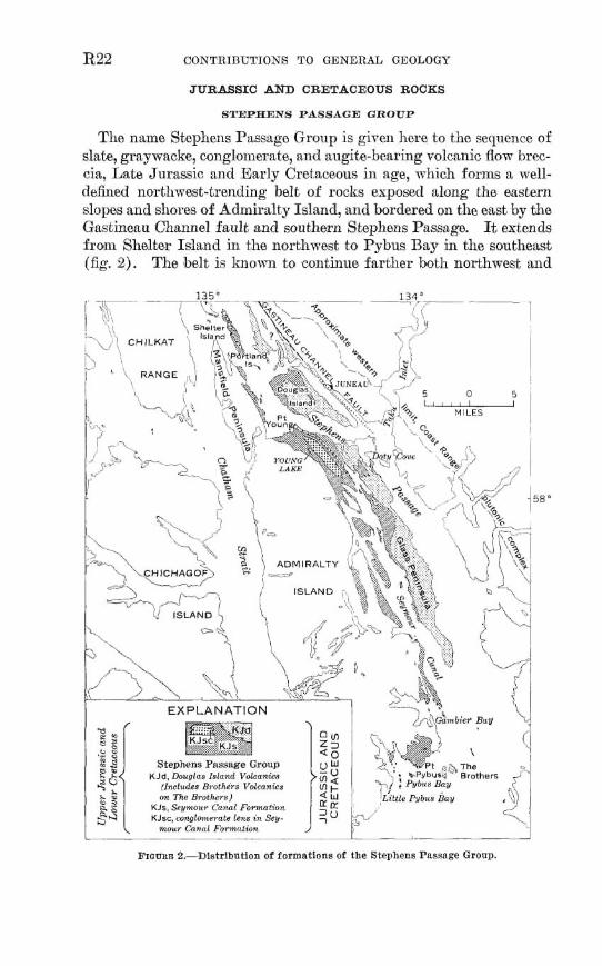
The name Stephens Passage G m p is given here to the sequence of slate, grnywacke, conglomerate, and augite-bearing volcanic flow brec- cia, Lab Jurassic nnd Early Creiamus in age, which forms n mell- defined nortl~w&-trending belt of rocks exposed along the eastern slow and sllores of Admiralty Island, and bordered on the east by the Gas tineau Channel f ~ t z l t and sou them Stephens Pass;sag.e. I h extends from Shelter Island in the northwest to Pybus Bay in the southeast fig. 2 ) The belt is known to continue farther both northwwt and
southeitst (Buddineaton and Chapin, 19291, but the stratigmphy in these a- has not ;ret been studied in detail. The name of the gmup is taken from its type locaIit;r, Stepllens Passap, the mterrrny between Admiralty and Douglas Islnnds dong whi c11 the f orrnat,ions that the g~oup comprises are best expe~erl. Tho forma.tjona nro the Seymour Cannl Formation, the Doughs Islmnd V d ~ m i c s (radefined) , and the Brotlzers Volmnics. The thiclmess of the ~ O I I ~ is unlcnmrl, but may exceed 10,000 feet.
The Seymour CannF Fornlntion is composed mainly of slnto utd graywacke. It includes all tlla erpowd rocks of the p u p in the mestern part of the ot~tcrop belt nnd is the lowe7t formntion of t h ~ group in the enstern pnrt.
T i th in the Seymour Canal Forn~ntion: ~ ~ r l l nlmrc its bnse, largo Ienses of paytrncke ~ o n g l o r n ~ r ~ f PI c ~ n ~ p m t l of IT)IIII~PC? CIRS~S O C T E I ~ .
These 1enPes grade into tlw slnte al~rP gnywncko Imt 11 ~erlicnlly nnd laterally. The largest l ~ n s e s are sho1~11 on C F ~ I I - C 2.
3'118 Douglas Islanil 1-olrari ips C O I I F ~ S ~ $ principn11~ of nugita-bearing 1-olcnnic flaw breccia and some tuff, g r f i y ~ n c k ~ , nnd slnte. This for- mation forms the mn.jor pnrt, of t 1 1 ~ St~pllelis Piissap, Group in the exstern part of the oiltcrop lwlt. 'I'hn J3mthws TTolc~~lics RE a litho- logimlly ~irnilar hut gcogrnphicnIly rliscrete Ixlcly of rocks ml1ic11 may bo n 1e.n~ in tho Seymo~rr Cnnnl Format ion or nltly be eq~zivalent to the Douglns Island Volcnnics nnrl n, souzhern mntiriuation of the Douglns Is l~nt l Volcnnics outcrop 1 ~ 1 t. Tho I;I tter interpretation js show1 in figme 2.
The formnljon~ of the SiepI~ens Pnssngc Group scem to be inter- rslatad pnda of n single dapositionnl s ~ q n a r c e (ins&, fig. 2 ) . The nnture of the formnt.iol~nl contnrt s on Glxss P e ~ i ~ f l l h and Dongllas Islnnd show concl~~sively t,hnt tho Donglns Island Volmnics wnfonn- nhly nnd pradntionally overlie the Inn-er pxrt of the Seymour Cand Formntion. I~enses and lnyers of volcnnie breccia idcntiml to tbe main rack type of the Douglns Islnnd Volcnnics Occur tliroughont expsilres of tlw Seymour Cannl Formntian to the rest,. Slate and graywxckn am interbedded wit11 the volcnnic breccin both st the top and botttom of the nouglns Islnnd Volcanics ~ n d occur ns Irtrge irregular bodies mithin the breccin. These data sirggest thrtt tho Douglas Island Tnl- cnnics occupy m stratigraphic interval equivalent to a t lonst s part. of tho Seymour Canal Fomntion and that, t,he two formations inter- tongue along XIie central zone of the on tcrop belt,.
The Stephens P w Gronp is Late Jurassic and Early Cretaceous in n p , Fnssils have been found only in the lower part of the S~yrnoilr CnnaI Fom~nLion. They xrs Rimmeridgian to Portlnndian (T.,ate IT~trassic) xnd Berriasian (Early Cretnceons) in nm and were col- lected from beds not separated by an apparent disconformity. Sii~ce
R24 COUTRIBUTIONS TO GENERAL GEOLOGY
the fossils were not collected from the basal beds, the possibility that Middle and h w e r Jurassic be& exist cannot l e ruled out,. The Sey- mour Canal Formation is overlain with angulnr unconformity by heda of Paleocene qp st Little Pybus Bay (Loney, 1964) ; thus the group is no youmger than Late Cretaceous. On Doukrcs Idnnd, tJhe I)ougl!tns Island Volcanica am o~erlain mnfomnbly by tho 'rreadwell Slnk, considered Jura$sic(?) to Early Cretaceous(!) by Enrker (1957) . Fnture mapping mny slmm tho Treadwell Slate to be a part of the Stephens Passage Group, but at present the mlntion of this formation to the Seymour Cand Formation cannot be clearly defined, and the Trendwell Slate is emladeed from the p u p . On Mansfield Penin- sula the Seymour Canal Fomat.ion conformably overlies the D d o w Cove Formation of Perqninn nnd Triassic(?) ago /T3arker, 1057; Lathram and others, 19601, mid farther muth on A.tImisnlty Tsl~rld the Seymour Gmnl Fornlntion djxon formnbly orcrlies the Hyrl Formn- tion nf Late Triassic rage (L~thmm nncl or hers, 1900; l m ~ g , IOGC) .
8EPanOUR CANAL FORMATION
Dbtribzction afid 7~th.olo~y.-Slak, graywncke, find conglomerate forin a broad aren around I'ybus Bny and extend RS n balk that trends roughly N. 3O0 W. from Grtmbicr Bay along Seymour Canal to Young Ray and Stephens Prtwaga (pl. 1). Sonth of Pybus Bay, these rocks crop out only on thc, nortl~east, shore of Herring l3ny. In the Pgbus and Gxmbier nays area, Loncy (10R4), named thaqe the Seymour Canal Formation, a name which is applied to the entire belt in thia report. Ch Mnnsfiold Peninsuln, Bnrker (1967) named and mapped the Sy- monds Formation, which, by ~nrtlogy wihh the rocks at Pybus Bay, he bol ieved to lm Rarly Cretaceous{ ?) in age. The cumnt mapping IIRS shown that the exposures of tho Syrnonrle Funnation at Symonds Point on Admiralty Islnnd nre a. northwarci continuation of the lon~cr pnrt of the Seymour Canal Formation. The Symonds Formation is tl~erefow strntipphically below the Douglas Island Volcar~ics (p. l?23), mther than rtbove, tts Barker bdieved. Further, rocks of the Symonda Formation are unfossiliferous and are genedl y exposed in widely sepnmted and discontinuous outcrops. Consequently, these rocks am mapped as the Seymour Canal Formation, and the name Syrnonds Formation is here rtbandond.
Slate and slaty asgiTlite are the dominant rock types. The slate is dark gray to grayish black and cuntains sparse cdcareoua beds. 'She slaty argillite is dark p y and commonly contaiils beds of lighter g r ~ y siltsston~ that show g m d d bedding and shirnp stnictnres. Slnty cleavage is poorly developed and wide^^ spaced in the fine-pined m L s south of Gamhie-c Bay but is progressively mbtter developed nncl
more closely s p y to the north. The slab in the Young Bay a m is very fissila
The grqwack0 is medium to dark gray, fms to coarse grained, lithic, and commonly calcareous. Graded bedding is common. Slate par- ticles predominate in the coarser grained graymacke. South of Gam- bier Bay, the graywacke sllows little or no internal deformation, but eastward and northmrd in the belt of outcmp it bmrnes progressively more foliated and in the Young Bay area is schistose.
Conglomerate forms t.l~in discontinuous lenses interbedded wit11 the slab and gmywacke at many plam throughout t he section. Thick units of conglomerate crop out nt PoEnt Pybns, on the islands in the mouth of Pybus Bay, and on the ridge betsreen Young Lake and OIiver Inlet. Thwo thick units are shown separately on the geologic map ( pl. 1) . A co~~glomerah be1 t several hundred feet thick within the slate snd pywacke that extends nearly continuously from Point Young southeastward to the head of Sepous Canal is also shown on the geologic map. The conglomerate is thickly bedded to mrtssiae, and its clash range from pebbles to cobbles. Sorting as to size is poor. The dasts are well rounded and imbedded in a pywrtcke matrix. The most common clasts are argiIlite, banded graymscke, Eight- ta medium-gray limmhne, marbl% felsite, quartz, chert, grmih, and quartz diorite. Dark-py to black argilIite frkoments form the domi- nant clasts in the Young Lake area, and are abundant but snbordimt~ to limestone and marble clmts in the Pybus Bay am?.?. Pebble counta made at several places indicate that the composition is exttremely vari- able. 'She conglomerate st Point Pybus intertongues laterally with slab and graywaclre both at the northern end of the outcrop and to the south on the San Juan Islands. The mngIomerate east of Young Lakbke is exposed as rt high, resistant ridge nbwe a lowland composed of less resistant slata and gmywacke. The beds of this conglomerate am believed to have intertowed I atmlly with slate and p y w a c k e dso, but t h w less-resisbt lateral equivalents have been m o v e d by erosion.
Tke mnglomerata on Shelter Island mas mzpped as part of the Shelter Formation by Barker (1957), who mgpstsd that this con- glomerate "may grad0 by B fncies change into the Symonds formation on Douglas Island * * *." The IithoIogg and relation of the con- glomerate in the Shelter Formation to the slate and gmymacke se- quence are similar ta those of the conglomei.ate lenses in the Seymour CsnaI Formation to the south. This similaity suggasts that the Shelter Formation is a simiIar lens and future mapping may prove it ts be a member of the Fmyrnour Canal Formation.
Thin layers, lenses, and concretionary nodulw of Timeshno rwxur locally,as at HerringBay. Zensesandlayersof voTcanicflom breccia
that contain conspicuous phenocrysts of wgite we interbedded with the slab m d graywacke on Horse Island (Barker, 1957), on the small island southwast of Point Young, on the shore between Point Young and Oliver Met, on Bug Island in Ssymour Canal, md at seveml places along the west shore of Glass PenimIa.
Blmk pyritic slate crops out on the shore of GI= Peninsula op- posite Grand Island. Pyrite nubes are unugudly large, and cryshls an inch Iong are wmmm.
T h i c h m arid stratigmphic relath.-Ths thicknw of the Sey- mour CanaI Formation is unknown bemuse intense folding and lack of marker beds preclude accurate measurement. In the Pybus Bay arm, Loney (1964) has estimated a mhhm thickness of 4,000 feet md believes the formahion may be as much as 8,000 feet thick. The conglomerah lens east of Young Lake is appmximatdy 3,500 feet thick.
The S e p o u ~ Canal Formation disconfarmably overlies Triwsic rocks (p. R20). Along most of Glass Peninsula, the Seymour Canal Formatim is werlruin by the DDuglrta Island Volwicsl in normal stratigraphic eequenw, nnd the contact is conformable and grada- tional. Near the head of Seymour Canal and east of Swan Islm& large a m underlain by m h of the Seymour Canal Formation lie on the projection of the strike of beds of the Douglas Island Volcanics. This change in rock type is probably the result of lateral intertonguing of the two formations, but the contacts are covered rand cuuld not be studied. At Little Pybue Bay, the Sepour Cmal Formation is over- lain with angular unconformity by Tertiaq rocks.
Age- a d carreZ~iu%-Fo&18 in the slate and graywacke of the Seymour Canal Formation ham been colleehd in the Pybw and Gambier Bays area (Loney, 1964) and also ah Herring Bay (pL 2) . Those in the former area axe charracterized by the peleeypod Bu.cItia and range in agn from Late Jurassic (middle Bimmeridgian) to Ewly Cmtaceous (Berriasian) (Ihney, I%), At Herring Bay, B~eh ia cf B. m ~ i c o Z Z h (Keyserling) was collected. This $mil was identified and assigned an age of early Early Cretawow (middle to lab Valan- ginim) by N. J. Silberling, assisted by D. L. Jones of the U.S. Geo- logid Survey (writtan commun., 1959). This evidence supports the assignment of the Seymour Canal Formation to Late Jurassic and Early Cretmtmus age by Loney. One poorly preserved bryoman fragment was found ws a pebble in the conglomerate east of Young Lake. Thia find wrves only to indicate that the conglomerate was deposiM in pasbPermian time (Jean Uerdnn, W.S. Geological Sur- vey, written commnn., 195'1). Sewd Early hbmow (Bexri- asim) ooll&iona are associatad with the conglomerate at Poht F'ybus
RECONNAISSANCE GEOLOGY OF ADJ6XRALm ISLAND, ALASKA R27
and give a~ better indication of its age. Fossils of Lake Jurassic and Early Crehxous age am found near each other. Loney staks, in reference to these murrences, t ha t the Lower Cretaceous beds are generally east of the Upper Jurassic beds, but there is no evidence of a statigraphic break between them.
An outcrop belt of slate., graywacke, and conglomerate similar to the rocks of the Seymour CanaI Formation continues from Pybus Bay northwestward through Stephens Passage to Bemen Bay. In the Bernem Bay and Eagle River am% Knopf (1911,1912) included thw rocks in his Berners Formation, s name now ~bmdoned.
The blt of slate, gray w d e , and conglomerate also mntinues swtll- eastward from Admiralty Idrtnd (Buddington sand Chapin, 1929), but detailed mmlation in this area is not yet possible.
A thick sequence camp& mmtly of angite-bearing volcanic flow breccia forms a belt that underlies most of Glass Peninsula. This belt, projected northwestward along strike across Stephens Passage, win- cides with a belt of lithologically identical rocks thnt form the main F i d p of Douglas Island and which were named the Douglm Island Volcanic Group by Martin (1826). The rocks form a coherent map- pable unit not suscaptiMe to subdivision over broad areas, which is bere r e d u d to formation status. Accordingly, the volcanic m k s ex- posed on Glass Peninsula am mapped FLS the Douglas Island Volcnnics.
Distinctive porphyritic volcanic flow breccis is tho dominant mck type. Clasts a m camposed of the srtme material as the matrix and seem to consist of solidSed fragments of a flow incorporated by lahr movement of the flow. The phenwysts are as much as a half inch in diameter and are genemlly augite, although hornblende is common; feldspar phenocrysts are rare. The angite p h e n w s t s are set in a dense grayish-green to green aItered basaltic or mdesitic groundmrass. The breccia is generally massive, and bedding planes are poorly devel- oped. It is the most common rock t y p in the highland meas of Glass Peninsula but is less widesprettd along the eastern shore of Seymonr Canal. On tho eastern coast of the peninsuIa the breccia is schistow. Massive md ahistose nonporphyritic flows sre dso prmnt but un- common. A few thin tuff beds also occur. The flows ~ n d tuff beds are limited to the lower part of the section and are interbedded with slaty argillite. Slate ia commonly interbedded with the breccia in the highland areas.
The Douglas IsIand Volcanics conf omably overliea r o b which are a part of the Seymour Canal Formation, and the contact between the two units is gradational. Sedimentary structures of the siltstone and
w CONTRDWTIONS TO GENERAL GEOLOGY
graywacke beds underIying tihe volcanic rocks show that the section is upright. On Glass Peninsula, beds of the Douglas Island Volcanics probably intertongue laterally with beds of the Seymour Canal For- mation (p. R26). The thicknm of the Douglas Island is ~ariable, but it is at least 3,000 feet. The Douglas Island was considered to be late Jurassic ( 8) by Martin (1926, p. 255-2561 and Jurassic ( ! ) to Early Cretaceous ( l) by Barker (195'1). On the basis of the stratigraphic relation of the Douglas Island Volmnics to the Seymour Canal For- mation, the p m n t authors assign the former a Late Jurwic and Early Cretaceous age.
Volcanic rocks crop out along the mainland northmt of h g l a a Island and extend northwestward almost to Berners Bay. They are identical ljtbologicalIy to the Doaglas Island Volmnics and have been correlated with this formation by many previous workers (Spencer, 1906; Knopf, 1911, 1918; Eakin, 1918, and unpublished dab. 1922; Martin, 1926 ; B u d d i i n and Chapin, 1929 ; Barker, 1957). Similar rocka have been reported ta the south (Buddington and Chapin, 1929) amciatd with the belt of Jurassic and Cretaceous graywacke and slate that trends muthmst through Kupmanof Island and east of Clarence Strait.
BB-EI OOXAldN'XC8
Volcanic mks similrtr to those of the Douglas Island Volcanics compose the isolated Brothers Island and were named the Brothers Volcanics by h n e y (1964). Thwe rocks are geographically discrete and may prove to be either a lens in the Seymour Canal Formation or equivalent to the Douglas Island Volcanics as a southern continuation of iki outcrop belt. The Brothers Volcanics is mapped with the Douglas Island Volcania in this report.
Dhh'hEion arad Dtbbgy.-The Kootzntthoo Fomrttion (new name) is here named for Eootznahoo Inlet, along which typical ex- posures may be seen (pl. 1). The formation is composed of nomarine clastic rocks. It mainly mupi@ the lowland bounded by Favorite Bay, Ranalku Bay, Davis Cresk, and Mitchell Bay on the west, southeast, and east rtnd the low foothills northwest of Kmtmahoo Inlet and Mitchell Ray. Favorite Bay and Davis Creek appear to lie along the traces of faults. The strike of the beds, which is generally north in the southwestern part of the area, changes gradually to north- east in the central and north-central parts and to northwest in the eastern part. The prevailing dip is about 45" in s eouthaasterly or easterly direction.
Similar rocks form a belt which underlies mast of IitEle Pybw Bay and continues north nearly to Cannery Cove (pl. 1). h n e y (1984) has suggested they are rougl~ly mmlative with rocks herein calIed the Kootznahoo Formation, and they are mapped with the Kmtznahoo Formation in this report. The regional dip of this belt is approxi- mately 15" to the west.
The dominant rock types in the Kootznahoo Formation are pebble to cobble conglomerate, fine-grained to wnglomeratic arkosic mnd- stone, lithic snndstone, calcareous siltstone, carbonnceous shale, l ipite, and subbi twninous coal. Conglomerate with litlcc sandstone matrix consltitutes most of the exposures northwest of Kootzn2hoo Inlet nnd Mitchell Day. Minor conglomeratic sandstone, siltstone, and shale are interbedded with the conglomerate. Along the north shores of XCootx- nohoo Inlet and Mitchell Bay, the congIomerate is rnotierately to well cemented and is poorly ta moderately sorted. Pebbles are commonly black, gmy and white chert, and light-gray quartz, Argillih, phyllite, shnta, and dark-gray schist fragments are also common. Grnywacke pebbles are less common. Plutonic rocks similar to types found in the batholith at Thsyer Lnks occur as clasts in the conglomerate on the northeast shore of Mitchell Bay and along Freshwater Lako, On the northwest side of the prominent hill 4 miles north of h p o n the con- glomerate conbins poorly &ed elasts of black chert, ~rgillite, and p a y quartz as much as 4 inches long. At tha top of the hill, black argillite clasts pdominata
Southwest of Kootznahoo Inlet and Hitchell Bay, sandshne, silt- stone, and shde make up nost of the formation. The arkosic sand- stons is friable, and beds commonly show crossbedding. The carbona- ceous shale commonly contains abundant plant fossils, particularly at Sullhnn Point and Diamond Island. Coal beds and lenses that are as thin ns 1 inch and rarely as thick as 4 feet are locally intercalated with the he-grained sediments. Conglornernto crops out d o n g the east shore of ITavorite Bny, but anstward it p d e s rapidly into srtnd- stone and siltstone. Pebbles of black phyllite and nrgillita are the dominant constituents of the conglomerate at the moutll of the bay; the phyllite and argitlite decrense in nmount southward, and at the head of the bay am qualled in amount by gmy and white chert and quartz, Scattered but conspicuous congIomerate beds of mil lateral extent are found near Davis Creek between ICnnalku and Mitchell Bays.
At Little Pybus E3ny t l~e fomntion comprises coarse-pined lithic sandstone and conglomerate. Pllyllite fragments are especi~lly a b u - dnnt in the sandstone. The conglomerate contnins rounded pebbles snd cobbles of diorite, basalt, paywacke, pllyllite, and quartz, n11rT the matrix resembles the lithic sandstone interbeds.
Thich8a and sf~atigraphic ~e.elatk.-The thickness of the Kooh- mhoo Formation is only approximately known. Faults whose strike parallels thah of the bedding have bemi found a d are believed to be abundmt. The faults are believed to be normal ones on which the northwest side has moved down ; thus the beds m duplicated. The formation is believed to be wedge shaped, the thick& a m occurring muthetist of ICootznahoo Inlet. This thickness is probably about 5,000 feet. The geetion a t Little Pybus Bay is approximately 8,000 feet thick (Loney, 18641, but the formation thins northward m d disap- pears south of Carney Cove.
The Kootznahoo Formation lies with angnlar unconformiQ on the Gambier Bag Formation at the southern end of Kanalku Bay and on the Seymour Canal Formation at Little Pybw Bay. In Ilmtznnhoo Inlet, the Ktznahoo Form~ttion unconfoma bl y overlim plutonic rocks. In tIw type area, the upper surface is erosional, and no younger bedded rock occur. In the Little Pybus Bay area, the formation is overlain conformably by the Admiralty Island Volettnics. The conglomerate md finer sediments of the Kootznahoo Forma-
tion are believed to represent temporally equivalent f acies within a wedge-shaped body of terrestrial sedimenb Conglomerate waa de- posited near the source and graded laterally into finer sediments away from it. Coal beds are associated with the finer sediments.
Age and correlation.-Fossil flora have been collected at several localities in the type area. Eclmin Kirk (unpublished data) in 1918 mllwted material which was identified by F. H. KnowIton. Rnowl- ton's report has never been publisked; he assigned the sequence to the Eocene and stated that the flora was similar to that found in the Renai Formatias of south-central Alaska.
Fossil flora from the Kootznahoo Inlet a m were colleded again by 5. A. Wolfe of the U.S. Gmlogict~l Survey in 1961 (pl. 21, and his report is as f ollowa (written mmmua, 1963) :
Mod of the forrafl plants collected mrn the Kootmahoo Formation are poorly Premrved, and thua many speciflc and nnenlc determiaatiom are of querstion- able value. Nevertheless, the lowegt floras are strikingly diflerent from tho= from the highest part of the mctlon collected, and a thhd type of flora o m 8 between these other two floras.
The lowest flora coUected (loc. 9822) mntains "ITEmua" ~8&0&btw@, Ocotea ap., Dilleniaceae, and Dr#ophp6Eum sp.; them forms are fonnd In floras tlmt am in the upper half of the Eocene or lowermost Oligmne. NotabIy Lacging from the flora at 9822 are Betulaceae, Aceraeeae, and Salicamae. Tfie middle type of ammbIage in tbe Kootznahw Formation (localities 9826,
9&28, 8827, 9829) i 8 dominated by Uawa mgw.la Jugram &taUs, dlwa alaskmn~ Uwctdiph~1lum aff. 0. m a t a r m , VIM8 atwood& PopuEurr m, and ''Picud" alaehmr. It i s difficnlt to determine the age of this amemblage because most of the speciesl are endemic to tbe Kmtznahoo, or, I f known from other Alaskan floras, occur in floras who= age Is also somewhat in doubt. Several of
RECONhTA18WCE GEOLOGY OF ADMIRAIIlPT BLAND, ALASKA R31
the spedes listed abwe were oMnally mid to have mme from Cook Inlet (New- hemy, 1883) and would therefore be from the Iteml Fozmatiw. It ie almost certain, however, that the smimens were mislabeled and actually came from Kootznahoo Inbt. 0. mopnlfioa and 6. r3rJeniaEia are restricted to Oligocene rocks elsewhere In Maaka and the Xortbwest, and i t is probable that the mid- dle Kootznahoo assemblage ia Otl~ocene, although not i n the rarllest part of that epcwh. There are fiome differcnm between the various floras of the mld- rue t g ~ e of assemblage+ bnt the cullections are too smnll and m r l g preserved to consider the age significance, if any, uf these diff~renees.
Tbc highest Rootznnhoo assemblnge (localitleu 9624, 9826, W 8 1 mntaLne Fama antipop, Quercua lumhjelmi. Conrpionla naumanl, and Poputaa Undflreni. This @pe of flora Is typical of other rucks of early 31loccue age in Alnskn.
Thus the floras from the LtyPe aren of the1 Kootznahoo Formation indicate that lthere] this unit contabs rock8 ranging In age from probably lata Bloceue through early MIncene.
Fossils were alao collected by Wolfe from the beds nt Little Pybus Bay. Concerning these Wolf e atates (written commun., 1963) :
The flora from loc. 9P31 contains: Qlt!pbo$lroBua cf. 0. aordmskiold4 Meta- neqwira occidmtalb, DIaon pmespinwlnsum, Laurue AonitUotlesaeia, M a l p o ~ m a rnagnificcs, $aasa$rar olaakosum, and fiillenjfea mhodnrtatra. All of these spccies ocrmr in the Tertiary flora on Hnmllton Ray, Kupreanof Island. The age of the Hnmflton Bay flora is based on the occurrencp of smeral m i e s characterlWic of the I'nlcocene In North America: Onnclea heaperia, Carurn anliquoro, "Qwmua dariL~ti,s' and Planera mfcropAplla. The lnck ot these species in the present cdlectlon from loc. 9K?1 is grobnbls a fi~nctlon of the m a l l cot- Iection. The high degree of mnawtflcitg between the Hamilton Bny and Little Pybna Bay floras indicntca a ~ImIlar age, that is, Fal~oeene.
On the basis of the fossil evidence, the Rootenahor, Formntion aa mapped in this report is considered to be Paleocene through Miocens in age. To the north, sedirnentaq rocks which may be comlati~e have been fonnd underlying the voIcanIc rocks of Pleasant Island (Lthrarn and others, 1959).
D G t f i h t ; , a d J i t h o l d g y . - ~ ~ Admiralty Is1 ~ n d Volcanics (Lo- ney, 1964) occupies an area of roughly 350 square miles on the south- ern end of Admiralty Island. These volcanic rocks extend northward to the North Arm of Hood Bay on the west coast and virtually to Pybns Bay on the southenst coast. They form s broad elongnte basin whose axis tmds rough1y northenst. Older rocks are exposed only on the perimeter, in unconnected areas at Chaik, TVIiite~vnter, Hood and Herring Bays, and in the area east of Murder Cove. In general, the strata incIine toward the center of the basin at angles of 25" or Isss. T h e formation consists of basalt or andesita flows that am commonly
dark gray and less commonly Iight gray, grayish green or red. A rep-
mntative suih of 31 ~amplm was mllected for thin-section study. The ~su1t.s show that no significant mmpositirmai or textural change occurs either dratigraphicrtlly though the sequence or laterally across the outcrop a m The flows am commonly sparsely porphyritic and often contain phenocrysts of labradorite-bytomnifa and itugite set in a finely crystalline groundmass. Phenocrysts of olivine are tl~lmmmon, and hypersthene was noted in one thin saction. Soma flows are scori- nwous ; others contain arnygdules of calcite and chalcedony. Tuff and breccia beds are commonly interlayered with flaws in the lower part of tho sequence. FeIsic m k s nre rars. Near Cannery Cove and en the w ~ t side of Chepin Bay, felsia tuff and breccia beds occur. An aItored felsic flow is exposed in the highland area 3 miles west of Herring Day,
Lmally the flows are altered and sheared along major linears be- lieved to ba faults of considerabla displacement. Along a fauIt zone an the west sida of Surprise IIarbor, the flows are intensely sheared and tare mottled red nnd green, Along the Eliza fault complex folding can be seen on the east; side of Eliza Harbor about 1% miles north of =moi Island.
liz several places sedimentary sandstone md conglomerate a m intar- 'bedded with flows and tuff beds at the base of the Admkslty IsIand Volcanics. Although some of these sedimentary rocks are lithologi- call y similar to and may be comlstive with the Xootmahoo Forma- tion, they am all tao ma11 in oatcrop area ta map separately and are therefore included with the volcanic formation. A typical exposure is a bnsalt pebble conglomerate at Whitewater Bay, 1 milas southeast of Iron0 Tree Islet. The largest exposum of these rocks form the east side of tlze peninsuIa separating Surprise Harbor from Murder Cove and extends through the head of the cove for an unhomn distance north- w a d . On tho peninsula a homoclinal squenca of bwlt ic flows, ar- kmic sandstone, tonglomerate, and breccia is exposed. Coal beds occur 2 miles nodh of the head of Murder Cove (Wright, 1906, p. 152-153).
Thickn-488 and ~ltratigmphic .re?ath.-Volcanic mks 9,500 feet thick have been measured in s continuous section west of D o d q Bay (hney, 1964). This section, on the emtern edge of the basin, is incom- plete because the top is eroded. ?Vestward, toward the center of the basin, younger flaws occur. Although the area is faulted, the y m g e r flows are probably as rnucl~ as 2,000 feet thick, The total exposed thick- ness, therefore, is about 10,000 feet, but because the top of the formation is everywhere an erosion surface, the original thicknm is unknown,
The Admiralty Island Voleanics lie conformably on racks =signed t~ the Kootznahoo Formation in Little Pybus Bay. el sew her^, the formation lies wit,h angular unmn f ormity an pre-Tertiary rocks. This
contact is axposed nmr Rerring, Chapin, Chaik, Whihwater, and H o d Bays.
Age and cowelatton.-Fossils have been found within the dimen- bry mks interbedded with the volcanic rocks at Murder Cove. Of these fossils, J. A. IVolfe (taritten commun., 1961) states:
WP--8114. Coords. w Sitka (A-2) quad., 1 :63,360: long W34'00" W., lat b7"1'20" N. (5.74,1.48). Murder Cow.
F w l b idea ti8ed : Conifers :
Metlsrreqrroia plyploafmboide8 Hu and Chew Dicot : A h u s aEaskanu Newb. AcCT A&
Age: The collection from Mnrder Cove Ea small, and the Eeavea are not well premrvd. Tlre presence of Alfiur aIa8kana indicates a comlaaon with the mIddIe Kootznahoe ammblage, and hence an Oligocene age Is probable.
Inasmuch as the formation mnfornably overlies Paleocene pocks at Little Pybus Bay and contains rocks of O l i p n e age near its base, it is considered to b Eocene and Oligocene in age. Buddmgbn and Chapin (1929) correlated this formation with the volcanic mcks of Kuiu, Kupreanof, and Z a m b o Islands which they considered to be of Eocene(?) age. To the north of Murder Cove, volcanic flows of wmparabIe age an tnd lithology crop out on Pleasant Islnnd and on The Sisters in Icy Strait (Lathram and others, 19591,
Unconsolidated sedimentary deposits consist mainly of alluvium, glacial material, and .talus. High-level terraces of fossiIifemus marim ,oravel, sand, %nd clay occur in places, but these deposits a m h o small to be shown at the scale of the map,
KNDIFf ERWTIATED HETABTORPEE ROCKS
Some of tl10 racks have been so mctarnorphosed that cribria for dis- tinguishing stratigraphic units have been obscured or destroyed. These units have been combined into a group of undifferentiated metamor- phic mcks an the map (pl. 1 $ . Parts of tlie group are contiguous to the less metamorphosed formations that rrtnge in nge from Devonian to Cretaceous. The most widespread rock types are hornblende-albite- epidota homfels, rnicnceous schist, metamorphosed chert, coarse- p i n e d marble, slate, and phyllite.
The largest, arm underlnin by these m k s is a belt about 25 miles long extending f ram Mount Distik and Yellow Bear Mountain northwest to Ward Creek. This a m is parkly bounded an the wagt by the batholith at Thayer I ~ k e nnd on the east by the plutans betwean Hasselborg Lake and Pleasant Dny.
It3 COhTRI33UTIONS TO GENERAL GEOLOGY
k extensive metamorphic mks are associated with two intrusive bodies north of the mest end of the Garnbier fault. The nature of the western part 02 these rocks is little h o r n ; the terrttin is low and m~ered, and outcrops are scarce. Small masses af hornfels wcur muth and west of Point Arden and are associated with the intrusive body at Doty Cove.
mGXATITE, GNEISS, AND FELDSPATBXC BCHIST
Three large areas of mixed rocks, closely associated with exposum of plutonic rock, have been rnnppcd saparately (pl. I). They consist of rn ipat i te , of gneiss, nnd of several types of scIkd t h ~ t wntain large porphyroblasts of feldspar.
At the east end of Lalm Florencq an area that contains poor ex- posures is underlain by llornblendo-biotite-quafiz-plagioclase gneiss and hornblende-diorite gneiss. In the high mountuins northwest of Hasselborg Lake, gabbroiq dioritic, and granitic plutonic rocks are mixed with hornfels, schist, and arnphiblite.
The largest mass of migmatita and gneiss lies west of the head of Seymour Canal, but its enstern exposures are poor. A m a l l granite body, whose boundaries are gradntional wit11 the surro~mding gneis, crops out near the center of the a m . The gneiss differs in mineralogy depending on metamorphic grade and originnl cornposit ion, but in pn- era1 these rocks are characterized by thin layers of qunrtzsfeldspathic rock alternating with mica and chlorite sehists and ampl~ibolite. Porphyroblasts of plagioclase, as much as several millimeters in diam- eter, are common in a1 I the rock t y p Thesa porphyoblnsts as well as the quartzofe'ldspathic layers decrense irr size and number away from the center of the migmatite a m . There appears to be a correspond- ing decrease in metamorphic grade, but the meager petrographic dnts do not permit determination of the metamorphic zones or facies repre- sented, The quartz-nlbite-epidote awiat ion , indicative of the p e a - scl& or dbibepidote hornfels fwies (Fyfe and others, 1058) appears to be widespm d, w h e w the calcium-bearing plagioclnne-hornblonde nmciation, indicative of the drnandine amphibolite or hornbIende hornfels facies, appears to be more restricted arenlly. The following are representative rock types: quartz-andesine-11omb1end~~biotito am- phibol i te, an d~ins-garnet-pyroxene gneiss, qu adz-andesine-diopside- rnicrocl ine-ealcite gneiss, qugrts-albj te-chlorita-epidote schist, and quartz-albite-chlorite-biotite-epidote schist. Chloritization and mi- citixation are widesprezd in thehigher grttderocks. Granite p e p - tite dikes are Gammon in the feldspathic schists along the northeashm boundary of the area.
RECONNATSSANCE GEOLOGY OF ADMTRALTY ISLA??, A t A B m m5
Plutonic rocks are exposecl over nbout 10 pcrcent of Adrnimlty Island. They range froin felsic to ultrnmnfic types9 but most are of intermediate composition. ~ ~ u s o contacts with the intruded rocks ars genemIly covered, diecusions of relntionsllips are largely inferential.
EELSIC PLlJTONXC ROCK8
Allnnite-biotite granite, hint i t e-qllnrtr. rnonzonite, and quartz-albite- micmlino pegmatite form n srnnIl plutonic body surrounded by mig- matita a few miles west of Icing Salmon Ung. Rearby rocks as young as Jurassic and Creinceous bavt: hcen metamorphosed.
A batholith that underlies almost 150 squnro miles is centered &round T h ~ y e r Lnke to the north of Koatznahoo Inlet and extends inland abaut 16 miles from the west canst of the island. Analysis of a few thin sections shows that tho dominant rock constituents am hornblende-bio tite quartz d iori te, Ilornblende-biotite granodiorite, and biotita granodiorite. Small bodics of hornblende gabbro are scattemd throughout the batholith, and pink granite underlies a small area at and north of Thnyer Lake Lodge. T h e contact between the batholith and adjacent rocks is generally covered but is apparently crmutting. Near the contact the effects of contact metamorphism have, in mmy placw, hen superimposed on those of regional metamorphism. On the west coast of the island, l o w - p d e whist, marble, and chert of tI10 Retreot Group hnvo been altered to nmphihlite, biotite-hornblende- garnet schist, pmet-epidote-calcite rock, and sugary-textured quartz- ite North and emt of the batholith, the rocks have been meta- morphbseti ta gneiss and hornfels. The southern border of the batho- lith is mostly covered. Rocks of the batholith a m p r l y to well foliated, but the trend of the foliation relative to that of the invaded rocks was not studied in detail. Strnts raneing in age from Devonian to Early Cretamous have been metzmophosed. Rocks of the Kootz- nahoo Formation near the batholith are unaltered, and ithe condom- erute beds at MitcI~dl Bay contain a sparse momt of pebbles lith- ologically similar to plutonic rocks of the batholith. Hence, the batholitl~ pmbnbIy mas intruded a h r Early Cretaceous time md prior to PaIeocene time.
Other small plutons that am lithologically similar to the batholith at Thayer Lalze crop out at, and to the northwest of, Raselbrg h k e , at Mitchell Bay, between MitcI~~ll and Gambrier Bays, north of Rood Ray, and on the west coast of the island near Fishery Point. T h w plubns are probably sabUites of the batholith.
R36 CQNTTEXB'IJTIONS TO GENERAL QEOLOQY
Barker (195'1) has discussed the pluton that f o r m the wmtorn part of Mansfield Peninsula fmm False Point Betmat to a p r l y dehed c o ~ e 4 miles south of Funter Bay. T h e pluton mnsists mainly of albite-oligoc,lase-biotite qusrtz diorite. It is linenfed, well folinted, and shearecl. The trend of the foliation is parallel to that of the country mk. Rarker indicates that the pluton wrrs intruded after the formation of the distosity in the Wmt Gmup and th2, after mlidificrrtion, the intrusive rock was deformed and r n e t a m o r p h d in a later stage of the omgeny.
The plutonic mks exposed on Gmnd Island and a m d Doty CbVs and Oliver Inlet are probably parts of a single a k , The mks &re dominantly hornblende-biotik-quw* diorite. The mntact with the country rock is genemlly mmled, but is apparently c-utting. Them are wveral mall areas of hornfels djacent to the conhct on the northeastern coast of Glass Peninwla; however, contnct rnetrt- rnorphic effecta am not widespread. Some phltses of the pluhn are directionlm and some am poorly to moderntaly foliated. Ju-ic and Cretaceous volcanic rocks, slat@, and grrtywacke have been in- truded and metamorphosed by the pluton.
The three small bodies of possible plutonic rock immediately north of Beaver Lake couId not be examined in the field owing to vegetative cover. These bodies mere rnspped by photointerpretation, and their composition is unknown.
BUFIC AND U ~ ~ ~ A M A F W ~LVToma ROCKB
Mafic and dtrsmnfic plutonic rocks crop out at and near Mole Har- bor, near Point Marsden, and in the mountains southeast of Rawk Inlet. Tha largest body is near Plens~nt Bay and Mole Siarbor. It is predominantly hornblendite and foliated, ssussurjtized augite- hornblende gmbbro and, less commonly, augite-nralite diorite and au- gite-hornblende diorite, Pnrts of tlre body are gneissow. At the mouth of Mols Harbor, sheared siliceous p p a c k a and slate of Ju- rassic and CmWaous age a m cut by dikes of hornblendite md gabbm that probably emanated from the gabbroic h d y to the west. The pluton west of *,he h o d of Mole 3Iarbor is hornblendita
A sill-like body of nltramafic rock at least 500 feet thick m p s out anthecoastabout2milessauthof PointManden. Thebody i s m t l y w e n t i n i b composed of antigorik, carbonate minerals, ~ n d tnlc. Two bodies of sorpentinized peridotite or pyroxenite occur in the rnount~ins rtbont 4 miles southeast of Hawk Inlet. One is crudely layered and probably more than 200 feet thick; the other is too poorly exposed to determine its Btructure or aize. These bodies Entnlde schists of the Retreat Group.
RECOhWAISEMNCE GEOMGT OF ADMIRALTY ISLAND, AI&Kh R%
Small masses of hornblende-plagioclase m k tab small to show on the map are scattered throughout the area south and west of Mitchell Bay.
BTRUCTURAL QEOWQY
The structure of Admiralty X s l d is too camplex to pennit mom than general ccrnclusions to be reached at the scale of mapping em- ployd. Seveml broad strvctural features can be recognized.
The name "Admiralty mticlinoriurn" is here given to the mmplax pxitive strnctural element that trends roughly northmest from the Pybus-Gambier Bays area to west of H ~ w k Wet. The trend is de- duced from the distribution of younger formations dong hhe fl ankg of the D~vonian schist and marhle core. The structure is cut off on the west by the Chatham Strait fault (p. R40) which trends nenrly north. Formations of Permian and Mesozoic age form the northeastern flank. The trend of the anticlinoriurn, if projected to the southeast, would coincide with the trend of the Dunmn anticlinoriurn (Buddington and Chapin, 1929, p. 2991, which cnn be tnmd through northern Kupm anof Islzlnd, along f inmn Canal, tlnd through Zarernbo Island.
Within the nnticlinorium most known major folds are folds in the foliation. The foliation is believed to be parnllel to theaxial planes of earlier folds in tho bedding about which little is known. The folds in the foliation have no simple relation to the stratipphic sequence, and field evidance indicates that the bedding in schists has been gen- erally disrupted and transposed into discontinuous layers mbparal- lel ta the foliation. Theso folds are mnppd as rtntiformq or s p - forms (Bailey and others, 19.79), ta distinguish them -horn anticlines or synclin-folds in which the attitude of the bedding can be determined. The axial plasm of the major folds general1 y strike northwest and
dip steeply, although near Gnrnhier Bay the axial pI~nes dip moder- ately nortleast, Another lmaI varintion in orientation occurs west of Young Lake on the eastern ff ank of the anticlinoriarn. A large anticling ovednmd to the northoask, is reflected in the areal dis- tribution of the Permian and Triassic formations. The limbs are complicated by minor folds, and the attjtude of the bedding: is them fore not everywhere consistent with the m ~ j o r strudum. The trace of the axial plane of the large anticline tncnds more to the west than do the axial traces of other folds in the anticlinorium, but its axis is paralIeI to the axes of other folds. The nnticline plmgas about 15" to the southeast. The dip of the axial plme of this fold is variable and difficult to determine, but is probably about 50"-60° SW. Near
R38 CONTRIBUTIONS TO GENERAL GEOLOGY
the crest of the anticlinorium in the headwaters of Ward, Wheeler, and Pack Creeks, questionable Permian beds (p. R15) may be the remnants of one or both limbs of a large isoclinal recumbent fold, overturned to the northeast.
JUNEAU SYNCLINORIUM
The Juneau synclinorium (Buddington and Chapin, 1929, p. 298) adjoins the Admiralty anticlinorium on the northeast. Permian and Triassic strata overlie the northeastern flank of the Admiralty anti- clinorium on Admiralty Island. Permian rocks recur along the coast of the mainland at Taku Harbor. These rocks were examined by the authors in 1957, and fossils were collected which are of Permian age (J. T. Dutro, Jr., oral commun., 1957). Late Triassic rocks crop out on the mainland east of Gastineau Channel (Martin, 1926). Jurassic and Cretaceous strata underlie Seymour Canal and Glass Peninsula between these two belts of older rock. The Jurassic and Cretaceous strata in the synclinorium are complexely folded, but on Glass Peninsula the contact between the Seymour Canal Formation and the stratigraphically overlying Douglas Island Volcanics dips regionally to the northeast. Hence, probably only the western flank of the synclinorium is exposed on Admiralty Island. Structures in the Juneau synclinorium are more strongly oriented in a north- west direction than those in the Admiralty anticlinorium, and the folds are predominantly overturned to the southwest.
TERTIARY BASINS
Rocks of Tertiary age are exposed in two large basins. I n the Kootznahoo Inlet area, rocks of the Kootznahoo Formation represent deposits of coalescing streams entering an intermontane basin. Coarse material was deposited in alluvial fans near the source, on the flanks of the mountains; sand and silt were deposited further out in the basin, and coal formed in the low swampy areas on the level floor. These strata dip southeast an average of 45". On southern Admiralty Island, flows of the Admiralty Island Volcanics dip inward and form a broad basin which has a general axial trend of northeast. There is no evi- dence that the basins were connected, although they may have been. No volcanic rocks occur in the Kootznahoo Inlet area. Basaltic feeder dikes are abundant south of the Gambier fault, and rare to absent north of it. These facts imply that the Tertiary volcanism was limited to the area south of Hood Bay and never reached Kootznahoo Inlet.
There is no evidence that the Tertiary rocks have been folded. Only one small fold was observed, on Lighter Creek, and this fold was along the trace of a probable major fault. The dip of the strata in the
Kootznahoo Inlet a m is probably t l ~ a result of the tilting of the bed8 to the southeast throug11 vertical movement on northe&-trending faults. The inwmd dip of the flows is probably due to subsidenee of the central area under the weight of the thiclrest section, augmented by later movement along normal f nults.
Buddington and Chnpin (1929, p. 303-304) pointed out that the Jurassic rocks on the southern end of Admirnlty Island have been folded about two axes, ano trending northwst and t1ie other trending nrrrthertst, and that the Tertiary volcanics dip nortl~watward in this area. Fmrn this they deduced the "Frederick Sound axis of cross- folding" trending northeast and an episode of T e ~ t i a y folding that r ~ ~ u l k d from a force oriented a t right nngles to the force that mused the folding of the Mesozoic formntions. Inasmuch as the westwmd trend of the folds in tho Jur-=sic rocks in the Pybus Bay area resulted from an episcde of folding that occurred prior to the deposition of the Palemeno sediments (Loney, 1964) and no evidenm of folding in Paleocene mcks was found, the post-Eocene epiwde of cross-folding is not substzntiated by the prment rnapphg.
On Admiralty Island, as well as in many other awns of southeastem Alaska, faults are nn important factor in tho orientation of many prominent topoppllic ~ n d hydrograpllic features. Examples of such areas are Chathnm Strait, RasseIborg Lake, Thayer Lake, and EEiza Harbor. T h e major faults of the islnnd generally trend northmest, northeast; or north. Tn general, the fnults are marked by deprmiom that are not deflected by hills nnd alloys and whose traces can be followed for long distances; Flenm, these faults dip newly vertically. The traces are visible on aerial photopnphs, and their significance wxs correctly interpreted and discussed by T w d o f e l and Suin~bury (1958). No evidence of lov-angle thrust frtulting was found any- where on the island. The direction nnd amount of the movemcnt nlong the faults are difficult to determine owing to scarcity of distinctive marker h d s .
Northwest-trending faults nra most conspicuous in nrens not covered by Tertiary strmtn. Same faults shorn apparent displacements in bud vertical and horizont.al directions. South of Gnmbier Bay these fanllts lare high-angle reverse fnults, with the northcast aicle uptllrom. Be- tween Gambier Bay and Windfall Hnrbr both high-angle reverse and normal faults me found. Along the fault in the North Arm of Pgbw Bay the Pybus Dolomite bas been offset 0.2 mile in a right lateral sense. The fault exposed on the small island nest of Swan Island also shows righ t-latern] separation.
hfort1l~:~st- tl-ending f nults occur tliraughou t the island, hut they are most prominent in the area underlain by the Admiralty Islmd
R4Q CONTRIEWTONB TO GENERAL GEOLOm
Volcanics, in a wide belt ex-bmding from Favorite Bay to Mole Harbor, and on G l m Peninmlrt. North-tmhg faults are not mmmon, ex- a p t in the arerr of outcrop of the Admimlty Idand Volcmics, and are included with the northcast-tmnding faults. The twnd of the faults ranges fmm due north to U. 60°E, but is predominantly about N.45"-5O0E. Normal faults are dominant in the Tertiary rocks. In the Koatznahoo In le t am+ the northwest sidas of t h w faults are appamntly downthrown ; elsowhem they are apparently upthmwn. The Ifambier fault (Zoney, 1964) is st norrnd fault on which the northw~d side is appront.Iy upthrown. Along the mutheastern shore of Gambier Bay, Perminn and Triassic mks are displaced right later- ally along z northmat-trendin fault. Similar displacement is sug- gested along a northenet-trending frtult on Shelter Island (Barker, 19571, a few miles northenst of Barlow Cove. Bighb1ateral %para- tion occurred on north-trending faults north of the head of Ring Salmon Bay. Left-I~t~ral displacement appnmntly took plam along the fault northeast of Funter 13ay.
Chatham Strait+ which bonnds Admiralty Island on the west, has been consided by many nutlion to be the trace of n major faulk (see St. Amand, 195'7, p. 1356-1357; Twenhofcl and Sajnsbury, 1058, p. 14344436 ; Lathram, 1964). The strait separates metamorphosed .rind structurally complex Middle( 8) Devaninn rocks on Admiralty Island from unrnehmorphosed and struct,urally loss complex Upper Devonian and Mississippian rocks on northeastern Chichagof Island. fnsu5cient evidence is availsble from tha mapping on Admiralty Idrand to determine either t l ~ e age of the faulting or tho amount and direction of fault movement.
AGE OF FOLDING, FATILTING, AND PLWONIBM
Meager evidence suggests that the Devonian m k s were folded prior to the deposition of the Permian and younger stmta. Rocks of the Retreat G r o ~ ~ p and Gnmbier Bay Formation are genemlly more highly deformed than those of the younger formations. Folintion is more mnspicuous in the older rocks, and thin-wction studies show lthat shearing has ~ f l ~ ~ even the smallest grains. Ioney (1084), in dis- cussing mveral o p i d e s of folding that aflmted the Permian and .younger rocks, suggeRts that the mrliest post-Permian folds were su- perimposed on s pravionsly folded temne. At least two periods of Mesozoic foIding :tre mcopizrrble, one in which Early Cretnceous and alder mks wem tightly f o ldd and a second in which tlleso folds were themselm deformed. Pnlmene rocks apparently ham not bmn folded.
Frrults of two a,? are recognized. Nort,h- 'and northeast-striking fauIts cut rocks M young as Eoceno to Miocene. The northwest.
skriking faults cut a11 rocIrs except Tertiary; hence, these f a d t s are older and are probably asmiated wit11 the major folding. Two short but fairly prominent north~vest-trending traces appar on the aerial photographs of the Kootznaho InIet ama and are shown on plate 1 and figure 2 as questionable fanlts. These are the only northwest- trending traces found in Tertiary rocks and may be surf- dect ions of buried older faults.
All the plutonic rocks seem to be related to one general period of plutonic activity. Only one of the plutons mappd, that on the west cowt of Manshld Peninsula, dearly has been subjected to the same deformation as the country rock. However, the foirn and contack of this plnton have been controlled by the scl~istosity of the Retreat Group (Barker, 1957) ; hence, the pluton is pretectonic to syntectonic and is probably the oldest plutonic body exposed. Scattered observations indicrtte that parts of the other bodies lack noticeable foliation and appear to cut across the grain of t he country rock; these plutons may be in part postteetonic. Some of the plutons, those at Doty Cove and Mole Harbor, int;rude Lower Cretaceous strstn. The contwt meta- morphic t~ureoIe of others, those west of King Salmon Bay and north- west of Mole Harbor, aff wts Lower Cretaceous rocks. Although p- nitic pebbles are scam in conglomerate of the Rmtznahoo Formation in the type area, some that are lithologically similar to phases of the batholith at Tlmyer Lake do occur. Further, conglomerate of the Koot.mahm Formation at Little Pybus Bny contains numerous Era- nitic md gneissic pebbles, some of rrkich are similar to, or identical with, plutonic rocks and mipatites exposed west and north of G m - bier Ray. Most of t h ~ plutons are cut by faults of both th0 northwest d the northenst and north sets. T h e regional metamorphism of the prc-Tertiary rocks seems to have
occurred during the Mesozoic period of tectonic activity. Schist frag- ments are rare in conglomomte bods of Triassic and oldor rocks, and there is no evidence of the superimposition of two stages of regional rnetamorpl~ism. Contact m e ~ m o r p ~ ~ i s m related to the plntons seems to be superimposed on a preexisting regional metamorphism; hence, a t least part of the plutonism is a later event. The rapid sinking in Late Jurnssic time of the linear trough in which
the Jurassic nnd Cretaceous sediments w e e deposited may have been the beginning of the Mesozoic orogeny. The major deformation and
plutonism, however, occurred after early Early Getamus time. Payne. (1955) has suggested that the area was strongly deformed both in l a b Keocomian (middle Early Cretaceous) time and in post-Paleocene but pre-Eocene time. The & s h c e of two stages of folding in the h w e r Gretoiceous rocks of Admiralty Island fits well with this interpretation. The petrography ernd field relations of the plutonic rocks suggest that,
R42 C O N T R T B ~ O N S TO GERERAL QEOLOGT
these rocks are phases of one general perid of in tnision. No evidenca of Tertiary plutonic intrusion was found, and the plutons are probnbly gatellitic bodim of the Coast Range plutonic complex, as Wright (1906, p. 146) believed. Recently, absolluto agw b a d on lead-alpha (Larsm and others, 1968; Matzko m d others, 1058) md on potassium-nrgon methods (Beveridge and Folinsbee, 1956; Evemaen and othen, 1058; I3nncEgnard and otl~era, 1959) indicnte that the Coast Rrlnge plutonic complex mas largely emplaced in Crctaccous, probably middle Creta- mous, t jma The anthem conclude that tlre deformation and plntonism probably o c c d in middle Cretaceous time.
QLACLkTTON AND CH&NGEB M 8EA LEVEL
No true glaciers am pment on Admiralty Island, although a permrtnent snowfield that sham some glacial characteristics lies n few miles northwest of H~sselborg Lab. This snowfield covers a total area of about 1 square mile.
During Pleistocene time mast of Admirnlty Islnnd wns covered by an ice sheet emanating from north and nortl~enst of the island. Glacial grooves 3 feet wide ~ n d 1 foot deep on the ridge south of Young Bay trend S. 1 5 O W. The nltitude of the ice shcct nppetm to hnve been &ween 3,000 and 3,300 feet on most of tPhe island. The smooth con- tours of the rjdge north of Hood Bay, of Yellow Bear Mountain, of Botany Peak, nnd of other a m 3,000 fect in elevation or less, in contrnst to nearby precipitous and serrat~d ridges n few hundrcd feet higher, attest to the approkrste elevation of the ice sheet.
Cirque are widely diiributed throughout the higher glaciated country and generally lie b l o w the levcl af the immense ico sheet that once cavered the Rrea. Many of these cirques contain lakes that feed waterfnlla.
VnIl~ys are both U- and V-shaped. The tmghs of h t h Fishery and ward Creeks and the flat floors east of Lakes Florence and Kath- leen appear to hsve been sculptured by totongues of ice mching out toward Chathrrm Strait. Enst of the north-south islnnd divjrla mme of the valleys have been only sligl~tly modified by the movement of glaciers.
A postglwia1 chnnge of sea level in southeastern Alaska has been discussed by Twenhofel ( f 952a). Evidence of the former lower land or higher sea level is found on Admiralty Island. South of Young Bay, Recent rnarino fossils mere found at an elevntian of about 150 feet. In the Pybus-Gnmbier h y area, Recent, foraminifera have been found in marine clays at an ellcvat,ion of 475 feet. Most of t he U-shaped valleys in the western part of the island north of Prtrker Point become V-shaped near their mouths. Reed and Coats (1941, p. 11) noted this characteristic to be true bf many stream valleys on no&m&rm Chic-
RECONNXI6SANCEi GEOLOGY OF ADMIRALTY I$Lk"YD, ALASKA R43
hagof Island. These changes along the west const commonly m r at about 300 feat elevation. The coast on t l ~ a east sida of Mnnsfield Peninsula is suggestive of marine planation that formed a ~ n t l y sIvp- ing platform that now rises w&w~rd to 400-500 feet. Less clear indi- cutions of former higher shorelines w ~ r e Iol~ncl on both sides of Seymour Canal. T h e data ir~diertte n former lower land or higher sea leveI of at I& 4'15 feet on the enstem side of the island and of at least 800 fset on the western side.
ECONOMIC GEOLOGY
T h e most active mineral exploitation on Admirnlty Island took p lm between 1885 and 1940, hen gold vns the chief metal sougl~t. Most af the deposits, whose descriptio~~s bnve h e n previously pub- lished (Wright, 1906; Eakin, 1918; filertie, 1821; and Buddington, 1926), consisted of gold-bearing minerals in clnnrtz veins that cut schis- tom rocks. A nickel-copper deposit near Funter Bay consists of sul- fide minerals in a pluglilre mnlic, intrusive body, The ore minerals, chiefly pentlandite and chalcopyrite, form veinlets that lacaIlg coalesce to make up maasss of nearly solid sulfide ore. Exploration activity is currently underway at this deposit. In m n t years the island has been prospected sporadically, and sev-
eral groups have made reconnaissllnce mineral surveys using heIi- copter and airplane support. Little trenching, test pitting, or other physical exploration has been undertitken, however, and few claims have been staked. h the course of the present investigation, minernlized grab snmples
from many parts of Admirnlty Island were nnalgzed, principally by X-ray methods. The results of these studies nre s h o ~ ~ n on tnble 2. In connection with these studies, the mineral rewurccs of two areas on the island h ~ m h e n summarized by Berg (1960) as foltoms:
Abont 100 square mites af a e central part of Admiralty Island is wnaerlaln by bntrusiae, contact-metamorphle, and mig~uatitic rocks. The area compriw most of me high mountains west and northneat of Rnsselllor~: Lake, nnd Incladea the mnthern end of the Jake. It contains nunlerous outcrops of oran@?. dnrk-red, and dark-brown gossan, whose areas range from lesa thna 1QO to serernl thnurtand Bqoare feet, Field and laboratory (chemical, X-ray) atudfm Indicntc locnl con- centrations of oxide and sulfide minerals. chiefly iutlle, pgri te, pysrhotite. and chalcopyrite, which contain traces to signlflcnnt nmounta of copper, zinc, titanium, and niobium.
YEtrInm. d m i a m , niobium, thorium ( ? I , nnd the rnre mrtb elemeah Ian- thannm, crertum, phraseoclymium, and neodymium were detected by X-ray spectre mopic analysis of h e a v minerals from pegmatite vein8 on Admiralty Igland 6 milea west-senthwelst of the head of Seyutonr Canal. The pegrrmtlte velna are associated with granite, mipmatite, and c~ntnct-mutaniorphic rocka, which under- lie an area of 50 @quare mtles.
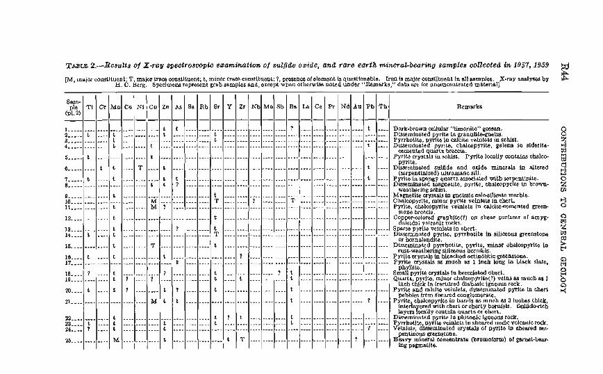
Xmm 2.-RseuZta ol X-ray spectroswla enamtnaidon of w l p & oaide, and rare earth d m a d b e a h o sumleu ooneoted la 1957, 1959
m, major comtlhenl. T mJor mua mruUtuonC L minor trace comtitllcmt: t pmnca of element Is questlombh. bca b ?naJor oowtlhont In all samples. X-my a ~ I y 8 e 8 by $ H. b. herb. Spedmelle repredn; grab samples and, exeept'wben OLhcnvlso nocad undw "Re.marks," data are for unmcenlrated material]
% Ti Cr Mn Co N1 Cu Zn Ab Be Rb 8r Y Zr IUb Mo Sb Bs La Ce h Nd Aa Pb Fh Rewb (DL 2)
1 .....................-.-..-.. t t ..........-...---............... ? -.......,........... t .... a ..... b .... t ...........- t ............ t ....-.......---..-.....-.............--..-....--..,. a ............. t ............................ t .................................................... ................................................................ 4 ............. t ........ t t ....
........................................................................ 5 ..... t ..--............ t Pyrlte crystals in sohlst. Pgrits locally conlalos ohslco- pyrite. ........................................................... 6 ......... t t .... T .... t t .... Dlsscminehd suli3de and odd6 minerals Itl altered (sorpenthizad) u l u a ~ ~ f i c sill.
7 ..... 1 .... t ............ t t ................--..............-....................... t .... Pyrlmhspngy qu~tzassoc\~ad witbw 8 ......................... t t ? ...........-.................................................... ~ l s w - m d magmute, pyrite, c~aleopyrFPh'"ib?s~n-
wealherlog sablsl. @ ........... t ............................ t .................................................... Magnetite crystslsh gnclSS10 ea1c-sUJQats marble. 10 ...................-.... M ................ T ........ ? .......- T ...............------....... Ohalcopyrlte mlnor pyrlte vclolets in chert. .................................................................... 11 ............ t ........ M. f pwita, ch~.Icb~yrlte vainlots In calcirecamentad men-
SLODB brcaa. .................................................... 12 ............ 1 .......-.................... t Go pe~.colmd grsphlte(Y) on shear soriama of amyg- &o~dal po!e@e rocks.
13 ............ t ................ ? .-...... t -.--......................-...........--...-..--.... Spwm p y ~ ~ t e velaleu In ohert. .................................................... 14 .... t ...- t ............................ T L)@mlnated pyrlre, pgrrbotite In siliceous greenstone or borablen&te. .................................................... 16 ............ t ........ T ................ t Dhcmlnated pyrrhatite, pyrlto, minor ohalcopyrite In N ~ & w M ~ ~ B M ~ slllCC!OW hor!&k.
16 .... t .... t ............ t .................... ? ............................................ P p l k u ysrals In bleached actinolitic grecnstorre. 17 ............................-... t ........-..-....-...............----......................--.... Pyrite cryst& ss muah as 1 Inch laag In blsok slats.
pbyvrc. 18 .... ? .... t ............ 7 ............ t ................ 7 t ............................ SmaU pyrIrs uyslnls in bredatad chert. 19 -........... t ? .... 1 ................ t .-.. t ............ t ............................ Q w t t , y~ltB, &nor chalcopyrlb(?) vciwns muohaa 1
Lneh $ck La Lraecqd disbaalc I eous rock. 20 .... t ..-- t ? ........ t ? ........ t .................... I ....................-....... PSrlte and calcits ve~nleLs dis4emfkted pyrlb in chert
pebbles from sheared ~ o ~ ~ ~ o m e r a w . 21 ........................ M L t ................................ t ................-... ? .... Pyrlta cbalcopyrltom bands as much m 3 kohes thick
Interbyered with cberLorcbertg bomleh. ~ a l f d ~ e 6 l a y e t s k a U y c o n t h i n W a 01 chert.
2a ............ b ............................ t ? t ............ t ..-......................... Dissemlnsted pyrite in ~ l u ~ o a l c lgnoona rock. a .... t .... t ............ t ............ t .................... L ............................ P hollte pyrl~MjnlskInshesrodm~cmlcanlcro&. ............................................................ % .... P .... t ............ t 1 .... &a, &mlnsled crystals ot pyrlta In &oatad ser-
tinous greenstwe. 26 ............ M ............ t ................ t T ................................ f ........ ZQ mineral wnmtratt, @romolm) d -l-bear.
Ing pegmstlte.
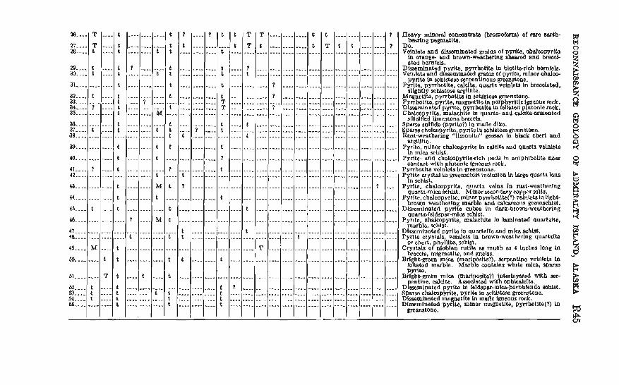
as .... ... 28 --..
b .... 20. ... at
a2 .... 33 ar .... 35
38 a7 .--. 38
29
40
41 .... 42
43
44
45 ..-. PO
47 48
49 .... 60 ........
61 ........ fQ .... 53 .&.. 54 ...- 66
....
.... ....
.... ....
....
....
....
....
....
.... t
T
....
.... ....
T
T t
t t
............ t ........-... 1 ............
............ t
...........
............ t
.........-..
........-... t
................
................ M
t t t ............
t
t :
t t
t
t L t t
L t ............................ t
t
t ................~....... t
1
t
................................
t
t
t
t t t t
t
t t
t t
t
t
t
t t t
t
t .... t
t
t
t
t
t
............................ : t f
t
....
....-...
f
L
....
........
t
t
....
....
....
7
................................................................
t
t
....................................
....-...............................
....................................
............
........... ........
........
............
............ 1 ............ ........
............ ........
..-.....
.---....
..-.........
........
............ ....
........
............
t
............ ............
T T
? t
............
............
............
t
L
t
t ................................
t
............................
t
t
...-.-..............
.... t
................
t
?
................
t t
........................................ t
t
-....... t
M
t
I
t
t
M t
M
....
t
t
t ....................................................
....................................................
....................................................
...................................................
....................................................
.........................................-..........
....................................................
....................................................
................................................ ........................................-........... .................................................... ...............................,....................
................ t
............
.... ................
....................
................
.... ............
............ ............
............
............
............
............ ?
............
............
........
.....-....-A ............ ............
t T
............................................ ............................................
............................................
............................................
............................................
........................-.-.................
........................................
r 7
....
T
L
T
.......-
7
t
t
d t
t
t T T
t t
t
1
t
t
t
t t t t
aaaw b r a l mmtmte @mmorm) ot r m earth- bearing pemlCe.
D o . , Vetalels and W m b a t e d gralas of p p i l e ~ c o w r l t o ~n orang6 ma brown-aeatberkig shssrsb and breooi- sted homfeb.
Dlssemineted ydte Pyrrbbtib b blotltbrlel, horniela. vetnletsand dpssemthated os o( pyrite, mloor abalw-
pyrite In achlstose serpen=ur greenstoae. pyrite, pynh0t~te, celc~fe, q~ertt -to ~o b r a t a w
allgbOy schlstosa argiUlte. Magnetite, pynhot la in sohlsto9e greensboe.
rite. msgoetlte la por byrlrlc Igneous rock. 3 Z k % ? ~ Y p ~ , ~ p g r r b ~ t e la p~uconlcroclc. Cbalco grlte, ma l scke In quarlz-and c u l a l ~ ~ ~ m m t e d
SIUOL& b e s t o n e brewla. Sparse sulfide (p rlla?) In mnc dlko ~ ~ n r s o e h a l a o p y r ~ pyritul'~s~hlstos~~cansto11e. Rwt-weatboring "[lmonlta" gossrrn In bbck chert w.d
81 Ulto P ~ & , n i n a chn1cc)p~~te h c d * h w d ~ u n r t n volnlet~
mlwr schist. Pyrlte- nnd cllnlca~ydlerlch pod8 h rmphlbollb mar
COntgCL wlth lutonlc llpnous W k . ~yrrhot i ta vc~~fe ts ~n manstone. P ILo crysblm greenscNst.lncI~wion In largoquartr lens
schist. Pyrlle. cb+ebp Ib, qululr vcln8 lo rust-weathsrlng
quartz-m~ca st&. Mlnor rcondar coy a r solts. P rltc.chalco yritO.mlnorDynlgtlk~)r~nlctslallght-
grown wa&erln, marble and cal-lls grmnschlst. Dlsscmlnatad pyrite cubes in dark-brown-weethering
qurn~lcldspar-mlca scMst. Pyrltc. ahalcop~T14, &Nts In lamlnatad quartzite.,
~nnrble. sc11lst. D l m l n n t o d pyrlta la q u a r t ~ l b and mica schist. Pyrila cryslds veldets in brown.wosthetlog qwhlt6
or chert h i ~ t e xhlst Crystab o?&bl& rutlli ns muah cu 4 hchas long in
braccle rnlgmstlle ond mclss. Brl h@'een mica (;narlpoalte?), sorpenttno rehlelets h
fc!oelatod marble. Marble crmtalns while mla, s ~ s n e PyrSW.
B~Ight-webn mlea mad te?) (nterlnmed mth wr- enttne de l ta . 6&d d t h opblcalelle.
Dtsernln~ted pyrite lo feldspar-rnlmhornblenda marst. S p a r s chalcopyrite pyrlle inschlstose greewtono. Dksem!mated me 'sclte lo maflc lgoeous rock. Dlasemlnated p y z , mlnor mapati@, pprrhbtlle(t) In
mmstane.
t
I
............
............
........................................................................
........................................................
....................................................................
..........................................................-.........
E46 CONTRIBGTIONB T O GENERAL QEOLOQT
The lignitic coal beds in the Hootznahoo Inlet and Murder Cum areas am thin and discontinuous and are of no comanercinl value at present (1963).
The wonomic potential of limestone and marble beds in the Pybns and Gambier Bay a m , nnd along the w w t comt of Admiralty Idand, has been evaluated by Burchnrd (1020, p. 49-56) ; to data (1962), no effort has been made to exploit these deposits.
Little is known of the structuml factors that cuntrolled the deposi- tion of met~llif erous minerals on Admirnl ty Is1 and. Twenllofel and Sainsbury (1958, p 1442) postulate that the distribution of mineral deposits, particul~rly the gold-bearing lodes, in the Juneau district is related to the position of regional faults, The results of t he present investigation neither confirm nor dnny t h i ~ thoory. At s prospect on the west side of Seymour Canal about 3 miles northwest; of Windfall Harbor, sulfide minernls seem to ba concentrated near the intersection of northrvost and northeast-trending ellcar zones, and, in mc few places on the island, F a n occur dong probnble faults. In many places, however, p a n zones nnd sulfide-bearing rocks are not assaciateci with discernible regional fnults.
Tha mineral potentinl of Admimlty Island hxs not get been fully tasted. Thick mil, glminl deposits, and dense vegetation cover much of the Rma; hence the npplicntion of gmcl~emical and geophysical ex- ploration techniques will probably be necBsary to evaluate completely its economic possibilities.
Bnndscarrd, Halfdan, FolInsbee, R E., and Lfpon, T. I., 1959, Potaasill~n-mgon arc of blotitm from Cordilleran g-r-rsnites of centml Rrltish Colmbia tabs.] : Gml. Soc. America Ball., v. 70, p. IWittl.
Bailey, D. R, Weir, J.. nnd McCallien, W. J., lm, Inhdnetion to geologg: London, Thc MacBiEUan Co, 498 p.
Barker, F r d , 11167, Geology of the Juncau IB-3) qnadrangle, Alaska: U.S. Geol. Survey Geol. Quad. Unp GQ-100, scale I: 63m.
Bern, W. C., 10R4 Three nwns of pwsible mineral m n r c e potential in m t h - eastsm Alaska : U.S. Geol, Survcy Froi. Pnper 4 0 0 4 , p. BSS-B30.
Beveriagc, A. T,, and Polinsbw, R E., Is*%, Dating Cordilleran orogenies: W a l Roc. Canada Trans., 3rd ser., v. 50, set. 4, p. 19-43.
Enddingtort, A. F., 1028, Milr5ml in~estlgation~ in mutheastern A)aska: U.S. Gcol. 8nmey Bull. 783-B. g. 4l-62.
Rutldlrl.f$on, A. F., ant1 Chapin, Theodore, 1929, Geology end mineral depmrftm of aoalheastern Blnska : U.S. Geol. Bnrvey Bull. 800,398~.
Durchurd, Iil. F., 1920, Marble resources of so~itheastern A l d a , witb a W o n on the mography and geology by Theodore Chapin: 0.8. Geol. Barney BnIl. 082,118 p.
DaU, IT. H., 1888, Report on coal and lignite of Alaska: U.S. GeoL Survey 17th Ann. m~t., pt. 1, p. 763-808.
mkln, H. M., 1918, M e mining in the Jmean gold belt : D.S, hF. Snraey Bull. 1362-B. P. 77-92.
Evefnden, J. I?., Curtis, G. H., and Lipson, J. I., 1958, Potnmlum-argon d a t a for the intmsive~ of northern and central California [aba] : -1. Soc. America Rull., v. 88, g. 1684.
Fyfe, W. S., Turner, F. J., and Verhoown, Xmn, R58, Metamorphic scactIwtr and metamorphic hcies : Geol. Soc. America Mem. 73,250 p.
Kindle, E. M., 1907, Notes on the Palmmlc faunas nnd stratigraphy of southeast ern Alaska : Jour. Geology, v. 15, p. 3144337.
Knopf, Adolph, 1911, Geology of tbe Remers Bay reglan, Alaska: 1J.8. k L Survey Bull. 448,58 p.
-1912, The Eagle River reglon, aoutb~nstcrn Alaska: 17.5. OeoL Bur~ey Bull. 502, 61 p.
Knenen, P. IT., 1833, Signlflcant featnres of graded beddlng: Am. &mot, Petrol- eum Geologists l3ull . , v. 37, p. I O W I O B B ,
l iaren. E. R., Jr., Gottirted, Dnvfd, J a f f ~ , H. W., on8 maring, C. L., 1958, Lead- alpha ages of the Iifeao7~lc hntbollths of western North America: U.S. GeoP. Survey Rnll. 107&Fk, p. XfF-82,
Latbrnm. E. EI., 1964, Appnrrnt r l~ht - ln t~rn l scpnrntion on Chatham Btrait Fault, southeastern Alnskn : Gcol. Snc. Anlcricn R1111., T. 76, g. 249-253.
Lathram, E. IE., Loncy, R. A., Berg, Il. C., nnd Pomeroy, J. S., 1940, Progem map of the geology nf Admiralty Xslnnd, Ala~kn: U.6. Geol. Survey Mise. G w l . Inv. Map 1-32?, mcnFe 1 :2X,000.
Utbrnm, E:. H., I,oncg, R. A., Condon, W. R., Berg, H. C., 1058. Progreaa map of the geolom of the Jl~nenn qnndsangle, Alnska: U.S. Geol. Survey M h . Bed. Inv. 3lnp 1-276, scale 1 :2!50.000. - 1%59, Progrcm mng of the geology o f the Janean quadrangle, Alaska : U.S. Geol, Snracg 31 isc, Grol. Xnr. hlnp X4W, male 1 :250,000.
Lomy, R, h., 1W4, S t r a t l ~ r ~ p h y ant1 petrography of thc Pyhus-Gambler Ray area, AdrnlmIb Inlnnd, Alnska : U.8. Geol. Survey Bull. 1178, 100 pp.
Loney, 11. A., Condon, W. 11.. and Dutro, J . T., Jr.. 1963, Geology of the Freah- u~ntcr Day ama, CbIchnwf Island, Alaska : U.S. Gcol. Survcp BnlL 110&[1, Ti4 P.
Martin, Q. C., 1928, The Blmmic strntigrapby of Alaska: W.S. GeoL 8urmy Bull. 774 493 p.
Martin, Lawrence, nnd Williams, F. E., 1924, An ice-eroded fiord: the mode of origin of L ~ n n Canal, Alaska : Qcog. Rcv., v. 14, p. 57F-j%.
Matzko, J. J., Jaffe, H. \I7.'., nnd maring. C. L, 1959, ,Sad-alpha age d~tcrmlna- tlons of grnnitic rocks from Alaska : A m Jonr. Sci. r. 256, p. I i 2 W 0 .
MertEe, J. B., Jr., 1921, Lode mining in the Juneau and Ketchikan dIstrlCts: U.S. Geol. Surrey Bull. 714-B, p. 10,"~1"8.
Newhe~ry, J . B., I W , Rrief descriptions of fossil plants, cbieRp Tertiarp, fmm western North Amerfcn: U.S. Katl. Blus. Prac., v. 5, g. 60w14.
Payne, T, G., 1955, hZesoroic and Cenozoic tectonic elcmcnts of Alnska : U.S. Oeol. Survey Misc. Inv. Map 1-84,
Pettijohn, F. J., 1957, Sedimentary rocks: 2d ed., New York, Harper and BFOI., 118 p.
Reed, J. C., 1942, Nickel-comr deposlt at Funter Bay, Admiraltg Island, k l ~ $ s : U.S. GeoI. Survey Bull, 9 3 W , p. 349-361.
Reed, J. G., and Coats, R. R., 1042, Geology nand ore deporrits of the Chicbagof mining district, Alaska : U.B. Qeol. Survey Bull, 920,148 g.
R& CONTRXBUTIONB TO GENERAL GEOMGY
Rommaq D. L, I W . Ueologg of the eraterP part of the Mount F.airweatber quadrangle. Qlacier Bay, Alaaka : U.B. Gml. Survey BnlL 1121-K, p. K10.
8~innsbn~, C, L, 3953, Geolom of the 01th Mountain-Clark Peak Area, Junean vicinity, Alaska : U.9. Geol. Surrey open-flle rewrt, 44 p.
SL h a n d , Plcrrc, 1DS7, Genlogicnl and geophysical 8 p t h c ~ h ot the tmtonlcs ot portions of British Columbia, the Yukon territory, find Alaska: Oeol. Sm, America Bnll., V. 68, p. 1.343-1310.
Hrnith, P. S., 1939, Areal geology of Alaska: U.S. Geo1. 8urvey Prof. Paper 192, jOO p.
Spsncer, A. O., lM!6, The Juneau gold bel& blaslia : U.S. Qeol, Bumey Bull. 281, 137 p.
Twenbafal, W. 9.. 1962, Recent mhoreline cbangea along the Paclfic cocoast of N a ~ k a : Am. Sour. Sci., v. 2E0, no. 7, p. -13.
-ID&& Geology of the AIaska-Jnneau Iode sy~tem, Alaska: U.B. Qeol. Rurvey open-file report. 175 p.
Twenhobcl, W. S., Rmd, J. C., and Oatea. G. O., 1949. Some mlneral investiga- tions itl southeastern Alaska : U.B. Oeol, Rncvey Ball. -A, p. 1-45.
Twenhofel, \V. S., and Sainsbury, C. L., fSriFI, Fanlt p a t t m in mnthearrtern Alaaka : Geol. Soc. America Bull., v. 69, p. 1431-1442.
U-IT. Weathem Burean, 1959, CIlrnates of Ibe Statm-Alaska: CUmatographg US., no. 6 0 4 4 2 4 p.
West, W. S, and Benson, P. D., 1DM, Investlgatfons for radioactive depDaite In southeastern Alaska : U,S. Oeol. Survey Bull. 3024-B, p. 25-57.
WheeIer, 8. E., 1939, Permian rolcanhm in weatern North Amerlca : Btb Pacific Sd. Cong. Proc., p 3fW37R.
Williams, RoweI, Turner, F. J., and Gilbert, C. M., 1954, Petrography-an intm duction to the stnclp of rocks in thin # d o n s : Ban Francisco, CalU., W. H. Freeman and Go., 406 p 1 reprinted. 19381.
Wright, C. W., 1008, A remnnnissanm of Admiralty Inland, Alaska: U.S. Beol. Gurney Bull. 287, p. 13R-m.