Embed Size (px)
Citation preview
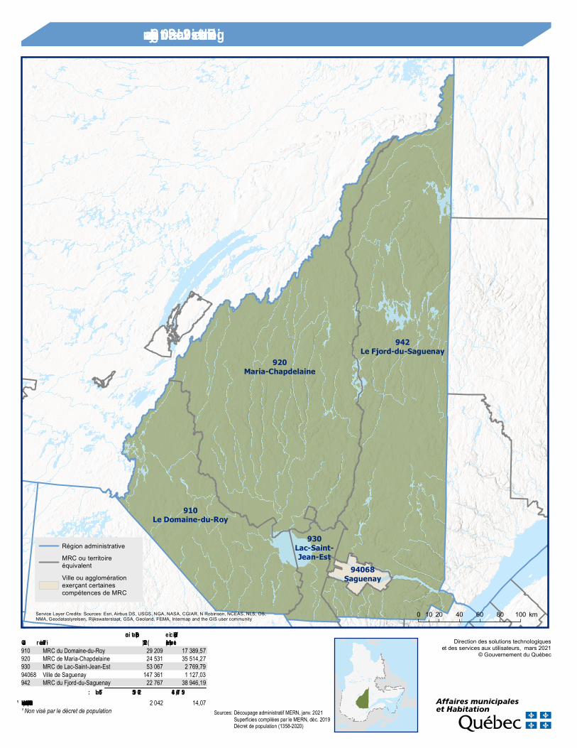
920Maria-Chapdelaine
942Le Fjord-du-Saguenay
910Le Domaine-du-Roy
930Lac-Saint-Jean-Est
94068Saguenay
Direction des solutions technologiqueset des services aux utilisateurs, mars 2021
© Gouvernement du Québec
0 20 40 60 80 10010 km
Région administrative 02 : Saguenay –Lac-Saint-Jean
Région administrativeMRC ou territoireéquivalentVille ou agglomérationexerçant certainescompétences de MRC
Service Layer Credits: Sources: Esri, Airbus DS, USGS, NGA, NASA, CGIAR, N Robinson, NCEAS, NLS, OS,NMA, Geodatastyrelsen, Rijkswaterstaat, GSA, Geoland, FEMA, Intermap and the GIS user community
Code Territoire (2021)Population
terrestre (km²)Superficie
910 MRC du Domaine-du-Roy 29 209 17 389,57920 MRC de Maria-Chapdelaine 24 531 35 514,27930 MRC de Lac-Saint-Jean-Est 53 067 2 769,7994068 Ville de Saguenay 147 361 1 127,03942 MRC du Fjord-du-Saguenay 22 767 38 946,19
Total : 276 935 95 746,84Hors MRC (communauté autoch tone) ¹ 2 042 14,07¹ Non visé par le décret de population Sources: Découpage administratif MERN, janv. 2021
Superficies compilées par le MERN, déc. 2019Décret de population (1358-2020)
169
169
167
155
70
Lac-Ashuapmushuan, NO
La Doré, PSaint-
Félicien, V
Saint-Prime, M Mashteuiatsh, R
Roberval, V
Sainte-Hedwidge, M Chambord, M
Saint-François-
de-Sales, MSaint-André-du-Lac-Saint-
Jean, VL
Lac-Bouchette, M
Lac-Ashuapmushuan, NO
La Doré, PSaint-Félicien, VSaint-Prime, M
Mashteuiatsh, RSainte-
Hedwidge, MSaint-André-du-Lac-Saint-
Jean, VLLac-
Bouchette, M
0 10 20 305 km
Direction des solutions technologiqueset des services aux utilisateurs, mars 2021
© Gouvernement du Québec
Population par municipalité(décret 2021)
0 - 1 999 h.2 000 h. - 9 999 h.10 000 h. - 49 999 h.
Limites administrativesRégion administrativeMRC
Réseau routierAutorouteRoute nationaleRoute régionale
Service Layer Credits: Sources: Esri, Airbus DS, USGS, NGA, NASA, CGIAR, N Robinson, NCEAS, NLS, OS,NMA, Geodatastyrelsen, Rijkswaterstaat, GSA, Geoland, FEMA, Intermap and the GIS user community
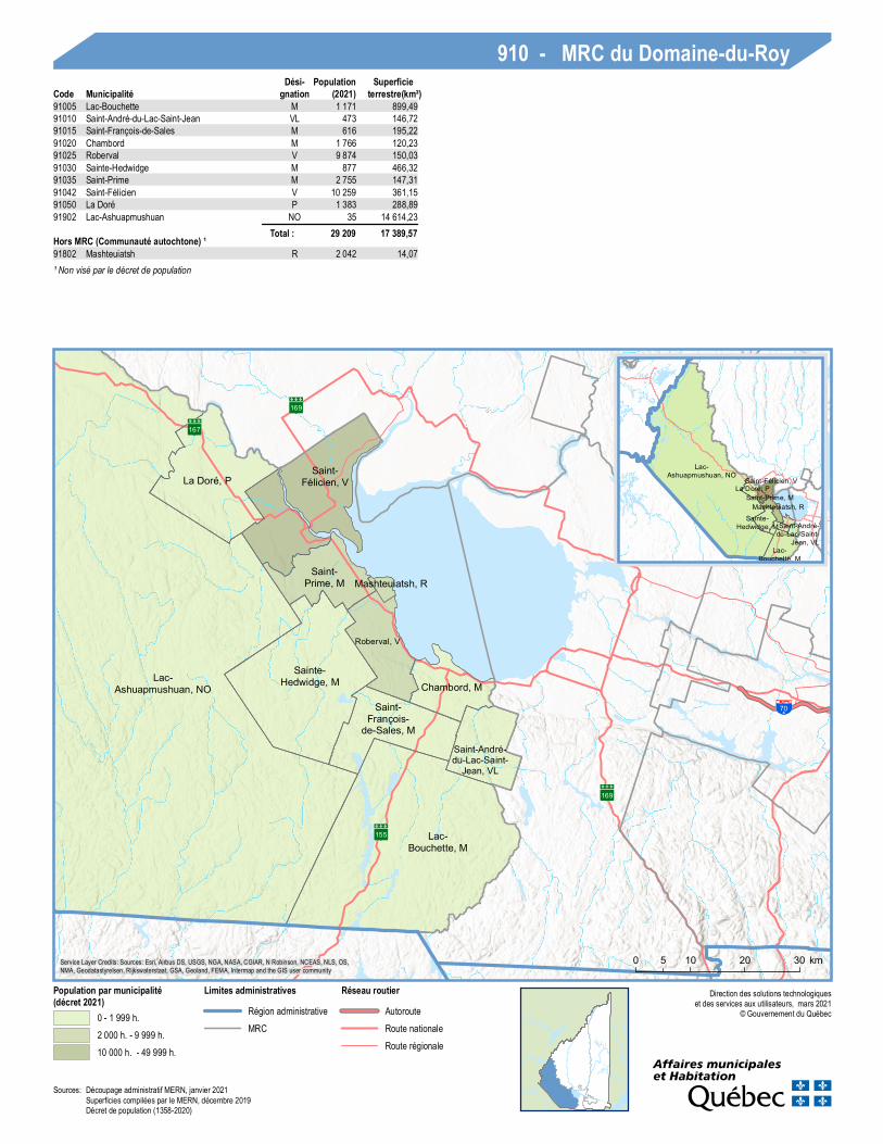
910 - MRC du Domaine-du-RoyCode Municipalité
Dési-gnation (2021)
Populationterrestre(km²)
Superficie
91005 Lac-Bouchette M 1 171 899,4991010 Saint-André-du-Lac-Saint-Jean VL 473 146,7291015 Saint-François-de-Sales M 616 195,2291020 Chambord M 1 766 120,2391025 Roberval V 9 874 150,0391030 Sainte-Hedwidge M 877 466,3291035 Saint-Prime M 2 755 147,3191042 Saint-Félicien V 10 259 361,1591050 La Doré P 1 383 288,8991902 Lac-Ashuapmushuan NO 35 14 614,23
Total : 29 209 17 389,57Hors MRC (Communauté autochtone) ¹91802 Mashteuiatsh R 2 042 14,07¹ Non visé par le décret de population
Sources: Découpage administratif MERN, janvier 2021Superficies compilées par le MERN, décembre 2019Décret de population (1358-2020)
169167
Passes-Dangereuses, NO
Rivière-Mistassini, NO
Notre-Dame-de-Lorette, M
Girardville, MSaint-
Stanislas, M
Saint-Thomas-
Didyme, M
Saint-Eugène-
d'Argentenay, MSaint-Edmond-les-Plaines, M
Sainte-Jeanne-d'Arc, VL
Dolbeau-Mistassini, V
Albanel, M
Normandin, V Saint-Augustin, P
Péribonka, M
Passes-Dangereuses, NO
Rivière-Mistassini, NO
Notre-Dame-de-Lorette, MSaint-Eugène-
d'Argentenay, MNormandin, V
0 10 20 30 405 km
Direction des solutions technologiqueset des services aux utilisateurs, mars 2021
© Gouvernement du Québec
Population par municipalité(décret 2021)
0 - 1 999 h.2 000 h. - 9 999 h.10 000 h. - 49 999 h.
Limites administrativesMRC
Réseau routierRoute nationaleRoute régionale
Service Layer Credits: Sources: Esri, Airbus DS, USGS, NGA, NASA, CGIAR, N Robinson, NCEAS, NLS, OS,NMA, Geodatastyrelsen, Rijkswaterstaat, GSA, Geoland, FEMA, Intermap and the GIS user community
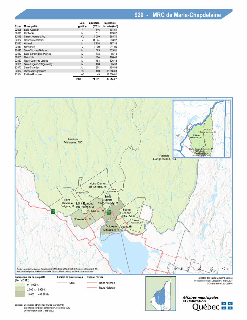
920 - MRC de Maria-ChapdelaineCode Municipalité
Dési-gnation (2021)
Populationterrestre(km²)
Superficie
92005 Saint-Augustin P 346 104,6192010 Péribonka M 511 109,8292015 Sainte-Jeanne-d'Arc VL 1 059 268,7092022 Dolbeau-Mistassini V 14 024 293,9792030 Albanel M 2 258 197,1692040 Normandin V 3 029 211,9692045 Saint-Thomas-Didyme M 669 339,0192050 Saint-Edmond-les-Plaines M 378 85,1592055 Girardville M 994 126,4692060 Notre-Dame-de-Lorette M 183 326,4892065 Saint-Eugène-d'Argentenay M 468 85,3392070 Saint-Stanislas M 374 158,9992902 Passes-Dangereuses NO 189 15 556,6392904 Rivière-Mistassini NO 49 17 650,01
Total : 24 531 35 514,27
Sources: Découpage administratif MERN, janvier 2021Superficies compilées par le MERN, décembre 2019Décret de population (1358-2020)
169
169
155
70
Saint-Ludger-de-
Milot, M
Lamarche, M
Sainte-Monique, M
L'Ascension-de-Notre-
Seigneur, P Labrecque, MSaint-Henri-de-Taillon, M
Alma, V
Saint-Nazaire, M
Saint-Gédéon, M Saint-
Bruno, M
Métabetchouan- Lac-
à-la-Croix, V
Hébertville-Station, VLDesbiens, V
Belle-Rivière, NO
Lac-Achouakan, NO
Lac-Moncouche, NO Mont-
Apica, NO
Hébertville, M
0 10 20 305 km
Direc tion des solutions tec h nolog iqueset des services a ux utilisa teurs, m a rs 2021
© Gouvernement du Québec
Population par municipalité(décret 2021)
0 - 1 999 h.2 000 h. - 9 999 h.10 000 h . - 49 999 h.
Limites administrativesRégion a dministra tiveMRC
Réseau routierAutorouteRoute na tiona leRoute régiona le
Service La yer Credits: Sources: Esri, Airb us DS, USGS, NGA, NASA, CGIAR, N Rob inson, NCEAS, NLS, OS,NMA, Geoda ta styrelsen, Rijkswa tersta a t, GSA, Geola nd, FEMA, Interm a p a nd th e GIS user com m unity
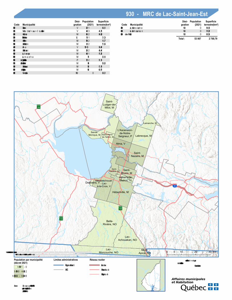
930 - MRC de Lac-Saint-Jean-EstCode Municipalité
Dési-gnation (2021)
Populationterrestre(km²)
SuperficieCode Municipalité
Dési-gnation (2021)
Populationterrestre(km²)
Superficie
93005 Desbiens V 1 002 10,6593012 Méta betc h oua n–La c-à-la -Croix V 3 904 187,4493020 Hébertville M 2 566 260,4993025 Hébertville-Sta tion VL 1 311 33,1393030 Sa int-Bruno M 2 895 77,5193035 Sa int-Gédéon M 2 201 63,1593042 Alm a V 30 915 194,9593045 Sa int-Na za ire M 2 062 144,8493055 La b recque M 1 346 152,1593060 La m a rc h e M 471 81,2593065 L'Ascension-de-Notre-Seig neur P 2 027 131,1993070 Sa int-Henri-de-Ta illon M 881 62,5093075 Sa inte-Monique M 867 151,1093080 Sa int-Ludger-de-Milot M 619 107,0693902 Mont-Apic a NO 0 12,63
93904 La c-Monc ouc h e NO 0 251,9993906 La c-Ac h oua ka n NO 0 233,9793908 Belle-Rivière NO 0 613,80
Total : 53 067 2 769,79
Sources:Découpa ge a dministra tif MERN, ja nvier 2021Superficies com pilées pa r le MERN, décem b re 2019Décret de popula tion (1358-2020)
170
175
170
175
172
17070
Saguenay, V
0 105 km
Direction des solutions technologiqueset des services aux utilisateurs, mars 2021
© Gouvernement du Québec
Population par municipalité (décret2021)
100 000 h. - 2 000 000 h.
Limites administrativesMRC
Réseau routierAutorouteRoute nationaleRoute régionale
Service Layer Credits: Sources: Esri, Airbus DS, USGS, NGA, NASA, CGIAR, N Robinson, NCEAS, NLS, OS,NMA, Geodatastyrelsen, Rijkswaterstaat, GSA, Geoland, FEMA, Intermap and the GIS user community
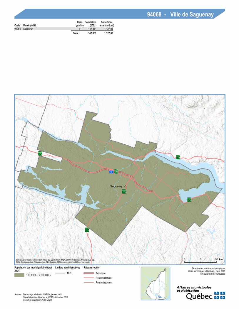
94068 - Ville de SaguenayCode Municipalité
Dési-gnation (2021)
Populationterrestre(km²)
Superficie
94068 Saguenay V 147 361 1 127,03 Total : 147 361 1 127,03
Sources: Découpage administratif MERN, janvier 2021Superficies compilées par le MERN, décembre 2019Décret de population (1358-2020)
170
169
17270
Bégin, M
Saint-David-de-Falardeau, M
Saint-Ambroise, M
Saint-Charles-de-Bourget, M
Sainte-Rose-du-Nord, P
Saint-Félix-d'Otis, M
Rivière-Éternité, M
L'Anse-Saint-
Jean, M
Petit-Saguenay, M
Lalemant, NO
Mont-Valin, NO
Saint-Honoré, V
Saint-Fulgence, M
Larouche, M
Lac-Ministuk, NO Ferland-et-
Boilleau, M
Saint-Charles-de-Bourget, M Sainte-
Rose-du-Nord, PPetit-Saguenay, M
Mont-Valin, NO
0 10 20 30 405 km
Direction des solutions technologiqueset des services aux utilisateurs, mars 2021
© Gouvernement du Québec
Population par municipalité(décret 2021)
0 - 1 999 h.2 000 h. - 9 999 h.
Limites administrativesRégion administrativeMRC
Réseau routierAutorouteRoute nationaleRoute régionale
Service Layer Credits: Sources: Esri, Airbus DS, USGS, NGA, NASA, CGIAR, N Robinson, NCEAS, NLS, OS,NMA, Geodatastyrelsen, Rijkswaterstaat, GSA, Geoland, FEMA, Intermap and the GIS user community
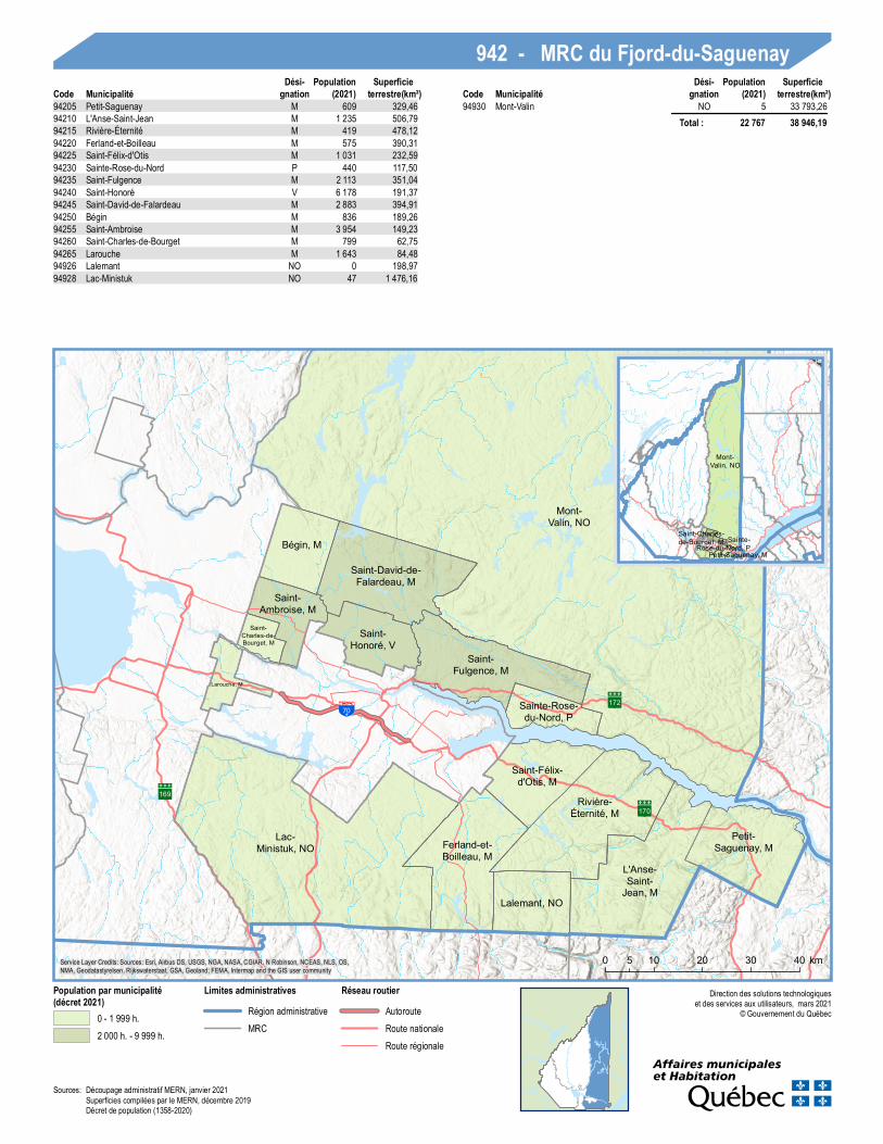
942 - MRC du Fjord-du-SaguenayCode Municipalité
Dési-gnation (2021)
Populationterrestre(km²)
SuperficieCode Municipalité
Dési-gnation (2021)
Populationterrestre(km²)
Superficie
94205 Petit-Saguenay M 609 329,4694210 L'Anse-Saint-Jean M 1 235 506,7994215 Rivière-Éternité M 419 478,1294220 Ferland-et-Boilleau M 575 390,3194225 Saint-Félix-d'Otis M 1 031 232,5994230 Sainte-Rose-du-Nord P 440 117,5094235 Saint-Fulgence M 2 113 351,0494240 Saint-Honoré V 6 178 191,3794245 Saint-David-de-Falardeau M 2 883 394,9194250 Bégin M 836 189,2694255 Saint-Ambroise M 3 954 149,2394260 Saint-Charles-de-Bourget M 799 62,7594265 Larouche M 1 643 84,4894926 Lalemant NO 0 198,9794928 Lac-Ministuk NO 47 1 476,16
94930 Mont-Valin NO 5 33 793,26 Total : 22 767 38 946,19
Sources: Découpage administratif MERN, janvier 2021Superficies compilées par le MERN, décembre 2019Décret de population (1358-2020)