Embed Size (px)
Citation preview
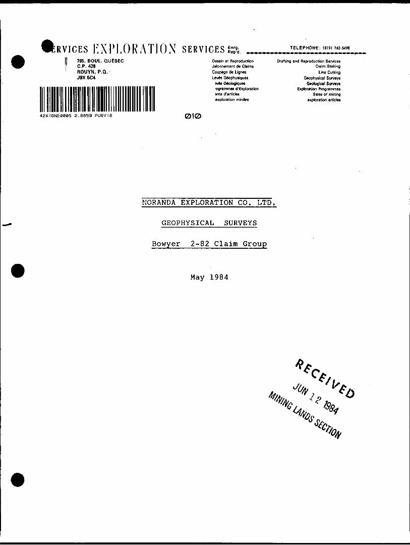
•RVICES EXPLORATION SERVICES765. BOUL. QUEBEC C.P. 428 ROUYN, P.O. J9X 5C4
42A16NE0005 2 .6859 PURVIS 010
Oessin et Reproduction Jalonnement de Claims Coupage de Lignes Leves Geophysiques
ives Geologiquesogrammes d'Exploratkm me d'erticlesexploration miniere
TELEPHONE: (819) 762-5498
Drafting and Reproduction ServicesClaim Staking
Line CuttingGeophysical Surveys
Geological SurveysExploration Programmes
Sales of miningexploration articles
NORANDA EXPLORATION CO. LTD.
GEOPHYSICAL SURVEYS
Bowyer 2-82 Claim Group
May 1984
- l -
I - INTRODUCTION: Geophysical surveys were carried out during the month
of March, 1984, on the BOWYER 2-82 claim group of NORANDA EXPLORATION CO. LTD. in order to evaluate the INPUT anomalies thereon located.
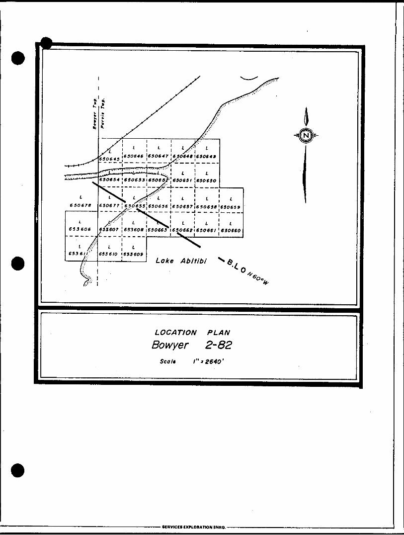
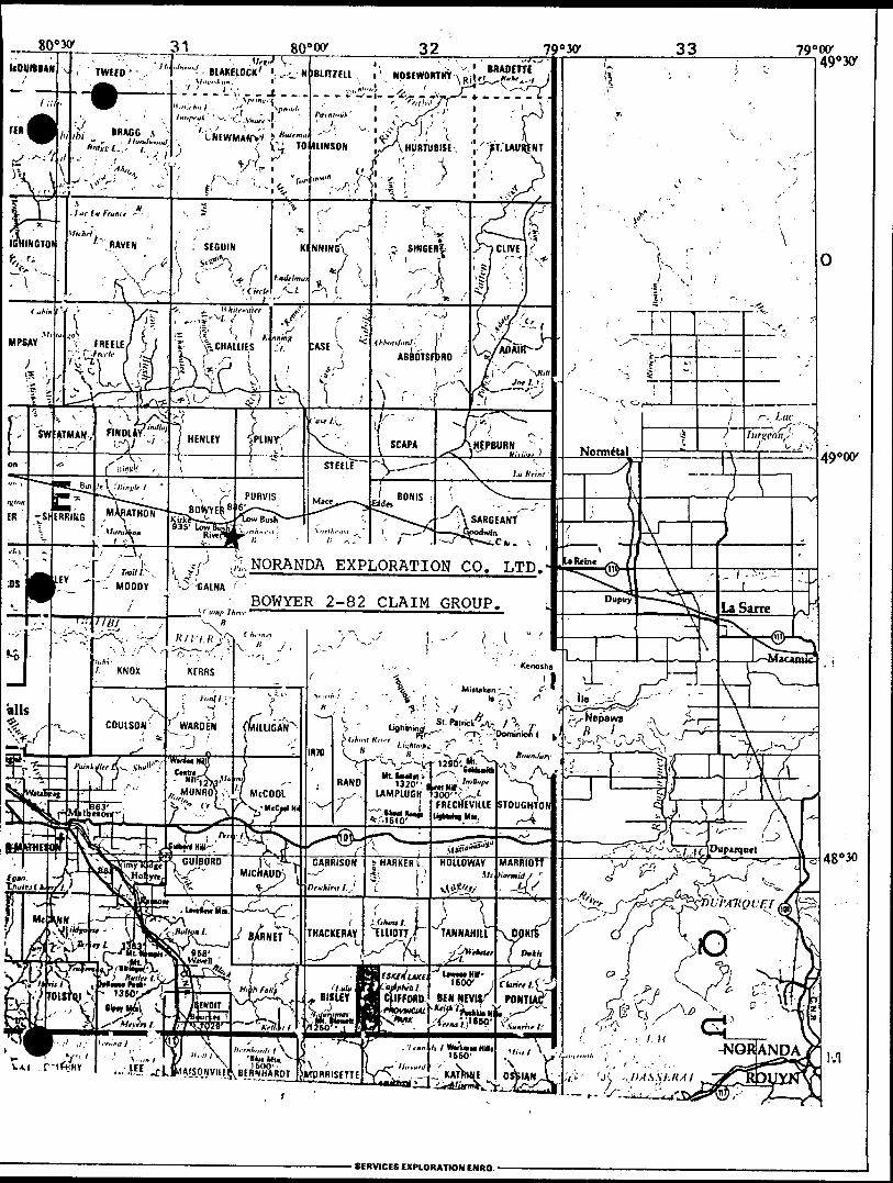
II - PROPERTY The property consists of 26 contiguous forty acre
claims located in Bowyer and Purvis Twps, Ontario. The 1984 surveys covered the following claims only:
650654, 650655, 650656, 650663, 650677, 650678,
653606, 653607, 653608, 653609, 653610, 653611.
Ill - LOCATION A ACCESSIBILITY:
The property is located partly in the southeast
corner of Bowyer Twp. and partly in the southwest quadrant of Purvis Twp., in the extreme northwestern
area of Lake Abitibi.
The area may be reached by railroad: the Senneterre- Cochrane Canadian National line traverses the north
western part of the claim group. The area may also be reached by boat from various convenient points
along the shores of Lake Abitibi.
- 2 -
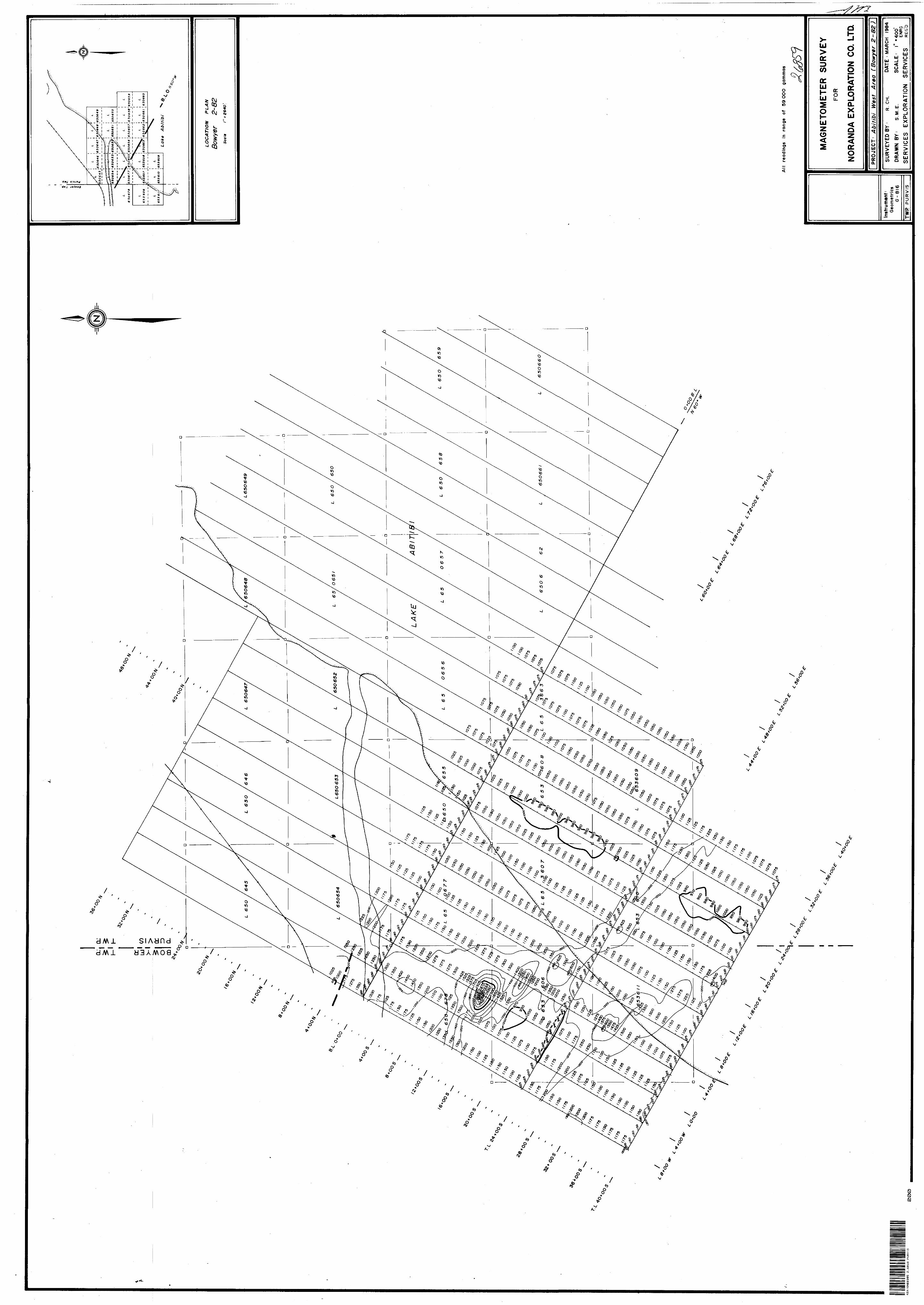
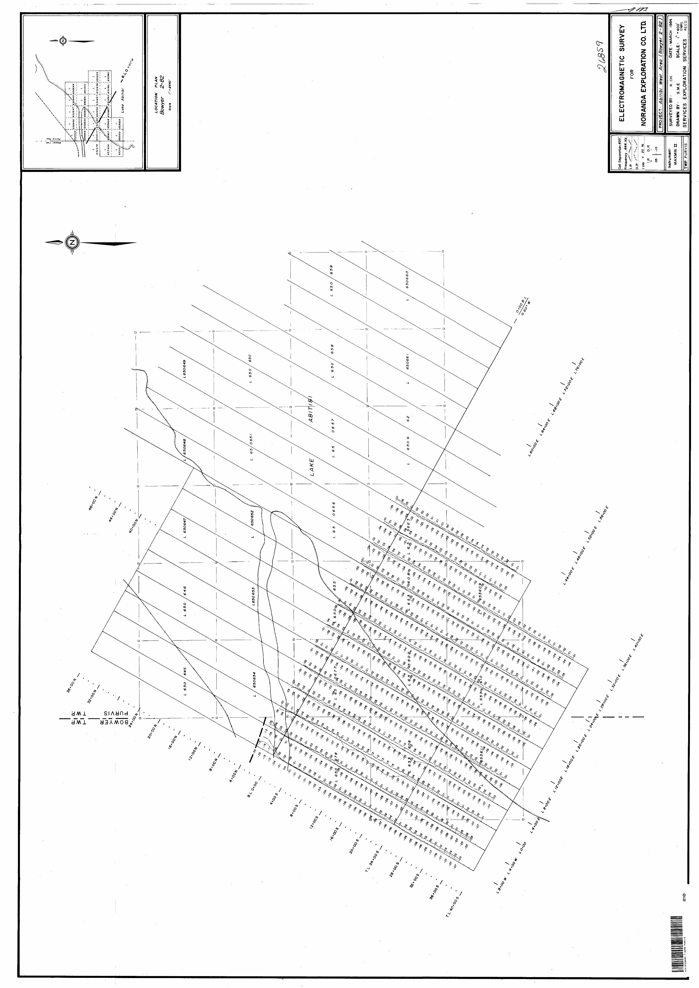
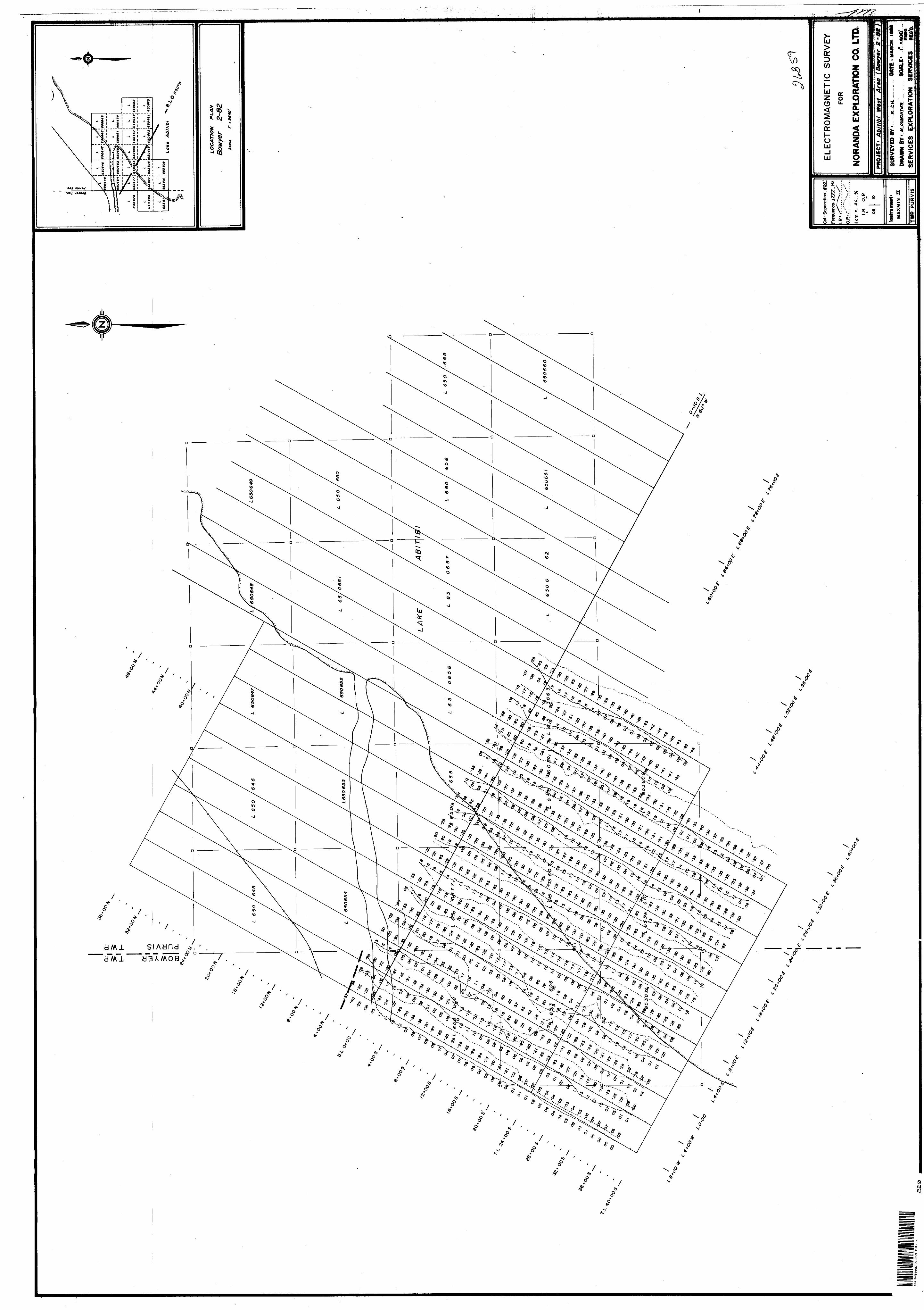
III - GEOPHYSICAL SURVEYS:
The surveys were carried out on a previously cut grid whose 8,400' long base line strikes at ISO 0 ; cross lines occur at every 400' intervals. The survey covered lines 8W to 32E from 6+OON to 40+OOS and cross line 36E and 40E from 6+OON to 24+OOS.
A total of 12.7 line miles of magnetometer survey and 10.5 line miles of electromagnetic survey have thus been completed.
Magnetometer Survey;
A McPhar M-700 fluxgate magnetometer was used for the survey, readings were taken at evey 100' intervals normally and at every 50' intervals over anomalous
areas.
Irregular magnetic patterns were observed in the western part of the grid: the strongest magnetic anomaly observed is centered at 14+OOS on cross line O-f-00; it lies within a narrow magnetic corridor of weaker magnetic expression within 1 the 1200 gamma range of contour lines. This corridor trending in a southeast direction probably indicates the presence of a diabase dyke.
Another magnetic anomaly has been outlined in the vicinity of 29+OOS on cross line 4E. It also lies within a broader pattern outlined by the 1200 magnetic contour line. The presence of another diabase dyke trending in a southeast direction is also inferred.
- SERVICES EXPLORATION ENRO.
- 3 -
Electromagnetic Survey;
An Apex Parametrics Maxmin II horizontal loop unit
was used for the survey with a 600' coil seperation.
Readings were taken at every 100' intervals on the
444 and 1777 Hz. frequencies.
Only one anomaly has been partially outlined by the
survey; it is located on cross line 8W and 4W where
the conductor axis appears to be centered in the
vicinity of 4N. This anomaly has probably been
outlined by previous surveys. This electromagnetic
anomaly is not associated with a magnetic response.
V - CONCLUSIONS Si RECOMMENDATIONS;
To complete the evaluation of this particular area
an induced polarization survey should be carried out.
Even though the electromagnetic survey has failed to
identify a geophysical target, an induced polarization
survey may be able to do so.
Respectfully submitted:
E. Chartre: L^/'/^~~~~~~^_______ May 15,1984
- SERVICES EXPLORATION ENRO.'
653608 \650663 \65066ti6S066l
Oo.
LOCATION PLAN
Bowyer 2-82Scale l"* 2640'
- SERVICES EXPLORATION ENRO. -
790 00'
BlAKElOCK'', ' H
l.v.'J
,^,NORANDA EXPLORATION CO. LTD.s5 WNA f
A
- SERVICES EXPLORATION ENRO
File.
42A16NE0005 2 .6859 PURVIS 900
Ontario
TO BE ATTACHED AS AN APPENDIX TO TECHNICAL REPORTFACTS SHOWN HERE NEED NOT BE REPEATED IN REPORT
TECHNICAL REPORT MUST CONTAIN INTERPRETATION, CONCLUSIONS ETC.
Type of Survey (s). Township or Area. Claim Holder(s)_
GROUND MAGNETOMETER AND H.E.M.
BOWYER AND PURVIS TWPS
NORANDA EXPLORATION CO.LTD.
Survey Company SERVICES EXPLORATION, NORANDA QUEBEC
Author of Report E. CHARTRE_______L———————Address of Author 765 BOUL. QUEBEC, NORANDA , Q IIEBEQ
Covering Dates of Survey 10/03/84 to 16/03/84(linecutting to office)
7 miles__________Total Miles of Line Cut.
SPECIAL PROVISIONS CREDITS REQUESTED
ENTER 40 days (includes line cutting) for first survey.ENTER 20 days for each additional survey using same grid.
Geophysical—Electromagnetic—22.—Magnetometer——12,—Radiometric—————Other———————
DAYSper claim
Geological.Geochemical.
AIRBORNE CREDITS (Special provision crediti do not apply to airborne surveys)
Magnetometer. .Electromagnetic. . Radiometric(enter days per claim)
Res. Geol.. .Qualifications.Previous Surveys
File No. Type Date Claim Holder
•:
MINING CLAIMS TRAVERSED List numerically
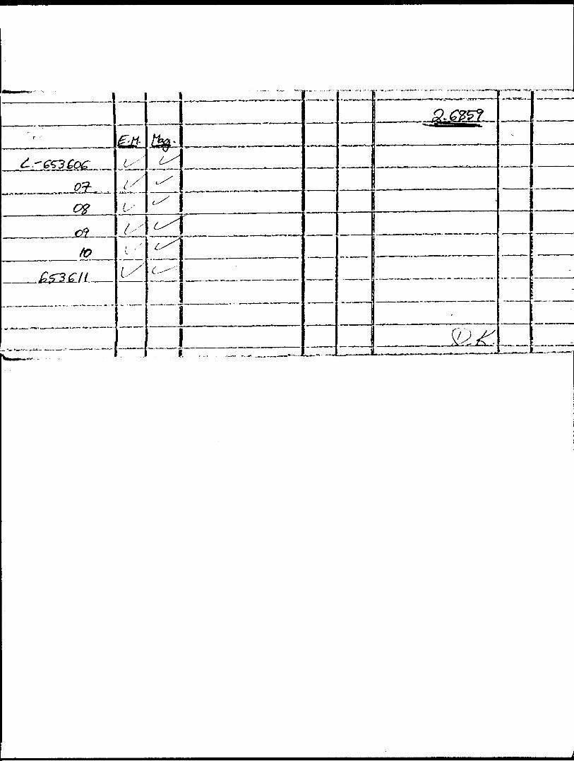
L - 653606"""(prefix)""""
L - 653607(number)
L - 653608
L - 653609
L - 653610
L - 653611
..............Vjd
TOTAL CLAIMS.
837 (6/79)
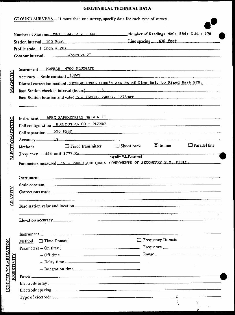
GEOPHYSICAL TECHNICAL DATA
GROUND SURVEYS — If more than one survey, specify data for each type of survey
Number of Statinnc MAC?; 5B4; K.M.; 48R
Station interval 100 Feet—,^^....^—. Profile scale _3
.Number of Readings MAG; 584; E.M.
.Line sparing 400 feet——————
Contour interval.7~
Instrument McPHAR M700 FLUXGATE
Accuracy — Scale constant.Diurnal correction method PROPORTIONAL CORR'N AsA Fn of Time Rel. to Fixed Base STN.
LJsBase Station check-in interval (hours)Base Station location and value L - 1600E f 24QOS r 1275
i gInstrument APEX PARAMETRICS t^AXMIN II
Coil configuration HORIZONTAL CO - PLANAR
Coil separation 6QO FEET-—————.^——
Accuracy ——— l%
CD Fixed transmitter
444 and 1777 Hz_________
D Shoot back l In lineMethod:Frequency. ^^
^ (ipecifyV.L. F. nation)
Parameters measured T N - PHASE AND QUAD. COMPONENTS OF SECONDARY E.M. FIELD.
D Parallel line
O
Instrument.Scale constant.
Corrections made.
Base station value and location
Elevation accuracy.
INDUCED POLARIZATION
Method D Time Domain
Parameters — fin time
H Off timet! > — PHay timeH c/1 — Integration timeC/3W Power
Electrode arrayElectrode soacine . — . ... ———————
D Frequency Domain
FrequencyRange
————————————————————————————————————————— (
Type of electrode
SELF POTENTIAL
Instrument——————————————————————————————————————— Range. Survey Method ———————————————————————————————————————————
Corrections made.
RADIOMETRIC
Instrument ———.Values measured.Energy windows (levels).^——————————————————————.———^^Height of instrument____________________________Background Count,
Size of detector—-——————-^^—^———————.^^—^—^^^—^—™.——————
Overburden ^.———----——.—.-———--——.-..—^..-........,.—.—.—..—.——.——-——(type, depth - include outcrop map)
OTHERS (SEISMIC, DRILL WELL LOGGING ETC.)
e of survey.^———————————^^————^— Instrument ^———————————^^^——————Accuracy—^^——--————————^————————Parameters measured.
Additional information (for understanding results).
AIRBORNE SURVEYS
Type of survey(s) ———
Instrument(s) —————(specify for each type of lurvey)
Accuracy^——————————————(specify for each type of survey)
Aircraft used.—————.^——————-—-—-———.————^—^—
Sensor altitude.Navigation and flight path recovery method.
Aircraft altitude______________________________Line Sparing
Miles flown over total area________________________Over claims only.
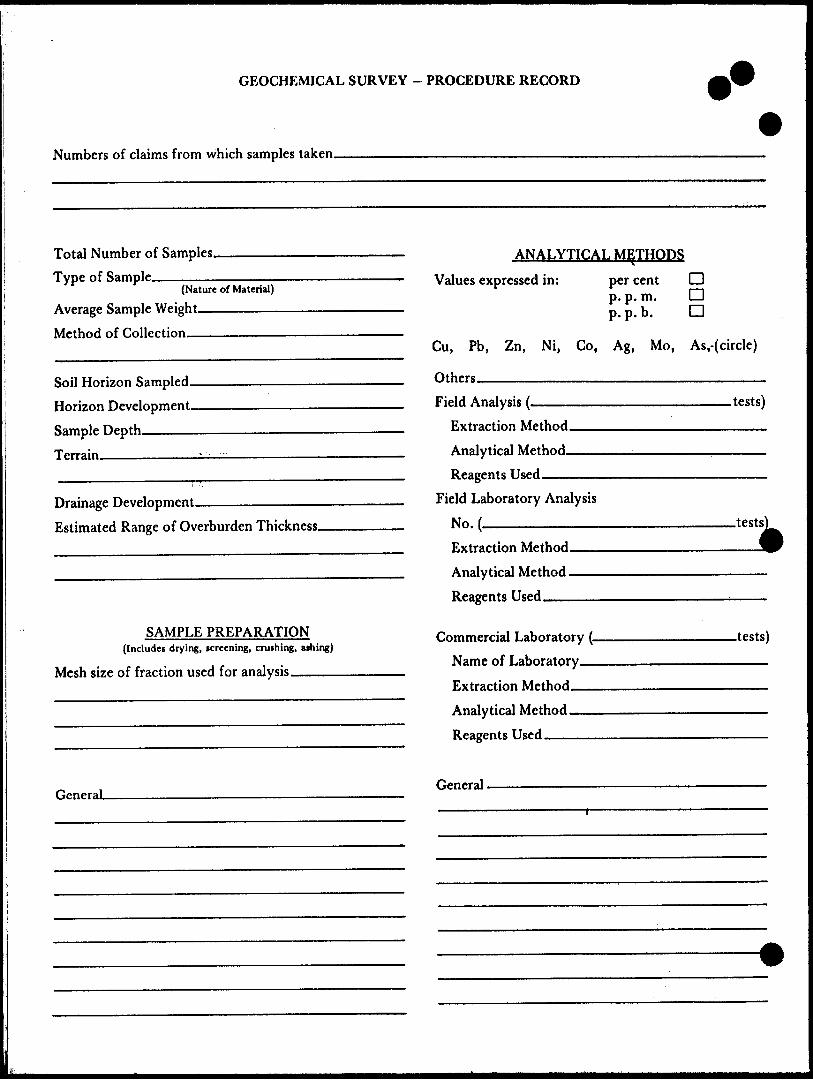
GEOCHEMICAL SURVEY - PROCEDURE RECORD
Numbers of claims from which samples taken.
Total Number of Samples. Type of Sample.
(Nature of Material)
Average Sample Weight———————
Method of Collection————————
Soil Horizon Sampled. Horizon Development.
Sample Depth————
Terrain————————.
Drainage Development———————————
Estimated Range of Overburden Thickness.
ANALYTICAL METHODS
Values expressed in: per centp. p. m. p. p. b.
D D D
Cu, Pb, Zn, Ni, Co, Ag, Mo, As.-(circle)
Others .__________________________Field Analysis (.
Extraction Method.
Analytical Method- Reagents Used——
Field Laboratory Analysis
No. ^————————
SAMPLE PREPARATION(Includes drying, screening, crushing, ashing)
Mesh size of fraction used for analysis————
Extraction Method. Analytical Method .
Reagents Used-——
Commercial Laboratory (- Name of Laboratory^.
Extraction Method^—
Analytical Method—— Reagents Used ——^—
.tests)
.tests)
-tests)
GeneraL General.
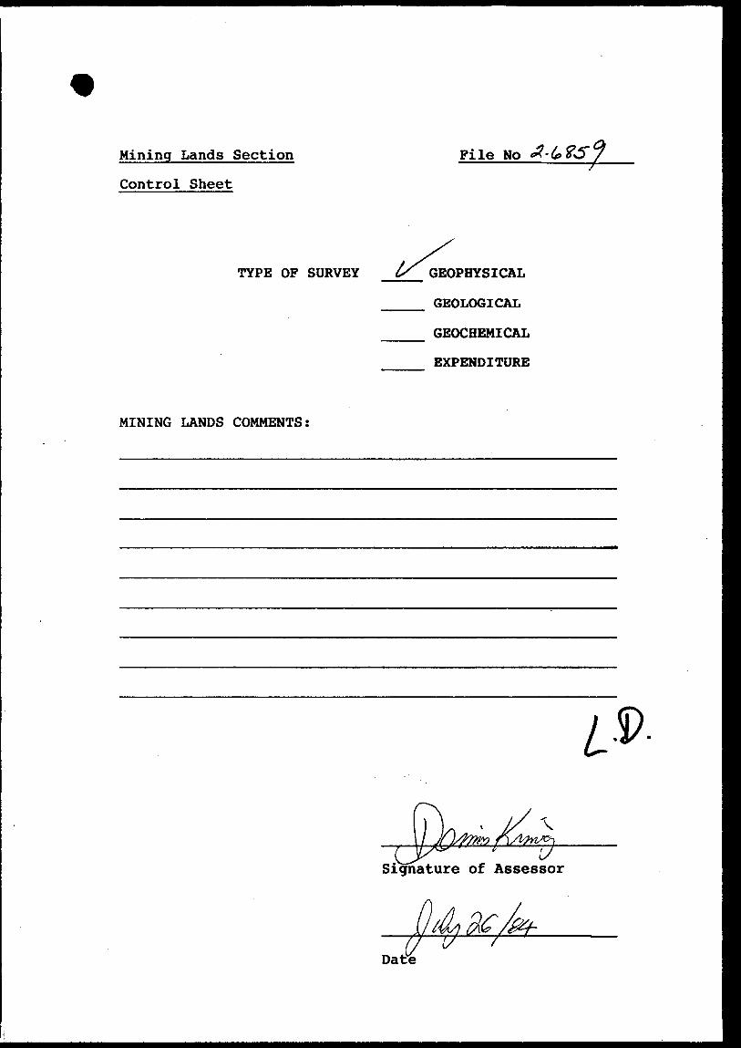
Mining Lands Section
Control Sheet
File No
TYPE OF SURVEY GEOPHYSICAL
GEOLOGICAL
GEOCHEMICAL
EXPENDITURE
MINING LANDS COMMENTS:
Signature of Assessor
O
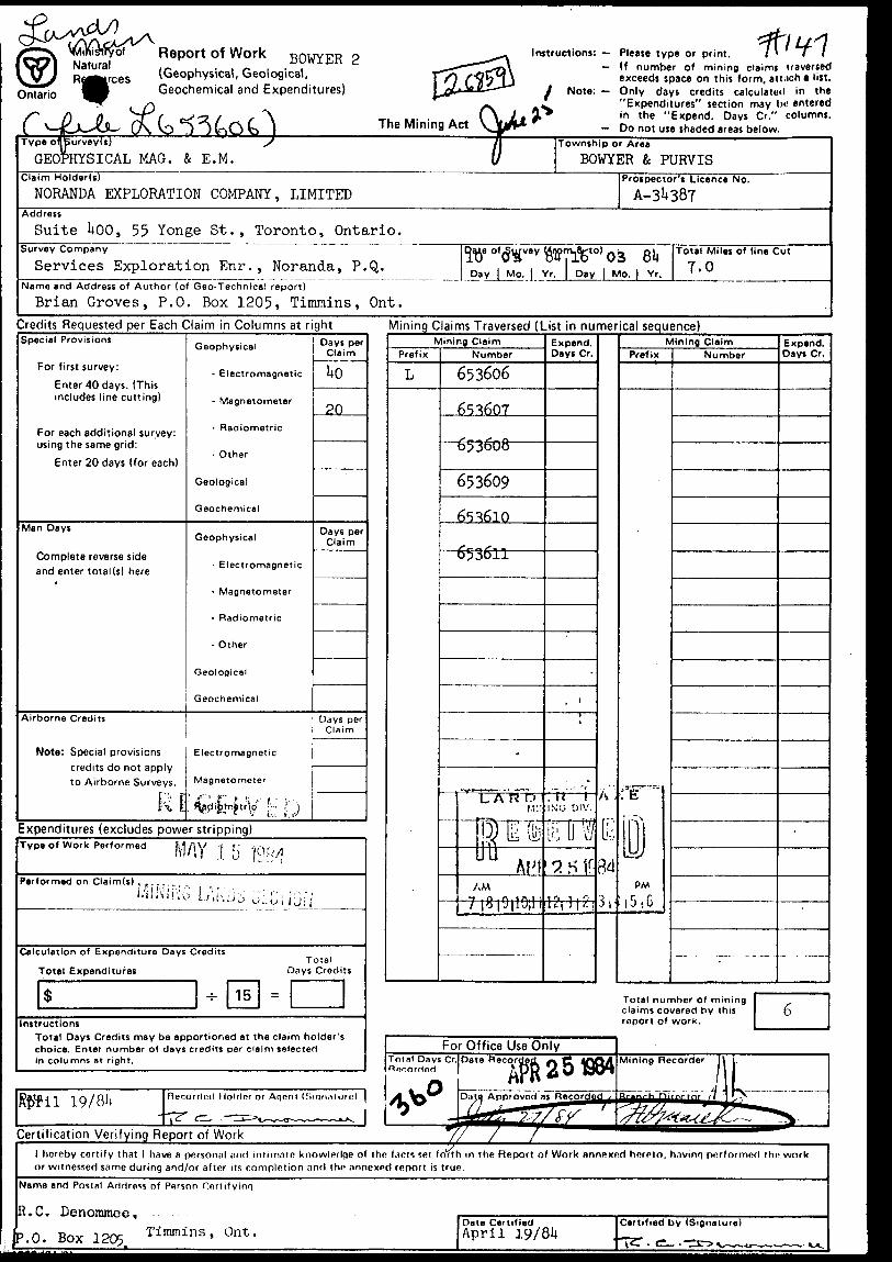
® \MiKi3tryof Report Of Work BOWYER ? ^^-\ Instructions: - Please type or print. l * l l Natural ,- , . . ^ . . V ^-~~~~~^r\ — " number of mining claims traversed R^^rces (Geophysical, Geological, f^ fflblJ exceeds space on this form, ati.ich a list.
Ontario ^V Geochemical and Expenditures) Lc^"-^"" "^ f Note: — Only days credits calculated in the ^^f r\ -^ ^ "Expenditures" section may he entered
S* fi ft JT C cS'ZL l f ~\ t.- - (\ i t r i n t he "Expend. Days Cr." columns. C ^-JKLX-^LSL, 0\ VD ; J C-iO t) ) The Mining Act \_jjy** - Do not use shaded areas below.Type of)Burvey(s) s
GEOPHYSICAL MAG. fc E. M./j Tow
v ]Claim Holder(s)
NORANDA EXPLORATION COMPANY, LIMITEDAddress
Suite 1*00, 55 Yonge St., Toronto, Ontario.Survey Company
Services Exploration Enr. , Noranda, P. Q.Name and Address of Author (of Geo-Technical report)
Brian Groves, P.O. Box 1205, Timmins, Ont.
iship or Area
BOWYER ft PURVISProspector's Licence No.
Dale of .Survey Mnom.( TD O3 W 11
Day | Mo. | Yr. D
5tol OS 81*ay | Mo. | Yr.
Total Miles of line Cut
7.0
Credits Requested per Each Claim in Columns at rightSpecial Provisions
For first survey:Enter 40 days. (This includes line cutting)
For each additional survey: using the same grid:
Enter 20 days (for each)
Man Days
Complete reverse side and enter total(s) here
Airborne Credits
Note: Special provisions credits do not apply to Airborne Surveys.
RI
Geophysical
- Electromagnetic
- Magnetometer
- Radiometric
- Other
Geological
Geochemical
Geophysical
- Electromagnetic
- Magnetometer
- Radiometric
- Other
Geological
Geochemical
Electromagnetic
Magnetometer
' i"" 1 f" f :; i i - ' ' Hgdifemfrtrl^ |: IJ
Days perClaim
1*0
20
Days per Claim
Days per Claim
Expenditures (excludes power stripping)
Mining Claims Traversed (List in numerical sequence)
Type of Work Performed MAY l 5Performed on Claim(s) , ,..,
Calculation of Expenditure Days Credits
Total ExpendituresTotal
Days Credits
InstructionsTotal Days Credits may be apportioned at the claim holder's choice. Enter number of days credits per claim selected in columns at right.
NPrefix
L
1mi ^g ClaimNumber
653606
6S^607
o53oOo
653609
65^610
6536±1 ——
-
L A rf b
tjrETinAHf
AM
1 | 0 | J|l J|l 1
Expend.Days Cr.
•; ri' iINJG 01V.
i;- fi 'V/'L !:J U U
7. s iri(-j 1 1 1. 1
A ;
Ik34
3r
NPrefix
.^., _ ..-^
11!PM
l j . G
lining ClaimNumber
Expend.Days Cr,
-
Total number of mining claims covered by this report of work.
Certification Verifying Report of Workl hereby certify that l have a personal and intimate knowledge of the facts set forth in the Report of Work annexed hereto, hnvinf) performed the work or witnessed same during and/or after its completion and the annexed report is true.
Name and Postal Arirtras* of Person Cnrtilyinr;
R.C. Denommee,'.O. Box 1205 Timmlns ' Ont "
Date CertifiedApril 19/81*
Certified by (Signature)
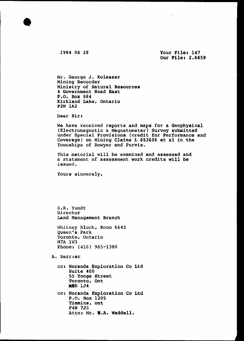
1984 06 28 Your Filet 147 Our Files 2.6859
Mr. George J. KoleszarMining RecorderMinistry of Natural Resources4 Government Road BastP.O. Box 984Kirkland Lake, OntarioP2N 1A2
Dear Sir:
We have received reports and maps for a Geophysical (Electromagnetic 6 Magnetometer) Survey submitted under Special Provisions (credit for Performance and Coverage) on Mining Claims L 653606 et al in the Townships of Bowyer and Purvis.
This material will be examined and assessed and a statement of assessment work credits will be issued.
Yours sincerely,
S.E. YundtDirectorLand Management Branch
Whitney Block, Room 6643Queen's ParkToronto r OntarioM7A 1W3Phone: (416) 965-1380
A. Barr:se
cc: Noranda Exploration Co Ltd Suite 400 55 Yonge Street Toronto, Ont MflE 1J4
cc: Noranda Exploration Co Ltd P.O. Box 1205 Timmins, ont P4N 7J5 Attnt Mr. B.A. Waddell.
Noranda Exploration Company, Limited (no personal liability)
P.O. Box 1205, Timmins, Ont. P4N 7J5
noranda
June 6th, 1984
S.E. Yundt,Director, Land Management Br.,Ministry of Natural Resources,Whitney Block, Room 6643,Queen's Park,Toronto, Ontario.M7A 1W3
Attn: Fred Mathews
Dear Sirs
Enclosed please find reports and maps for Geophysical Surveys
(H.E.M. and Magnetometer) submitted under Special Provisions on
Mining Claims L-653606-611 inclusive in the Township of Bowyer.
Hoping this material meets with your approval.
Yours truly,
NORANDA EXPLORATION CO. LTD.
R.C. Denommee Landsman
c.c. fileRCD/tfEnclosure
J^.Cft
fo
&L
t ^T
L 6
SO
f
65
8
65
36
00
\6
50
66
3 \6
50
S6
2
LO
CA
TIO
N
PLA
N
Bow
yer
2-8
2
/
All
read
ings
in
ra
nge
of
59
00
0
gam
mas
42A16NE0005 2.B859 PURVIS
S0
0
Inst
rum
ent :
G
eom
etric
s G
-81
6
TWR
P
UR
VIS
MA
GN
ETO
ME
TER
S
UR
VE
YFO
R
NO
RAN
DA
EXPL
OR
ATIO
N C
O. L
TDl
PRO
JECT
' A
biti
bi
Wes
t A
rea
(Bow
yer
2-8
2)
SUR
VEYE
D B
Y:
R. C
H.
DRAW
N B
Y'
s.M
.E.
DA
TE
- M
AR
CH
19
84
SC
ALE
* l
-400
ENRG
SE
RV
ICE
S
EX
PLO
RA
TIO
N
SE
RV
ICE
S
REG'D
w..
O:,
o:
uo
"-
h- K UJ v ^ o CD
1-*'o
OG^ * x.
w " tt \
a.**
, On 0/
Vv
•V
D
*o,
r *
'ff.'*
'.?,'^
*,'/v
*o,
'o
''Q
*,
O,
'*.
65
36
06
\65
OG
63~
\65Q
662
i
\
LO
CA
TIO
N
PLA
N
Bowy
er
2-82
Seal
*l"
* 2
640'
,,/
42A!BNE0a05 2.6859 PURVIS
210
Coil
Sepa
ratio
n-.^?
.?..'.
Fr
eque
ncy
...44
4. W
r,
O.P
-.-T
...
l cm
B
l.R * O5
O. R
-IO
Inst
rum
ent 1
M
AX
MIN
H
TW
P
PU
RV
IS
ELE
CTR
OM
AG
NE
TIC
S
UR
VE
Y
NO
RAN
DA
EXPL
OR
ATIO
N C
O. L
TD.
PRO
JEC
T'
Abitib
i W
est
Are
a (B
ow
yer
2-8
2)
SU
RV
EY
ED
BY
' R.
CH.
D
ATE
* MAR
CH
19
84
DR
AW
N
BY:
S.M
.E
SC
ALE
^ l"
'4O
01
ENR
GS
ER
VIC
ES
E
XP
LOR
ATI
ON
S
ER
VIC
ES
RE
G'D
1 450
*5J
199999,
99Q
991
its
ott
irit
ap
ett
tts
ott
i
LO
CA
TIO
N
PL
AN
Bow
yer
2-8
2S
ec/*
l"
* 2
64
0'
42AI6NE8005 2.6859 PURVIS
Coil
Sepa
ratio
n :
Freq
uenc
y i A
77.T
.. . JH
z
l cm
s.
ELE
CTR
OM
AG
NE
TIC
S
UR
VE
YFO
R
NORA
NDA
EXPL
ORA
TIO
N CO
. LTD
i PR
OJE
CT*
Ab
itib
i W
99t
An
a {B
ew
ytr
2-
mttr
unM
nt1
MA
XM
IN H
SURV
EYED
EXPL
ORA
TIO
N