1
India man menistan N Oman Punjab Balochistan Sindh Disputed Territory FATA Gilgit - Baltistan Khyber Pakhtunkhwa AJK Islamabad Map Doc Name: Creation Date: Projection/Datum: Web Resources: iMMAP_Pakistan_Hyderabad_Education Facilities Map_A4L_140809 09 08 14 WGS 1984 http://www.immap.org Map data source(s): Alhasan Pvt Limted (AdminBoundaries,Education Facilities ,WFP (Road Netwotk), National Geo-Spatial Agency. Disclaimers: The designations employed and the presentation of material on this map do not imply the expression of any opinion whatsoever on the part of the iMMAP, Alhasan Systems, or USAID concerning the legal status of any country, territory, city or area or of its authorities, or concerning the delimitation of its frontiers or boundaries. BADIN HYDERABAD JAMSHORO MATIARI T. AYAR T. M KHAN T. M KHAN THATTA Hyderabad City Hyderabad Latifabad Qasimabad Sindh-Hyderabad Population Density Map Date (August 2014) 0 7.5 3.75 Kilometers Arabian Sea Road Network River Indus Tehsil Boundary District Boundary Provincial Boundary International Boundary Legend ! Settlements Population Density Range High Low S.No Tehsil Population Areas (Sq-Km) Pop.Density (Total No. of Persons Sq.Km) 1 Hyderabad 367739 743 495 2 Hyderabad City 642311 21 30976 3 Latifabad 763,539 247 3085 4 Qasimabad 145,464 9 15810 5 Total 1919053 1020 12591.5 2010 Estimated Population

Sindh-Hyderabad Population Density Map · HYDERABAD JAMSHORO MATIARI T.AYAR T. M KHAN T. M KHAN TH A Hyderabad City Hyderabad Latifabad Qasimabad Sindh-Hyderabad Population Density

  • Upload
    others

  • View
    15

  • Download
    0

Embed Size (px)

Citation preview

IndiaOman

Turkmenistan

Nepal

Oman

Punjab

Balochistan

Sindh

Disputed TerritoryFATA

Gilgit - Baltistan

Khyber PakhtunkhwaAJKIslamabad

Map Doc Name:

Creation Date:Projection/Datum:Web Resources:

iMMAP_Pakistan_Hyderabad_Education Facilities Map_A4L_140809

09 08 14WGS 1984

http://www.immap.org

Map data source(s):Alhasan Pvt Limted (AdminBoundaries,Education Facilities,WFP (Road Netwotk), National Geo-Spatial Agency.Disclaimers:The designations employed and the presentation ofmaterial on this map do not imply the expression of anyopinion whatsoever on the part of the iMMAP, AlhasanSystems, or USAID concerning the legal status of anycountry, territory, city or area or of its authorities, orconcerning the delimitation of its frontiers or boundaries.

BADIN

HYDERABAD

JAMSHORO

MATIARI

T. AYAR

T. MKHAN

T. MKHANTHATTA

HyderabadCity

Hyderabad

Latifabad

Qasimabad

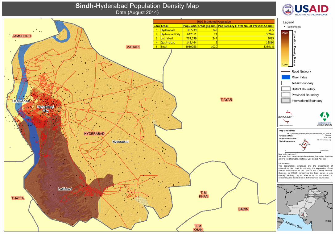
Sindh-Hyderabad Population Density MapDate (August 2014)

0 7.53.75 Kilometers

Arabian Sea

|

Road NetworkRiver IndusTehsil BoundaryDistrict BoundaryProvincial BoundaryInternational Boundary

Legend! Settlements

Population Density RangeHigh

Low

S.No Tehsil PopulationAreas (Sq-Km) Pop.Density (Total No. of Persons Sq.Km) 1 Hyderabad 367739 743 4952 Hyderabad City 642311 21 309763 Latifabad 763,539 247 30854 Qasimabad 145,464 9 158105 Total 1919053 1020 12591.5

2010 Estimated Population