Embed Size (px)
Citation preview
#
#
#
#
#
=
=
Dul
Boma
Belfodiyo
Suqut
Arbodi
Al Khawr
Menge
Megele
JimaGoha
Bugari
Biye Abi
Ora
Muguf
Kidingil
Faragamindoas Sahal
Babarros
`Amarah
Agoramundi
Agani
Uoldong
Kurmuk
Femets'ere
Shimi
Ludu
KurmukZaribah
Kurmuk
Gharbas
Hora
BelefOha
Baro
Asosa
Agolia Afodo
Abenyende
B o l b o l eW e n z
G e n g e nW e n z
1405
1769
1947
1734
1666
Ashura
Sherkole
750
1000
750
750
750
750
1500 1250
750
750
1000
1000
750
1500
1500
1500
1000
1500
1250
1000
1500
1250
750
1000
1750
1500
1000
750
1000
750750
750
750
1000
1250
1000
1250
1250
1250
1000
1250
1000
34°50'0"E
34°50'0"E
34°40'0"E
34°40'0"E
34°30'0"E
34°30'0"E
34°20'0"E
34°20'0"E
10°3
0'0"N
10°3
0'0"N
10°2
0'0"N
10°2
0'0"N
10°1
0'0"N
10°1
0'0"N
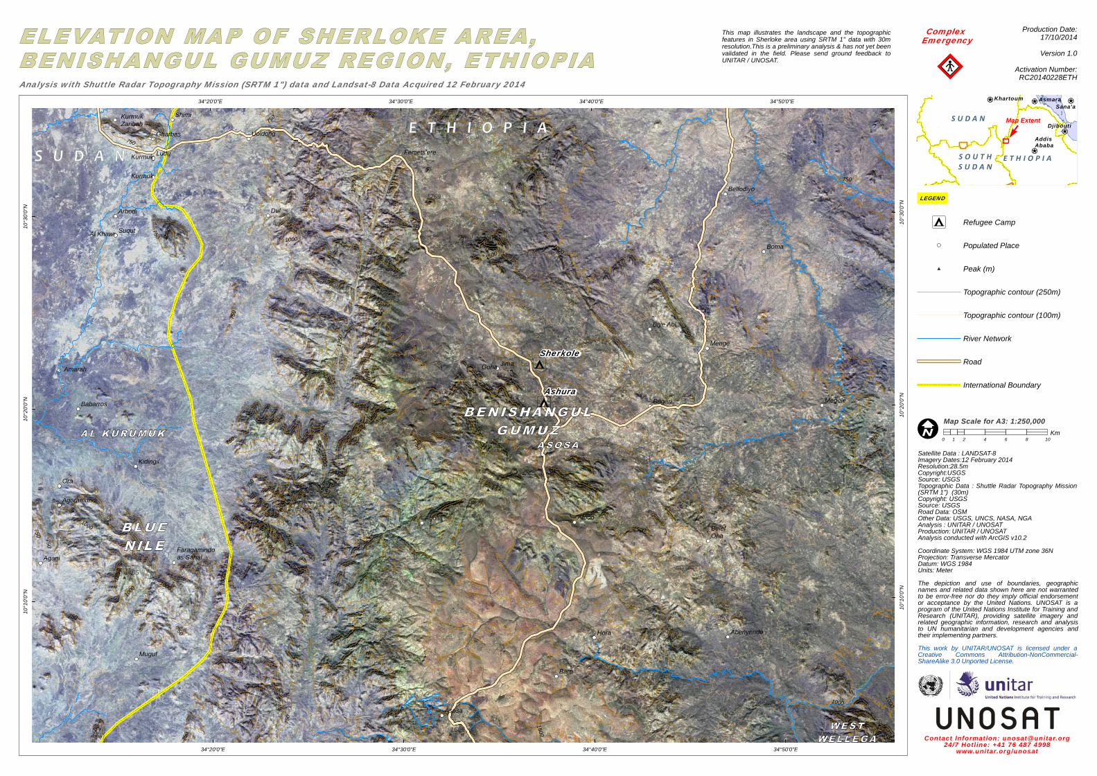
!ISatellite Data : LANDSAT-8Imagery Dates:12 February 2014Resolution:28.5mCopyright:USGSSource: USGSTopographic Data : Shuttle Radar Topography Mission(SRTM 1") (30m)Copyright: USGSSource: USGSRoad Data: OSMOther Data: USGS, UNCS, NASA, NGAAnalysis : UNITAR / UNOSATProduction: UNITAR / UNOSATAnalysis conducted with ArcGIS v10.2Coordinate System: WGS 1984 UTM zone 36NProjection: Transverse MercatorDatum: WGS 1984Units: MeterThe depiction and use of boundaries, geographicnames and related data shown here are not warrantedto be error-free nor do they imply official endorsementor acceptance by the United Nations. UNOSAT is aprogram of the United Nations Institute for Training andResearch (UNITAR), providing satellite imagery andrelated geographic information, research and analysisto UN humanitarian and development agencies andtheir implementing partners.This work by UNITAR/UNOSAT is licensed under aCreative Commons Attribution-NonCommercial-ShareAlike 3.0 Unported License.
Contact Information: [email protected]/7 Hotl ine: +41 76 487 4998
www.unitar.org/unosat
This map illustrates the landscape and the topographicfeatures in Sherloke area using SRTM 1" data with 30mresolution.This is a preliminary analysis & has not yet beenvalidated in the field. Please send ground feedback toUNITAR / UNOSAT.
Complex Emergency
¥¦¬
¥¦¬
¥¦¬¥¦¬ ¥¦¬
AddisAbaba
Djibouti
AsmaraKhartoumSana'a
S U D A N
S O U T HS U D A N
E T H I O P I A
Production Date:17/10/2014Version 1.0
Activation Number:RC20140228ETHAnalysis with Shuttle Radar Topography Mission (SRTM 1") data and Landsat-8 Data Acquired 12 February 2014
0 2 4 6 8 101Km
LEGEND
Map ExtentF
Map Scale for A3: 1:250,000
= Refugee Camp
Populated Place
# Peak (m)
Topographic contour (250m)
Topographic contour (100m)
River Network
Road
International Boundary
!!"