Lake Simcoe
Comprehensive Monitoring Strategy
Cette publication hautement spécialisée Lake Simcoe Comprehensive Monitoring Strategy, n’est disponible qu’en anglais conformément au Règlement 671/92, selon lequel il n’est pas obligatoire de la traduire en vertu de la Loi sur les services en français. Pour obtenir des renseignements en français, veuillez communiquer avec le ministère de l’Environnement et de l’Action en matière de changement climatique au 416-327-1851 ou par courriel à [email protected] .
The comprehensive monitoring strategy (CMS) was prepared in 2014 by Joelle Young from the Biomonitoring Section of the MOECC and Jake La Rose from the Biodiversity and Monitoring Section of the MNRF, with substantial input provided by the CMS working group that consisted of monitoring experts from MOECC, MNRF, LSRCA and EC.
Table of Contents
COMPREHENSIVE MONITORING STRATEGY RECOMMENDATIONS ----------------------------------------- 1
INTRODUCTION ------------------------------------------------ 2
STATE OF MONITORING FOR LSPP ------------------------ 5 Monitoring Recommendations ------------------------------------ 8
STATE OF DATA MANAGEMENT FOR THE LSPP ----- 11 Data Management Recommendations ----------------------- 12
General Recommendations -------------------------------- 12 Data Storage Recommendations ------------------------- 13 Data Documentation Recommendations -------------- 13 Data Sharing Recommendations ------------------------- 14
STATE OF REPORTING FOR LSPP ------------------------ 15 Reporting Recommendations ------------------------------------ 17
BEYOND THE CMS ------------------------------------------- 18
NEXT STEPS --------------------------------------------------- 19
GLOSSARY OF TERMS --------------------------------------- 20
SUPPORTING DOCUMENT I: MONITORING ------------ 22 Appendix A ------------------------------------------------------------ 42 Appendix B ------------------------------------------------------------ 43 Appendix C ------------------------------------------------------------ 44 Appendix D ------------------------------------------------------------ 46 Appendix E ------------------------------------------------------------ 50 Appendix F ------------------------------------------------------------ 51 Appendix G ------------------------------------------------------------ 52
SUPPORTING DOCUMENT II: DATA MANAGEMENT 53 Appendix A ------------------------------------------------------------ 54
SUPPORTING DOCUMENT III: REPORTING ------------ 55 Appendix A ------------------------------------------------------------ 56
Lake Simcoe Comprehensive Monitoring Strategy 1
Page
Comprehensive Monitoring Strategy Recommendations
Monitoring, Data Management and Reporting Monitoring Recommendations
1 Existing monitoring should continue, as it has high importance to the LSPP and/or requires low resources
8
2 LSPP partner agencies should enhance and continue to develop collaboration in monitoring 8 3 A terrestrial natural heritage monitoring program should be designed and implemented in the Lake
Simcoe watershed 8
4 The monitoring of terrestrial animal indicator species should be coordinated and promoted through citizen-science programs
9
9 5 LSPP partner agencies need to consider how to mitigate the risk of cancellation or alteration of monitoring that is led by external agencies but which LSPP implementation relies on
6 Consider monitoring high priority gaps in tributary, near-shore and offshore lake parameters 9 7 A small group of important aquatic parameters should be monitored at less frequent intervals
(every 5–10 years) than most other parameters 10
8 To address LSPP climate change information needs: 10 • Monitoring of many existing long-term parameters should be continued • Further analysis of existing monitoring data should be conducted • Where possible, climate change monitoring should be standardized across other watersheds
Data Management Recommendations
1 Data should be housed with the Primary Agency who performs monitoring 12 2 There is a requirement for clear lines of accountability by primary Agencies (data owner/steward)
for the management of data collected in support of monitoring Lake Simcoe 12
3 Ongoing resource requirements for data management should be recognized by primary Agencies 13 4 It is recommended that all data are transferred to and stored in a database management system
(DBMS) 13
5 Newly collected monitoring data should be regularly appended to appropriate existing databases within a defined time period after data preparation
13
13 6 Backing-up and archiving should be continued by following the Primary Agency’s best practices, which should include off-site backing up and the use of universally recognizable software
7 Data management plans should be documented and kept current 13 8 All Lake Simcoe data should have a metadata record 14 9 Lake Simcoe data should continue to be openly shared, using the Freedom of Information and
Protection of Privacy Act (FIPPA) as a guideline for access to data 14
10 Distributed data that is not QA-QCed should be properly identified 14
Reporting Recommendations
1 Continue to produce frequent scientific and technical reporting in order to meet LSPP information needs
17
2 Make existing reports more easily searchable and available to a variety of audiences (agencies, stakeholders, public)
17
3 Consider producing a collaborative multi-agency report that presents highlights of ecological and environmental state and trends of Lake Simcoe for public consumption
17
Lake Simcoe Comprehensive Monitoring Strategy 2
Introduction
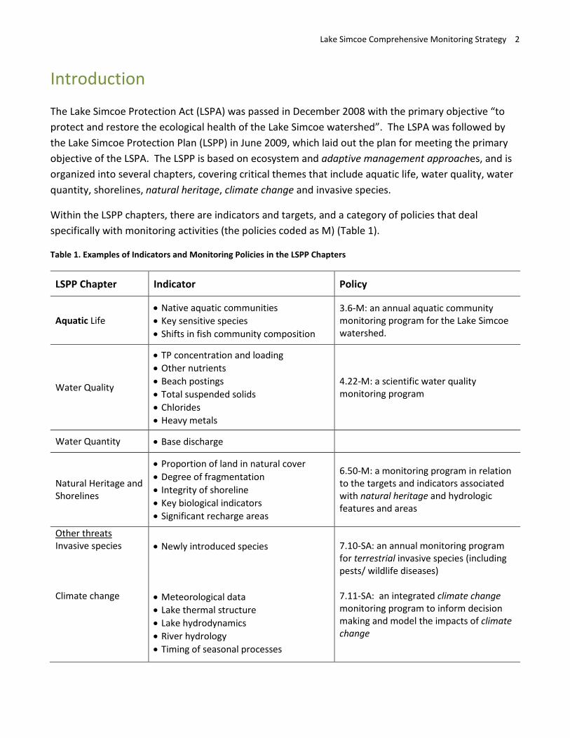
The Lake Simcoe Protection Act (LSPA) was passed in December 2008 with the primary objective “to protect and restore the ecological health of the Lake Simcoe watershed”. The LSPA was followed by the Lake Simcoe Protection Plan (LSPP) in June 2009, which laid out the plan for meeting the primary objective of the LSPA. The LSPP is based on ecosystem and adaptive management approaches, and is organized into several chapters, covering critical themes that include aquatic life, water quality, water quantity, shorelines, natural heritage, climate change and invasive species.
Within the LSPP chapters, there are indicators and targets, and a category of policies that deal specifically with monitoring activities (the policies coded as M) (Table 1).
Table 1. Examples of Indicators and Monitoring Policies in the LSPP Chapters
LSPP Chapter Indicator Policy
Aquatic Life • Native aquatic communities • Key sensitive species • Shifts in fish community composition
3.6-M: an annual aquatic community monitoring program for the Lake Simcoe watershed.
Water Quality
• TP concentration and loading • Other nutrients • Beach postings • Total suspended solids • Chlorides • Heavy metals
4.22-M: a scientific water quality monitoring program
Water Quantity • Base discharge
Natural Heritage and Shorelines
• Proportion of land in natural cover • Degree of fragmentation • Integrity of shoreline • Key biological indicators • Significant recharge areas
6.50-M: a monitoring program in relation to the targets and indicators associated with natural heritage and hydrologic features and areas
Other threats Invasive species • Newly introduced species 7.10-SA: an annual monitoring program
for terrestrial invasive species (including pests/ wildlife diseases)
Climate change • Meteorological data • Lake thermal structure • Lake hydrodynamics • River hydrology • Timing of seasonal processes
7.11-SA: an integrated climate change monitoring program to inform decision making and model the impacts of climate change
Lake Simcoe Comprehensive Monitoring Strategy 3
These were designed by experts from the partner agencies involved in monitoring and the Lake Simcoe Science Committee to track the progress of actions for protecting and restoring the ecological health of Lake Simcoe and its watershed. Indicators, targets and monitoring are a critical component of policy implementation and the adaptive management approach; monitoring information feeds directly into the policy cycle by helping to identify the need for new or adjusted management actions, measuring policy outcomes and helping to ensure that policy is evidence based. The adaptive management approach of the LSPP requires feedback on performance in order to measure its effectiveness. For ecological and environmental focussed policy and management, this feedback comes from the repeated monitoring of indicators over many years (i.e., long term), the proper management of the data collected, and prompt reporting to inform watershed partners on the findings of the monitoring results. As such, the LSPP called for a comprehensive monitoring strategy (CMS):
“collaborate to design and implement a comprehensive monitoring strategy for the Lake Simcoe watershed. The Plan also provides for the development of new, or the enhancement of existing monitoring programs needed to fill current monitoring gaps. A comprehensive coordination strategy will help to ensure that required data are available in a suitable format and that monitoring efforts are not being duplicated.”
To meet this objective, a team of experts worked together to develop recommendations on monitoring, data management and reporting to inform management of a path forward for the comprehensive monitoring of Lake Simcoe.
Who was involvedThe development of the CMS was a collaborative effort that took place from 2011 to 2013. A multi-agency working group was formed with the Environmental Monitoring and Reporting Branch of the Ministry of the Environment and Climate change (MOECC) having overall responsibility for the project. A Steering Committee represented by MOECC and the Ministry of Natural Resources and Forestry (MNRF) (Supporting Document I, Appendix A) developed the terms of reference for the CMS and were responsible for providing guidance to the working group when needed. The working group was co-chaired by MOECC and MNRF, and was composed of monitoring experts from all agencies involved in LSPP implementation: MOECC, MNRF, the Ministry of Agriculture, Food and Rural Affairs (MAFRA), Lake Simcoe Region Conservation Authority (LSRCA) and Environment Canada (EC) (Supporting Document I, Appendix A). For data management and reporting sections, the working group was divided in half based on member expertise, with additional experts added to the data management sub-working group. The Lake Simcoe Operational Management Committee and the Lake Simcoe Science Committee (LSSC) provided review and feedback on the CMS throughout its development, and four LSSC members were also on the CMS working group.
Lake Simcoe Comprehensive Monitoring Strategy 4
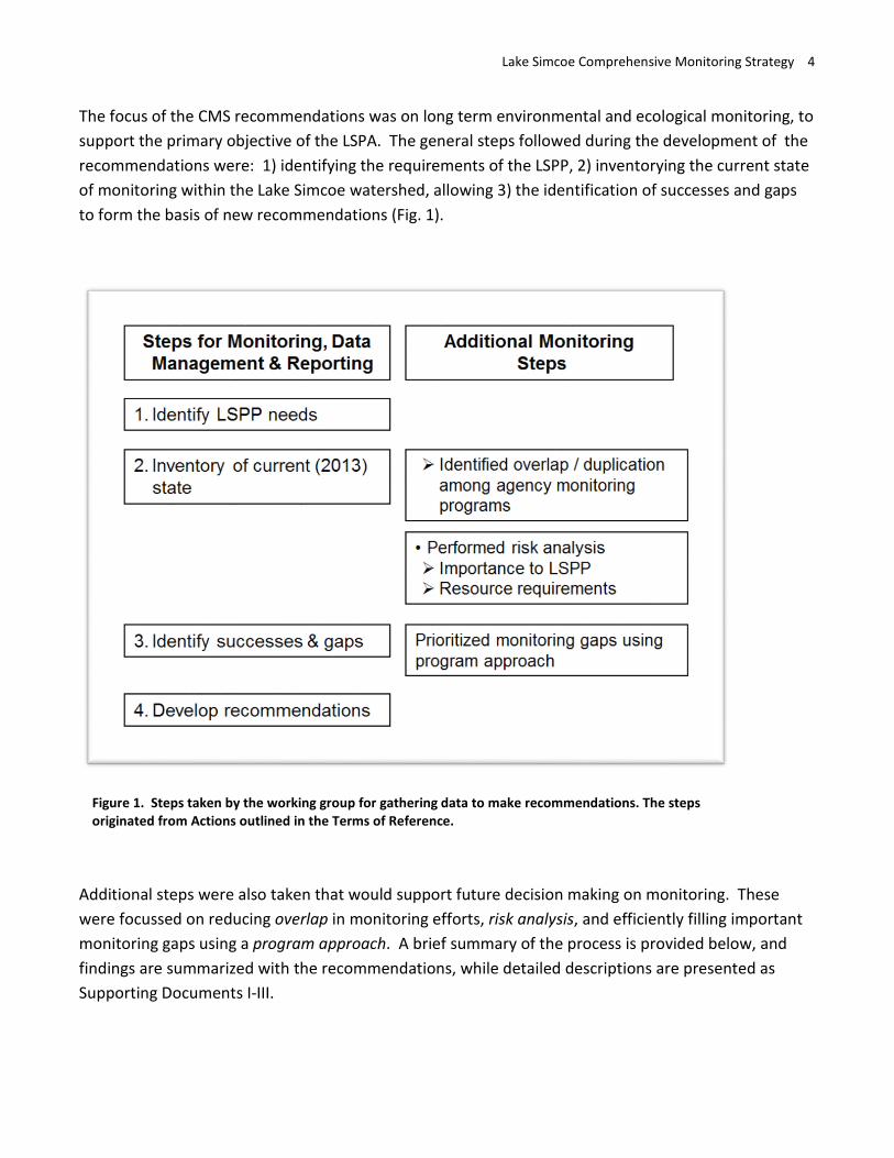
The focus of the CMS recommendations was on long term environmental and ecological monitoring, to support the primary objective of the LSPA. The general steps followed during the development of the recommendations were: 1) identifying the requirements of the LSPP, 2) inventorying the current state of monitoring within the Lake Simcoe watershed, allowing 3) the identification of successes and gaps to form the basis of new recommendations (Fig. 1).
Steps for Monitoring, Data Management & Reporting
Additional Monitoring Steps
1. Identify LSPP needs
2. Inventory of current (2013) state
Identified overlap I duplication among agency monitoring programs
Performed risk analysis Importance to LSPP Resource requirements
3. Identify successes & gaps Prioritized monitoring gaps using program approach
4. Develop recommendations
Figure 1. Steps taken by the working group for gathering data to make recommendations. The steps originated from Actions outlined in the Terms of Reference.
Additional steps were also taken that would support future decision making on monitoring. These were focussed on reducing overlap in monitoring efforts, risk analysis, and efficiently filling important monitoring gaps using a program approach. A brief summary of the process is provided below, and findings are summarized with the recommendations, while detailed descriptions are presented as Supporting Documents I-III.
Lake Simcoe Comprehensive Monitoring Strategy 5
State of Monitoring for LSPP
Lake Simcoe has a long history of intensive environmental and ecological monitoring. In the 1970s and 1980s, these programs were fundamental in tracking declines in the lake’s health, as well as identifying stressors. In recent years, the long term monitoring data has shown improvements in the lake as a result of protection and restoration efforts, and has detected emerging stressors, such as invasive species and climate change.
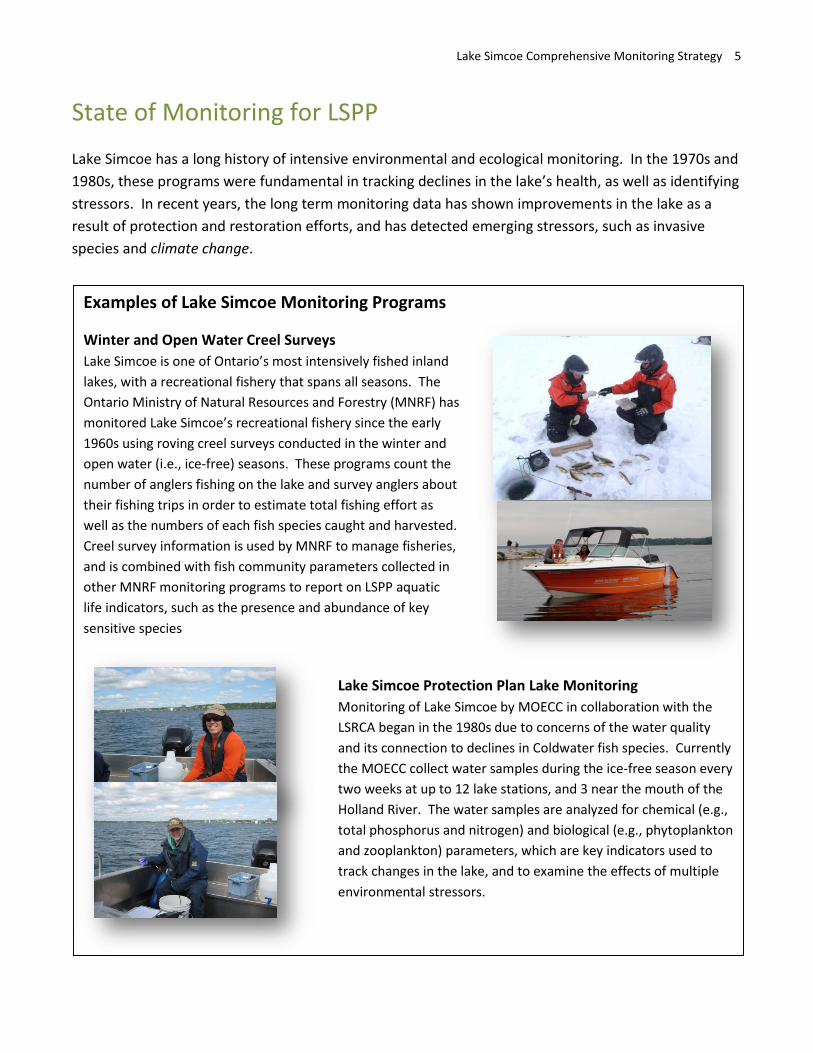
Examples of Lake Simcoe Monitoring Programs
Winter and Open Water Creel Surveys Lake Simcoe is one of Ontario’s most intensively fished inland lakes, with a recreational fishery that spans all seasons. The Ontario Ministry of Natural Resources and Forestry (MNRF) has monitored Lake Simcoe’s recreational fishery since the early 1960s using roving creel surveys conducted in the winter and open water (i.e., ice-free) seasons. These programs count the number of anglers fishing on the lake and survey anglers about their fishing trips in order to estimate total fishing effort as well as the numbers of each fish species caught and harvested. Creel survey information is used by MNRF to manage fisheries, and is combined with fish community parameters collected in other MNRF monitoring programs to report on LSPP aquatic life indicators, such as the presence and abundance of key sensitive species
Lake Simcoe Protection Plan Lake Monitoring Monitoring of Lake Simcoe by MOECC in collaboration with the LSRCA began in the 1980s due to concerns of the water quality and its connection to declines in Coldwater fish species. Currently the MOECC collect water samples during the ice-free season every two weeks at up to 12 lake stations, and 3 near the mouth of the Holland River. The water samples are analyzed for chemical (e.g., total phosphorus and nitrogen) and biological (e.g., phytoplankton and zooplankton) parameters, which are key indicators used to track changes in the lake, and to examine the effects of multiple environmental stressors.
Lake Simcoe Comprehensive Monitoring Strategy 6
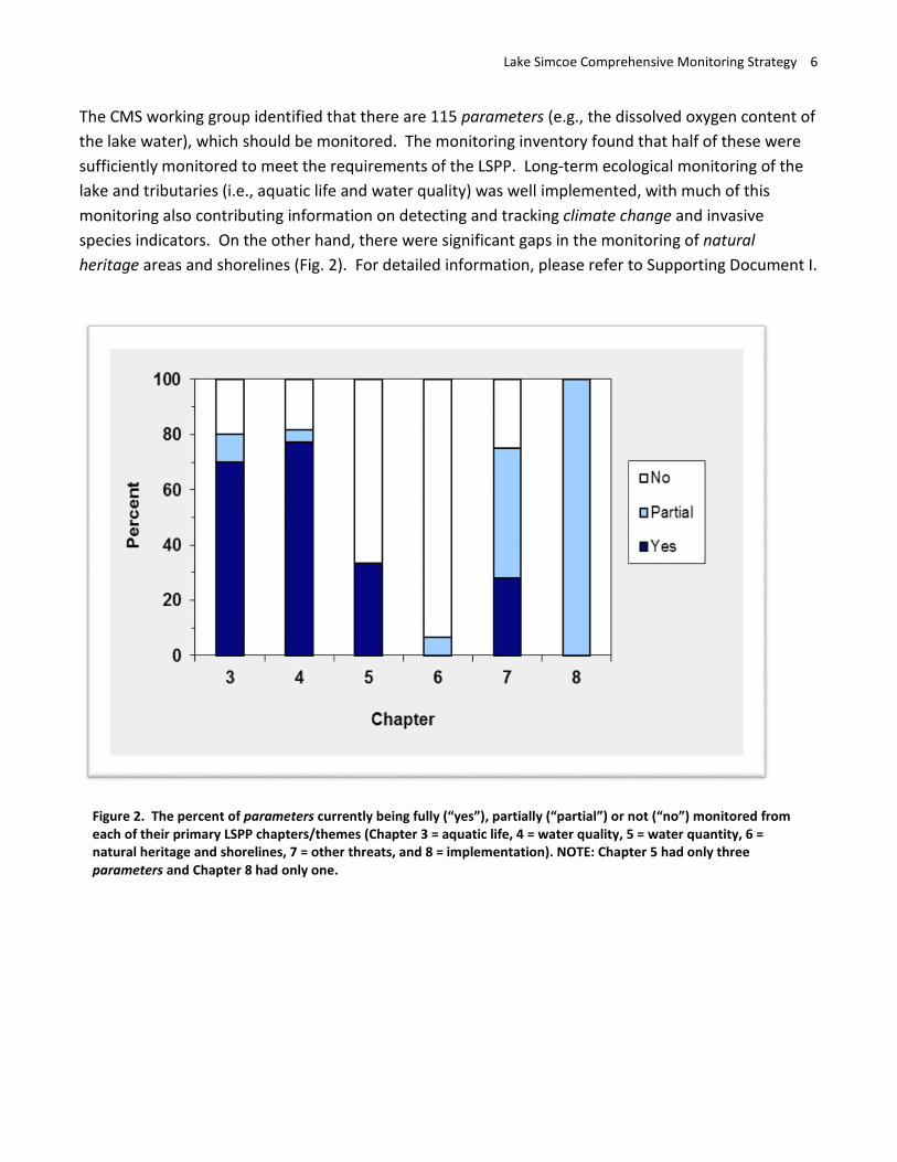
The CMS working group identified that there are 115 parameters (e.g., the dissolved oxygen content of the lake water), which should be monitored. The monitoring inventory found that half of these were sufficiently monitored to meet the requirements of the LSPP. Long-term ecological monitoring of the lake and tributaries (i.e., aquatic life and water quality) was well implemented, with much of this monitoring also contributing information on detecting and tracking climate change and invasive species indicators. On the other hand, there were significant gaps in the monitoring of natural heritage areas and shorelines (Fig. 2). For detailed information, please refer to Supporting Document I.
Figure 2. The percent of parameters currently being fully (“yes”), partially (“partial”) or not (“no”) monitored from each of their primary LSPP chapters/themes (Chapter 3 = aquatic life, 4 = water quality, 5 = water quantity, 6 = natural heritage and shorelines, 7 = other threats, and 8 = implementation). NOTE: Chapter 5 had only three parameters and Chapter 8 had only one.
Lake Simcoe Comprehensive Monitoring Strategy 7
Key Monitoring Successes: • Half of the monitoring required by the LSPP is being performed, especially for
aquatic life and water quality • This existing monitoring was ranked as extremely important to the LSPP, relatively
cost efficient, or both
Key Monitoring Gaps: • Natural heritage and shorelines are significantly under-represented in current
monitoring
Results of the Program Approach
Recommendations for filling important monitoring gaps were developed around high priority monitoring needs based on a cost-effective program approach. This approach assumed that a monitoring program could collect multiple samples on the same sampling trip thus increasing efficiency. The working group identified existing monitoring programs that could be enhanced to monitor parameters identified as gaps and suggested new programs designed to capture a suite of the important monitoring gaps that could not be covered within existing programs.
Almost two-thirds of the gaps, many of which had high importance to the LSPP, were grouped into existing or new programs (for details, see Supporting Document I, Appendix F).
These programs were prioritized by the working group as: 1. Large Scale Terrestrial Mapping (New Program) 2. Site Level Terrestrial Inventory (New Program) 3. Nearshore Monitoring (Additions to Existing Program) 4. Animal Indicator Species (Coordinated Program) 5. Base-discharge in Tributaries (New Program) 6. LSPP Lake Monitoring (Additions to Existing Program) 7. LSPP Tributary Monitoring (Additions to Existing Program)
The working group also made suggestions for reclassifying five of the gaps as research projects rather than routine monitoring, given the infrequency of data collection required to fill them. For more details, see Supporting Document I.
Lake Simcoe Comprehensive Monitoring Strategy 8
Monitoring Recommendations 1. Existing monitoring should continue, as it has high importance to the LSPP and/or requires low
resources
Lake Simcoe and its watershed have had several long term, intensive monitoring programs in place for a number of years, in some cases decades. While the extent of these programs have fluctuated in some years, the information gathered is critical to meeting the objectives of the Lake Simcoe Protection Plan. This monitoring fulfills many policy requirements within the LSPP, including meeting the intent of M-policies and tracking the defined targets and indicators of lake and watershed health. Key examples of these key long term initiatives are the monitoring of dissolved oxygen (DO) concentration and recreational fisheries. DO forms the basis of a target within the LSPP aquatic life chapter and is an indicator of water quality, while monitoring of the recreational fisheries informs us on the coldwater fish communities response to improved DO. To continue meeting the requirements of the LSPP, agencies must ensure that existing high priority monitoring continues.
2. LSPP partner agencies should enhance and continue to develop collaboration in monitoring
Very little duplication and excellent collaboration was found among agencies monitoring Lake Simcoe and its watershed. To maintain an efficient monitoring program, agencies should continue to enhance and develop collaborations. Since regular communication is important to facilitate these collaborations, agencies should participate in annual or bi-annual meetings to share information, and discuss LSPP monitoring needs and how to meet them.
3. A terrestrial natural heritage monitoring program should be designed and implemented in the Lake Simcoe watershed
A terrestrial natural heritage monitoring program that includes both site level inventory and large scale mapping components is a high priority need for the LSPP. Large scale mapping would use remote sensing to measure “Extent and distribution” and “Fragmentation and Spatial Context” of various habitat types that directly relate to plan targets, whereas the site level inventory directly measures the in-situ “Habitat Structure” and “Species composition” of habitat types allowing for reporting on ecological health. Together these components would serve LSPP policy 6.50-M, as well as important terrestrial aspects of the invasive species monitoring policy (7.10-M) and climate change monitoring needs (7.11c-SA) that are currently not implemented. In addition, repeated large-scale and site-level measurements will allow agencies to measure changes over time in indicators of natural heritage, invasive species and climate change, and report on whether targets and objectives are being met. Targets for natural heritage include a minimum of 40% high quality natural vegetative cover and an increase in large patches of cover, neither of which can be reported on without a monitoring program. LSPP partner agencies are currently involved in
Lake Simcoe Comprehensive Monitoring Strategy 9
designing and testing aspects of this program, which, if implemented could serve as the starting point for these measurements.
4. The monitoring of terrestrial animal indicator species should be coordinated and promoted through citizen-science programs
Terrestrial animal indicator species need to be monitored as natural heritage indicators, and to support terrestrial invasive species and climate change monitoring programs. Some information on terrestrial animal species is currently collected through citizen science groups and other programs external to the LSPP. Although this information cannot fully meet LSPP monitoring needs, the promotion and coordination of technical details of citizen science programs, as well as partnering with external agencies and organizations to share data, could increase their viability in the watershed. For example, a program such as Bird Studies Canada’s Marsh Monitoring Program, which is a standardized, nationally implemented volunteer program, could prioritize species and areas for monitoring within the watershed to help monitor the impacts of climate change (see http://www.bsc-eoc.org/mmptell.html). Additional effort could be put towards promoting Lake Simcoe specific participation in the program.
5. LSPP partner agencies need to consider how to mitigate the risk of cancellation or alteration of monitoring that is led by external agencies but which LSPP implementation relies on.
Some parameters that are very important to LSPP implementation are monitored by external agencies or are supported by external funding. For example, Environment Canada meteorological site data is used in phosphorus load calculations and to track climate change indicators. LSPP partner agencies should identify risks to their programs and plan potential ways to adapt or continue this essential work in the event that it was cancelled or altered significantly by an external agency or funding partner.
6. Consider monitoring high priority gaps in tributary, nearshore and offshore lake parameters
Some high priority gaps were identified within existing aquatic monitoring programs, which are needed to report on indicators of water quality, measure progress on LSPP objectives and meet the requirements of the water quality monitoring policy 4.22-M. These gaps included total suspended solids in lake water, zebra and quagga mussel abundance, and organic contaminants. The need and frequency for each gap should be evaluated in order to further prioritize those to monitor. Many of these could be added to existing aquatic monitoring programs with marginal additional resource requirements (for details, see Supporting Document I, Appendix F).
Lake Simcoe Comprehensive Monitoring Strategy 10
7. A small group of important aquatic parameters should be monitored at less frequent intervals (every 5–10 years) than most other parameters
Some LSPP information needs, such as contaminants in sediments, are expected to fluctuate over longer time scales; therefore, frequent (i.e., annual) monitoring would not be required. Many of these are explicitly called for within water quality policies such as 4.22-M and 4.23-SA. This monitoring should be on a periodic basis (e.g., every 5–10 years) that is implemented as a special need.
8. To address LSPP climate change information needs a. Monitoring of many existing long-term parameters should be continued b. Further analysis of existing monitoring data should be conducted c. Where possible, climate change monitoring should be standardized across other
watersheds
Many ecological parameters that were identified as important for climate change monitoring are currently monitored as part of other long-term monitoring programs, and thus climate change monitoring was identified in the Lake Simcoe Climate Change Adaption Strategy as part of the Comprehensive Monitoring Strategy. As long-term, continuous data is needed to determine the impacts of climate change, ongoing monitoring should continue, and some additional high priority monitoring should be initiated (e.g., lake trout phenology). Priority should be placed on analyzing existing data to help serve LSPP climate change policy needs. Lastly, because the impacts of climate change extend beyond the Lake Simcoe watershed, the monitoring of climate change parameters for Lake Simcoe should be standardized with similar work done across other watersheds and at larger scales.
Lake Simcoe Comprehensive Monitoring Strategy 11
State of Data Management for the LSPP
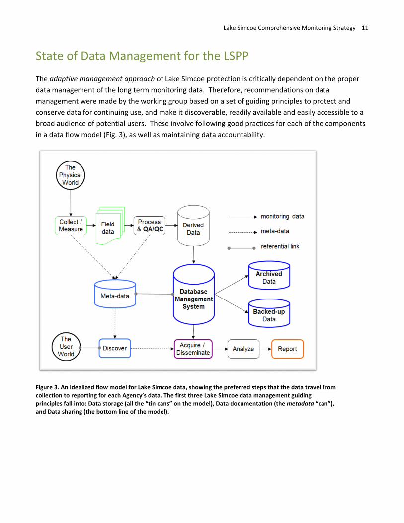
The adaptive management approach of Lake Simcoe protection is critically dependent on the proper data management of the long term monitoring data. Therefore, recommendations on data management were made by the working group based on a set of guiding principles to protect and conserve data for continuing use, and make it discoverable, readily available and easily accessible to a broad audience of potential users. These involve following good practices for each of the components in a data flow model (Fig. 3), as well as maintaining data accountability.
Figure 3. An idealized flow model for Lake Simcoe data, showing the preferred steps that the data travel from collection to reporting for each Agency’s data. The first three Lake Simcoe data management guiding principles fall into: Data storage (all the “tin cans” on the model), Data documentation (the metadata “can”), and Data sharing (the bottom line of the model).
Lake Simcoe Comprehensive Monitoring Strategy 12
Guiding principles of Lake Simcoe data management (similar to principles in MNRF’s Information Management Strategy, 2006)
1. Protect and conserve data for continuing use, 2. Make data discoverable, 3. Make data readily available and easily accessible to a broad audience of
potential users.
Key Data Management Successes: For the most part, Lake Simcoe monitoring data are being:
• adequately stored • regularly up-dated • properly maintained, and • appropriately shared.
Key Data Management Gaps: • Although much of the data are managed following commonly accepted good data
management practices (Fig. 3), some data management practices require improvements, specifically regarding how the data are stored.
• An ongoing resource commitment is required to ensure data are updated, maintained, and remain accessible with currently supported software.
• There is insufficient documentation for approximately half of the datasets, which may limit how useable they are by others or into the future. Additionally, there is a lack of accessible documentation (e.g., metadata) of the datasets, which prevents them from being discoverable.
Data Management Recommendations
General Recommendations 1. Data should be housed with the primary Agency who performs monitoring
The primary Agency has the relevant knowledge of the data and should accept responsibility for ongoing maintenance of the data. It is impractical for all data to be stored in a single central repository.
2. There is a requirement for clear lines of accountability by primary Agencies (data owner/steward) for the management of data collected in support of monitoring Lake Simcoe
The primary Agency that collects and houses the long term monitoring data should formally assign a data custodian within the primary Agency, and should have a set succession plan so that the care
Lake Simcoe Comprehensive Monitoring Strategy 13
of datasets will be maintained when staff retire or leave the position to which the data custodian role was assigned.
3. Ongoing resource requirements for data management should be recognized by primary Agencies.
Good data management practices require resources (e.g., staff and infrastructure), which should be clearly identified and prioritized by primary Agencies.
Data Storage Recommendations 4. It is recommended that all data are transferred to and stored in a database management system
(DBMS).
Data for approximately one-quarter of Lake Simcoe parameters are currently stored on spreadsheets and not in a DBMS. Use of a DBMS will ensure data stability and reduce resource requirements in the long-term, as it will take less time to fulfill data requests, as well as ease data migration to newer software and hardware.
5. Newly collected monitoring data should be regularly appended to appropriate existing databases within a defined time period after data preparation.
Approximately one-quarter of Lake Simcoe data are not regularly updated, and those that are regularly updated require an ongoing commitment of resources to stay up-to-date.
6. Backing-up and archiving should be continued by following the Primary Agency’s best practices, which should include off-site backing-up and the use of universally recognizable software.
Most of Lake Simcoe data are safely and securely backed-up and archived. Ideally, data should be housed on a network server but a local PC is sufficient if data are backed up regularly to an offsite network server. Some of Lake Simcoe stored, backed-up and/or archived data are at risk of becoming unusable. To ensure continued accessibility of data, all data should be stored, backed-up and archived using universally recognizable and current/compatible software, formats or platforms. If software used to manage the data are no longer in standard use, archives should be migrated to a new format to retain accessibility.
Data Documentation Recommendations 7. Data management plans should be documented and kept current.
Over half of the parameters have a data management plan, which ensure data are interpretable and properly analyzed by future or external users.
Lake Simcoe Comprehensive Monitoring Strategy 14
8. All Lake Simcoe data should have a metadata record.
About half of the Lake Simcoe data have a metadata record. All data should have metadata records that: • are in a common platform, such as M2, an open-source freeware hosted by the MNRF.
Resources would be required for the migration of existing metadata to M2. • are easily accessible by the public so that Lake Simcoe data are discoverable. • include, at a minimum, basic information required to assist others in interpreting data in the
future. Without this information, data will have limited long term value. • have a link to data management plans to ensure proper analysis of the data, • should be kept up-to-date. Responsibility of metadata refreshment should be assigned to a
single agency who would remind other agencies to update metadata in M2. • could be directly downloadable from a metadata management system (e.g., M2) or a data
distribution site to accommodate an increase in the number of data requests that may occur due to increased discoverability; additional resources might be required.
Data Sharing Recommendations 9. Lake Simcoe data should continue to be openly shared, using the Freedom of Information and
Protection of Privacy Act (FIPPA) as a guideline for access to data.
Currently, almost all of Lake Simcoe data are openly shared as soon as they have been processed and are ready for dissemination. This sharing should continue following FIPPA guidelines, where there are two circumstances described when Lake Simcoe data could be withheld, specifically, sensitive species records (Section 21.1) and data soon to be published in reports or papers (Section 22):
http://www.e-laws.gov.on.ca/html/statutes/english/elaws_statutes_90f31_e.htm#BK30
10. Distributed data that is not QA-QCed should be properly identified.
Some of Lake Simcoe data are distributed without having been QA-QCed. In this case, a disclaimer should be included with the data that alerts the user that the data are not QA-QCed and requests that any discrepancies be reported to the data custodian within the responsible agency. Possible examples can be found at:
http://www.ontario.ca/government/ontario-open-data-terms-use
Lake Simcoe Comprehensive Monitoring Strategy 15
State of Reporting for LSPP
Within the LSPP and LSPA, there are four well defined, science focussed, environmental and ecological reporting requirements. Each of these reporting requirements cover a wide range of topics that are intended to communicate findings to a wide range of audiences (i.e., from technical and scientific to the general public). LSPP partner agencies are successfully fulfilling these explicit reporting requirements by reporting the results of water quality monitoring, preparing subwatershed plans, holding the biennial Lake Simcoe Science Forum, and releasing a report that presents the results of all monitoring programs on the Lake Simcoe watershed. For more details on Reporting Results, see Supporting Document III.
Ecological and environmental reporting requirements of the LSPP and LSPA: 1. 4.22-M (b): Performance monitoring and reporting that evaluates the
effectiveness of protection measures specified in this Plan that are designated to improve water quality
2. 8.1-SA, (c): Monitoring and reporting in relation to subwatershed targets that may be established
3. 8.12-SA: Every two years the partner agencies will organize an event or events that focus on scientific monitoring and research
4. LSPA Section 12(2) / Pg. 78 of the LSPP: Every 5 years report on all Lake Simcoe monitoring programs
In addition to meeting the explicit monitoring requirements of the LSPP, partner agencies have increased the frequency, scope and volume of ecological and environmental focused scientific reporting. A considerable body of technical scientific reporting has been produced, primarily targeting agency and academic audiences, since the introduction of the LSPP. Government reports, peer-reviewed publications, fact sheets/information summaries and conference symposia contributions have been produced to report on water quality, phosphorus loading, aquatic plants, invasive species, tributary and lake fish communities, the sport fishery monitoring, among other topics (see Table 3 for details). This technical scientific reporting of monitoring information has supported many other functions of the LSPP including adaptive management, public reporting, science syntheses and research activities.
Lake Simcoe Comprehensive Monitoring Strategy 16
Key Reporting Successes: • Partner agencies are meeting LSPA and LSPP reporting requirements • LSPP investments in monitoring have resulted in a substantial increase in the frequency,
scope and volume of technical reporting produced by agencies.
Key Reporting Gaps: • Existing reports could be made more easily available to a variety of audiences. Currently
there is no central listing of monitoring reports and the mode of access to them often differs by agency.
• Public focussed reporting could be enhanced so that the information contained in technical reports is communicated in plain language and is more accessible to the public.
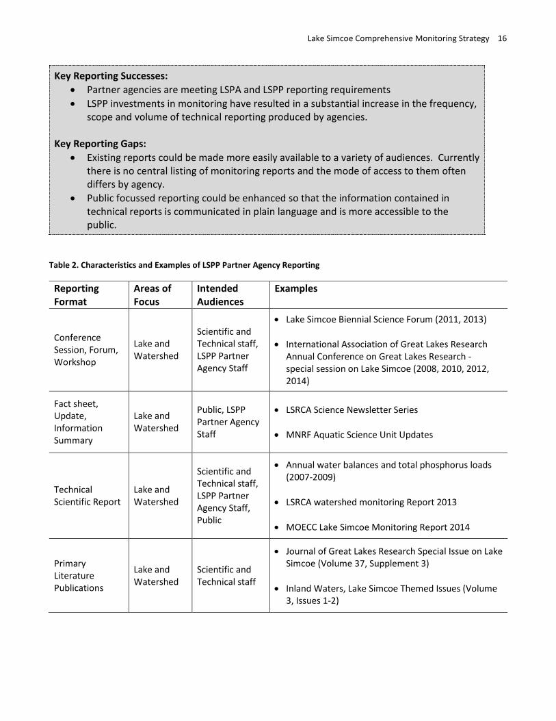
Table 2. Characteristics and Examples of LSPP Partner Agency Reporting
Reporting Format
Areas of Focus
Intended Audiences
Examples
Conference Session, Forum, Workshop
Lake and Watershed
Scientific and Technical staff, LSPP Partner Agency Staff
• Lake Simcoe Biennial Science Forum (2011, 2013)
• International Association of Great Lakes Research Annual Conference on Great Lakes Research - special session on Lake Simcoe (2008, 2010, 2012, 2014)
Fact sheet, Update, Information Summary
Lake and Watershed
Public, LSPP Partner Agency Staff
• LSRCA Science Newsletter Series
• MNRF Aquatic Science Unit Updates
Technical Scientific Report
Lake and Watershed
Scientific and Technical staff, LSPP Partner Agency Staff, Public
• Annual water balances and total phosphorus loads (2007-2009)
• LSRCA watershed monitoring Report 2013
• MOECC Lake Simcoe Monitoring Report 2014
Primary Literature Publications
Lake and Watershed
Scientific and Technical staff
• Journal of Great Lakes Research Special Issue on Lake Simcoe (Volume 37, Supplement 3)
• Inland Waters, Lake Simcoe Themed Issues (Volume 3, Issues 1-2)
Lake Simcoe Comprehensive Monitoring Strategy 17
Reporting Recommendations The following recommendations are presented to sustain and enhance science focused, environmental and ecological reporting for the LSPP.
1. Continue to produce frequent scientific and technical reporting in order to meet LSPP information needs
The monitoring and reporting requirements of specific policies in the LSPP provide clear and essential direction to environmental management agencies. Significant and timely progress has been achieved towards meeting these requirements. It is vital to continue to meet these requirements and to produce the frequent, scientific and technical reporting that has supported the LSPP over the past 5 years.
2. Make existing reports more easily searchable and available to a variety of audiences (agencies, stakeholders, public)
While many reports produced by agencies are made available to all audiences, seeking out these reports requires detailed knowledge of agency roles and organizational structures. There is a need for a single central listing of monitoring reports so that all audiences can search and discover this work for Lake Simcoe and its watershed. Currently the mode of access to reports also often differs by agency/organizational unit (e.g., by request, posted on internet, internal agency repository). Where possible, a central listing or repository of reports produced by all agencies would help ensure reports are accessible and archived for future accessibility.
3. Consider producing a collaborative multi-agency report that presents highlights of ecological and environmental state and trends of Lake Simcoe for public consumption
Public focussed reporting for the LSPP could be enhanced by producing a regular, public facing report that presents key findings from Lake Simcoe`s lake and watershed monitoring programs. This kind of report could be produced as a collaborative multi-agency effort, which translates the information contained in technical reports into plain language for the public and stakeholders. The technical Lake Simcoe Monitoring Report 2014, which this CMS report is a companion to, and the upcoming public Minister’s 5-year report present an opportunity to help to fine tune the topics and content for a regular multi-agency public report. The following options are suggested: • regular frequency • focusing on timely highlights of key monitoring results, even balance of lake and watershed
topics • geographical referencing where possible (e.g., the state of sub-watersheds)
Lake Simcoe Comprehensive Monitoring Strategy 18
• formatting that considers how the public wants to receive information, which may require additional research using innovative ways for distributing information (e.g., web portal, use of social media)
• using hierarchical or nested levels of technical detail, where possible
The following are potential requirements for reporting recommendation 3: • additional resources to support enhanced reporting to the public • a technical/scientific working group (similar to the CMS working group) • communications expertise
Beyond the CMS
While the objective of CMS was to identify long-term ecological monitoring as presented in the LSPP, many related monitoring topics were discussed during the working group meetings. The following summarizes those topics:
1. Monitoring was characterized at the most practical level of detail, the parameter. The sampling effort, i.e., spatial and temporal scale of data collection, for each parameter was determined by the opinion of experts as opposed to reviewing detailed technical/statistical aspects of each parameter. More detailed recommendations for monitoring relating to sampling effort have been made in separate documents, such as sub-watershed plans, and through program reviews conducted by individual agencies.
2. Research needs were not itemized; however, many research initiatives were identified as having important links to monitoring. Monitoring data have proven central to answering key research questions. Research findings can also help to guide long-term monitoring programs, and there are research related policies in most chapters. Additionally, some monitoring originally identified as long term was reclassified as short term information needs (e.g., investigation of sources of pathogens), and some inventory and mapping needs, such as tributary barriers and channelization for policy 3.4-SA, were identified but not reported as long term monitoring requirements during the program prioritization exercise.
3. Through the course of the CMS development many other LSPP needs were identified that were peripherally related to long term environmental and ecological monitoring or related to other kinds of monitoring or evaluation (e.g., monitoring Plan implementation, effectiveness and performance monitoring). Many of these needs have or will be addressed by other concurrent LSPP initiatives: • Implementation and performance monitoring for LSPP stewardship activities was being
addressed by a Lake Simcoe Stewardship working group
Lake Simcoe Comprehensive Monitoring Strategy 19
• Actions taken as part of the phosphorus reduction strategy and related initiatives will help guide the use of BMPs
• The upcoming public Minister’s 5-year report will present the findings of long-term monitoring and review progress towards meeting LSPP targets
• The Minister’s 10-year review of the LSPP could include a review of targets and indicators and consider the need for additional ones
• Lake Simcoe committees, such as Lake Simcoe Fisheries Management Committee and Lake Simcoe Science Committee, will continue to make suggestions on the ecological monitoring of Lake Simcoe.
Next Steps
Lake Simcoe CMS working group will continue to meet biannually or annually, bringing in the LSSC as necessary, to discuss:
1. Whether we are monitoring appropriate indicators given most recent findings, 2. Sharing of data and information, and 3. Reporting and messaging of findings, providing peer review of Lake Simcoe reports
A future CMS review should be performed to align with 10 year review of the LSPP.
The recommendations presented should be reviewed and prioritized by management for the short, medium and long term to ensure a monitoring strategy for Lake Simcoe that is comprehensive, i.e., is both aquatic and terrestrially focussed, and will enable the evaluation of the effectiveness of the LSPP. The rankings of the monitoring programs can be used to provide management with context when prioritizing the monitoring recommendations in this document.
Lake Simcoe Comprehensive Monitoring Strategy 20
Glossary of Terms
As defined by the CMS working group for the development of the CMS
Adaptive management approach: a systematic approach to improving management and accommodating change by learning from the outcome of management actions.
Archive: a static, permanent copy of the data at a particular point in time so to keep record of its state in the past. It should always be stored securely offsite.
Back-up: a temporary copy of data that can be retrieved in the case of a catastrophic event. It is replaced regularly and is generally stored off-site.
Citizen science: scientific data collection, processing or reporting activities conducted by volunteers, often in collaboration or partnership with professional scientists or experts.
Climate change: a change in the state of the climate that can be identified through statistical testing over an extended period, typically decades or longer. Climate change may be due to natural internal processes, external forces, or persistent anthropogenic changes in the composition of the atmosphere or in land use
Database: a collection of data that is organized (e.g., tables can be connected with relationships)
Database Management System (DBMS): specially designed applications that interact with the user, other applications, and the database itself to capture and analyze data
Data Custodians: The person formally assigned by the data owner as responsible for the safe custody, transport and storage of the data, and implementation of business rules.
Data Management Plan: a formal document that outlines how data are handled during field collection, processing and afterwards. It includes field and/or lab procedures (e.g., sampling and/or analytical manuals) and information on use and storage of data (i.e., define fields and qualifiers in the database, and error characteristics of the data).
Metadata: Description of and the details related to the creation (i.e., date, purpose of collection/creation, methods used, access/use constraints and ownership) and the on-going maintenance (i.e., frequency) of an information asset. Metadata are used for data discovery and to determine a products fitness for use. The advantages of Metadata are:
1. Makes the data discoverable by increasing awareness of what data are available and who to contact to request them,
2. Eases data dissemination, and 3. Ensures the worth of the data in the future and to external users
Lake Simcoe Comprehensive Monitoring Strategy 21
Natural heritage: refers generally to terrestrial, wetland and aquatic ecosystems and features on the landscape (e.g., woodlands, wetlands and streams) and their ecological functions (e.g., wildlife habitat, shoreline stabilization) and processes (e.g., carbon and nutrients cycling, pollination, species reproduction).
Overlap: instances where the same data was gathered in similar areas, at similar spatial and temporal scales and for fundamentally similar purposes by different agencies. There can be a variety of reasons for potential overlap including agencies collaborating to complete a monitoring program.
Parameter: a base measurement of an indicator at a specific geographic scale, such as total phosphorus measured in the Tributaries
Phenology: the phenomenon and study of periodic plant and animal life cycle events and the influence by seasonal and interannual variations in climate.
Primary Agency: The data owner who are accountable and responsible for data content, context, and associated business rules.
Program approach: Recommendations for filling high priority monitoring gaps with monitoring programs in order to ensure a cost-effective program approach. This approach assumed that a monitoring program could collect multiple parameters on the same sampling trip thus increasing efficiency.
QA-QC: The process of quality assurance (QA) and quality control (QC). QA is ensured by following all business rules and necessary collection and post-collection protocols. QC is ensured by checking data for outliers, erroneous data, and identifying incomplete/incorrect data. The degree to which data are adjusted (i.e., left alone, corrected, or flagged as “use with caution”) varies among Agencies.
Risk analysis: The process of scoring the importance of parameters for LSPP implementation, as well as the resources needed to monitor those parameters
Terrestrial: growing or living on land (as opposed to aquatic).
Supporting Document I: Monitoring Lake Simcoe Comprehensive Monitoring Strategy 22
Supporting Document I: Monitoring
Monitoring is an important component of the Lake Simcoe Protection Plan (LSPP), providing a scientifically-based source of state and long term trend information on the lake and watershed. References to monitoring of Lake Simcoe are present throughout the LSPP, and an objective on page 4 of Chapter 1 explicitly states:
“provide for ongoing scientific research and monitoring related to the ecological health of the Lake Simcoe watershed”
At the outset of the Comprehensive Monitoring Strategy (CMS) project, the Steering Committee developed a series of actions that would provide the materials necessary for the working group (Appendix A) to create the CMS. Actions 1–5 are the monitoring focussed actions of the CMS:
1. Identify monitoring that is required by the LSPP. 2. Characterize the current state of monitoring in Lake Simcoe. 3. Identify monitoring overlap and duplication among partner agencies. 4. Identify monitoring gaps. 5. Recommend additional monitoring to fill gaps.
Methods and Results for Actions 1–5
Action 1: Identify monitoring that is required by the LSPP Action 1 was broken down into 4 sub-tasks:
• 1a called for the identification of the monitoring needed to implement the LSPP. This included monitoring explicitly required by the LSPP including M-policies as well as monitoring needed to address LSPP targets and indicators.
• 1b sought to identify “implied” monitoring, which was monitoring that was not specified by the LSPP but is necessary for policy implementation. Environmental, resource management related policies often require monitoring to measure policy effectiveness and to ensure an adaptive approach.
• 1c and 1d called for rationale to be provided for each monitoring need, which were then ranked according to their importance to the LSPP and logistical requirements in order to support risk based management decisions. As Action 1d follows from Actions 1a–c, its methods and results are provided after Actions 1a–c.
Methods (Action 1a–c) The Working Group formed smaller teams based on expertise corresponding to each LSPP chapters. The teams included members from multiple agencies, and those involved in implementing the policies.
The teams reviewed their respective LSPP chapters documenting all environmental and ecological monitoring needs that were explicitly mentioned or implicitly required. For the purposes of the CMS,
Supporting Document I: Monitoring Lake Simcoe Comprehensive Monitoring Strategy 23
monitoring is defined as “the collection of repeated observations or measurements to evaluate changes in condition and progress toward meeting a management objective” (Elzinga et al 2001). Therefore, only long term, ongoing monitoring was identified.
Monitoring was identified at the parameter level. A parameter was defined as a base measurement at a specific geographic scale, such as total phosphorus measured in the Tributaries. Monitoring is defined differently by the various agencies; by working with parameters it is possible to focus directly on the details of the data collection. In doing so we were able to parcel out and put aside discussion related to data management, analysis and reporting activities, which appear to differ greatly amongst parameters and policies.
The CMS Working Group defined a list of specific attributes that would be recorded for each parameter, which were organized in a standard Excel table. The attributes provided an understanding of the parameter’s origin within the LSPP, the nature of the monitoring and its logistical difficulty, as well as a description of the parameter’s importance to the LSPP (see Appendix B for a full list with definitions).
Team members were instructed to consider practicality and funding sustainability when identifying the parameter attributes; however, not to identify costing amounts. Chapter teams documented parameters as many times as they were called for in the LSPP, often identifying the same parameter many times within the chapter. Teams sought out expert advice from policy leads within the various agencies in order to understand the details of monitoring requirements. In many cases, teams were able to draw from ongoing Lake Simcoe monitoring programs, pilot programs or existing monitoring proposals.
Chapter teams reported back to the Working Group on two separate occasions, where they compared findings amongst chapters and sought feedback to ensure consistency in table content. Chapter monitoring needs were then compiled into a single spreadsheet and reviewed in detail by the CMS Working Group for accuracy and consistency. To reduce redundancy, analyze parameter information and produce summary tables for latter steps of Action 1 (i.e., the ranking), the Working Group developed a relational database to house parameter attribute information. A copy of the database can be made available on request.
The parameter database includes four tables relating to: 1. LSPP details (LSPP) 2. Parameters and their attributes (Unique parameters) 3. Each instance where the parameters were called for in the LSPP (Repeated parameters) 4. Monitoring program details (Program names). (Figure 1).
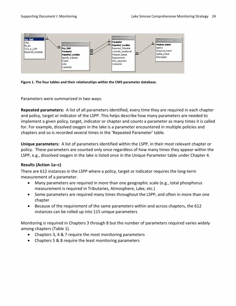
Supporting Document I: Monitoring Lake Simcoe Comprehensive Monitoring Strategy 24
Figure 1. The four tables and their relationships within the CMS parameter database.
Parameters were summarized in two ways:
Repeated parameters: A list of all parameters identified, every time they are required in each chapter and policy, target or indicator of the LSPP. This helps describe how many parameters are needed to implement a given policy, target, indicator or chapter and counts a parameter as many times it is called for. For example, dissolved oxygen in the lake is a parameter encountered in multiple policies and chapters and so is recorded several times in the ‘Repeated Parameter’ table.
Unique parameters: A list of parameters identified within the LSPP, in their most relevant chapter or policy. These parameters are counted only once regardless of how many times they appear within the LSPP, e.g., dissolved oxygen in the lake is listed once in the Unique Parameter table under Chapter 4.
Results (Action 1a–c) There are 612 instances in the LSPP where a policy, target or indicator requires the long-term measurement of a parameter.
• Many parameters are required in more than one geographic scale (e.g., total phosphorus measurement is required in Tributaries, Atmosphere, Lake, etc.)
• Some parameters are required many times throughout the LSPP, and often in more than one chapter
• Because of the requirement of the same parameters within and across chapters, the 612 instances can be rolled up into 115 unique parameters
Monitoring is required in Chapters 3 through 8 but the number of parameters required varies widely among chapters (Table 1).
• Chapters 3, 4 & 7 require the most monitoring parameters • Chapters 5 & 8 require the least monitoring parameters
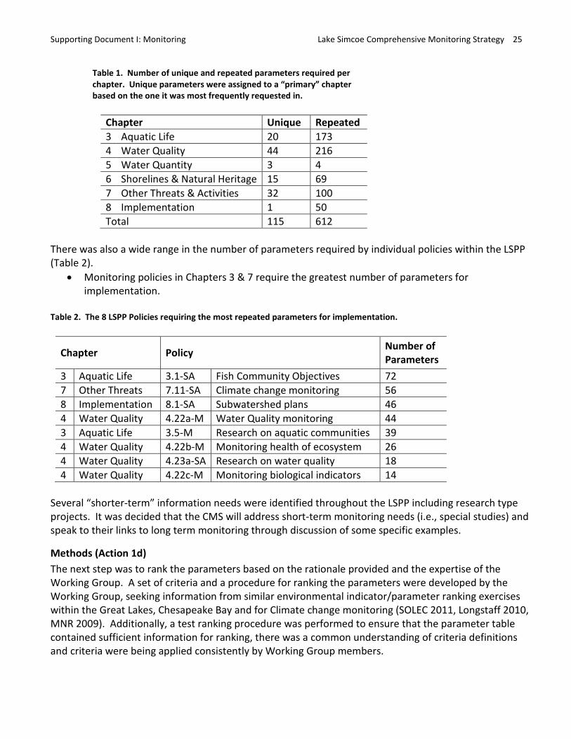
Supporting Document I: Monitoring Lake Simcoe Comprehensive Monitoring Strategy 25
Table 1. Number of unique and repeated parameters required per chapter. Unique parameters were assigned to a “primary” chapter based on the one it was most frequently requested in.
Chapter Unique Repeated3 Aquatic Life 20 173 4 Water Quality 44 216 5 Water Quantity 3 4 6 Shorelines & Natural Heritage 15 69 7 Other Threats & Activities 32 100 8 Implementation 1 50 Total 115 612
There was also a wide range in the number of parameters required by individual policies within the LSPP (Table 2).
• Monitoring policies in Chapters 3 & 7 require the greatest number of parameters for implementation.
Table 2. The 8 LSPP Policies requiring the most repeated parameters for implementation.
Chapter Policy Number of Parameters
3 Aquatic Life 3.1-SA Fish Community Objectives 72 7 Other Threats 7.11-SA Climate change monitoring 56 8 Implementation 8.1-SA Subwatershed plans 46 4 Water Quality 4.22a-M Water Quality monitoring 44 3 Aquatic Life 3.5-M Research on aquatic communities 39 4 Water Quality 4.22b-M Monitoring health of ecosystem 26 4 Water Quality 4.23a-SA Research on water quality 18 4 Water Quality 4.22c-M Monitoring biological indicators 14
Several “shorter-term” information needs were identified throughout the LSPP including research type projects. It was decided that the CMS will address short-term monitoring needs (i.e., special studies) and speak to their links to long term monitoring through discussion of some specific examples.
Methods (Action 1d) The next step was to rank the parameters based on the rationale provided and the expertise of the Working Group. A set of criteria and a procedure for ranking the parameters were developed by the Working Group, seeking information from similar environmental indicator/parameter ranking exercises within the Great Lakes, Chesapeake Bay and for Climate change monitoring (SOLEC 2011, Longstaff 2010, MNR 2009). Additionally, a test ranking procedure was performed to ensure that the parameter table contained sufficient information for ranking, there was a common understanding of criteria definitions and criteria were being applied consistently by Working Group members.
Supporting Document I: Monitoring Lake Simcoe Comprehensive Monitoring Strategy 26
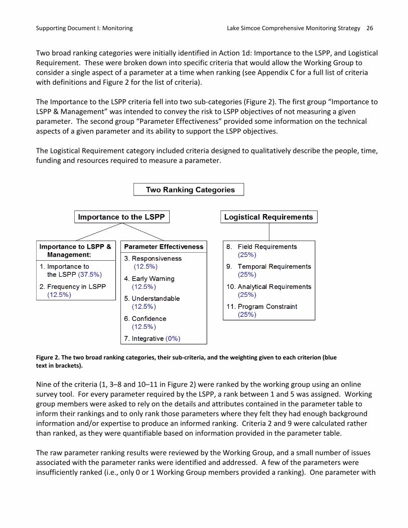
Two broad ranking categories were initially identified in Action 1d: Importance to the LSPP, and Logistical Requirement. These were broken down into specific criteria that would allow the Working Group to consider a single aspect of a parameter at a time when ranking (see Appendix C for a full list of criteria with definitions and Figure 2 for the list of criteria).
The Importance to the LSPP criteria fell into two sub-categories (Figure 2). The first group “Importance to LSPP & Management” was intended to convey the risk to LSPP objectives of not measuring a given parameter. The second group “Parameter Effectiveness” provided some information on the technical aspects of a given parameter and its ability to support the LSPP objectives.
The Logistical Requirement category included criteria designed to qualitatively describe the people, time, funding and resources required to measure a parameter.
Two Ranking Categories
Logistical Requirements Logistical Requirements
Importance to LSPP & Management:
1. Importance to the LSPP (37.5%)
2. Frequency in LSPP (12.5%)
Parameter Effectiveness
3. Responsiveness (12.5%)
4. Early Warn ing (12.5%)
5. Understandable (12.5%)
6. Confidence (12.5%)
7. Integrative (0%)
8. Field Requ irements (25%)
9. Temporal Requ irements (25%)
10. Analytical Requ irements (25%)
11. Program Constraint (25%)
Figure 2. The two broad ranking categories, their sub-criteria, and the weighting given to each criterion (blue text in brackets).
Nine of the criteria (1, 3–8 and 10–11 in Figure 2) were ranked by the working group using an online survey tool. For every parameter required by the LSPP, a rank between 1 and 5 was assigned. Working group members were asked to rely on the details and attributes contained in the parameter table to inform their rankings and to only rank those parameters where they felt they had enough background information and/or expertise to produce an informed ranking. Criteria 2 and 9 were calculated rather than ranked, as they were quantifiable based on information provided in the parameter table.
The raw parameter ranking results were reviewed by the Working Group, and a small number of issues associated with the parameter ranks were identified and addressed. A few of the parameters were insufficiently ranked (i.e., only 0 or 1 Working Group members provided a ranking). One parameter with
Supporting Document I: Monitoring Lake Simcoe Comprehensive Monitoring Strategy 27
0 rankings was removed and the other was combined with an existing parameter based on expert advice. Parameters with 1 ranking remain in the results, but are identified as less reliable. A small number of parameters had vastly divergent ranks for some criteria (i.e., ranging from 1 to 5), indicating a potential misunderstanding in criterion definition or parameter attributes. Two criteria in particular were problematic; the term Integrative apparently had different interpretations and therefore was removed, and Program Constraints was re-ranked based on the opinion of the Working Group member responsible for the monitoring of the parameter.
The median value was used to produce a single rank for each parameter for each of the 8 criteria. Next, criteria 1–6 were weighted to calculate an overall “Importance to the LSPP” ranking, and criteria 8–11 were weighted for a “Logistical Requirement” ranking. A criteria weighting system was developed by the Working Group in consultation with the CMS steering committee and members of the LSPP OMC, and were also presented to the LSSC. Each criterion was assigned a weighting value (percent weight is shown in brackets next to criteria in Figure 2) to contribute to the final two broad categories.
Results (Action 1d) Parameters have been listed in order of their Importance to the LSPP in Appendix D for each primary chapter. The LSPP, in many instances, explicitly states monitoring requirements to achieve overall plan objectives (e.g., Monitoring “M”- policies) while other monitoring requirements may support Designated Policy or Strategic Action Policy implementation. Those parameters that ranked high Importance to LSPP could be interpreted as a priority based on their ability to implement the policies of the LSPP and monitor its success.
Another potential way of supporting decision making is to use both the Logistical Requirements and Importance to LSPP criteria to facilitate a risk-based approach for prioritizing parameters. The graph below indicates the relative importance of the criteria outlined for each parameter (Figure 3). This could assist with management decision making, but should be considered within the context of the LSPP as a prioritization exercise. For example, a parameter that has high Importance and low Logistical Requirements could be seen as a priority for implementation due to its low resource requirements.
Supporting Document I: Monitoring Lake Simcoe Comprehensive Monitoring Strategy 28
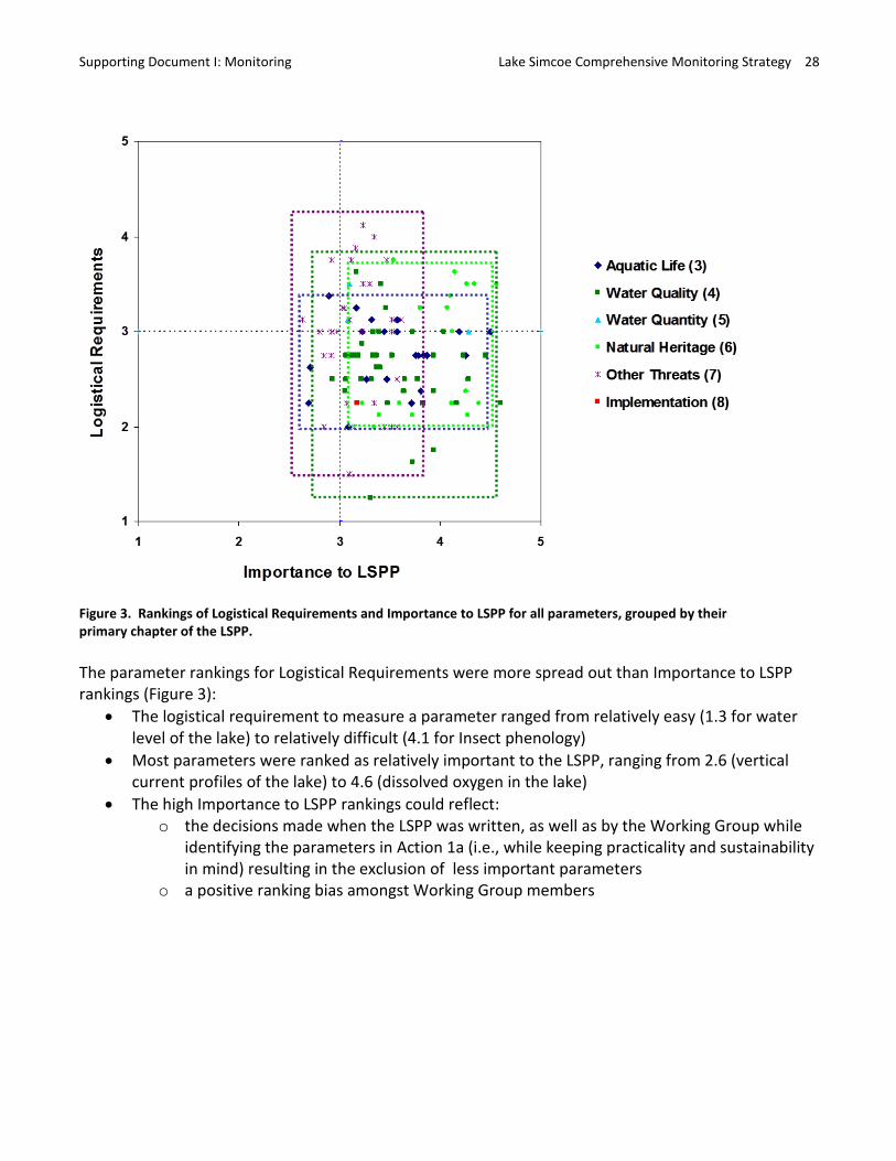
Figure 3. Rankings of Logistical Requirements and Importance to LSPP for all parameters, grouped by their primary chapter of the LSPP.
The parameter rankings for Logistical Requirements were more spread out than Importance to LSPP rankings (Figure 3):
• The logistical requirement to measure a parameter ranged from relatively easy (1.3 for water level of the lake) to relatively difficult (4.1 for Insect phenology)
• Most parameters were ranked as relatively important to the LSPP, ranging from 2.6 (vertical current profiles of the lake) to 4.6 (dissolved oxygen in the lake)
• The high Importance to LSPP rankings could reflect: o the decisions made when the LSPP was written, as well as by the Working Group while
identifying the parameters in Action 1a (i.e., while keeping practicality and sustainability in mind) resulting in the exclusion of less important parameters
o a positive ranking bias amongst Working Group members
Supporting Document I: Monitoring Lake Simcoe Comprehensive Monitoring Strategy 29
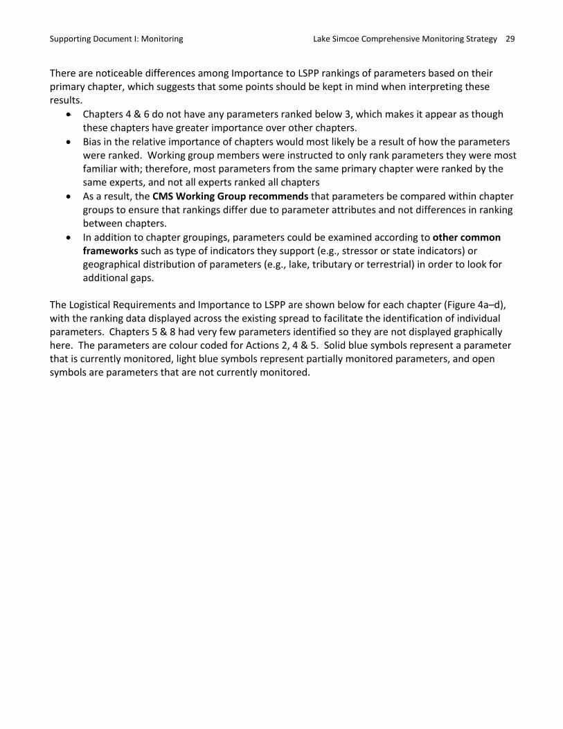
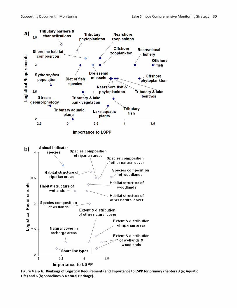
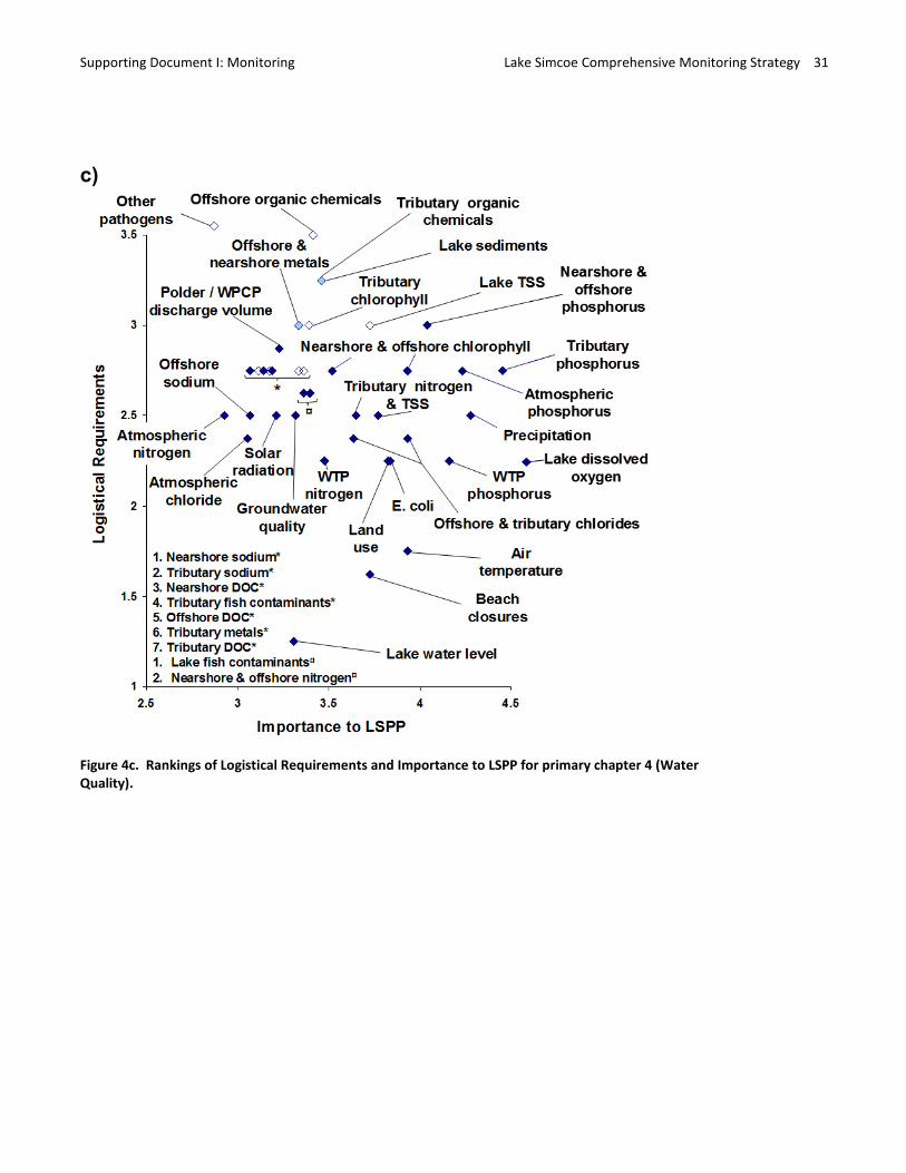
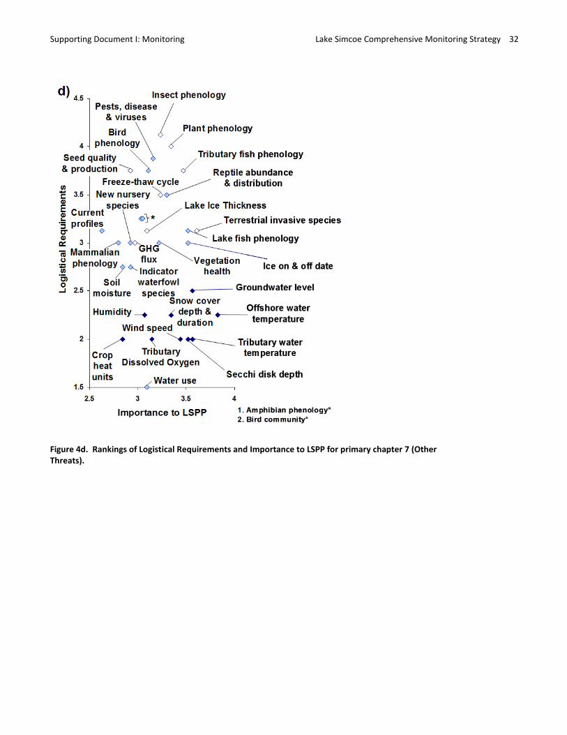
There are noticeable differences among Importance to LSPP rankings of parameters based on their primary chapter, which suggests that some points should be kept in mind when interpreting these results.
• Chapters 4 & 6 do not have any parameters ranked below 3, which makes it appear as though these chapters have greater importance over other chapters.
• Bias in the relative importance of chapters would most likely be a result of how the parameters were ranked. Working group members were instructed to only rank parameters they were most familiar with; therefore, most parameters from the same primary chapter were ranked by the same experts, and not all experts ranked all chapters
• As a result, the CMS Working Group recommends that parameters be compared within chapter groups to ensure that rankings differ due to parameter attributes and not differences in ranking between chapters.
• In addition to chapter groupings, parameters could be examined according to other common frameworks such as type of indicators they support (e.g., stressor or state indicators) or geographical distribution of parameters (e.g., lake, tributary or terrestrial) in order to look for additional gaps.
The Logistical Requirements and Importance to LSPP are shown below for each chapter (Figure 4a–d), with the ranking data displayed across the existing spread to facilitate the identification of individual parameters. Chapters 5 & 8 had very few parameters identified so they are not displayed graphically here. The parameters are colour coded for Actions 2, 4 & 5. Solid blue symbols represent a parameter that is currently monitored, light blue symbols represent partially monitored parameters, and open symbols are parameters that are not currently monitored.
Supporting Document I: Monitoring Lake Simcoe Comprehensive Monitoring Strategy 30
Figure 4 a & b. Rankings of Logistical Requirements and Importance to LSPP for primary chapters 3 (a; Aquatic Life) and 6 (b; Shorelines & Natural Heritage).
Supporting Document I: Monitoring Lake Simcoe Comprehensive Monitoring Strategy 31
Figure 4c. Rankings of Logistical Requirements and Importance to LSPP for primary chapter 4 (Water Quality).
c)
Supporting Document I: Monitoring Lake Simcoe Comprehensive Monitoring Strategy 32
Figure 4d. Rankings of Logistical Requirements and Importance to LSPP for primary chapter 7 (Other Threats).
Supporting Document I: Monitoring Lake Simcoe Comprehensive Monitoring Strategy 33
Some exclusions and additional considerations: One parameter that was identified by the Working Group was not included in the ranking process; Policy 4.11-DP requires stormwater management operators to monitor stormwater influent and effluent from stormwater works. The Working Group elected not to rank this parameter because its implementation was not a responsibility of this group, and therefore considered outside of the scope of the CMS.
Actions 1 a–c identified several parameters required by the LSPP that are currently monitored outside the purview of the LSPP/LSPA. In the CMS, we will dedicate a section to these parameters highlighting our dependence on their measurement and how monitoring and the LSPP would be impacted if their collection were to be terminated.
Action 2: Characterize the current state of Monitoring in Lake Simcoe
Action 2 called for an inventory of ecological and environmental monitoring that is underway in the Lake and watershed in support of the LSPP. This inventory was to be completed at the parameter level, similar to the approach taken in Action 1. As part of this inventory, the Working Group was asked to identify the monitoring program and agency responsible for measuring parameters as well as spatial and temporal coverage of the parameters.
Methods (Action 2) While reviewing the LSPP for Action 1, Working Group members also identified whether a parameter was being monitored and if so, identified the name of the program, the agency responsible, and the program’s spatial and temporal extent. Based on their expert opinion, and keeping practicality and sustainability in mind, the Working Group also identified whether the parameter was being monitored to an extent that satisfied LSPP policies/targets/indicators. A “Yes” was indicated in the database for parameters that would, and “Partial” was written for those that would not. Partially implemented parameters may have been conducted on a trial or research basis only, or not conducted with adequate temporal or spatial resolution to support full policy/target/indicator implementation.
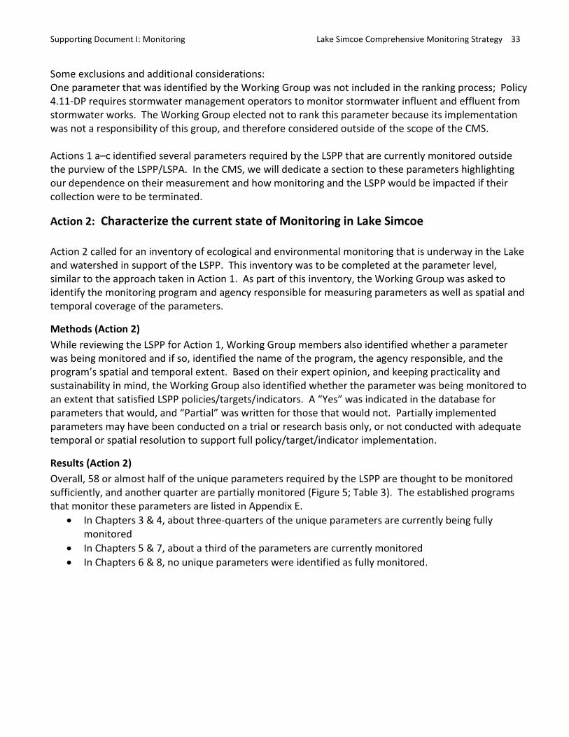
Results (Action 2) Overall, 58 or almost half of the unique parameters required by the LSPP are thought to be monitored sufficiently, and another quarter are partially monitored (Figure 5; Table 3). The established programs that monitor these parameters are listed in Appendix E.
• In Chapters 3 & 4, about three-quarters of the unique parameters are currently being fully monitored
• In Chapters 5 & 7, about a third of the parameters are currently monitored • In Chapters 6 & 8, no unique parameters were identified as fully monitored.
Supporting Document I: Monitoring Lake Simcoe Comprehensive Monitoring Strategy 34
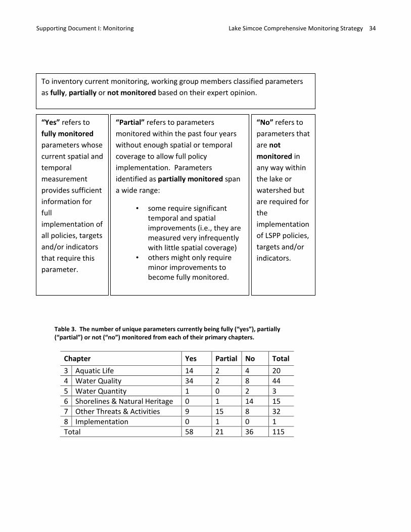
To inventory current monitoring, working group members classified parameters as fully, partially or not monitored based on their expert opinion.
“Yes” refers to fully monitored parameters whose current spatial and temporal measurement provides sufficient information for full implementation of all policies, targets and/or indicators that require this parameter.
“Partial” refers to parameters monitored within the past four years without enough spatial or temporal coverage to allow full policy implementation. Parameters identified as partially monitored span a wide range:
• some require significanttemporal and spatialimprovements (i.e., they aremeasured very infrequentlywith little spatial coverage)
• others might only requireminor improvements tobecome fully monitored.
“No” refers to parameters that are not monitored in any way within the lake or watershed but are required for the implementation of LSPP policies, targets and/or indicators.
Table 3. The number of unique parameters currently being fully (“yes”), partially (“partial”) or not (“no”) monitored from each of their primary chapters.
Chapter Yes Partial No Total3 Aquatic Life 14 2 4 20 4 Water Quality 34 2 8 44 5 Water Quantity 1 0 2 3 6 Shorelines & Natural Heritage 0 1 14 15 7 Other Threats & Activities 9 15 8 32 8 Implementation 0 1 0 1 Total 58 21 36 115
Supporting Document I: Monitoring Lake Simcoe Comprehensive Monitoring Strategy 35
Figure 5. The percent of unique parameters currently being fully (“yes”), partially (“partial”) or not (“no”) monitored from each of their primary chapters in the LSPP.
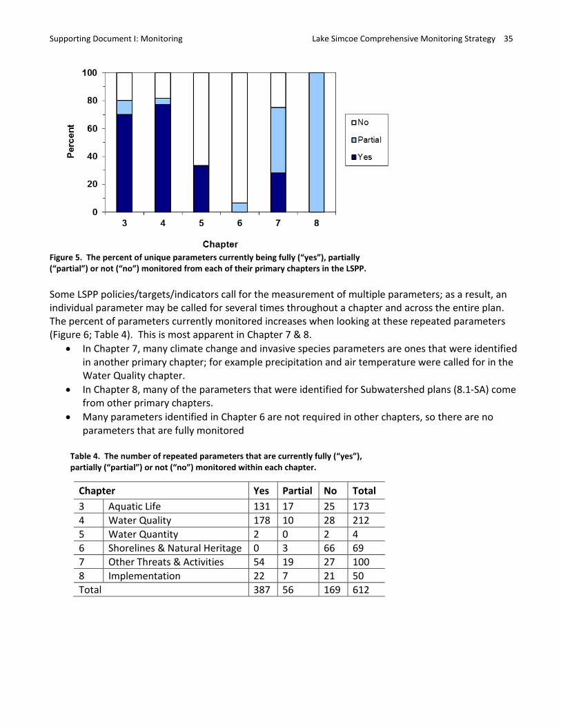
Some LSPP policies/targets/indicators call for the measurement of multiple parameters; as a result, an individual parameter may be called for several times throughout a chapter and across the entire plan. The percent of parameters currently monitored increases when looking at these repeated parameters (Figure 6; Table 4). This is most apparent in Chapter 7 & 8.
• In Chapter 7, many climate change and invasive species parameters are ones that were identified in another primary chapter; for example precipitation and air temperature were called for in the Water Quality chapter.
• In Chapter 8, many of the parameters that were identified for Subwatershed plans (8.1-SA) come from other primary chapters.
• Many parameters identified in Chapter 6 are not required in other chapters, so there are no parameters that are fully monitored
Table 4. The number of repeated parameters that are currently fully (“yes”), partially (“partial”) or not (“no”) monitored within each chapter.
Chapter Yes Partial No Total 3 Aquatic Life 131 17 25 173 4 Water Quality 178 10 28 212 5 Water Quantity 2 0 2 4 6 Shorelines & Natural Heritage 0 3 66 69 7 Other Threats & Activities 54 19 27 100 8 Implementation 22 7 21 50 Total 387 56 169 612
Supporting Document I: Monitoring Lake Simcoe Comprehensive Monitoring Strategy 36
Figure 6. The percent of repeated parameters currently being fully (“yes”), partially (“partial”) or not (“no”) monitored from each of their primary chapters in the LSPP.
Action 3: Identify monitoring overlap and duplication among partner agencies The work completed for Action 2 documented an extensive suite of ongoing monitoring that measures parameters required throughout the LSPP. Action 3 builds on these findings, requiring the identification of duplication and overlap between agencies in their respective monitoring work. To evaluate the ongoing monitoring for overlap and duplication, Action 3 called for consideration of spatial coverage, methodology and purpose of parameter measurement.
Methods (Action 3) A starting assumption of the Working Group was that overlap and duplication referred to the same thing, thus work on Action 3 was referred to solely as overlap. We defined overlap as cases where the same data was gathered in similar areas, at similar spatial and temporal scales and for fundamentally similar purposes by different agencies. The database table identifying Program Names was examined, as it identified monitoring programs collecting the same parameters in similar areas of the lake or watershed. Programs collecting similar parameters were discussed with the Working Group to understand the nature of apparent areas of overlap.
Results (Action 3) Apparent overlap in monitoring programs was observed in 4 possible cases:
1. Benthic invertebrate community monitoring in the Lake 2. Hydrometric monitoring in the watershed 3. Lake water quality monitoring in the Holland River 4. Large scale and site level terrestrial natural heritage monitoring in the watershed
Working group discussions led by agency experts with knowledge of the 4 cases revealed the following details and conclusions on apparent overlap: 1. Ministry of Natural Resources conducted benthic invertebrate community research on Lake Simcoe
from 1980–2009. Research objectives of this work were to test hypotheses about the effects of
Supporting Document I: Monitoring Lake Simcoe Comprehensive Monitoring Strategy 37
invasive species on water quality changes. Given the long time span over which the information was collected, this research has served the function of monitoring to track the state and trend of the community. This work has now ended and is being reported through primary literature. The Lake Simcoe Region Conservation Authority (LSRCA) recently began monitoring (2008/09) the Lake’s benthic invertebrate community as part of its nearshore and offshore monitoring programs.
Conclusion: This work does not represent overlap as the programs occurred over different time periods and for different purposes. One of the programs has ended permanently and the other began shortly thereafter.
2. Hydrometric monitoring is conducted on many tributaries in the Lake Simcoe watershed by Environment Canada and MOE/LSRCA (Appendix E). These programs measure information for calculating tributary flow, which is a critical variable in lake phosphorus load estimations performed by MOE/LSRCA. Given the variation in flow among tributaries, information is required from as many tributaries as possible for accurate load estimations.
Conclusion: This work does not constitute overlap. While similar hydrometric information is measured by 2 different agencies, it is done on different tributaries thus is complimentary for MOE/LSRCA’s analysis of P-loads. This work represents a positive collaboration amongst agencies to support a relatively resource intensive need.
3. Lake water quality monitoring on the Holland River is carried out by both LSRCA and MOE/LSRCA. The MOE/LSRCA has been monitoring at 3 Holland River stations since the 1980s as part of their long-term water quality monitoring program: one just near the mouth of the river and one each at the confluence of the East and West Holland River. The LSRCA monitors water quality at 8 Holland River stations as part of their nearshore monitoring program with the purpose to compare to sediment chemistry and examine Phoslock applications. These 8 monitoring stations also do not over lap with the MOE/LSRCA’s, as they are further upstream.
Conclusion: There is neither an overlap in spatial location or purpose of the water quality monitoring by MOE and MOE/LSRCA on the Holland River.
4. The large scale monitoring of terrestrial natural heritage parameters starting with “Extent and distribution” uses remote sensing and GIS interpretation to determine the distribution of various habitat types including grasslands, wetlands, woodlands, and forested valleylands and riparian areas. Site level monitoring of parameters starting with “Habitat Structure” and “Species composition” directly measures vegetation types in the aforementioned habitat types. Some of these parameters appear to have been partially measured by both the Ministry of Natural Resources (MNR) and the LSRCA within the watershed. However, it is important to note that there are no (0) fully monitored terrestrial natural heritage parameters. Some of this “partial” monitoring is opportunistically implemented and thus a long way from being temporally and spatially adequate to fully address monitoring needs. These agencies have recently agreed on non-overlapping monitoring responsibilities and to a common methodology for the partially implemented monitoring.
Supporting Document I: Monitoring Lake Simcoe Comprehensive Monitoring Strategy 38
Conclusion: This work does not represent overlap as monitoring occurred insufficiently to meet LSPP needs and recent agreements have set out (1) non-overlapping monitoring responsibilities and (2) common data collection methodologies.
Overall, the Working Group found that LSPP related monitoring on the lake and in the watershed is well co-ordinated. In all cases, current fully or partially implemented monitoring (identified in Action 2) is unique and not duplicated. Additionally, work on Action 3 found several areas of collaboration and co-operation where two or more programs or agencies contribute resources towards meeting a common monitoring objective without overlap.
Action 4: Identify monitoring gaps This Action called for the identification of parameters that were not currently being monitored or not currently being monitored at the scale or frequency required by the LSPP.
Methods (Action 4) This Action followed from the results of Action 2, where the list of parameters that are fully or partially monitored were identified. Parameters called for by the LSPP that were either not monitored or partially monitored were deemed by the working group to constitute a gap and were considered in Action 4 & 5.
Results (Action 4) Parameters that are called for in the LSPP but were not currently considered monitored make up about a third of the unique parameters identified; however, this is not distributed evenly across all primary chapters (Table 3 & Figure 5 above). In particular, 93% are not currently monitored in chapter 6 while in chapters 3, 4 & 7, between a fifth and a quarter of the parameters identified in the LSPP are not currently monitored.
About one fifth of the unique parameters were considered partially monitored (Table 3 & Figure 5 above), with very few (5–10%) in chapters 3, 4 & 6 and 47% in chapter 7. In Chapter 8, the only unique parameter identified (soil phosphorus in the Holland Marsh) is partially monitored through a recent LSCUF research project
It is important to remember that the extent to which a parameter is partially monitored can vary quite substantially. Some parameters labelled partially monitored might only need small improvements in spatial and/or temporal scale while others may need substantial improvements.
Supporting Document I: Monitoring Lake Simcoe Comprehensive Monitoring Strategy 39
Action 5: Recommend additional monitoring to fill gaps Action 5 called for recommendations to be made for filling monitoring gaps.
Methods (Action 5) Parameters that are gaps (i.e., not monitored or only partially monitored) were identified in Action 4. These gaps, along with their ranking results, were used by the working group to identify recommendations based on a cost-effective program approach. This approach assumed that a monitoring program could collect multiple samples on the same sampling trip thus increasing efficiency and making implementation of gap filling more feasible. A program was defined as any monitoring work occurring out in the field (on the lake, tributaries or in watershed), and excluded any analytical and/or lab requirements. The working group provided professional input on how best to:
1. Group priority gap parameters into monitoring programs by: a. designing new programs that included many parameters b. adding parameters to or enhancing existing monitoring programs c. coordinating existing external programs rather than starting new programs d. reclassifying some gaps as research rather than monitoring, given the infrequency of data
collection 2. Prioritize programs that were identified in (1)
Monitoring recommendations were developed from the results of this analysis.
Results (Action 5) Thirty eight of the 58 gap parameters were grouped into existing or new programs, and many of these gap parameters had very high importance to the LSPP (Appendix F). The working group prioritized the programs according to Table 5, with two new terrestrial monitoring programs as top priorities. When the rank in importance to Plan of the gap parameters was averaged within programs, these two terrestrial programs also came out on top (2nd column of Table 5), reinforcing the importance of implementing these programs.
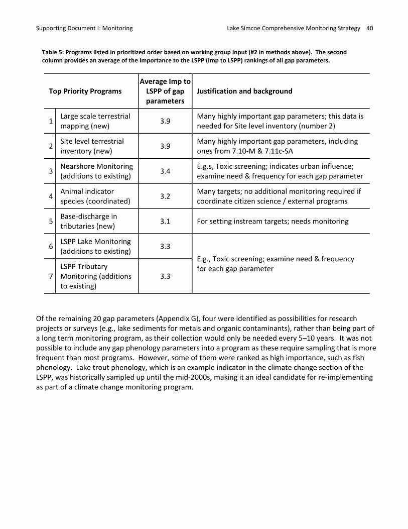
Supporting Document I: Monitoring Lake Simcoe Comprehensive Monitoring Strategy 40
Table 5: Programs listed in prioritized order based on working group input (#2 in methods above). The second column provides an average of the Importance to the LSPP (Imp to LSPP) rankings of all gap parameters.
Top Priority Programs Average Imp to
LSPP of gap parameters
Justification and background
1 Large scale terrestrial mapping (new) 3.9 Many highly important gap parameters; this data is
needed for Site level inventory (number 2)
2 Site level terrestrial inventory (new) 3.9 Many highly important gap parameters, including
ones from 7.10-M & 7.11c-SA
3 Nearshore Monitoring (additions to existing) 3.4 E.g.s, Toxic screening; indicates urban influence;
examine need & frequency for each gap parameter
4 Animal indicator species (coordinated) 3.2 Many targets; no additional monitoring required if
coordinate citizen science / external programs
5 Base-discharge in tributaries (new) 3.1 For setting instream targets; needs monitoring
6 LSPP Lake Monitoring (additions to existing) 3.3
E.g., Toxic screening; examine need & frequency for each gap parameter
7 LSPP Tributary Monitoring (additions to existing)
3.3
Of the remaining 20 gap parameters (Appendix G), four were identified as possibilities for research projects or surveys (e.g., lake sediments for metals and organic contaminants), rather than being part of a long term monitoring program, as their collection would only be needed every 5–10 years. It was not possible to include any gap phenology parameters into a program as these require sampling that is more frequent than most programs. However, some of them were ranked as high importance, such as fish phenology. Lake trout phenology, which is an example indicator in the climate change section of the LSPP, was historically sampled up until the mid-2000s, making it an ideal candidate for re-implementing as part of a climate change monitoring program.
Supporting Document I: Monitoring Lake Simcoe Comprehensive Monitoring Strategy 41
References:
Bertram P, and Stadler-Salt N. 2000. Selection of Indicators for Great Lakes Basin Ecosystem Health, Version 4. State of the Lakes Ecosystem Conference, March 2000. http://www.epa.gov/solec/archive/2000/Selection_of_Indicators_Version_4_%28FULL%29.pdf
Longstaff BJ, Carruthers TJB, Dennison WC, Lookingbill TR, Hawkey JM, Thomas JE, Wicks EC, Woerner JL (eds) Integrating and Applying Science: A handbook for effective coastal ecosystem assessment. IAN Press, Cambridge, MD, p 167–186.
MNR, Science & Information Section, Science & Information Branch. 2011. A proposal for an integrated climate change monitoring program to inform decision making and model the impacts of climate change in the Lake Simcoe watershed. Internal report prepared for The Lake Simcoe Project, Ministry of Environment.
Supporting Document I: Monitoring Lake Simcoe Comprehensive Monitoring Strategy 42
Appendix A Current LS CMS Steering Committee and Working Group Members and their Affiliations
Role Name Affiliation Steering Committee Rachael Fletcher EMRB, MOECC Steering Committee Dan Orr CR, MOECC Steering Committee Cam Willox SIB, MNRF Working Group Co-chair Joelle Young EMRB, MOECC Working Group Co-chair Jake La Rose SIB, MNRF Working Group Member Silvia Strobl SIB, MNRF Working Group Member Darryl Finnigan MAFRA Working Group Member Veronique Hiriart-Baer EC Working Group Member Rebecca Dolson SIB, MNRF Working Group Member David Evans ARDB, MNRF Working Group Member Bruce Pond ARDB, MNRF Working Group Member Tim Krsul CR, MOECC Working Group Member David Lembcke LSRCA Working Group Member Ben Longstaff LSRCA Working Group Member Kate Gee ROD, MNRF Working Group Member Emily Funnell ROD, MNRF Working Group Member Pilar Hernandez ROD, MNRF Working Group Member Jennifer Winter EMRB, MOECC Working Group Member Michelle Palmer EMRB, MOECC Working Group Member Danijela Puric-Mladenovic SIB, MNRF

Supporting Document I: Monitoring Lake Simcoe Comprehensive Monitoring Strategy 43
Appendix B Attributes that were identified for each parameter (when possible) and their definitions.
1. Chapter – Chapter of the LSPP containing the parameter requirement 2. LSPP Page number – page number containing the parameter requirement 3. Key field – Policy number or unique identifier for the indicator or target. 4. LSPP Indicator/Target/Policy name – A name assigned by the Working Group to a particular
indicator target or policy 5. Directly links to – Can include (optional) any other targets/indicators/policies that link strongly to
the target/indicator/policy 6. Indicate explicit or implicit need – identifies whether need for parameter is explicitly or implicitly
identified in the LSPP 7. Parameter name – Identify key parameter(s) that need to be monitored for the
target/indicator/policy. If there is a lack of specificity, use your expert opinion in identifying the most important parameters to implementing the policy.
8. Reported Schedule – Indicates the time period over which the parameter needs to be summarized when reporting results to a broad audience
9. Reported Location – Indicates the spatial area across which the parameter is summarized when reporting results to a broad audience
10. Currently monitored – Yes/no/partial as of 2011/12 11. Agency(s) – Names of agencies measuring the parameters 12. Temporal extent – Where this parameter is monitored 13. Spatial extent – Provides additional information about where parameter is monitored at all
appropriate scale(s) (e.g., number of stations/quadrants, location, etc). 14. Name of program(s) – Name of monitoring program 15. Logistical Requirements – a high level description of logistical requirements in field, lab or
computation 16. Why is this important? – Rationale for why monitoring is important, and/or what the
implications would be if not monitored. If the parameter is implicit, must establish the link to the target/indicator/policy
17. Comments – additional information that did not fit in above fields
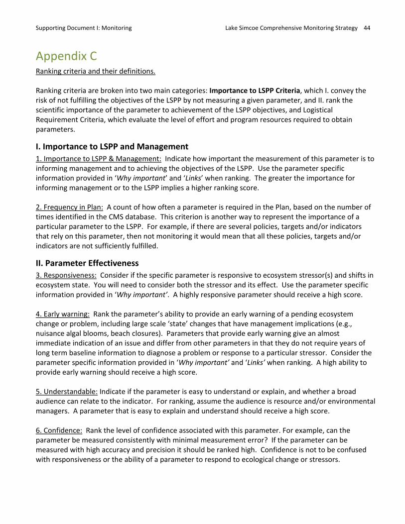
Supporting Document I: Monitoring Lake Simcoe Comprehensive Monitoring Strategy 44
Appendix C Ranking criteria and their definitions.
Ranking criteria are broken into two main categories: Importance to LSPP Criteria, which I. convey the risk of not fulfilling the objectives of the LSPP by not measuring a given parameter, and II. rank the scientific importance of the parameter to achievement of the LSPP objectives, and Logistical Requirement Criteria, which evaluate the level of effort and program resources required to obtain parameters.
I. Importance to LSPP and Management 1. Importance to LSPP & Management: Indicate how important the measurement of this parameter is to informing management and to achieving the objectives of the LSPP. Use the parameter specific information provided in ‘Why important’ and ‘Links’ when ranking. The greater the importance for informing management or to the LSPP implies a higher ranking score.
2. Frequency in Plan: A count of how often a parameter is required in the Plan, based on the number of times identified in the CMS database. This criterion is another way to represent the importance of a particular parameter to the LSPP. For example, if there are several policies, targets and/or indicators that rely on this parameter, then not monitoring it would mean that all these policies, targets and/or indicators are not sufficiently fulfilled.
II. Parameter Effectiveness 3. Responsiveness: Consider if the specific parameter is responsive to ecosystem stressor(s) and shifts in ecosystem state. You will need to consider both the stressor and its effect. Use the parameter specific information provided in ‘Why important’. A highly responsive parameter should receive a high score.
4. Early warning: Rank the parameter’s ability to provide an early warning of a pending ecosystem change or problem, including large scale ‘state’ changes that have management implications (e.g., nuisance algal blooms, beach closures). Parameters that provide early warning give an almost immediate indication of an issue and differ from other parameters in that they do not require years of long term baseline information to diagnose a problem or response to a particular stressor. Consider the parameter specific information provided in ‘Why important’ and ‘Links’ when ranking. A high ability to provide early warning should receive a high score.
5. Understandable: Indicate if the parameter is easy to understand or explain, and whether a broad audience can relate to the indicator. For ranking, assume the audience is resource and/or environmental managers. A parameter that is easy to explain and understand should receive a high score.
6. Confidence: Rank the level of confidence associated with this parameter. For example, can the parameter be measured consistently with minimal measurement error? If the parameter can be measured with high accuracy and precision it should be ranked high. Confidence is not to be confused with responsiveness or the ability of a parameter to respond to ecological change or stressors.

Supporting Document I: Monitoring Lake Simcoe Comprehensive Monitoring Strategy 45
7. Integrative: Indicate whether the parameter integrates across ecosystem components, functions and/or stressors, and over small or large time periods and/or spatial scales (subwatershed vs. whole lake). If a parameter provides information on a range of potential ecosystem components (e.g., temperature, DO, turbidity), long timescales and/or across locations, it should receive a high score. If it only provides information for a single component, covers a small period and/or spatial scale, it should receive a low score. NOTE: We have removed this criterion as the Working Group had opposing interpretations of it (i.e., rankings for individual parameters ranged from 1 to 5).
8. Field Requirement: Indicate the level of effort required by field work related to measuring a parameter. Consider if this parameter needs to be monitored at multiple sites (e.g., ecotones, sites, stations or quadrants), and/or whether there are large equipment or personnel requirements. Consider the parameter specific information provided in ‘Requirements’ and ‘Spatial extent’ fields of the CMS table. A parameter with higher field requirements should receive a higher ranking score. Do not include consideration of the temporal extent in your ranking, as this will be calculated later.
9. Temporal Requirement: Frequency required to sample the parameter (or maintain) at a single site. This was calculated using the table below with “Crew Days / year / site” = the number of days per year required for a field crew to sample or maintain (e.g., data-loggers) a single site/location.
Score Crew days / year / site Rationale 1 < 1 < once a year 2 1 to 5 1-5 / year 3 12 to 24 1-2 / month 4 50 to 100 1-2 / week 5 130 to 365 0.5-1 / day
10. Analytical Requirement: Indicate the level of analysis required to obtain each parameter. To generate the data for a parameter, is extensive laboratory or computational analyses required? A parameter with higher analytical requirements should receive a higher ranking score. Consider the information provided in ‘Requirements’ and ‘Spatial extent’ fields of the CMS table.
11. Program Constraint: The effort required to link or combine measurement of this parameter with an existing monitoring program.
Score Rationale 1 already part of an ongoing monitoring program 2 can be combined with ongoing program, adding very little
additional effort 3 can be combined with ongoing program but would require
increases in sites, personnel, time and/or equipment 4 5 cannot be combined with an ongoing monitoring program
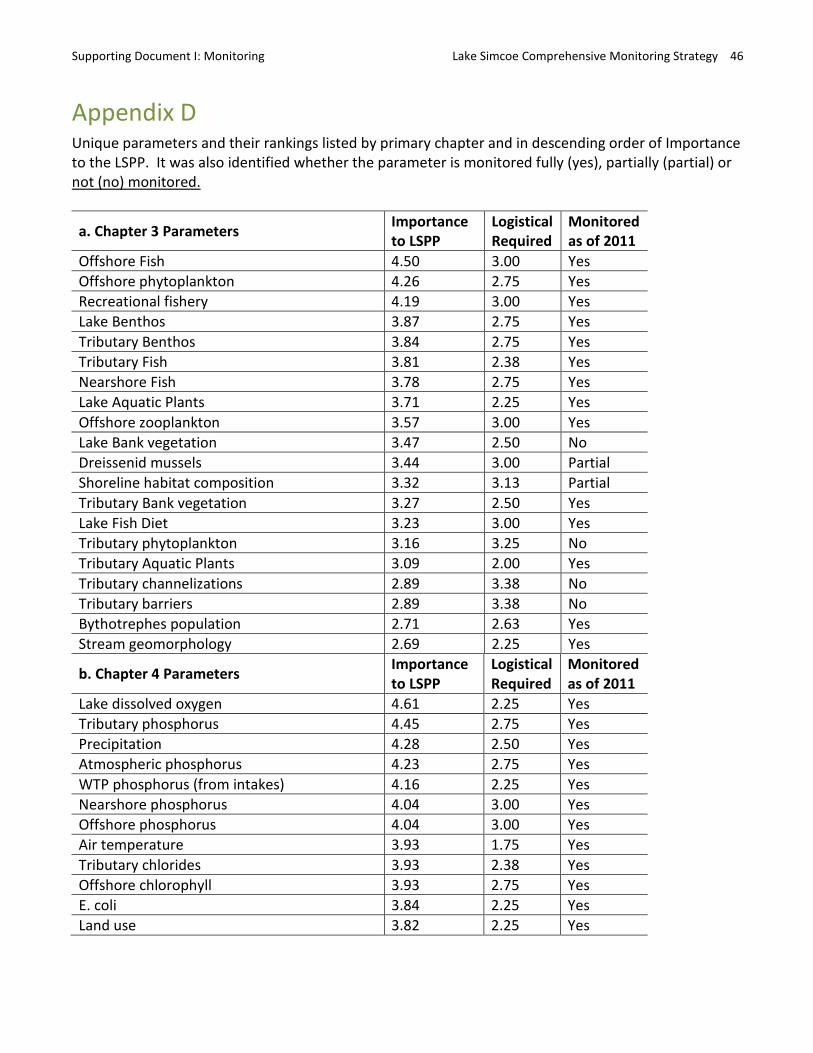
Supporting Document I: Monitoring Lake Simcoe Comprehensive Monitoring Strategy 46
Importanceto LSPP
Logistical Required
Monitored as of 2011
Appendix D Unique parameters and their rankings listed by primary chapter and in descending order of Importance to the LSPP. It was also identified whether the parameter is monitored fully (yes), partially (partial) or not (no) monitored.
a. Chapter 3 Parameters Importance to LSPP
Logistical Required
Monitored as of 2011
Offshore Fish 4.50 3.00 Yes Offshore phytoplankton 4.26 2.75 Yes Recreational fishery 4.19 3.00 Yes Lake Benthos 3.87 2.75 Yes Tributary Benthos 3.84 2.75 Yes Tributary Fish 3.81 2.38 Yes Nearshore Fish 3.78 2.75 Yes Lake Aquatic Plants 3.71 2.25 Yes Offshore zooplankton 3.57 3.00 Yes Lake Bank vegetation 3.47 2.50 No Dreissenid mussels 3.44 3.00 Partial Shoreline habitat composition 3.32 3.13 Partial Tributary Bank vegetation 3.27 2.50 Yes Lake Fish Diet 3.23 3.00 Yes Tributary phytoplankton 3.16 3.25 No Tributary Aquatic Plants 3.09 2.00 Yes Tributary channelizations 2.89 3.38 No Tributary barriers 2.89 3.38 No Bythotrephes population 2.71 2.63 Yes Stream geomorphology 2.69 2.25 Yes
b. Chapter 4 Parameters
Lake dissolved oxygen 4.61 2.25 Yes Tributary phosphorus 4.45 2.75 Yes Precipitation 4.28 2.50 Yes Atmospheric phosphorus 4.23 2.75 Yes WTP phosphorus (from intakes) 4.16 2.25 Yes Nearshore phosphorus 4.04 3.00 Yes Offshore phosphorus 4.04 3.00 Yes Air temperature 3.93 1.75 Yes Tributary chlorides 3.93 2.38 Yes Offshore chlorophyll 3.93 2.75 Yes E. coli 3.84 2.25 Yes Land use 3.82 2.25 Yes
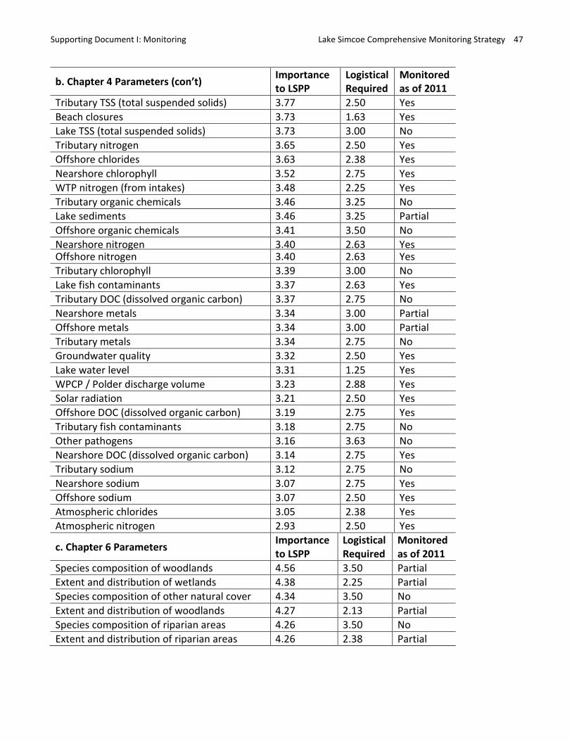
Importance Logistical Monitored to LSPP Required as of 2011
Supporting Document I: Monitoring Lake Simcoe Comprehensive Monitoring Strategy 47
b. Chapter 4 Parameters (con’t) Importance to LSPP
Logistical Required
Monitored as of 2011
Tributary TSS (total suspended solids) 3.77 2.50 Yes Beach closures 3.73 1.63 Yes Lake TSS (total suspended solids) 3.73 3.00 No Tributary nitrogen 3.65 2.50 Yes Offshore chlorides 3.63 2.38 Yes Nearshore chlorophyll 3.52 2.75 Yes WTP nitrogen (from intakes) 3.48 2.25 Yes Tributary organic chemicals 3.46 3.25 No Lake sediments 3.46 3.25 Partial Offshore organic chemicals 3.41 3.50 No Nearshore nitrogen 3.40 2.63 Yes Offshore nitrogen 3.40 2.63 Yes Tributary chlorophyll 3.39 3.00 No Lake fish contaminants 3.37 2.63 Yes Tributary DOC (dissolved organic carbon) 3.37 2.75 No Nearshore metals 3.34 3.00 Partial Offshore metals 3.34 3.00 Partial Tributary metals 3.34 2.75 No Groundwater quality 3.32 2.50 Yes Lake water level 3.31 1.25 Yes WPCP / Polder discharge volume 3.23 2.88 Yes Solar radiation 3.21 2.50 Yes Offshore DOC (dissolved organic carbon) 3.19 2.75 Yes Tributary fish contaminants 3.18 2.75 No Other pathogens 3.16 3.63 No Nearshore DOC (dissolved organic carbon) 3.14 2.75 Yes Tributary sodium 3.12 2.75 No Nearshore sodium 3.07 2.75 Yes Offshore sodium 3.07 2.50 Yes Atmospheric chlorides 3.05 2.38 Yes Atmospheric nitrogen 2.93 2.50 Yes
c. Chapter 6 Parameters
Species composition of woodlands 4.56 3.50 Partial Extent and distribution of wetlands 4.38 2.25 Partial Species composition of other natural cover 4.34 3.50 No Extent and distribution of woodlands 4.27 2.13 Partial Species composition of riparian areas 4.26 3.50 No Extent and distribution of riparian areas 4.26 2.38 Partial
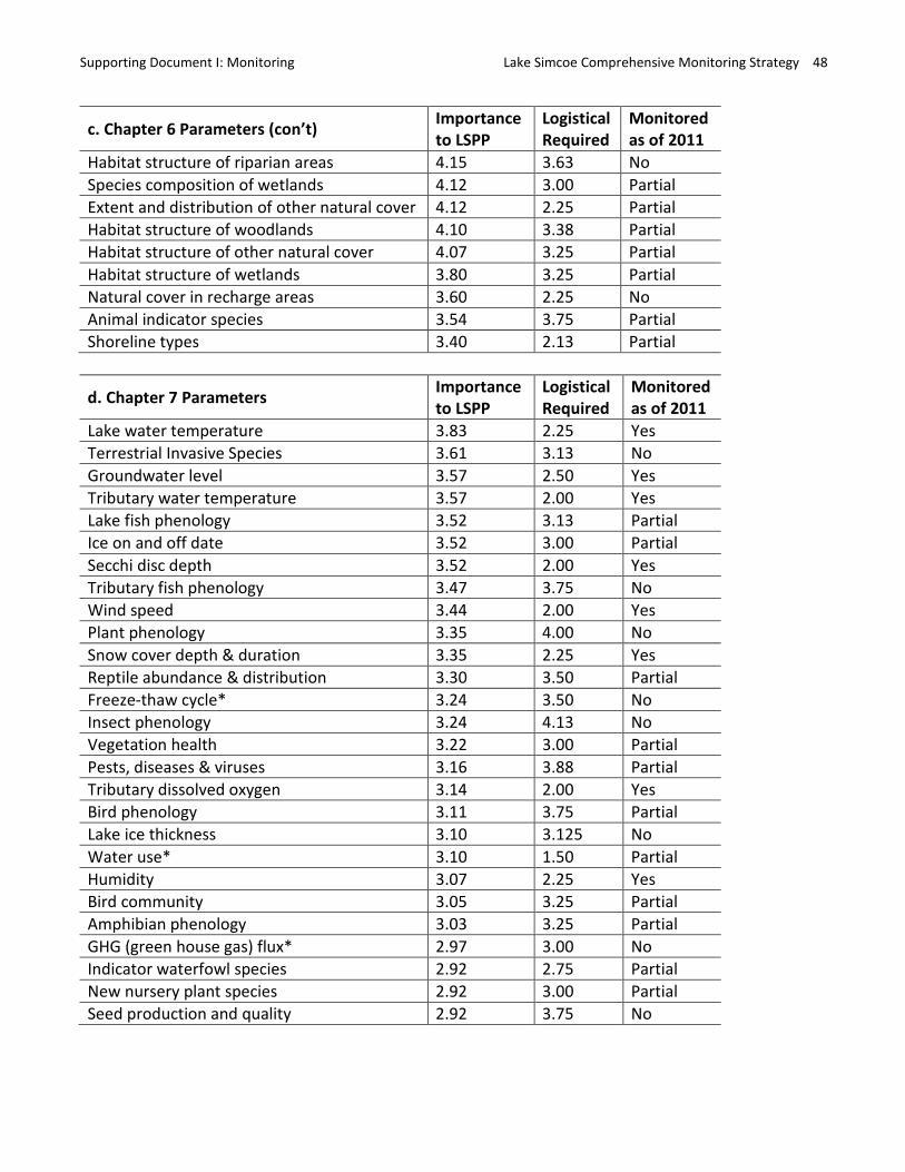
Supporting Document I: Monitoring Lake Simcoe Comprehensive Monitoring Strategy 48
c. Chapter 6 Parameters (con’t) Importance to LSPP
Logistical Required
Monitored as of 2011
Importance to LSPP
Logistical Required
Monitored as of 2011
Habitat structure of riparian areas 4.15 3.63 No Species composition of wetlands 4.12 3.00 Partial Extent and distribution of other natural cover 4.12 2.25 Partial Habitat structure of woodlands 4.10 3.38 Partial Habitat structure of other natural cover 4.07 3.25 Partial Habitat structure of wetlands 3.80 3.25 Partial Natural cover in recharge areas 3.60 2.25 No Animal indicator species 3.54 3.75 Partial Shoreline types 3.40 2.13 Partial
d. Chapter 7 Parameters
Lake water temperature 3.83 2.25 Yes Terrestrial Invasive Species 3.61 3.13 No Groundwater level 3.57 2.50 Yes Tributary water temperature 3.57 2.00 Yes Lake fish phenology 3.52 3.13 Partial Ice on and off date 3.52 3.00 Partial Secchi disc depth 3.52 2.00 Yes Tributary fish phenology 3.47 3.75 No Wind speed 3.44 2.00 Yes Plant phenology 3.35 4.00 No Snow cover depth & duration 3.35 2.25 Yes Reptile abundance & distribution 3.30 3.50 Partial Freeze-thaw cycle* 3.24 3.50 No Insect phenology 3.24 4.13 No Vegetation health 3.22 3.00 Partial Pests, diseases & viruses 3.16 3.88 Partial Tributary dissolved oxygen 3.14 2.00 Yes Bird phenology 3.11 3.75 Partial Lake ice thickness 3.10 3.125 No Water use* 3.10 1.50 Partial Humidity 3.07 2.25 Yes Bird community 3.05 3.25 Partial Amphibian phenology 3.03 3.25 Partial GHG (green house gas) flux* 2.97 3.00 No Indicator waterfowl species 2.92 2.75 Partial New nursery plant species 2.92 3.00 Partial Seed production and quality 2.92 3.75 No
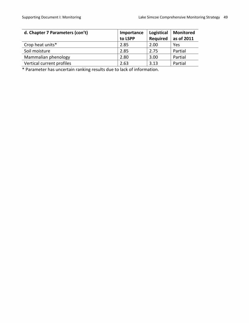
Supporting Document I: Monitoring Lake Simcoe Comprehensive Monitoring Strategy 49
d. Chapter 7 Parameters (con’t) Importance to LSPP
Logistical Required
Monitored as of 2011
Crop heat units* 2.85 2.00 Yes Soil moisture 2.85 2.75 Partial Mammalian phenology 2.80 3.00 Partial Vertical current profiles 2.63 3.13 Partial
* Parameter has uncertain ranking results due to lack of information.

Supporting Document I: Monitoring Lake Simcoe Comprehensive Monitoring Strategy 50
Appendix EList of Program Names and their Agencies for parameters that are currently monitored. The total number of currently monitored parameters for the programs is provided, along with some examples.
Program name(s) Agency(s) No. Example parameter(s) Atmospheric Deposition Monitoring LSRCA/MOE 2 Atmospheric Chlorides and Total Phosphorus Beach Monitoring Regional Health Units/MOE 2 Beach closures, E. coli Benthos Monitoring MNR - ARDS
LSRCA MNR
1 Lake benthos
Hydrometric Program Water Survey of Canada National Hydrometric
LSRCA/MOE EC
1 Flow and water level
Lake Simcoe Fish Feeding Studies Stocked Fish Monitoring
MNR 1 Diet of fish species
Land Use Characterization and Change Monitoring LSCRA 1 Land use LSPP Lake Monitoring LSRCA/MOE 12 Offshore dissolved oxygen, phytoplankton, etc. LSPP Tributary Monitoring & PWQMN LSRCA/MOE 6 Tributary total phosphorus, chlorides, etc Macrophyte Monitoring LSRCA 1 Lake aquatic plants Meteorological Monitoring Flood Forecasting & Warning Network Canadian Climate Data Monitoring
LSRCA/MOE LSRCA EC
6 Air temperature, Precipitation, etc
National Land & Water Information Service Agriculture & Agri-Food Canada 1 Crop heat units Nearshore Community Index Netting Small Fish Biodiversity Netting
MNR MNR
1 Nearshore fish
Nearshore Monitoring LSRCA 7 Nearshore dissolved oxygen, phytoplankton, etc. Offshore Benthic Index Netting & Trawling MNR 1 Offshore fish Ontario Stream Assessment Protocol (OSAP) LSRCA 3 Tributary aquatic plants, stream geomorphology Provincial Groundwater Monitoring Network LSRCA/MOE 2 Groundwater level and quality Sport Fish Contaminant Monitoring MOE/MNR/LSRCA 1 Lake fish contaminants Trent-Severn Waterway Monitoring PARKS CANADA 1 Lake water level Tributary Benthic Invertebrates Monitoring LSRCA 1 Tributary benthos Tributary Fisheries Monitoring LSRCA 2 Tributary fish and water temperature Winter & Open Water Creel Surveys MNR 1 Recreational fishery WPCP Effluent Monitoring Holland Marsh Discharge Monitoring
WPCP & Holland Marsh Discharge Operators
1 WPCP / Polder discharge volume
WTP intake Monitoring WTP operators / MOE 2 WTP nitrogen and phosphorus
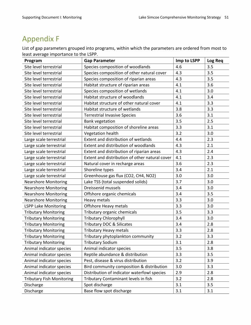
Supporting Document I: Monitoring Lake Simcoe Comprehensive Monitoring Strategy 51
Appendix F List of gap parameters grouped into programs, within which the parameters are ordered from most to least average importance to the LSPP. Program Gap Parameter Imp to LSPP Log Req Site level terrestrial Species composition of woodlands 4.6 3.5 Site level terrestrial Species composition of other natural cover 4.3 3.5 Site level terrestrial Species composition of riparian areas 4.3 3.5 Site level terrestrial Habitat structure of riparian areas 4.1 3.6 Site level terrestrial Species composition of wetlands 4.1 3.0 Site level terrestrial Habitat structure of woodlands 4.1 3.4 Site level terrestrial Habitat structure of other natural cover 4.1 3.3 Site level terrestrial Habitat structure of wetlands 3.8 3.3 Site level terrestrial Terrestrial Invasive Species 3.6 3.1 Site level terrestrial Bank vegetation 3.5 2.5 Site level terrestrial Habitat composition of shoreline areas 3.3 3.1 Site level terrestrial Vegetation health 3.2 3.0 Large scale terrestrial Extent and distribution of wetlands 4.4 2.3 Large scale terrestrial Extent and distribution of woodlands 4.3 2.1 Large scale terrestrial Extent and distribution of riparian areas 4.3 2.4 Large scale terrestrial Extent and distribution of other natural cover 4.1 2.3 Large scale terrestrial Natural cover in recharge areas 3.6 2.3 Large scale terrestrial Shoreline types 3.4 2.1 Large scale terrestrial Greenhouse gas flux (CO2, CH4, NO2) 3.0 3.0 Nearshore Monitoring Lake TSS (total suspended solids) 3.7 3.0 Nearshore Monitoring Dreissenid mussels 3.4 3.0 Nearshore Monitoring Offshore organic chemicals 3.4 3.5 Nearshore Monitoring Heavy metals 3.3 3.0 LSPP Lake Monitoring Offshore Heavy metals 3.3 3.0 Tributary Monitoring Tributary organic chemicals 3.5 3.3 Tributary Monitoring Tributary Chlorophyll 3.4 3.0 Tributary Monitoring Tributary DOC & Silicates 3.4 2.8 Tributary Monitoring Tributary Heavy metals 3.3 2.8 Tributary Monitoring Tributary phytoplankton community 3.2 3.3 Tributary Monitoring Tributary Sodium 3.1 2.8 Animal indicator species Animal indicator species 3.5 3.8 Animal indicator species Reptile abundance & distribution 3.3 3.5 Animal indicator species Pest, disease & virus distribution 3.2 3.9 Animal indicator species Bird community composition & distribution 3.0 3.3 Animal indicator species Distribution of indicator waterfowl species 2.9 2.8 Tributary Fish Monitoring Tributary Contaminant levels in fish 3.2 2.8 Discharge Spot discharge 3.1 3.5 Discharge Base flow spot discharge 3.1 3.1
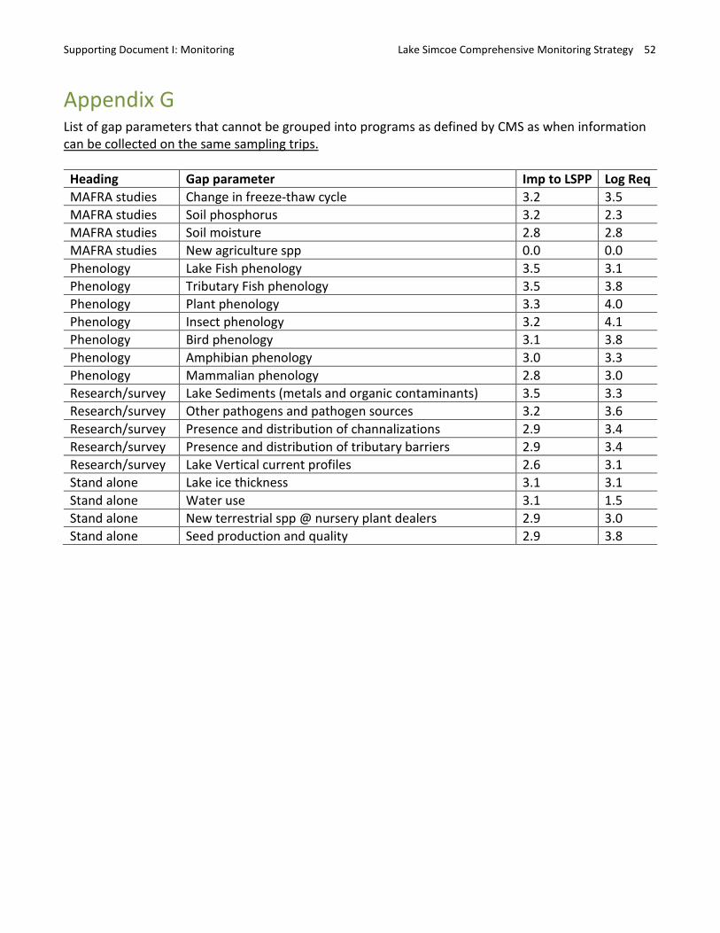
Supporting Document I: Monitoring Lake Simcoe Comprehensive Monitoring Strategy 52
Appendix G List of gap parameters that cannot be grouped into programs as defined by CMS as when information can be collected on the same sampling trips.
Heading Gap parameter Imp to LSPP Log ReqMAFRA studies Change in freeze-thaw cycle 3.2 3.5 MAFRA studies Soil phosphorus 3.2 2.3 MAFRA studies Soil moisture 2.8 2.8 MAFRA studies New agriculture spp 0.0 0.0 Phenology Lake Fish phenology 3.5 3.1 Phenology Tributary Fish phenology 3.5 3.8 Phenology Plant phenology 3.3 4.0 Phenology Insect phenology 3.2 4.1 Phenology Bird phenology 3.1 3.8 Phenology Amphibian phenology 3.0 3.3 Phenology Mammalian phenology 2.8 3.0 Research/survey Lake Sediments (metals and organic contaminants) 3.5 3.3 Research/survey Other pathogens and pathogen sources 3.2 3.6 Research/survey Presence and distribution of channalizations 2.9 3.4 Research/survey Presence and distribution of tributary barriers 2.9 3.4 Research/survey Lake Vertical current profiles 2.6 3.1 Stand alone Lake ice thickness 3.1 3.1 Stand alone Water use 3.1 1.5 Stand alone New terrestrial spp @ nursery plant dealers 2.9 3.0 Stand alone Seed production and quality 2.9 3.8
Supporting Document II: Data Management Lake Simcoe Comprehensive Monitoring Strategy 53
Supporting Document II: Data Management
Lake Simcoe protection is based on adaptive management, which is and will continue to be critically dependent on Lake Simcoe long-term data, and of which data management is an integral component.
Data Management Actions Characterize the current state of Lake Simcoe information management and identify information management gaps.
Propose information management recommendations.
Methods: At the outset, the actions were scoped to cover the management of data rather than all forms of information. An expert working group (Appendix A), consisting of representatives from each Agency including data management experts, identified the key principles for the management of Lake Simcoe data (see below), and the key components (Figure 3 in main document). The current state of Lake Simcoe data management was characterized based on these key principles and components, which allowed the identification of successes and gaps, providing the basis for recommendations.
The working group focussed on the management of long term, ecological and environmental data, such as the parameters identified in the Monitoring section. Reports that are a result of data analysis (bottom line of Figure 3 in main document) were the focus of the Reporting section.
Guiding principles The guiding principles of Lake Simcoe data management, which are similar to principles in MNR IM Strategy (2006), is to protect and conserve data for continuing use, and make it discoverable, readily available and easily accessible to a broad audience of potential users. These involve following good practices for each of the components in data flow model (Figure 3 in main document), as well as a fourth for data accountability:
1. Data Storage: protecting data by regularly updating and frequent backing-up and archiving so that the data remain up-to-date, secure and retrievable,
2. Data Documentation: providing a data management plan that documents data collection and management practices so that the data are useable for a variety of purposes by a variety of users. It is also important to make the data and their documentation discoverable,
3. Data Sharing: making the data accessible to those who might need it, and 4. Data Accountability: having clear oversight and accountability of data management.
Relevant FIPPA Sections: There are two circumstances described in FIPPA in which Lake Simcoe data could be withheld, specifically, sensitive species records (Section 21.1) and data soon to be published in reports or papers (Section 22): http://www.e-laws.gov.on.ca/html/statutes/english/elaws_statutes_90f31_e.htm#BK30)
Supporting Document II: Data Management Lake Simcoe Comprehensive Monitoring Strategy 54
Species at risk 21.1 A head may refuse to disclose a record where the disclosure could reasonably be expected to lead to,
(a) killing, harming, harassing, capturing or taking a living member of a species, contrary to clause 9 (1) (a) of the Endangered Species Act, 2007; (b) possessing, transporting, collecting, buying, selling, leasing, trading or offering to buy, sell, lease or trade a living or dead member of a species, any part of a living or dead member of a species, or anything derived from a living or dead member of a species, contrary to clause 9 (1) (b) of the Endangered Species Act, 2007; or (c) damaging or destroying the habitat of a species, contrary to clause 10 (1) (a) or (b) of the Endangered Species Act, 2007. 2007, c. 6, s. 61. Information soon to be published
22. A head may refuse to disclose a record where, (a) the record or the information contained in the record has been published or is currently available to the public; or (b) the head believes on reasonable grounds that the record or the information contained in the record will be published by an institution within ninety days after the request is made or within such further period of time as may be necessary for printing or translating the material for the purpose of printing it. R.S.O. 1990, c. F.31, s. 22.
• Some of Lake Simcoe data are distributed without having been QA-QCed. In this case, a disclaimer should be included with data that alerts the user that the data are not QA-QCed and requests that any discrepancies reported to the data custodian within the responsible agency. Possible examples can be found at:
http://www.ontario.ca/government/ontario-open-data-terms-use
Appendix A Sub-Working Group Role Name Affiliation Chair Joelle Young EMRB, MOECC Member Rebecca Dolson SIB, MNRF Member Pilar Hernandez ROD, MNRF Member Bruce Pond ARDB, MNRF Member David Lembcke LSRCA Additional Expertise Hamdi Jarjanazi EMRB, MOECC Additional Expertise Ian Bowles EMRB, MOECC Additional Expertise Kali Zapfe EMRB, MOECC Additional Expertise Heath Finley SIB, MNRF Additional Expertise Jean Blondin SIB, MNRF
Supporting Document III: Reporting Lake Simcoe Comprehensive Monitoring Strategy 55
Supporting Document III: Reporting
Reporting is an important step in the adaptive management of Lake Simcoe as it presents the information needed for audiences to measure the state and trend of the ecosystem. This process of publishing the results of monitoring programs is diverse; it is accomplished through a variety of means and at differing scales to support lake and watershed management needs.
Reporting Actions 1. Characterize the current state of reporting on the environmental and ecological health of Lake
Simcoe and identify reporting gaps. Survey reporting since implementation of the LSPP to determine
a. objectives of various reporting formats, b. reporting frequency, c. reporting audience, d. reporting focus and ecosystem components addressed.
Then, identify gaps in the frequency, audience and focus of current reporting. 2. Propose enhanced reporting recommendations.
Methods A CMS reporting working group (Appendix A) composed of partner agency representatives with expertise in environmental and ecological reporting reviewed the LSPP, documenting all policies with explicit and specific reporting requirements that related directly to monitoring. Policies without clear mention of reporting (i.e., implied) or those relating to compliance reporting or reporting on the implementation of the LSPP were not considered as part of this exercise.
The working group then characterized the current state of reporting for the LSPP. Reporting was defined to include written material such as reports and publications as well as presented conference or symposia material. Focus was placed on reporting produced by LSPP partner agencies that dealt with long term ecological or environmental monitoring. The working group surveyed all existing reports and compiled a summary of LSPP reporting since 2009. Reports were categorized according to their focus (lake, watershed), format (e.g. technical report, fact sheet/update, etc.), frequency (year) and their intended audience (agency staff, technical scientific or public).
Successes and gaps in LSPP reporting were identified by comparing the LSPP requirements to the current state of reporting. A small number of recommendations were developed to help maintain and enhance future LSPP reporting.
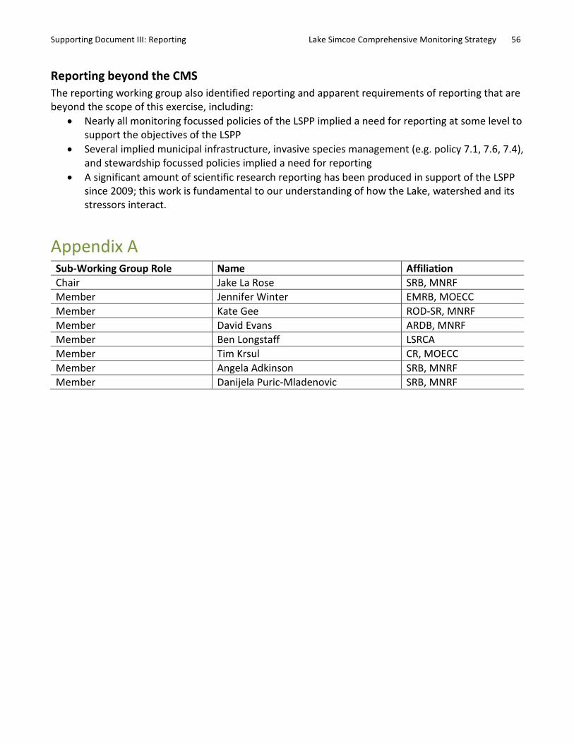
Supporting Document III: Reporting Lake Simcoe Comprehensive Monitoring Strategy 56
Reporting beyond the CMS The reporting working group also identified reporting and apparent requirements of reporting that are beyond the scope of this exercise, including:
• Nearly all monitoring focussed policies of the LSPP implied a need for reporting at some level to support the objectives of the LSPP
• Several implied municipal infrastructure, invasive species management (e.g. policy 7.1, 7.6, 7.4), and stewardship focussed policies implied a need for reporting
• A significant amount of scientific research reporting has been produced in support of the LSPP since 2009; this work is fundamental to our understanding of how the Lake, watershed and its stressors interact.
Appendix A Sub-Working Group Role Name Affiliation Chair Jake La Rose SRB, MNRF Member Jennifer Winter EMRB, MOECC Member Kate Gee ROD-SR, MNRF Member David Evans ARDB, MNRF Member Ben Longstaff LSRCA Member Tim Krsul CR, MOECC Member Angela Adkinson SRB, MNRF Member Danijela Puric-Mladenovic SRB, MNRF

Recommended