Embed Size (px)
Citation preview
J O U R N A L O F H U N G A R I A N G E O M A T H E M A T I C S
Volume 1
14
A NEW METHOD OF RESOURCE ESTIMATION FOR BAUXITE AND OTHER SOLID MINERAL
DEPOSITS
Gy. Bárdossy a, I. R.Szabó b
G. Varga c
a [email protected] Hungarian Academy of Sciences, Budapest, Hungary
b Bakony Bauxite Mining Co. Tapolca, Hungary.
c Bakony Bauxite Mining Co. Tapolca, Hungary.
Abstract
First the basic concepts of resource estimation are discussed. All existing traditional methods of resource and reserve estimation are based either on deterministic or on stochastic approaches and they apply real (crisp) numbers as input data. The main disadvantage of the traditional estimation methods is that the uncertainty of the estimates cannot be determined quantitatively, instead so called „resource categories” are distinguished, e.g. measured, indicated, inferred resources. The authors of this paper investigated new, uncertainty oriented mathematical methods, e.g. interval analysis, fuzzy set theory, probability-bounds analysis and hybrid arithmetic to calculate quantitatively the errors of the resource estimations. As a first step, they analyzed the sources of uncertainties of resource estimations, followed by a short presentation of the above listed mathematical methods. The evaluation of the errors starts at the level of the input data and the propagation of errors is followed up to the end results. The authors performed a number of test calculations on karst bauxite deposits of Hungary, applying the fuzzy set theory. The step-be-step methodology is described and is demonstrated on figures. This methodology is relative simple and does not require high-level mathematical skill. It is suitable for the resource estimation of any other type of solid mineral deposits. The mineable and the economic reserves can be also calculated by the method recommended above. Finally the estimation results can serve as a base for risk calculations of mining investments as well.
Keywords: resource estimation, uncertainties, errors, fuzzy set theory
J O U R N A L O F H U N G A R I A N G E O M A T H E M A T I C S
Volume 1
15
1. INTRODUCTION The estimation of resources and reserves of solid mineral deposits – fossil fuels, ores and non-metallic mineral commodities – is a subject of paramount importance for mineral exploration, mining, for investors and shareholders. Hundreds of articles and several books have been published on the subject during the last five decades. General recommendations have been elaborated for the classification of resources and reserves by a commission of the United Nations (1997), including the definitions of mineral resources and reserves. Nevertheless, several open questions remained unsolved, particularly concerning the uncertainties of the estimates and the risks related to them. The problem is particularly valid to the bauxite deposits, as mining experiences often showed significant deviations from the originally calculated resources. During the last decades new „uncertainty oriented” mathematical methods have been elaborated and successfully applied in medicine, health, biology, ecology, communication systems, economy etc. Bárdossy and J.Fodor (2000, 2001a and 2001b) discussed the general aspects of their application to geological investigations, and they carried out a number of test calculations. Bárdossy and B.Fodor (2001) discussed the possibility of applying these methods to resource and reserve estimations, in general. Bárdossy, R.Szabó and Varga (2001) carried out a number of resource estimations by these methods on different types of karst-bauxite deposits in Hungary. In the following first the basic concepts of resource estimation, the advantages and the limitations of the traditional methods are discussed. This is followed by a short presentation of the new mathematical methods, illustrated by test calculations, carried out on selected Hungarian bauxite deposits. The estimation of reserves requiring the calculation of economic parameters, such as the internal rate of return (IRR) and the net present value (NPV) is beyond the scope of this article.
2. BASIC CONCEPTS OF RESOURCE ESTIMATION Resource estimation involves the calculation of tonnage and grade of the ore (averages and spatial distribution). Different cut-off values are used in the different bauxite regions of the world, based on geological, mining, extraction and economic aspects of the given region. We do not discuss these aspects in this article, as they are well known and main-ly site specific.The ore resource estimation is based on input data obtained by the mineral exploration: mapping, trenching, pitting, drilling and geophysical measurements. Samples are taken from the deposits. The complicated problems of bauxite ore sampling have been discussed in detail by Bárdossy and Aleva (1990 pp.520-529). For all types of resource estimation - traditional and new ones – the right geological knowledge of the deposit is a basic precondition. This knowledge is expressed in the form of a deposit model. This important requirement has been neglected in the past in several cases, leading to a complete misestimation of the given resources. In the case when the deposit model cannot be established unequivocally – that is two or more variants are possible – it is recommended to perform several resource estimations, one for each possible model. The results can be compared and subjective probabilities can be attached to them. These probabilities express the experiences of the exploration geologist and his rational opinion about the chances of each variant.
J O U R N A L O F H U N G A R I A N G E O M A T H E M A T I C S
Volume 1
16
Even in the case of only one valid deposit model, the results of the resource estimation will not correspond exactly to the natural reality. The larger are the deviations from the real values, the lower is the overall reliability of the resource estimation. From the beginning, one of the main goals of exploration geologists was the determination and quantification of these uncertainties, designated also by the rather vague term geological assurance. This is the point where our new methods essentially differ from the traditional ones and offer better solution. Let us review at first the types of uncertainties and errors related to resource estimations. (For us the term uncertainty expresses the imperfection and incompleteness of our knowledge. On the other hand, error is the difference between a true value and an estimate of that value. In the following these two terms will be used in this sense). Two main types can be distinguished:
• Natural variability, an inherent feature of all geological objects and processes, is valid for the mineral deposits as well. The higher the variability of the variables included into the resource estimation, such as geometry of the deposit and grade distribution, the more uncertainties are connected with the results of the calculations. But there is a further influencing factor: in all deposits „structured” and „unstructured” features can be distinguished. The structured features, called also trends, can be described mathematically by trend-surface-analysis, thus they do not increase significantly the error of the resource estimation. On the other hand, local unstructured features may occur unexpectedly and their spatial position and magnitude cannot be exactly predicted. The proportion of structured and unstructured features is quite different in the mineral deposits of the world, according to our personal experiences.
• Uncertainties related to the mineral exploration are due to incomplete geological experience, lack of time and money and to human errors and incompetency. Their main types are as follows:
o Lack of representative sampling may be the result of technical, temporal and financial restrictions. It is a significant source of uncertainty of the resource estimations.
o Errors of laboratory measurements („analytical errors”) comprise all chemical, mineralogical, technological and other laboratory measurements related to the resource estimation process. They consist of random and systematical components. Being studied and investigated by many authors, we do not discuss them in detail (Day, Underwood 1991).
o Conceptual and model uncertainties. When evaluating a mineral deposit, existing geological concepts are applied necessarily. Unfortunately, they are not always adequate to the given deposit. Natural analogues, broadly applied in mineral exploration, are often imperfect, as they cannot take into account unknown, undetected local features. Even in the case of a valid deposit model, simplifications may increase the general error of the resource estimation.
o Errors due to incorrect use of mathematical methods. They are rather frequent, as it is often neglected that resource estimation is a mathematical (statistical) procedure. And when doing so, the mathematical rules should be strictly respected. Some examples: Interpolation between neighboring boreholes beyond the range of
influence of the given variable may lead to erroneous results. The generally calculated arithmetic means are valid only to normal or
quasy-normal distributions. However, in mineral deposits the distribution of ore thickness and of some chemical components is often highly
J O U R N A L O F H U N G A R I A N G E O M A T H E M A T I C S
Volume 1
17
skewed. In such cases „robust” estimators can be applied instead of the arithmetic mean. Due to this error up to 30 % we found overestimations of the bauxite resources in several former exploration reports on bauxite deposits of Hungary.
So called „point-estimates” are reported in most cases for the deposit, instead of the mathematically required „interval-estimate” including confidence limits and levels of significance. Theoretically, the 90 and 95 % levels of significance are most suitable for the resource estimations.
o Errors related to the choice of mathematical models. The choice between existing mathematical models is often difficult and can be a source of additional errors. E.g. the mathematical modeling of the „experimental variograms” influences the length of the corresponding ranges of influence. The different robust estimators, mentioned above also result in different values for the measure of central tendency.
Natural variability being an inherent feature of Nature, can be studied, mathematically described, but not diminished. On the other hand, all the uncertainties and errors of mineral exploration are human factors and it depends on us how much we wish and try to diminish them.
3. ADVANTAGES AND LIMITATIONS OF THE TRADITIONAL METHODS Two main groups of traditional resource estimations can be distinguished:
1. The scalar-geometric methods 2. The spatial („geostatistical”) methods
The well known scalar-geometric methods comprise the block methods (triangular, regular, squares, rectangular, polygonal and irregular or geological blocks), the methods of profiles (vertical, horizontal, inclined) and the isopach method. All these methods being well known, we do not discuss them. The principles of the spatial methods were elaborated by Matheron (1963) in his „theory of regionalized variables”, called also geostatistics. This theory takes into account the spatial autocorrelation of the geological variables. By the method of variography the ranges of influence of the variables can be determined in two or three dimensions and predictions can be done for the spatial continuity of the deposit. An optimized estimation procedure was elaborated for the prediction of spatial points („point kriging”) and for blocks („block kriging”) by the solution of a set of linear equations. This new theory represented an important step ahead for resource estimations. It has been applied to bauxite deposits first in France (Maréchal and Roullier 1970), followed by Hungary (Bárdossy et al. 1985). Later the methodology has been mathematically developed and is broadly applied in all branches of mineral exploration. More than hundred articles appeared on the subject. Here we refer only to the books of Journel and Huijbregts (1978), Cressie (1991) and Goovaerts (1997). The different kriging methods use the kriging variance to express the uncertainty of kriging results. An improvement has been suggested by Yamamoto (1999) when applying interpo-lation variance, a parameter depending both on data values and data geometry. Let us stress that eveb this parameter expresses only the natural variability of the given variable and not the entire uncertainty as outlined in the first part of this article.
J O U R N A L O F H U N G A R I A N G E O M A T H E M A T I C S
Volume 1
18
Further limitations of geostatistics were pointed out by Diehl (1997): thus with decreasing number of boreholes (below about 20), the calculation of variograms becomes increasingly uncertain, even impossible. This is a serious limitation for the application of the method in the case of relatively small deposits. Further uncertainties are related to the choice of the appropriate variogram model, as mentioned above. Furthermore, with high proportion of the nugget-effect the variogram model becomes uncertain. The generally applied rectangular kriging blocks depict rather roughly the real contours of the deposits. According to our own experiences, by applying different lags (distance intervals) the form and parameters of the experimental variogram may change significantly. Several important spatial features, such as the position of tectonic lines, dissecting the deposits, or the contouring of the deposit cannot be satisfactorily resolved by geostatistical methods. Finally, the application of geostatistics requires considerable expertise and a solid mathematical background, as pointed out by Diehl (1997). The results of all the traditional methods can be presented in two ways:
• Deterministic presentation. In this case only the weighted averages of the resource estimation are reported, based on the well-known „best estimate” or „best guess” con-cept. From the mathematical point of view these are point-estimates, giving no information on the amount of errors of the resource estimation.
• Probabilistic (stochastic) presentation, when standard deviations and types of distribution are also reported. But the most important difference is, that instead of simple point-estimates interval-estimates are calculated involving confidence intervals at levels of confidence, chosen by the experts of the resource estimation. Uncertainties are generally expressed by the well-known resource categories, such as inferred, indicated and measured. However this classification is not based on uncertainty-calculations, but on the judgment of one or several experts (Diehl 1997).
Theoretically the geostatistical methods are interval estimates, as the „kriging standard deviations” refer to given levels of confidence. It should be stressed however that these standard deviations express only the amount of natural variability of the given variable and not the uncertainties related to the exploration process, as outlined above. All traditional methods are based on the probability theory and consequently on its fundamental axioms, elaborated by Kolmogorov (1933). The third axiom, declaring the principle of additivity recognizes only mutually exclusive cases. As a consequence, all pro-babilistic methods have to work with well-defined, sharp boundaries and mutually exclusive geological objects. No transitions are admitted! However in geology, and particularly in bauxite deposits, sharp boundaries are rare, gradual transitions with mixed features are much more frequent, let us mention only the bauxite- clayey bauxite- bauxitic clay- clay sequence. Thus this axiom represents a serious limitation for the traditional resource estimations. Mathematical statistics, the practical realization of the probability theory, basically requires repeated experiments (The drilling of a bore-hole is an experiment in statistical sense). However it is practically impossible to fulfill this requirement in mineral exploration. Imagine repeating 100 times a drilling grid by small shifting and rotating of the drilling locations. This would be simply nonsensical! For this reason the error of the deposit area cannot be calculated, only approximative guesses can be produced. The estimation error is also strongly influenced by the choice of the size of the estimation blocks. The larger the block, the smaller is the estimation error. Thus the categorization of the resources can be easily manipulated by changing the size of the estimation blocks.
J O U R N A L O F H U N G A R I A N G E O M A T H E M A T I C S
Volume 1
19
Finally, several geological features cannot be determined exactly; they can be described only in a semi-quantitative or even qualitative way. The traditional methods of resource estimation are not suitable for the mathematical evaluation of such data; consequent-lye they have to be excluded from the estimation procedure. Much useful information is lost this way.
4. THE NEW, UNCERTAINTY ORIENTED MATHEMATICAL METHODS FOR RESOURCE ESTIMATION All the above-discussed traditional methods apply real numbers (called also crisp numbers) as input data. However, real numbers do not express the uncertainties related to them. Together with the limitations discussed above, this is the main reason why traditional resource estimations cannot determine the total error of the estimation results. Instead resource categories were created to express at least approximately the amount of uncertainty of a given resource estimate, e.g. measured, indicated, inferred (Mc Kelvey 1986). Shortcomings of this concept have been discussed by many authors, e.g. Akin (1997), Diehl (1997), Wellmer (1985,1989). During the last decades new mathematical methods have been developed, suitable to handle uncertainties from the beginning, that is from the level of the input data. Their common feature is that they apply different new types of numbers expressing the uncertainties related to them. The main methods are as follows:
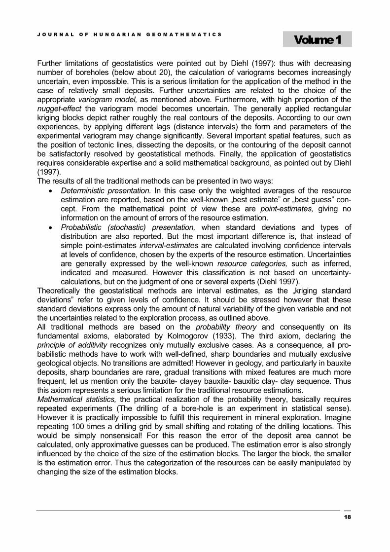
• Interval analysis (Moore 1979) replaces the crisp numbers by uncertainty intervals. It is assumed that the true value is somewhere within the interval (Figure 1). Interval analysis lacks gradations and is the simplest method to express uncertainty through arithmetic calculations.
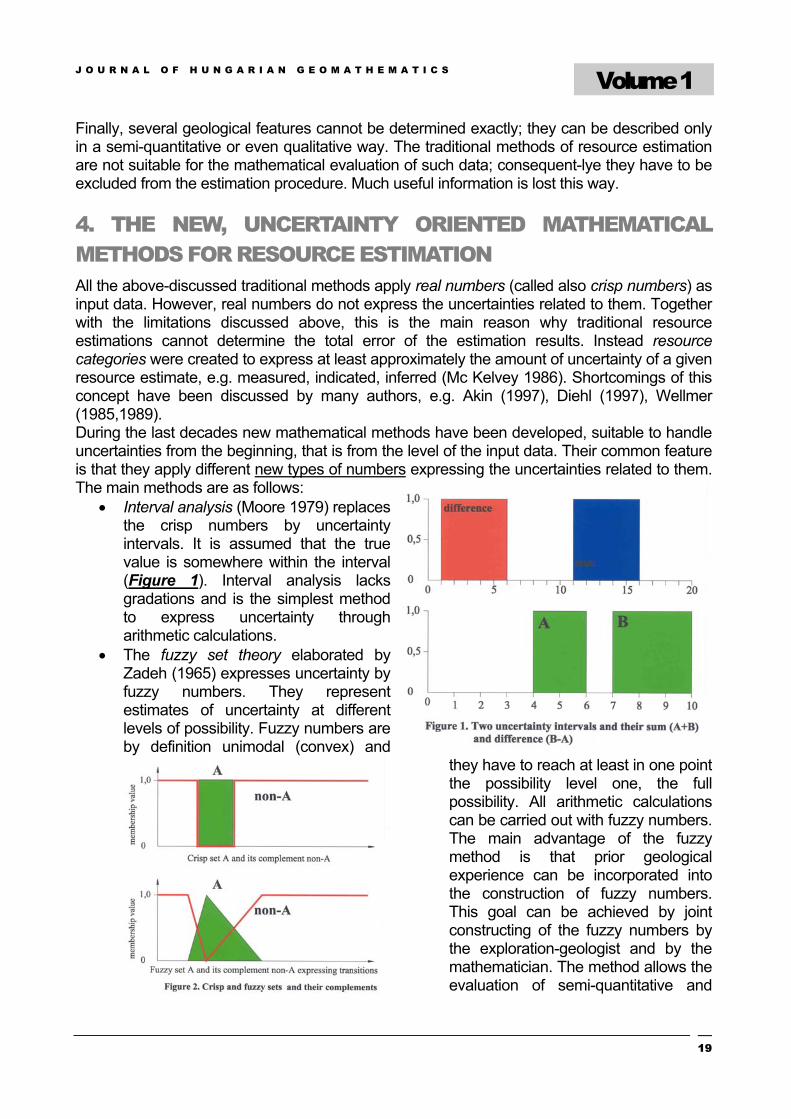
• The fuzzy set theory elaborated by Zadeh (1965) expresses uncertainty by fuzzy numbers. They represent estimates of uncertainty at different levels of possibility. Fuzzy numbers are by definition unimodal (convex) and
they have to reach at least in one point the possibility level one, the full possibility. All arithmetic calculations can be carried out with fuzzy numbers. The main advantage of the fuzzy method is that prior geological experience can be incorporated into the construction of fuzzy numbers. This goal can be achieved by joint constructing of the fuzzy numbers by the exploration-geologist and by the mathematician. The method allows the evaluation of semi-quantitative and
J O U R N A L O F H U N G A R I A N G E O M A T H E M A T I C S
Volume 1
20
qualitative input data as well. The transitions, mentioned above, can be also expressed by fuzzy numbers (Figure 2). According to our test calculations, the fuzzy numbers are highly suitable to carry out resource estimations. The development of fuzzy geostatistic (Bárdossy A. et al. 1990) was an essential step ahead for the evaluation of spatial uncertainty, especially for resource estimations.
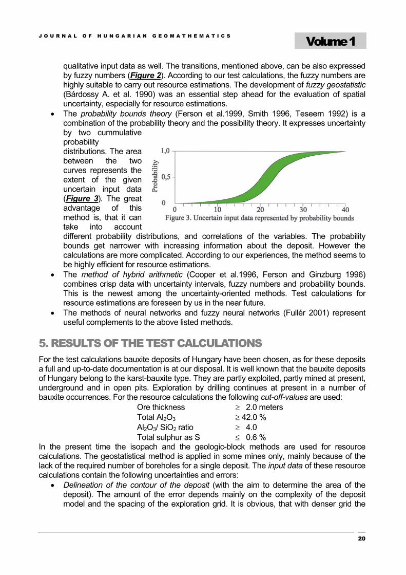
• The probability bounds theory (Ferson et al.1999, Smith 1996, Teseem 1992) is a combination of the probability theory and the possibility theory. It expresses uncertainty by two cummulative probability distributions. The area between the two curves represents the extent of the given uncertain input data (Figure 3). The great advantage of this method is, that it can take into account different probability distributions, and correlations of the variables. The probability bounds get narrower with increasing information about the deposit. However the calculations are more complicated. According to our experiences, the method seems to be highly efficient for resource estimations.
• The method of hybrid arithmetic (Cooper et al.1996, Ferson and Ginzburg 1996) combines crisp data with uncertainty intervals, fuzzy numbers and probability bounds. This is the newest among the uncertainty-oriented methods. Test calculations for resource estimations are foreseen by us in the near future.
• The methods of neural networks and fuzzy neural networks (Fullér 2001) represent useful complements to the above listed methods.
5. RESULTS OF THE TEST CALCULATIONS For the test calculations bauxite deposits of Hungary have been chosen, as for these deposits a full and up-to-date documentation is at our disposal. It is well known that the bauxite deposits of Hungary belong to the karst-bauxite type. They are partly exploited, partly mined at present, underground and in open pits. Exploration by drilling continues at present in a number of bauxite occurrences. For the resource calculations the following cut-off-values are used:
Ore thickness ≥ 2.0 meters Total Al2O3 ≥ 42.0 % Al2O3/ SiO2 ratio ≥ 4.0 Total sulphur as S ≤ 0.6 %
In the present time the isopach and the geologic-block methods are used for resource calculations. The geostatistical method is applied in some mines only, mainly because of the lack of the required number of boreholes for a single deposit. The input data of these resource calculations contain the following uncertainties and errors:
• Delineation of the contour of the deposit (with the aim to determine the area of the deposit). The amount of the error depends mainly on the complexity of the deposit model and the spacing of the exploration grid. It is obvious, that with denser grid the
J O U R N A L O F H U N G A R I A N G E O M A T H E M A T I C S
Volume 1
21
error of delineation diminishes. The calculation of the delineated area is carried out by an appropriate computer program. Its error is negligible. As repeated experiments, that is repeated drilling grids cannot be executed, the error of the deposit area cannot be exactly calculated. This is the main shortcoming of the traditional resource estimations.
• The thickness of the ore-grade bauxite. It is determined in the boreholes with ± 10 cm error, if the core recovery is more than 90 %. With smaller recovery the error may increase to 20-40 % for the given core interval. (In Hungarian bauxite exploration this occurs rarely). Geophysical logging can diminish this error.
• The bulk-density is determined by laboratory measurements of ore cores. More than 100 measurements are carried out for each deposit. The average analytical error is ±5-10 rel. %. These small-scale measurements are completed by large scale (½ - 1 m3) ore samples taken from neighboring bauxite mines, assuming that they have a higher representativity.
• The average analytical errors of the chemical analyses are as follows: Al2O3 ±0,5 %, SiO2 ±0,3 %, CaO,MgO and total sulphur in S ±0,2 % (absolute percentages within the range of commercial bauxite composition).
Before starting the resource calculations variograms have been calculated by us for the bauxite-ore thickness, and for the above-mentioned chemical components, by using the well-known „VARIOWIN” computer program. All the selected bauxite deposits were checked for the drilling grid spacing: it should not surpass the calculated ranges of influence. This requirement was met in all cases. From the new, uncertainty oriented methods we present here the results obtained by the fuzzy methodology. As a first step the fuzzy numbers of the input data have been determined. It should be stressed, that according to our experiences, the construction of the fuzzy numbers has particularities for each input variable, as it will be shown later. An other essential difference to the traditional methods is the ranking of the boreholes. In all traditional methods only productive and improductive boreholes are distinguished. The latter ones comprise boreholes not reaching all the cut-off-values. However, according to our experience, these boreholes may also contain important information for the resource estimation, e.g. boreholes not reaching the required cut-off-thickness, but their bauxite being of high-grade composition. In other boreholes only one grade component did not reach the required value, and the thickness is also acceptable. Other boreholes contained information for the delineation of the deposit etc. We consider these cases as transitional and included them by the fuzzy numbers into the resource estimation. This way it was possible to increase considerably the accuracy of the final estimation results. Examples will be shown later. The construction of the fuzzy numbers may occur in three different ways:
• For the chemical components and the bulk density the analytical error, established by the chemical laboratories is used, completed by the standard error of the mean and the confidence interval at 95% level of confidence.
• For semi-quantitative and qualitative variables, like the area of the deposit, the deposit model and the exploration-expert’s opinion was taken into account, completed by the above mentioned direct borehole information.
• Additional estimating points have been calculated, mainly in the marginal sector to incorporate the information of the above-mentioned transitional boreholes. Here again the deposit model and the expert’s opinion were taken into account
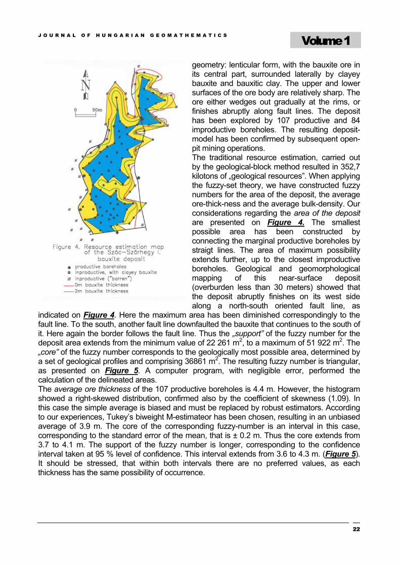
In the following the resource estimation of selected bauxite deposits will be presented: The Szőc-Szárhegy deposit is situated in the SW part of the Bakony Mts. It has a relatively simple
J O U R N A L O F H U N G A R I A N G E O M A T H E M A T I C S
Volume 1
22
geometry: lenticular form, with the bauxite ore in its central part, surrounded laterally by clayey bauxite and bauxitic clay. The upper and lower surfaces of the ore body are relatively sharp. The ore either wedges out gradually at the rims, or finishes abruptly along fault lines. The deposit has been explored by 107 productive and 84 improductive boreholes. The resulting deposit-model has been confirmed by subsequent open-pit mining operations. The traditional resource estimation, carried out by the geological-block method resulted in 352,7 kilotons of „geological resources”. When applying the fuzzy-set theory, we have constructed fuzzy numbers for the area of the deposit, the average ore-thick-ness and the average bulk-density. Our considerations regarding the area of the deposit are presented on Figure 4. The smallest possible area has been constructed by connecting the marginal productive boreholes by straigt lines. The area of maximum possibility extends further, up to the closest improductive boreholes. Geological and geomorphological mapping of this near-surface deposit (overburden less than 30 meters) showed that the deposit abruptly finishes on its west side along a north-south oriented fault line, as
indicated on Figure 4. Here the maximum area has been diminished correspondingly to the fault line. To the south, another fault line downfaulted the bauxite that continues to the south of it. Here again the border follows the fault line. Thus the „support” of the fuzzy number for the deposit area extends from the minimum value of 22 261 m2, to a maximum of 51 922 m2. The „core” of the fuzzy number corresponds to the geologically most possible area, determined by a set of geological profiles and comprising 36861 m2. The resulting fuzzy number is triangular, as presented on Figure 5. A computer program, with negligible error, performed the calculation of the delineated areas. The average ore thickness of the 107 productive boreholes is 4.4 m. However, the histogram showed a right-skewed distribution, confirmed also by the coefficient of skewness (1.09). In this case the simple average is biased and must be replaced by robust estimators. According to our experiences, Tukey’s biweight M-estimateor has been chosen, resulting in an unbiased average of 3.9 m. The core of the corresponding fuzzy-number is an interval in this case, corresponding to the standard error of the mean, that is ± 0.2 m. Thus the core extends from 3.7 to 4.1 m. The support of the fuzzy number is longer, corresponding to the confidence interval taken at 95 % level of confidence. This interval extends from 3.6 to 4.3 m. (Figure 5). It should be stressed, that within both intervals there are no preferred values, as each thickness has the same possibility of occurrence.
J O U R N A L O F H U N G A R I A N G E O M A T H E M A T I C S
Volume 1
23
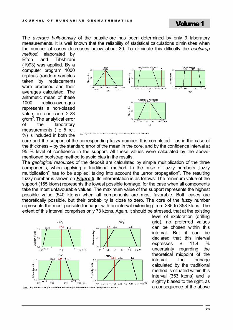
The average bulk-density of the bauxite-ore has been determined by only 9 laboratory measurements. It is well known that the reliability of statistical calculations diminishes when the number of cases decreases below about 30. To eliminate this difficulty the bootstrap method, elaborated by Efron and Tibshirani (1993) was applied. By a computer program 1000 replicas (random samples taken by replacement) were produced and their averages calculated. The arithmetic mean of these 1000 replica-averages represents a non-biased value, in our case 2.23 g/cm3. The analytical error of the laboratory measurements ( ± 5 rel. %) is included in both the core and the support of the corresponding fuzzy number. It is completed – as in the case of the thickness – by the standard error of the mean in the core, and by the confidence interval at 95 % level of confidence in the support. All these values were calculated by the above-mentioned bootstrap method to avoid bias in the results. The geological resources of the deposit are calculated by simple multiplication of the three components, when applying a traditional method. In the case of fuzzy numbers „fuzzy multiplication” has to be applied, taking into account the „error propagation”. The resulting fuzzy number is shown on Figure 5. Its interpretation is as follows: The minimum value of the support (165 ktons) represents the lowest possible tonnage, for the case when all components take the most unfavourable values. The maximum value of the support represents the highest possible value (540 ktons) when all components are most favorable. Both cases are theoretically possible, but their probability is close to zero. The core of the fuzzy number represents the most possible tonnage, with an interval extending from 285 to 358 ktons. The extent of this interval comprises only 73 ktons. Again, it should be stressed, that at the existing
level of exploration (drilling grid), no preferred values can be chosen within this interval. But it can be declared that this interval expresses ± 11.4 % uncertainty regarding the theoretical midpoint of the interval. The tonnage calculated by the traditional method is situated within this interval (353 ktons) and is slightly biased to the right, as a consequence of the above
J O U R N A L O F H U N G A R I A N G E O M A T H E M A T I C S
Volume 1
24
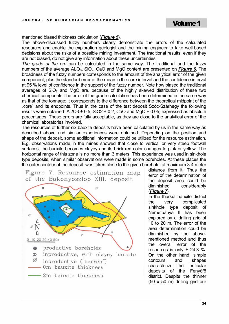
mentioned biased thickness calculation (Figure 5). The above-discussed fuzzy numbers clearly demonstrate the errors of the calculated resources and enable the exploration geologist and the mining engineer to take well-based decisions about the risks of a possible mining investment. The traditional results, even if they are not biased, do not give any information about these uncertainties. The grade of the ore can be calculated in the same way. The traditional and the fuzzy numbers of the average Al2O3, SiO2, CaO and MgO content are presented on Figure 6. The broadness of the fuzzy numbers corresponds to the amount of the analytical error of the given component, plus the standard error of the mean in the core interval and the confidence interval at 95 % level of confidence in the support of the fuzzy number. Note how biased the traditional averages of SiO2 and MgO are, because of the highly skewed distribution of these two chemical componets.The error of the grade calculation has been determined in the same way as that of the tonnage: it corresponds to the difference between the theoretical midpoint of the „core” and its endpoints. Thus in the case of the test deposit Szőc-Szárhegy the following results were obtained: Al2O3 ± 0.5, SiO2 ± 0.2, CaO and MgO ± 0.05, expressed as absolute percentages. These errors are fully acceptable, as they are close to the analytical error of the chemical laboratories involved. The resources of further six bauxite deposits have been calculated by us in the same way as described above and similar experiences were obtained. Depending on the position and shape of the deposit, some additional information could be utilized for the resource estimation. E.g. observations made in the mines showed that close to vertical or very steep footwall surfaces, the bauxite becomes clayey and its brick red color changes to pink or yellow. The horizontal range of this zone is no more than 3 meters. This experience was used in sinkhole type deposits, when similar observations were made in some boreholes. At these places the the outer contour of the deposit was taken close to the given borehole, at maximum 3-4 meter
distance from it. Thus the error of the determination of the deposit area could be diminished considerably (Figure 7). In the Iharkút bauxite district the very complicated sinkhole type deposit of Németbánya II has been explored by a drilling grid of 10 to 20 m. The error of the area determination could be diminished by the above-mentioned method and thus the overall error of the resources is only ± 24.3 %. On the other hand, simple contours and shapes characterize the lenticular deposits of the Fenyőfő district. Despite the thinner (50 x 50 m) drilling grid our
J O U R N A L O F H U N G A R I A N G E O M A T H E M A T I C S
Volume 1
25
calculations resulted in only ± 20.7 % error of the resource calculation, for the deposit No.XIII. A negative example is the Halimba II/SE deposit, characterized by particularly irregoular contours. As a consequence, a very broad area was obtained between the outer and the inner contour line. The triangular shape of the former calculations had to be changed to a trapezoidal, better expressing the increased uncertainty. Thus an overall ± 31.4 % error was obtained by the calculations, despite the close drilling grid (25 x 25 m). Further resource estimations using the outlined methodology are on the way.
6. CONCLUSIONS • Our test calculations proved that the new method of resource calculation is relatively
simple and can be carried out quickly. • A great advantage of the method is that fuzzy numbers are robust: subjective changes
do not influence significantly the results. • By the use of fuzzy numbers the entire error of resource estimation could be
determined quantitatively, this being the most important achievement of the new method.
• When using the new method, the investor can decide whether the estimation error is acceptable to him (including to the financial risk connected to it), or not. In the latter case additional exploration can be started. By the use of the suggested new method the location of the additional boreholes can be optimized and the exploration can be stopped when the required error-level is reached.
• The method outlined in this paper is suitable for any solid mineral deposits. At present further test calculations are on the way on selected lignite and building material deposits in Hungary.
• Minerable resources and commercial reserves can be calculated also by the above outlined methods.
7. REFERENCES 1. Akin,H. 1997: Zur Akzeptanz der Geostatistik als Grundlage der Vorratsklassifikation. –
Schriftenreihe der GDMB.”Klassifikation von Lagerstätten” H.79.pp.9-19. 2. Bárdossy,A.,Bogárdi,I.,Kelly,W.E. 1990: Kriging with imprecise (fuzzy) variograms.
I.Theory. Mathematical Geology. 22.pp.63-79. 3. Bárdossy,Gy. and Aleva,G.J.J. 1990: Lateritic bauxites. – Elsevier. Amsterdam-Oxford-
New York-Tokyo. „Developments in Economic Geology series No.27. 624p 4. Bárdossy,Gy., Bárdossy,A., Fodor,B., Lengyel,K. 1985: Die Anwendung
geostatistischer Methoden in der ungarischen Bauxitprospektion und ihr Einfluß auf den Bauxitabbau. –Erzmetall. 38. Nr.1.pp.18-22.
5. Bárdossy,Gy.and Fodor,J. 2000: Handling uncertainty in geology by new mathematical methods. – In: Proceedings Int.Symp.Hung.Researchers. „Computational Intelligence”. Budapest 2000.Nov.2. pp.93-109.
6. Bárdossy,Gy.and Fodor,J. 2001: Experiences in the application of fuzzy sets to geology. – In:Proceedings Int.Symp.Hung.Researchers. „Computational Intelligence”. Budapest. 2001.Nov.12. pp.89-102.
J O U R N A L O F H U N G A R I A N G E O M A T H E M A T I C S
Volume 1
26
7. Bárdossy,Gy. and Fodor,J.2001: Traditional and new ways to handle uncertainty in geology. – Natural Resources Research. Vol.10.No.3.pp.179-187.
8. Bárdossy,Gy.and Fodor B. 2001: New methods for the determination of uncertainties in resource estimations. (in Hungarian). – Földtani Kutatás. Budapest.No.4.pp.
9. Bárdossy,Gy., R.Szabó I. and Varga G. 2001: New possibilities for the evaluation of reserves as illustrated on bauxite deposits of Hungary. (in Hungarian). – Földtani Kutatás. Budapest. Vol.38.No.3.pp.35-44.
10. Cooper,J.A.,Ferson,S.,Ginzburg,L.R. 1996: Hybrid processing of stochastic and subjective uncertainty data. – Risk Analysis. 16.pp.785-791.
11. Cressie,N. 1991: Statistics for Spatial Data. – John Wiley and Sons.New York. 900p. 12. Day,R.A. and Underwood,P.L.1991: Quantitative analysis. – Prentice Hall,Englewood
Cliff, Nwe Jersey.Sixth Edition. 13. Diehl,P. 1997: Quantification of the term „geological assurrance” in coal classification
using geostatistical methods. – Schriftenreihe der GDMB „Klassifikation von Lagerstätten H.79.pp.187-203.
14. Efron,B. and Tibshirani,R.J. 1993: An introduction to the bootstrap. - Chapman &Hall New York, London.177p
15. Ferson,S. and Ginzburg, L.R. 1996: Different methods are needed to propagate ignorance and variability. – Reliability, Engineering and System Safety. 54.pp.133-144
16. Ferson,S.,Root,W.,Kuhn,R. 1999: RAMAS Risk Calc.Risk assessment with uncertain numbers. – Applied Biomathematics.Setauket, New York 184p
17. Goovaerts, P. 1997: Geostatistics for Natural Resources Estimation. – Oxford University Press. New York. 483
18. Journel,A.G. and Huijbregts,Ch.J. 1978: Mining Geostatistics. – Academic Press.New York. 600p
19. Maréchal, A.,Roullier,J.P.1970: Étude géostatistique des gisements de bauxite francais. – Rev.Industrie Minérale. 52. pp.492-507
20. Matheron,G. 1963: Principles of geostatistics. – Economic Geology.58. pp.1246-1266. 21. Moore,R.E. 1979: Methods and applications of interval analysis. – SIAM Studies on
Applied Mathematics. Vol.2. Philadelphia., 22. Smith,J.E. 1996: Generalized Chebychev inequalities: theory and applications in
decision analysis. – Operations Research. 42. pp.807-825. 23. Tesseem,B. 1992: Interval probability propagation. – International Journal of
Approximate Reasoning. 7. pp.95-120 24. Wellmer, F.W.1985: Rechnen für Lagerstättenkundler und Rohstoffwirtschaftler. Teil.I.
–Clausthaler Tektonische Hefte.22. pp 1-187. 25. Wellmer,F.W. 1989: Rechnen für Lagerstättenkundler und Rohstoffwirtschaftler. Teil.II.
– Clausthaler Tektonische Hefte. 26.pp 1-462 26. Yamamoto,K. 1999: Quantification of uncertainty in ore reserve estimation: Applications
to Chapada Copper Deposit, State of Goiás, Brazil. – Natural Resources Research. Vol.8. No.1.pp153-163
27. Zadeh,L. 1965: Fuzzy sets. – Information and C8.pp.338-353.


![HANON - Method - [Piano] - Hanon Book (1)](https://img.pdfslide.fr/doc/110x75/577cd7e51a28ab9e789feeb5/hanon-method-piano-hanon-book-1.jpg)