Embed Size (px)
Citation preview
>91
L A N D T E N U R E J O U R N A L R E v U E D E s q U E s T i O N s f O N c i è R E s R E v i s TA s O b R E T E N E N c i A D E L A T i E R R A 1 10
>PRIVATISATION DURABLE DES TERRES ImPLIQUANT UNE PLANIFICATION PARTICIPATIVE DE L’UTILISATION DES TERRES EN zONE RURALEUn exemple de la Tanzanie
SUSTAINABLE LAND PRIVATIzATION INVOLVINg PARTICIPATORy LAND USE PLANNINg IN RURAL AREAS An example from Tanzania
Jussi ylhäisiResearcher in the Development Studies Department of Political and Economic Studies University of Helsinki, Finland
PRIVATIzACIóN SOSTENIBLE DE LA TIERRA mEDIANTE UNA PLANIFICACIóN PARTICIPATIVA DE LA UTILIzACIóN DE LA TIERRA EN LAS zONAS RURALESUn ejemplo de la Tanzanía
92
Juss
i ylh
äisi
SuStainaBle land Privatization involving ParticiPatory land uSe Planning in rural areaSan example f rom tanzania
R é S U m é
PLANIFICATION DE L’UTILISATION DES TERRES
PRIVATISATION
TANzANIE
La propriété foncière est une question clé pour le développement rural en Afrique. Les communautés rurales sont-elles en marge ou au centre du débat sur les questions foncières? Le modèle tanzanien en matière de régimes fonciers renforce l’autonomie des populations locales. Il combine la propriété collective et privée, et prévoit également la préparation d’un plan d’utilisation des terres rurales (VLUP) par des villageois et des professionnels. Il facilite le développement économique en définissant des zones et en les affectant spécifiquement à des activités qui étaient auparavant imbriquées. Cela limite les différends entre plusieurs parties intéressées en garantissant
A B S T R A C T
LAND USE PLANNINg
PRIVATISATION
TANzANIA
Land ownership is a key issue for rural development in Africa. Are the rural communities in the margins or the centre of discussion on land issues? The Tanzanian model of land tenure arrangements empowers local people. It combines community and private ownership and also includes preparation of a Village Land Use Plan (VLUP) by villagers together with professionals. It facilitates economic development by separating and defining specific areas for land use activities that formerly overlapped. This reduces conflicts between different stakeholders by securing the land ownership not only of villagers but also of investors (who pay the VLUP). According to the National Land Use Plan Committee,
S U m A R I O
PLANIFICACIóN DE LA UTILIzACIóN DE LA TIERRA
PRIVATIzACIóN
TANzANíA
La propiedad de la tierra es una cuestión fundamental para el desarrollo rural en África. ¿Las comunidades rurales están al margen o se encuentran en el centro de los debates sobre las cuestiones relacionadas con la tierra? El modelo de régimen de tenencia de la tierra en Tanzania concede autonomía a los habitantes locales. Combina la propiedad comunitaria y la propiedad privada e incluye igualmente la preparación de un plan local de utilización de la tierra (VLUP) por parte de los aldeanos junto con profesionales. El modelo facilita el desarrollo económico separando y definiendo áreas específicas para actividades de utilización de la tierra que previamente se superponían.
93
L A N D T E N U R E J O U R N A L R E v U E D E s q U E s T i O N s f O N c i è R E s R E v i s TA s O b R E T E N E N c i A D E L A T i E R R A 1 10
la propriété non seulement des villageois, mais aussi des investisseurs (qui financent le plan). Selon le Comité du plan national de l’utilisation des terres, ce processus a considérablement amélioré la gestion environnementale dans les villages.
Cependant, il est trop lent car les autorités n’y apportent pas suffisamment leur concours. Cela a créé une situation d’accès libre qui a donné lieu à un usage abusif des forêts et des ressources naturelles, engendré une dégradation environnementale et permis l’accaparement de terres.
the VLUP process has provided dramatically better environmental management in the villages.
However, the VLUP process is too slow, due to a lack of government support. This has created an open access situation which has caused extensive misuse of forests and natural resources, environmental degradation and land grabbing.
De esta forma se reducen los conflictos entre distintas partes interesadas ya que se garantiza la propiedad de la tierra no solo a los aldeanos sino también a los inversores (que pagan el VLUP). Según el Comité del Plan nacional de utilización de la tierra, el proceso del VLUP ha permitido mejorar de forma muy notable la ordenación ambiental en las aldeas.
Sin embargo, ese proceso es demasiado lento, debido a la falta de apoyo del Gobierno. Por esta razón se ha creado una situación de libre acceso que ha causado un uso inapropiado generalizado de los bosques y los recursos naturales, una degradación ambiental y la apropiación de tierras.
© f
AO
/P. c
enin
i
© f
AO
/P. D
i cam
po
© f
AO
/A. b
ened
etti
94
Juss
i ylh
äisi
SuStainaBle land Privatization involving ParticiPatory land uSe Planning in rural areaS an example f rom tanzania
INTRODUCTION
The article has two aims: 1. to introduce the Tanzanian model which replaces customary land
tenure systems with a formal land tenure system, using participatory approaches and involving relevant professionals in the planning process in rural areas, and
2. to describe the present situation at the local level, including its positive and negative consequences.The article analyses the progress of land tenure and management
devolution, from the state level down to rural communities and private individuals, through the VLUP process at the village level. New statutory land tenure and management systems are assessed in terms of their legislation, practice and consequences at local community level and how they affect the sustainability of land use, livelihoods and natural resources. In addition, the security of the tenure of local communities and families is assessed in the case study villages. The field study findings suggest that the results of the VLUP process itself are positive, but also that there are unintended negative effects related to the slow diffusion of the VLUP and implementation of land laws. The data from the field testifies to the importance of a good land law and its positive effects, but also shows what can happen when the law is not implemented.
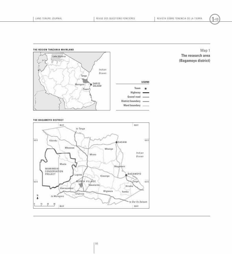
The case study is from western Bagamoyo district, in eastern Tanzania, 100–200 kilometres from Dar es Salaam. The article is based on field work carried out over three and a half months. The data is based on village and district officers’ meetings, transect walks, observations, and an analysis of land use changes based on satellite images and aerial photographs made at the GIS Laboratory of the Department of Geography, University of Turku. A household survey of 5 percent of the total population in the area, made by Ph.D. student Mr. Emmanuel Mhache from the University Dar es Salaam, supports the findings. The research carried out by a research team from the Institute of Development Studies, University of Helsinki in the same area in 1975–1981 has also provided historical background material for the study.
95
L A N D T E N U R E J O U R N A L R E v U E D E s q U E s T i O N s f O N c i è R E s R E v i s TA s O b R E T E N E N c i A D E L A T i E R R A 1 10
map 1The research area
(Bagamoyo district)
ThE BAgAmOyO DISTRICT
ThE REgION TANzANIA mAINLAND
0 10 20 30
kibindu
mbwewe
38.0 e
38.0 e 39.0 e
39.0 e
6.3 S6.3 S
6.0 S6.0 S
miono
mkange
magomeni
kiwanga
kiromo
yombowigwaza
to Dar Es Salaam
to Tanga
to Morogoro
tawalanda
lugoba
msata
wamimBikiconServationProJect
m S o g a v i l l a g e
chalinze
ubenazomozi
zinga
Sadani
Bagamoyo
n
tanga
Lake Victoria
morogoro
Pwani
dar eS Salaam
I n d i a n O c e a n
Town
highway
gravel road
District boundary
ward boundary
I n d i a n O c e a n
LEgEND
96
Juss
i Ylh
äisi
SuStainable land privatization involving participatorY land uSe planning in rural areaS an example f rom tanzania
Background
In almost all African countries, written ‘legal’ ownership of natural resources is based on colonial legislation which commonly left outside its legal protection all agriculture, animal husbandry, forestry, hunting and collection activities of African people. New land legislation should correct the above historical injustice (e.g. Koponen, 1988 and 1994), while guaranteeing sustainable land use. Re-evaluation of land legislation is also needed because of significant contextual changes affecting lands: a tripled population, depletion of the forests and fertile lands due to governance problems in land tenure, scarcity of arable land, competition between different forms of land use, biofuel production, changes in the forms of settlements, urbanization, changes from subsistence cultivation to a cash economy, and increasing global interest in the land. The impacts of climate change will also affect the productivity and value of different kinds of land and increase competition over higher value resources. Cotula et al. (2009) have estimated that over the past two years, 20 million hectares of land have been sold to foreign investors in Africa. Recently in Tanzania alone, over 3 million hectares of land have been allocated for investors (domestic and foreign); a large proportion of the land in the study villages has been allocated in relatively small parcels of 50–100 ha almost for free, in reality without investments. Many relatively small property transactions are not transparent. In the case study area there have also been land allocations of 12 000 to 20 000 ha for local and foreign investors.
The greatest motivator for a change in the recent land ownership situation is the possibility and necessity of enhancing production, income and food security for rural people, in order to motivate them to develop and cultivate the land and use natural resources sustainably (WSFS, 2009). How can this be achieved? This is a key question, given that more than half of the population of the continent derives its livelihood directly from natural resources. There are many different opinions and approaches that need to be considered, especially since the most vulnerable need to be included in the process (e.g. ILC, 2007).
The land ownership rights of african people were left outside colonial legislation
97
L A N D T E N U R E J O U R N A L R E v U E D E s q U E s T i O N s f O N c i è R E s R E v i s TA s O b R E T E N E N c i A D E L A T i E R R A 1 10
International financial institutions consider private ownership – which allows land to be used as a collateral – to be a prerequisite for rural development, and a collateral is necessary for farmers to invest in their farmlands (Soto, 2000). The World Bank may not have made such objectives explicit in its official statements; however, its actions promoting free enterprise, especially free entry of foreign capital, have given a strong impetus for African governments to deal with land tenure issues. These actions have created new competition over natural resources, between large-scale farmers and smallholders, between pastoralists and cultivators, and between forest keepers and lumber business interests. (Yoshida, 2005). However, research in Burkina Faso indicates that in this country, the driving force behind using land as collateral is the banking sector, while farmers seem to be quite sceptical about the idea (Wit et al., 2009). In Mozambique, a certificate under the customary land ownership certificate system, DUAT, (Tanner et al., 2009), developed with the support of FAO, is not accepted as collateral (Wit et al., 2009), while in Tanzania the land devolution process is strongly promoted via the idea of access to loans.
Another central issue of land tenure in many African countries is the conflict between traditional and private land ownership rights. Traditional rights are seen in many places as authoritarian: a system in which the chiefs are the main owners of land. Meanwhile privatization is seen as a competition between ordinary villagers’ rights to their cultivated lands and legitimizing the ‘feudal’ ownership rights of chiefs (e.g. Boone, 2007). In many parliaments, the devolution of land rights from the central government to already-powerful chiefs and groups of people can be difficult to legalize. This is one reason why in many African states the privatization of lands is still unsettled. The position of local chiefs in Tanzania was strengthened during the British regime, especially in matrilineal societies (Jerman, 1997). The chiefs lost their status as regards land allocation soon after Tanganyika (present day Tanzania mainland) achieved her independence in 1961. In addition, in Tanzania land use changes during the socialist Ujamaa period have changed traditional customary rights, or traditional rights overlap with new rights (e.g. Oppen, 1992; Ylhäisi, 2006). This is a confusing element in the land tenure of the local communities. Relatively recent studies such
98
Juss
i Ylh
äisi
SuStainable land privatization involving participatorY land uSe planning in rural areaS an example f rom tanzania
as Oppen (1992) suggest that customary tenure arrangements explain the unequal land distribution between the original population in an area, and those who were moved there more recently. There are also many positive examples of customary land management and land tenure cases, mainly in areas where the Ujamaa system did not have an effect (e.g. Lerise, 2005).
In any case, most of the local customary practices would need to be democratized to guarantee equal rights for women, the poor and the landless. These principles are widely accepted in official policies although the reality is commonly very different (e.g. ESCR, 2009). In Tanzania, the former chairman of the Presidential Commission of Inquiry into Land Matters (URT, 1994) Issa Shivji (1999) has written: “The issue of land tenure reform cannot be separated from the question of democracy in a country”. For a long time the tendency has been to ignore the existence of local customary structures as a basis for building new land ownership legislation. Cases exist where customary rights are also being (or have been) deliberately weakened or annulled in law (Mwihomeke et al., 1998; Wily, 2003).
When a country is moving from a single party system to a multiparty division of power (for example), without a proper policy or implementation of land devolution, and at the same time there are instructions and demands by international organizations on changing the system of land ownership, there is a danger of ‘elite capture’: people who have official control (Grover et al., 2007) or knowledge use the situation to reallocate common property to their own advantage (Raphael & Swai, 2009). Governments’ takeovers of the management of common property resources have often resulted in open-access situations in which there are no respected tenure rules (Ribot, 2003). This is happening so openly in Tanzania that the situation appears to be intentional (e.g. Nathan et al., 2007). Anyone can use the resources to his or her advantage, without constraints. When land privatization takes several years the planned devolution of rights to locals will not necessarily occur in time to prevent the loss of the natural resources.
Probably one of the most important reasons for the persistence of tenure systems created during colonial times is the difficulty of persuading land elites to give up their power: not only at the top level, but also in all offices dealing with land management. For example, in Tanzania almost one sixth of the country’s land area is under the direct management of the Forestry
During the land devolution, there is a danger of ‘elite capture’
99
L A N D T E N U R E J O U R N A L R E v U E D E s q U E s T i O N s f O N c i è R E s R E v i s TA s O b R E T E N E N c i A D E L A T i E R R A 1 10
Department, but central government revenues from lumbering in these forests have varied from 1.6 percent of the value of timber in the mid 1980s to 4 percent in 2004; the rest (96.0–98.4 percent) has disappeared (Milledge et al., 2007).
Because of low revenues from these large areas of forest, and the considerable administrative cost of official management combined with simultaneous environmental degradation and loss of natural resources, the trend since the 1980s has been to pass an increasing degree of responsibility for land use management to local communities, using participatory and joint management methods (Vihemäki, 2009). Globally, Tanzania has been an innovator in this field (see Box 4): e.g. participation via numerous schemes such as Community-Based Natural Resource Management (CBNRM), Joint Natural Resource Management (JNRM), Joint Forest Management (JFM), Community-Based Conservation Management (CBCM), and Community-Based Wildlife Management (CBWM). These management models have been fairly successful. Their success has opened up possibilities for joint management by the government and local communities, and other groups of state-owned reserves and communal areas. This process has paved the way for the use of similar approaches in overall rural development and the creation of VLUP, although it is also true to say that officials may find it difficult to change their role from controllers to extension advisors.
The official process of land devolution to local communities and individuals via participatory land use planning in TanzaniaIn Tanzania, the planning process of land legislation has involved an exceptionally open debate which started about 20 years ago in preparation for the comprehensive report by the Presidential Commission of Inquiry into Land Matters in 1992 (URT, 1994). During the debate, politicians perceived the land law more from a local community and economic perspective, and as part of a safety net, than is the case in any western tenure law, where the main aim is the owner’s security of tenure. In discussions on the Land Act 1999, the Village Land Act 1999, and supplementary acts (the latest of which is the Land Use Planning Act 2007), strengthening the capacity of elected village councils was seen as essential.
100
Juss
i ylh
äisi
SuStainaBle land Privatization involving ParticiPatory land uSe Planning in rural areaS an example f rom tanzania
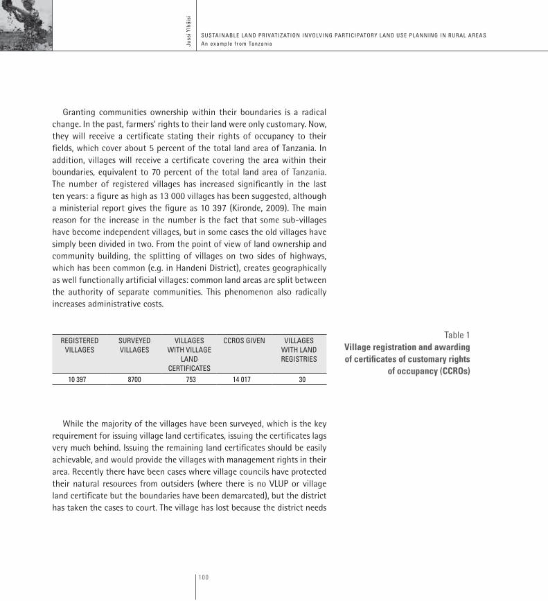
Granting communities ownership within their boundaries is a radical change. In the past, farmers’ rights to their land were only customary. Now, they will receive a certificate stating their rights of occupancy to their fields, which cover about 5 percent of the total land area of Tanzania. In addition, villages will receive a certificate covering the area within their boundaries, equivalent to 70 percent of the total land area of Tanzania. The number of registered villages has increased significantly in the last ten years: a figure as high as 13 000 villages has been suggested, although a ministerial report gives the figure as 10 397 (Kironde, 2009). The main reason for the increase in the number is the fact that some sub-villages have become independent villages, but in some cases the old villages have simply been divided in two. From the point of view of land ownership and community building, the splitting of villages on two sides of highways, which has been common (e.g. in Handeni District), creates geographically as well functionally artificial villages: common land areas are split between the authority of separate communities. This phenomenon also radically increases administrative costs.
regiStered villageS
Surveyed villageS
villageS with village
land certificateS
ccroS given villageS with land regiStrieS
10 397 8700 753 14 017 30
While the majority of the villages have been surveyed, which is the key requirement for issuing village land certificates, issuing the certificates lags very much behind. Issuing the remaining land certificates should be easily achievable, and would provide the villages with management rights in their area. Recently there have been cases where village councils have protected their natural resources from outsiders (where there is no VLUP or village land certificate but the boundaries have been demarcated), but the district has taken the cases to court. The village has lost because the district needs
table 1Village registration and awarding of certificates of customary rights
of occupancy (CCROs)
101
L A N D T E N U R E J O U R N A L R E v U E D E s q U E s T i O N s f O N c i è R E s R E v i s TA s O b R E T E N E N c i A D E L A T i E R R A 1 10
to approve the village by-laws in order for them to become legally binding, and in these cases the district has not done so. Reluctance to let go of the associated power may be one reason why the village land certificates are still in a land officer’s drawerd.
The land devolution process part of land use planning takes place at three levels: 1) national framework land use plan 2) district land use plans and 3) village land use plans (Box 1). Levels 1 and 2 are still mostly missing, which means that the few established VLUPs have been made without the guidance of levels 1 and 2.
In Tanzania only 13 districts out of 127 have finished their DLUP. In the village land use planning process, meetings leading to agreements between stakeholders to secure ownership of the land area within the village boundaries are required. Individual certificates of customary rights of occupancy are considered only as temporary titles which will be revoked once there is a VLUP. In Box 1 the six steps of the participatory VLUP process are presented.
Participatory Rural Appraisal (PRA) methods (e.g. Hatcher, 2009) assist common decisions in complex situations where there are conflicting interests. PRA provides a tool for a simultaneous consideration of socio-economic and environmental development in order to achieve changes to both. PRA makes it easier for poor, less communicative, less active and less powerful people to participate and express their opinions and needs in meetings. Here, villagers take responsibility for explaining, assessing and evaluating issues such as their situation and resources. They are helped by a facilitator so that all participants learn from each other and teach each other in an egalitarian way (e.g. Anyaegbunam et al., 2004). In Tanzania, the rural poor are thus relatively empowered during the VLUP process.
102
Juss
i ylh
äisi
SuStainaBle land Privatization involving ParticiPatory land uSe Planning in rural areaS an example f rom tanzania
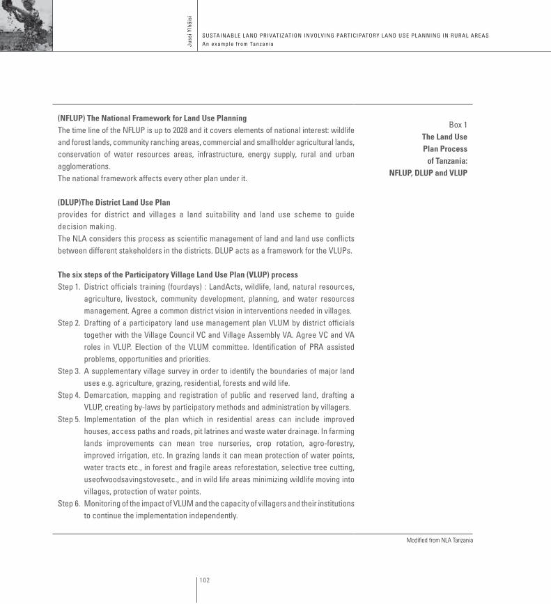
(NFLUP) The National Framework for Land Use Planningthe time line of the nfluP is up to 2028 and it covers elements of national interest: wildlife and forest lands, community ranching areas, commercial and smallholder agricultural lands, conservation of water resources areas, infrastructure, energy supply, rural and urban agglomerations.the national framework affects every other plan under it.
(DLUP)The District Land Use Planprovides for district and villages a land suitability and land use scheme to guide decision making. the nla considers this process as scientific management of land and land use conflicts between different stakeholders in the districts. dluP acts as a framework for the vluPs.
The six steps of the Participatory Village Land Use Plan (VLUP) processStep 1. district officials training (fourdays) : landacts, wildlife, land, natural resources,
agriculture, livestock, community development, planning, and water resources management. agree a common district vision in interventions needed in villages.
Step 2. drafting of a participatory land use management plan vlum by district officials together with the village council vc and village assembly va. agree vc and va roles in vluP. election of the vlum committee. identification of Pra assisted problems, opportunities and priorities.
Step 3. a supplementary village survey in order to identify the boundaries of major land uses e.g. agriculture, grazing, residential, forests and wild life.
Step 4. demarcation, mapping and registration of public and reserved land, drafting a vluP, creating by-laws by participatory methods and administration by villagers.
Step 5. implementation of the plan which in residential areas can include improved houses, access paths and roads, pit latrines and waste water drainage. in farming lands improvements can mean tree nurseries, crop rotation, agro-forestry, improved irrigation, etc. in grazing lands it can mean protection of water points, water tracts etc., in forest and fragile areas reforestation, selective tree cutting,useofwoodsavingstovesetc., and in wild life areas minimizing wildlife moving into villages, protection of water points.
Step 6. monitoring of the impact of vlum and the capacity of villagers and their institutions to continue the implementation independently.
Box 1The Land Use Plan Process
of Tanzania: NFLUP, DLUP and VLUP
Modified from NLA Tanzania
103
L A N D T E N U R E J O U R N A L R E v U E D E s q U E s T i O N s f O N c i è R E s R E v i s TA s O b R E T E N E N c i A D E L A T i E R R A 1 10
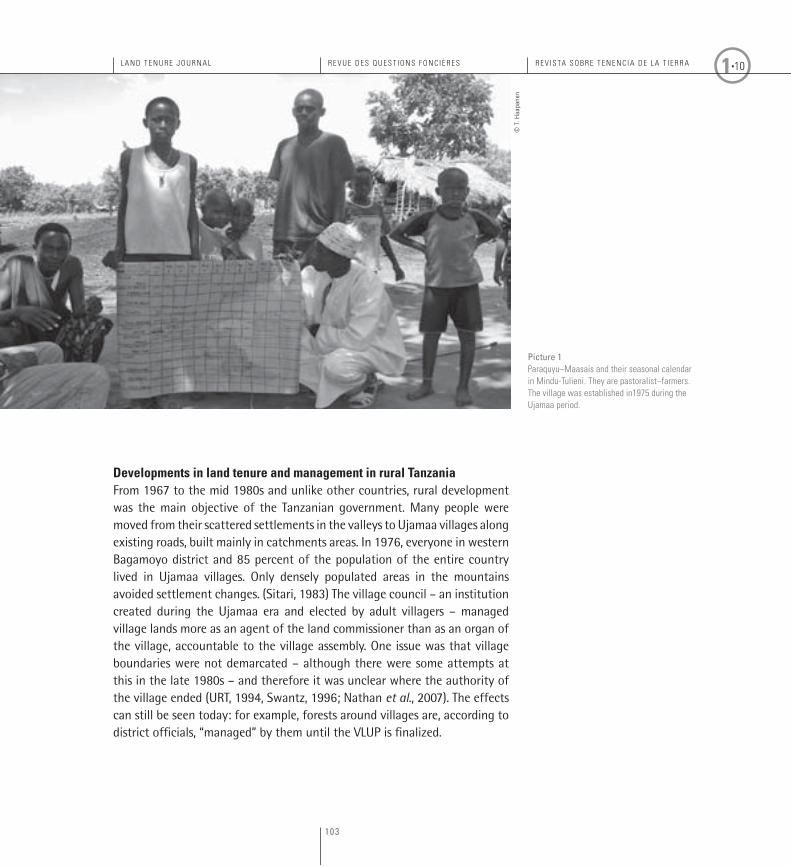
Developments in land tenure and management in rural Tanzania From 1967 to the mid 1980s and unlike other countries, rural development was the main objective of the Tanzanian government. Many people were moved from their scattered settlements in the valleys to Ujamaa villages along existing roads, built mainly in catchments areas. In 1976, everyone in western Bagamoyo district and 85 percent of the population of the entire country lived in Ujamaa villages. Only densely populated areas in the mountains avoided settlement changes. (Sitari, 1983) The village council – an institution created during the Ujamaa era and elected by adult villagers – managed village lands more as an agent of the land commissioner than as an organ of the village, accountable to the village assembly. One issue was that village boundaries were not demarcated – although there were some attempts at this in the late 1980s – and therefore it was unclear where the authority of the village ended (URT, 1994, Swantz, 1996; Nathan et al., 2007). The effects can still be seen today: for example, forests around villages are, according to district officials, “managed” by them until the VLUP is finalized.
Picture 1Paraquyu–Maasais and their seasonal calendar in Mindu-Tulieni. They are pastoralist–farmers. The village was established in1975 during the Ujamaa period.
© T
. Haa
pane
n
104
Juss
i ylh
äisi
SuStainaBle land Privatization involving ParticiPatory land uSe Planning in rural areaS an example f rom tanzania
Agriculture was organized into cooperatives, but these did not succeed. As a result of the Ujamaa policy among others, by the mid-1980s the economy was in ruins. Tanzania then underwent one of the most radical structural adjustment programmes in Africa, during which land issues were also taken into consideration again (e.g. Bagachawa & Limbu, 1995). The programme of commercializing smallholder farming, which included removing subsidies and ending cooperatives (Sokoni, 2008) resulted in stagnation and even a decrease in agricultural production in areas like western Bagamoyo. There, cotton was the main cash crop, and it disappeared without being substituted by any other cash crop.
The population in the area has substantially increased. At the same time, the productivity of the fields has decreased. The land area being farmed has remained constant from 1993 to 2004 (Haapanen & Mhache, 2009) and to the present. In this situation one would expect there to be very little money in villages, but actually there is more money than ever. The money is coming from natural resources officially ‘managed’ by the state, partly from property sales to outsiders, e.g. to biofuel, carbon trade and land investors. Entire villages, excluding settlements and subsistence farmlands, have been rented for 99 years in the neighbouring district, and many smaller land transactions have been made in the research area.
Out of a total of 4 million ha requested by companies for biofuel production, about 640 000 ha have been allocated in Tanzania. This has aroused attention from Tanzanian policy makers. Investments have affected thousands of local people, leading to the alienation of their rights over customary lands. (Sulle & Nelson, 2009). The Tanzania Investment Commission (TIC) has a mandate to identify and provide land for investors, and has allocated 2.65 million ha of land for this purpose (NLA, 2009). In Bagamoyo district, TIC has allocated about 20 plots of land to possible investors. Most of these areas are on the coast with beaches, but some are for sugarcane production for biofuel, which needs a well-watered area. People living and working in these areas are not pleased to have to move away.
According to the law villagers will be compensated fairly by the government when village land is transformed into general land (e.g. Box 2 – FAO, 2008).
105
L A N D T E N U R E J O U R N A L R E v U E D E s q U E s T i O N s f O N c i è R E s R E v i s TA s O b R E T E N E N c i A D E L A T i E R R A 1 10
In practice, investors themselves tend to pay the villagers directly. When land is not classed under the village land category, companies have compensated villagers for the value of the resources on the land, such as trees, grazing, and water sources. In northern Bagamoyo, 12 500 ha of land has been given to a private company to establish carbon trade under the Reduced Emissions from Deforestation and forest Degradation programme (REDD). According to the investor, the justification for renting the land to a private company is that the local communities do not have access to loans in order to raise the $US 40 million needed for the project. In the land archive of the district it was not possible to find information about the overall situation of the land titles in the area.
The most important source of money for the villagers, however, is the selling of charcoal. This source of income is also the most evenly distributed in the villages. Along the main highway 200 kilometres inland from Dar es Salaam, the contribution of charcoal production to household income was evaluated to be as high as circa $US 170 per year in the early 1990s (Monela et al., 1993). In Bagamoyo district, forests along the highways have been cut for charcoal and sold in Dar es Salaam. Similar situations are being
In Tanzania there are three different categories of land:1. Reserved lands, which cover 28 percent of the land area (forests, national
parks, game reserves, and for infrastructure development). According to new forest and wildlife acts, joint management in these government areas is possible. These areas are unoccupied.
2. Village lands, which cover some 70 percent of the total land area of Tanzania, accommodating 80 percent of the population.
3. General lands (2 percent of the total land area) consisting mainly of urban areas and accommodating 20 percent of the population (Kironde, 2009; TIC, 2008). According to the law, if an investor wants to buy a land area from a village, the category of this land will change to general land and it will receive a government land title.
Box 2Categories of Land
in Tanzania
106
Juss
i ylh
äisi
SuStainaBle land Privatization involving ParticiPatory land uSe Planning in rural areaS an example f rom tanzania
reported all over the country (e.g. Strömquist & Backéus, 2009; Drigo 2005). According to a case study survey by Mhache, in 2008 almost 20 percent of households were involved in illegal charcoal making, though in reality the true percentage is probably much higher. In one village meeting in Msata, attended by members of the village council and it’s natural resources committee, the general opinion was that almost every family participates in charcoal making: Near a growing city such as Dar es Salaam this is a lucrative business. Some publications have cited this as a form of income redistribution from urban centres to rural areas. However, this is realized at the expense of forests and the environment; according to Mwampamba (2007), forests on public land could be depleted by 2028.
At present in Bagamoyo district, forests have been cut from areas where it has been possible to transport the products. By whom and for what reason is this happening? District and divisional forest officials may say: “We need to feed the cities. Everyone is using charcoal in the cities. This is a problem, but there are no alternatives.” The sector ministry’s policy developer may also say the same: “Cities and people need cheap energy; there is nothing that can be done about it.” Nothing? “We have plans to regulate the charcoal selling sites in the new policy so that the approximate distance between sales points is about 10 kilometres.” (Interview, December 2008) At the same time, in the report of Halmashauri (2008) to the district council on district forests it is stated that: “All communities depend on forest resources as a source of income and this causes a great loss of forest. Charcoal making has spread everywhere. In the villages and institutions knowledge and understanding of various forms of forest ownership is lacking. Also data on forests is limited, and this is a hindrance in forest management.”
At the same time, villagers are under the impression that they do not have legal instruments to protect their forests, and that village forest reserves (VFR) cannot be established without a VLUP process. Their belief is based on information given by the forest officials, but when queried about it foresters agreed that a VLUP is not necessary. Also, villagers believe that VFRs are established so that the villagers may plant trees in them. The villagers are under the impression that VFRs cannot be utilized. When the
107
L A N D T E N U R E J O U R N A L R E v U E D E s q U E s T i O N s f O N c i è R E s R E v i s TA s O b R E T E N E N c i A D E L A T i E R R A 1 10
aims of the forest law and policy – to create VFRs as a source of natural resources for communities – are explained to people, they start to show some interest (Ylhäisi, 2003). However, creating VFRs owned and managed by villagers requires that village boundaries should be defined. When asking an experienced former government forester why (in this environmental situation) the policies are not implemented, the answer given is: “The idea of participatory village forest reserves is only another way to ‘mislead’ villagers to perform free work.” (Interview, November 2008) At the same time, nearly half of the national budget for the fight against environmental degradation is allocated to land use planning (NLA, 2009). This indicates that the central government acknowledges the power of ownership rights as a key to environmental protection. A VLUP also involves substantial environmental education and planning, based on principles of sustainable development. For example, the results of village land use planning in Kisarawe are positive: with VLUPs in place, nearly all villages are constructing their own village land registries. All villages have their VLUP displayed in their offices and have developed by-laws, but the most important result is that “the rate of deforestation has been reduced by 90 percent”. (NLA, 2009).
There is a contradiction between the attitude of the foresters and the official policy. Similarly there is a contradiction between the environmental destruction which can be identified by remote sensing from satellite images and by field transects walks, and the observations of local, ward and district officials. There is also a contradiction between the national budget – where money is allocated for land use planning (land devolution) – and the government allowing young men to engage in self-employment, making charcoal. There is a lack of law enforcement as regards natural resource management (Madulu, 2005), and it is increasingly clear that, in practice, there is an open access approach to natural resources. In Bagamoyo and elsewhere, there are ‘hidden’ villages full of young charcoal makers and their families. When the forests have been cut and there is no more self-employment in charcoal making,finding alternative livelihoods will be a major challenge, as will be cheap energy for the cities.
Whatever the circumstances, there will be a large permanent loss of biodiversity. Fortunately there are still some traditionally protected forests
Almost half of the budget for the fight against environmental degradation is allocated to land use planning
108
Juss
i ylh
äisi
SuStainaBle land Privatization involving ParticiPatory land uSe Planning in rural areaS an example f rom tanzania
(TPFs) – even in badly eroded areas – which have always been rich in species (Mwihomeke et al. 2000). Under the VLUP process the facilitators also advise villagers to protect their TPFs. In each completed VLUP there are about 20 small TPFs which are now officially protected.
State of the art in Bagamoyo districtThere are too few people qualified in the VLUP process, and the work would take years even if the money for it were available; now, after the demarcation of the village boundaries, the limiting factor has been money. In Bagamoyo, there is only a draft VDLUP. In January 2010, the plan was almost ready when the laptop computer containing it was stolen. There are already 19 villages with a VLUP. In practice, the few completed VLUPs are in villages where there have been serious conflicts between pastoralists and farmers. The 13 villages under the Wamimbiki wildlife conservation project (Box 3) are those where the investor has paid for the work, and has an option to lease the land after the VLUP is finalised; this is the way investors are also acquiring land in Mozambique (Wit et al., 2009).
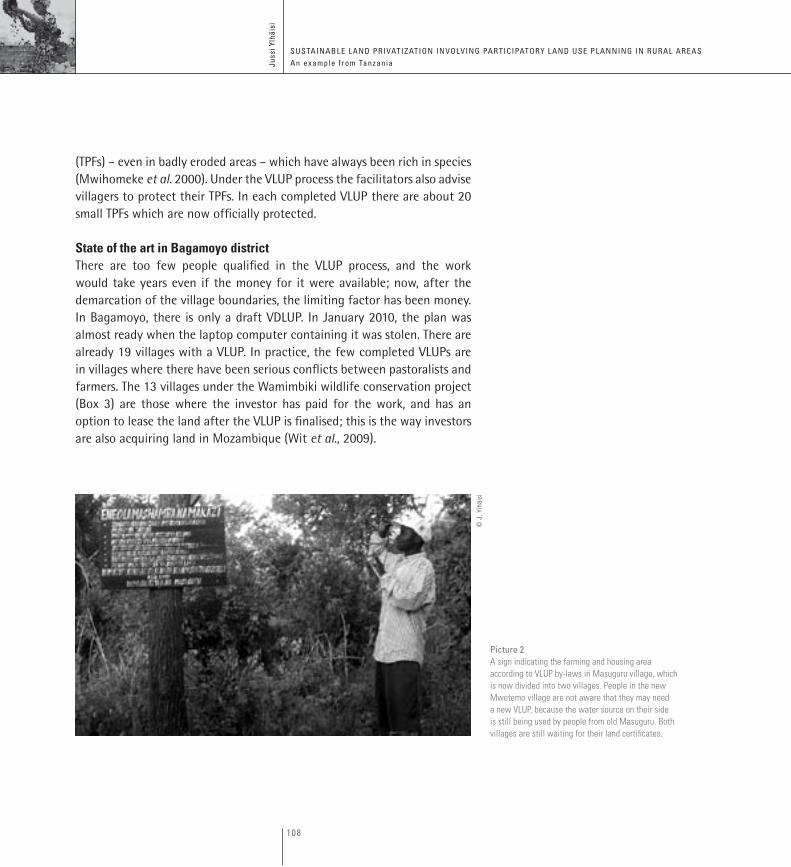
Picture 2A sign indicating the farming and housing area according to vLUP by-laws in Masuguru village, which is now divided into two villages. People in the new Mwetemo village are not aware that they may need a new vLUP, because the water source on their side is still being used by people from old Masuguru. both villages are still waiting for their land certificates.
© J
. Ylh
äisi
109
L A N D T E N U R E J O U R N A L R E v U E D E s q U E s T i O N s f O N c i è R E s R E v i s TA s O b R E T E N E N c i A D E L A T i E R R A 1 10
a danish hunting association, in association with the surrounding villages, protects 2500 km2 of forest along the western boundary of Bagamoyo. the 13 participating villages in Bagamoyo and 11 in morogoro region benefit in different ways. all of them receive an annual fee of one million tanzanian shillings. the association has also paid for the preparation of the village land use Plans (vluPs) and land register offices in these villages. the cost of the vluP in 2005 was 120 million tsh, and the process took 6 months. the land certificates have not yet arrived from the government, but all the villages are expecting them to be delivered at any moment. villagers have to forgo access to their own hunting, fishing and gathering areas. the project is organizing photography excursions, including lodging for nature and animal lovers to make it economically sustainable. environmentally, the project has been a success: 3000 km2 of natural forests have been protected, although there are also problems (madulu, 2005). this kind of a joint wildlife management and Jfm, which started 11 years ago, is a relatively new method of managing wildlife outside parks and reserves. the project is a clear recognition of community entitlements to rural land resources (Brockington, 2007; Schroeder, 2008).
Box 3The wamimbiki wildlife
conservation project
The total area of Bagamoyo district is 9847 km2. The planned farming area in the draft DLUP is 5767 km2: seven times larger than the existing farming area. Only 7 km2 is irrigated at the moment, and 164 km2 is offered to investors for establishing irrigation farming. The land area for livestock is 1700 km2, but only 20 percent of it is in use at present. The area for protection of water sources and use is 855 km2. According to the plan, the area reserved for forests in the district is only 347 km2. (Halmashauri, 2008). Implementing the plan will mean a very large permanent environmental change in the district.
In the district there are 82 villages, and the boundaries of 79 of these had been demarcated in 2007. (The three undefined villages are neighbours to Sadani National Park (578 km2); the villages have not accepted the demarcation of the boundaries of the park.) In Bagamoyo the average size of a village is 110 km2. The boundaries between the villages have been defined by an average of 10 boundary posts. (In addition, 60 percent of the
110
Juss
i ylh
äisi
SuStainaBle land Privatization involving ParticiPatory land uSe Planning in rural areaS an example f rom tanzania
villages have a river defining some parts of their boundary. Perennial rivers are always boundaries for villages.) (Plans, 2007)). In practice, this means that dividing lines between boundary posts are straight, and consequently many farms are divided by a boundary between two villages. Recently there have been cases where the part of the farmer’s land found in another village has been sold to investors by the other village, because the farmer only has a right to land in the village where she or he lives.
During the VLUP process the facilitating team makes proposals for multiple land use systems. Conflicts between pastoralists and farmers are the most difficult: lives have even been lost. Pastoralists in general are, according to the NLUP Committee (NLA, 2009), “a highly vulnerable group which should be carefully handled under the Village Land Act implementation due to threats from farmers who tend to disregard this mode of production”. The pastoralists have been quite content with the VLUP process in Bagamoyo district because it legitimizes their rights to land use, although in every village where the VLUP has been finished the grazing areas have became smaller than before. In many villages, the presence of Maasais peoples is less than 20 years old. The reason for local farmers’ agreement to VLUPs is the advice of facilitator teams, who tell them that this will bring in regulations concerning where the Maasais will not be allowed to herd their cattle. Farmers are advised that the situation will be an improvement on the present one. In some areas in Bagamoyo district, pastoralists are newcomers: a result of the open access situation in Tanzania. In most of the district pastoralists take their cattle to the forest areas that have been cut.
Attitudes of local officials and members of the village natural resources committees towards the VLUP process are still positive, but there is some frustration because of delays with promised certificates. Individual sacrifices have been made by families that have moved to a correct land use area from another area, as part of the implementation of the plan. In Box 4, sample results of a participatory VLUP meeting are presented. After the VLUP process in Msoga village, villagers are still expecting to receive their land certificate and a land archive has been built in a corner of the village square. Land prices have increased in the village after the devolution of rights, and they are now higher than in the division centre 10 kilometres
111
L A N D T E N U R E J O U R N A L R E v U E D E s q U E s T i O N s f O N c i è R E s R E v i s TA s O b R E T E N E N c i A D E L A T i E R R A 1 10
away. According to the village chairman (Meeting, December 2008) the only negative aspect following the process has been an increase in quarrels about boundaries between neighbours in the village. (Manara (2008) Similar reports haves been heard in insimilar reports, in the neighbouring Handeni district.) Pastoralists are still entering the existing farming areas proposed for irrigation (Interview, February 2010).
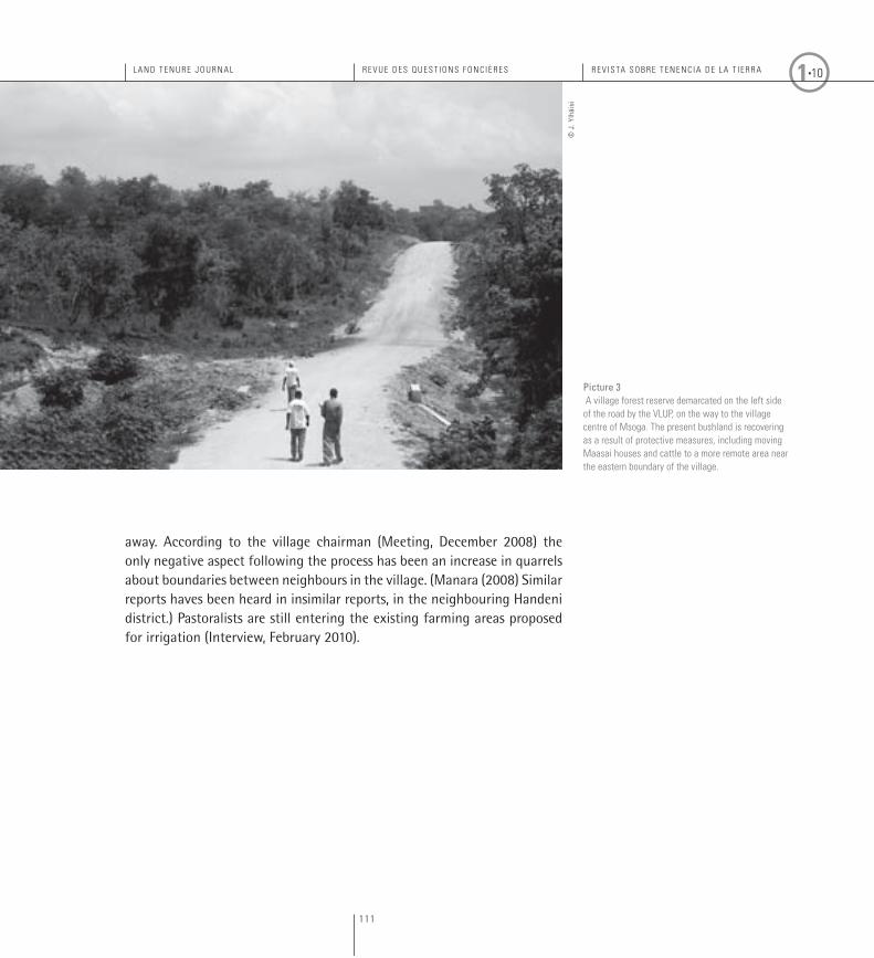
Picture 3 A village forest reserve demarcated on the left side of the road by the vLUP, on the way to the village centre of Msoga. The present bushland is recovering as a result of protective measures, including moving Maasai houses and cattle to a more remote area near the eastern boundary of the village.
© J
. Ylh
äisi
112
Juss
i ylh
äisi
SuStainaBle land Privatization involving ParticiPatory land uSe Planning in rural areaS an example f rom tanzania
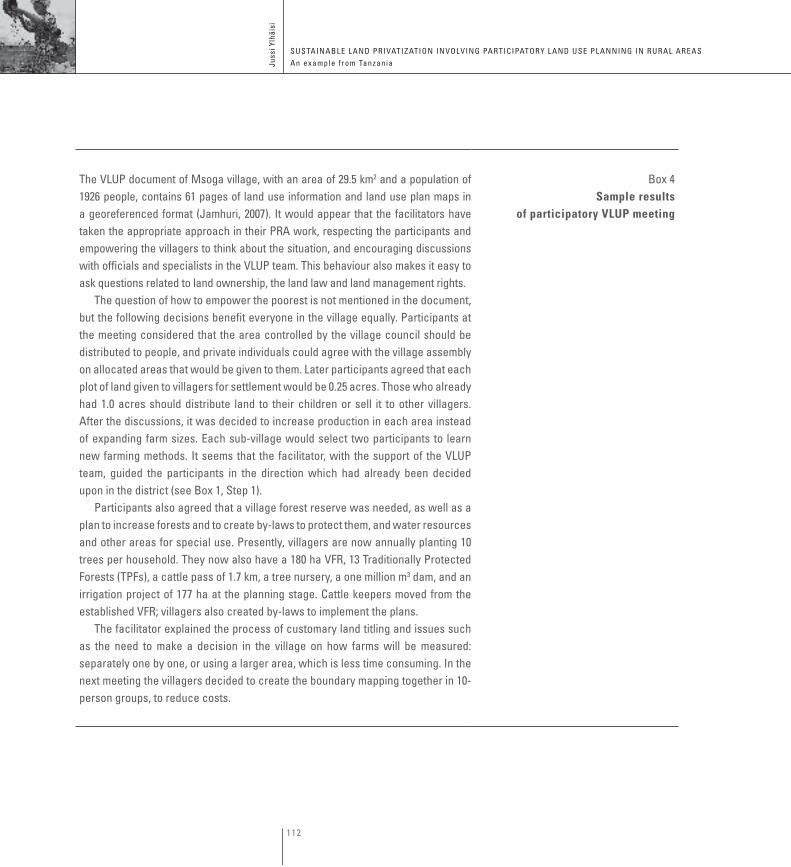
the vluP document of msoga village, with an area of 29.5 km2 and a population of 1926 people, contains 61 pages of land use information and land use plan maps in a georeferenced format (Jamhuri, 2007). it would appear that the facilitators have taken the appropriate approach in their Pra work, respecting the participants and empowering the villagers to think about the situation, and encouraging discussions with officials and specialists in the vluP team. this behaviour also makes it easy to ask questions related to land ownership, the land law and land management rights.
the question of how to empower the poorest is not mentioned in the document, but the following decisions benefit everyone in the village equally. Participants at the meeting considered that the area controlled by the village council should be distributed to people, and private individuals could agree with the village assembly on allocated areas that would be given to them. later participants agreed that each plot of land given to villagers for settlement would be 0.25 acres. those who already had 1.0 acres should distribute land to their children or sell it to other villagers. after the discussions, it was decided to increase production in each area instead of expanding farm sizes. each sub-village would select two participants to learn new farming methods. it seems that the facilitator, with the support of the vluP team, guided the participants in the direction which had already been decided upon in the district (see Box 1, Step 1).
Participants also agreed that a village forest reserve was needed, as well as a plan to increase forests and to create by-laws to protect them, and water resources and other areas for special use. Presently, villagers are now annually planting 10 trees per household. they now also have a 180 ha vfr, 13 traditionally Protected forests (tPfs), a cattle pass of 1.7 km, a tree nursery, a one million m3 dam, and an irrigation project of 177 ha at the planning stage. cattle keepers moved from the established vfr; villagers also created by-laws to implement the plans.
the facilitator explained the process of customary land titling and issues such as the need to make a decision in the village on how farms will be measured: separately one by one, or using a larger area, which is less time consuming. in the next meeting the villagers decided to create the boundary mapping together in 10-person groups, to reduce costs.
Box 4Sample results
of participatory VLUP meeting
113
L A N D T E N U R E J O U R N A L R E v U E D E s q U E s T i O N s f O N c i è R E s R E v i s TA s O b R E T E N E N c i A D E L A T i E R R A 1 10
CONCLUSION
The Tanzanian model has a number of interesting features:1. The fields used by the villagers become their legal property.2. At the same time, communal ownership applies to the rest of the village area.3. Part of the communal land remains pooled and can be tapped when
there is a new need for plots.4. Land use zones have been defined.
These features make the model an attractive alternative: a democratic community ownership of land, combining a private land ownership system with the needs of modern societies and economies. The system also provides the flexibility to allow for adaptation to future situations that as yet cannot be predicted, such as changes in agricultural methods (e.g. tractors) and climate change (e.g. REDD). Large grazing areas may become obsolete (e.g. because of greenhouse emissions), or they may even become the main source of livelihood (e.g. because of changes in vegetation). The food price spike recently experienced may be repeated, or the demand for bioenergy may rise. However, it is important that the process of producing VLUPs, which in practice is stagnated, is speeded up.
To counter the recent situation of open access to natural resources, a faster method for first aid than VLUP is required. It is positive that village boundaries have been defined almost everywhere in Tanzania; this has been a long-winded and expensive part of the land devolution process. The emphasis should now be on guaranteeing that the land inside village boundaries belongs to the villagers. A village land certificate should be effective up to the time when the VLUP has been completed. The village certificate should be sent immediately to every surveyed village, giving them the legal right to protect their environment, natural resources and ownership.
This allows communities to avoid land grabbing by their own members as well as by outsiders. It also helps to avoid group movements from overpopulated areas or overgrazed areas, which are sometimes organized by powerful people in the state administration.
114
Juss
i ylh
äisi
SuStainaBle land Privatization involving ParticiPatory land uSe Planning in rural areaS an example f rom tanzania
The most promising result of the VLUP process is that the rate of deforestation has been reduced by 90 percent in villages where a VLUP has been completed. “VLUPs will affect the lifestyles of the people”, promised the NLA in 2009. Increased rights of villagers come with increased responsibilities, and result in a higher commitment to the management of common lands, forests, and grazing areas. Relationships between pastoralists and farmers will improve, due to clear land zoning: a comprehensive plan separates farmlands from cattle and grazing areas, and fenced cattle passes are connected to grazing areas. A combination of common and private land ownership will allow more opportunities socially and economically, providing safety nets and resources for the poorest members of society.
ACkNOwLEDgEmENTS
The author is grateful to the editors of the Journal, the referees and to the Academy of Finland for their support.
115
L A N D T E N U R E J O U R N A L R E v U E D E s q U E s T i O N s f O N c i è R E s R E v i s TA s O b R E T E N E N c i A D E L A T i E R R A 1 10
© f
AO
/A. c
onti
116
Juss
i ylh
äisi
SuStainaBle land Privatization involving ParticiPatory land uSe Planning in rural areaS an example f rom tanzania
REFERENCES
Anyaegbunam, C., &P. Metafalopulos, & T. Moetsabi,. 2004. Participatory rural communication appraisal: Starting with the people. A handbook (2nd edition). Rome. FAO. 160 pp.
Bagachawa, M.S.D. & F. Limbu eds.1995. Policy reform and the environment in Tanzania. Dar es Salaam, Tanzania. Dar es Salaam University Press. 328 pp.
Boone, C. 2007. Constitutional order: Land tenure reform and the future of the African state. African Affairs Vol 106(425): 557–586.
Brockington, D. 2007. Forests, community conservation, and local government performance: The village forest reserves of Tanzania. Society & Natural Resources Vol 20(9): 835–848.
Cotula, L., et al. S. Vermeulen, R. Leonard, & J. Keeley. 2009. Land grab or development opportunity? Agricultural investment and international land deals in Africa. Rome. FAO, IIED & IFAD. 120 pp.
Drigo, R. 2005. WISDOM – East Africa. Woodfuel Integrated Supply/Demand Overview Mapping (WISDOM) methodology: Spatial woodfuel production and consumption analysis of selected African countries. Rome. FAO – Forestry Department – Wood Energy. 78 pp.
ESCR. 2009. Resource page on women’s housing and land rights. Available at: www.escr-net.org/resources/resources_show.htm?doc_id=425194 (10.9.2009)
FAO. 2008. Compulsory acquisition of land and compensation. Rome. FAO Land Tenure Studies 10. 58 pp.
Grover, R. et al, M.-P. Törhönen, D. Palmer, & P. Munro-Faure. 2007. Good governance in land administration and land tenure. Land Reform, Land Settlement and Cooperatives 2007/2:pp. 7–17.Rome. FAO.
Haapanen, T. & E. Mhache. 2009. Food systems and deforestation in eastern Tanzania: How the shift from subsistence food system to market-based food system relates to loss of forest cover in Lugoba ward, Bagamoyo district. Trondheim, Norway. Presented at Nordic Africa Days, 1–3 October 2009. University of Turku and University of Dar es Salaam. 18 pp.
Halmashauri ya Wilaya ya Bagamoyo. 2008. Taarifa za Kiasi cha Aridhi Wilayani Bagamoyo. Kumb BG/DC/F30/3/11. Bagamoyo. Bagamoyo District. 8 pp.
Hatcher, J. 2009. Dialogue, concensus and vision: Participatory and negotiated territorial development – more than a methodology – a strategy for territorial interaction and intergration. Rome. FAO. Land Tenure Working Paper 12. 29 pp.
ICL. 2007. Strategic framework 2007–2011. Putting a pro-poor land agenda into practice. Rome. International Land Coalition. 19 pp.
117
L A N D T E N U R E J O U R N A L R E v U E D E s q U E s T i O N s f O N c i è R E s R E v i s TA s O b R E T E N E N c i A D E L A T i E R R A 1 10
Jamhuri. 2007. Mpango wa Matumizi Bora ya Arhidi ya Kijiji cha Msoga, Kata ya Lugoba. Jamhuri ya Muungano wa Tanzania, Ofisi ya Waziri Mkuu, Tawala za Mikoa na Serikali za Mitaa, Halmashauri ya Wilaya ya Bagamoyo, Halmashauri ya Kijiji cha Msoga. Bagamoyo. Bagamoyo District. 61 pp.
Jerman, H. 1997. Between five lines: The development of ethnicity in Tanzania with special reference to western Bagamoyo district. Uppsala, Sweden. Nordic Africa Institute. 361 pp.
Kironde, J.M.L. 2009. Improving land sector governance in Africa: Case, Tanzania. Presentation at: Workshop on land governance in support of the MDGs – Responding to new challenges. Washington, DC. 9–10 March 2009. Dar es Salaam, Tanzania. Ardhi University. 29 pp.
Koponen, J. 1988. People and production in late precolonial Tanzania. Studia Historica 28. Jyväskylä, Finland. Gummerus. 434 pp.
Koponen, J. 1994. Development for exploitation. German colonial policies in mainland Tanzania, 1884–1914. Finnish Historical Society: Studia Historica 49. Helsinki & Hamburg. Lit Verlag. 740 pp.
Lerise, S.F. 2005. Politics in land and water management: Study in Kilimanjaro, Tanzania. Dar es Salaam, Tanzania. Mkukina na Nyota Publishers. 199 pp.
Madulu, N.F. 2005. Environment, poverty and health linkages in the Wami river basin: A search for sustainable water resource management. Physics and Chemistry of the Earth Vol 30: 950–960.
Manara, K. 2008. The paradox of property and business formalization in Tanzania. KEPA’s working papers 22. Helsinki. 24 pp.
Milledge, S.A.H. ,& I.K. Gelvas, & A. Ahrends. 2007. Forestry, governance and national development: Lessons learned from a logging boom in southern Tanzania. Dar es Salaam, Tanzania. TRAFFIC East/Southern Africa / Tanzania Development Partners Group / Ministry of Natural Resources of Tourism. 252 pp.
Monela, G., A. & O’Kting’ati, & B.M. Kiwele. 1993. Socio-economic aspects of charcoal consumption and environmental consequences along the Dar es Salaam–Morogoro highway, Tanzania. Forest Ecology and Management Vol 58: 249–258.
Mwampamba, T.H. 2007. Has the woodfuel crisis returned? Urban charcoal consumption in Tanzania and its implications to present and future forest availability. Energy Policy 35: 4221–4234.
Mwihomeke, S.T., T.H. Msangi, C.K. Mabula, J. Ylhäisi, & K.C.H. Mndemeet a.l. 1998. Traditionally protected forests and nature conservation in the North Pare mountains and Handeni district, Tanzania. Journal of East African Natural History Vol 87: 279–290.
118
Juss
i ylh
äisi
SuStainaBle land Privatization involving ParticiPatory land uSe Planning in rural areaS an example f rom tanzania
Mwihomeke, S., & C. Mabula, ,& M. Nummelin,. 2000. Plant species richness in the traditionally protected forests of the Zigua, Handeni district, Tanzania. In: Virtanen, P. & M. Nummelin, eds: Forests, chiefs and peasants in Africa – Local management of natural resources in Tanzania, Zimbabwe and Mozambique. Silva Carelica Vol 34: 178–193.
Nathan, I., . et alJ.F. Lund, Q. Gausset, & S.K. Andersen. 2007. On the promises of devolution overcoming the constraints of natural resources management in a village in Tanzania. InThe Journal of Transdisciplinary Environmental Studies Vol 6:1. 15 pp.
NLA. 2009. National Land Use Planning Commission. (Available at:http://www.nlupc.co.tz/aboutus.php) (Sited 25.5.2009.)
Oppen, A. 1992. Land rights and their impact on individual and communal forms of land use in the project area of the Handeni Integrated Agroforestry Project: consultancy study for the GTZ. Berlin. GTZ. 85 pp.
Plans. 2007. Survey of villager boundaries at Bagamoyo District, Coast Region, E768, E768/3, E768/4, E768/6, Registered plans 44943, 44949, 44946, 44947, 8.1.2007. Regional Secretariet Surveyor Coast Region. Kibaha.
Raphael, T. & G. Swai., 2009. The impacts of participatory forest management and local people’s perceptions on its implementation at the village level in Mufindi district, southern Tanzania highlands. In Nshubemuki, L., S.A.O. Chamshama, L. Mbwambo, & C. Balama et al.eds. Proceedings of the first Participatory Forestry Management (PFM) research workshop: Participatory forest management for improved forest quality, livelihood and governance. Morogoro. TAFORI. 133–146 pp.
Ribot, J.C. 2003. A theory of access. Rural Sociology Vol 68(2): 153–181.
Schroeder, R.A. 2008. Environmental justice and the market: the politics of sharing wildlife revenues in Tanzania. Society & Natural Resources Vol 21(7): 583–596.
Shivji, I.G. 1999. Protection of peasant and pastoral rights in land: A brief review of the bills for the Land Act, 1998 and the Village Land Act, 1998. Dar es Salam, Tanzania.
Sitari, T. 1983. Settlement changes in the Bagamoyo district of Tanzania as consequence of villagization. Fennia Vol 161: 1–90.
Sokoni, C.H. 2008. Commercialization of smallholder production in Tanzania: Implications for sustainable resource management. Geographical Journal Vol 174(2): 149–175.
Soto, H. 2000. The mystery of capital: Why capitalism triumphs in the west and fails everywhere else. London. Transworld Publishers. 243 pp.
Strömquist, L. & I. Backéus. 2009. Integrated landscape analyses of change of miombo woodland in Tanzania and its implication for environment and human livelihood. Geogr. Ann. Vol 91A(1): 31–45.
119
L A N D T E N U R E J O U R N A L R E v U E D E s q U E s T i O N s f O N c i è R E s R E v i s TA s O b R E T E N E N c i A D E L A T i E R R A 1 10
Sulle, E. & F. Nelson. 2009. Biofuels, and land access and rural livelihoods in Tanzania. London. IIED. 84 pp.
Swantz, M.-L. 1996. Village development: Whose conditions? In Swantz, M.-L. & A.M.Tripp eds. What went right in Tanzania? Peoples response to directed development. Dar es Salaam University Press. 137-173 pp.
Tanner, C., & P.D. Wit, & S., Norfolk. 2009. Participatory land delimitation: An innovative development model based upon securing rights acquired through customary and other forms of occupation. Land Tenure Working Paper 13. Rome. FAO. 56 pp.
Tanzania Investment Centre. 2008. Tanzanian investment guide 2008 and beyond. Dar es Salaam, Tanzania. 69 pp.
Government of the United Republic of Tanzania. 1994. Report of the Presidential Commission of Inquiry into land matters, land policy and land tenure structure. Dodoma. 350 pp.
Vihemäki, H. 2009. Participation or further exclusion? Contestations over forest conservation and control in the East Usambara mountains, Tanzania. Helsinki. Interkont Books 18 / IDS University of Helsinki. 232 pp.
Wily, L.A. 2003. Community-based land tenure management: Questions and answers about Tanzania’s new Village Land Act,1999. London. IIED. Issue Paper No.120. 68 pp.
Wit, P.D. &, C. Tanner, & S. Norfolk. 2009. Land policy development in an African context: Lessons learned from selected experiences. Rome. FAO. Land Tenure Working Paper 14. 82 pp.
WSFS. 2009. Feeding the world, eradicating hunger – Executive summary. World Summit on Food Security, Rome 16–18 November. Rome. FAO. WSFS 2009/INF/2.
Ylhäisi, J. 2003. Forest privatization and the role of community in forests and nature protection in Tanzania. Environmental Science & Policy Vol 6: 279–290.
Ylhäisi, J. 2006. The change of traditionally protected forests and leadership in Zigua ethnic group, Tanzania. Helsinki. Publicationes Instituti Geographici Universitas Helsingensis A139. 68 pp.
Yoshida, M. 2005. Land tenure reform under the economic liberalization regime: Observations from the Tanzanian experience. Africa Development–Senegal Vol 30(4): :139–150.
>>©
s. R
amas
amy