Embed Size (px)
Citation preview
Ministère de l’Écologie, du Développement durable et de l’Énergie
www.developpement-durable.gouv.frwww.developpement-durable.gouv.fr
Ministry of Ecology, Sustainable Development and Energy
General directorate for Development, Housing and Nature
Landscape office
Sequoia tower92055 La Défense cedex
Tel.: +33 (0)1 40 81 21 22
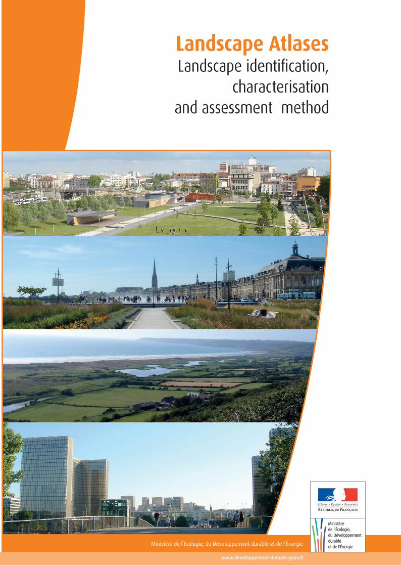
Landscape AtlasesLandscape identification,
characterisation and assessment method
conception graphique de la couverture et impression : MEDDE/SPSSI/ATL2imprimé sur du papier certifié écolabel européen
Landscape Atlases Landscape identification, characterisation and assessment method
Project coordinator
Aurélie FRANCHI – DGALN / DHUP / Landscape and publicity office
Authors/Contributors
Richard RAYMOND, Director of Research,
Yves LUGINBÜHL, Senior Research Emeritus at the CNRS, co-author of the European Landscape Convention,
Jean-François SEGUIN, Council of Europe Expert on the European Landscape Convention,
Quentin CEDELLE, contract Research Engineer and Landscape Engineer.
Hélène GRARE, Landscape Engineer and Cartographer Geomatician.
Proofreaders (members of the steering committee)
Stéphane BERTIN, Myriam BOUHADDANE-RAYNAUD, Jean-Luc CABRIT, Adrien COUTANCEAU, Mireille DECONINCK, Jacques DEVAL, Jean DOUCET, Mireille FALQUE, Aurélie FRANCHI, Thibaut GABORIT, Julien GANDAR, Yves HELBERT, Daniel LAROCHE, Hélène LEBLOND, Laetitia MANTZARIAS-CONREAUX, Claire MIEGE, Jean-Philippe MINIER, Françoise PELISSIER, Jean-Claude RENAUD, Justine RIGAULT, Michaël RIPOCHE, Muriel SAINT SARDOS, François SALGE, Jean-Pierre SAURIN, Elise SOUFFLET, Jean-Philippe STREBLER, Marie VILLOT,
as well as Isabelle ARTS, Carole CONSTANS-MARTIGNY, Philippe DORNOY, Perrine LAON, Sébastien GIORGIS, Laurence LE DU-BLAYO and Yves MICHELIN.
Cover photograph: Marie VILLOT
ISBN: 978-2-11-139389-9
Important: This publication is a translation of "Les atlas de paysages, méthode pour l’identification, la caractérisation et la qualification des paysages" (Landscape atlases - a method for identifying, characterising and describing landscapes), by Richard Raymond, Yves Luginbuhl, Jean-François Seguin, Quentin Cedelle and Hélène Grare, published in March 2015 (ISBN no. 978-2-11-139325-7). In the event of differences between the original French version and the English translation, the French version shall prevail.

Landscape Atlases - Landscape identification, characterisation and assessment method
1
Contents
Preface .................................................................................................................................................................3
Introduction .........................................................................................................................................................5
ALL LANDSCAPES ARE WORTHY OF ATTENTION ........................................................................................................5 LANDSCAPE, AN OVERARCHING VISION OF THE AREA ...............................................................................................5 LANDSCAPES: TOOLS FOR TERRITORIAL DEVELOPMENT ...........................................................................................6 AN IMPORTANT PART OF PEOPLE'S SURROUNDINGS .................................................................................................6
1- What is a Landscape Atlas? ..........................................................................................................................7
THE LANDSCAPE ATLAS, AN INFORMATION TOOL ......................................................................................................7 What landscape atlases are not ................................................................................................................................. 8
WHO IS A LANDSCAPE ATLAS FOR? FOR WHAT PURPOSE? .......................................................................................8 A landscape atlas to guide public action .................................................................................................................... 9 A landscape atlas to raise awareness among regional stakeholders ......................................................................... 9 A landscape atlas to capitalise on reusable knowledge ........................................................................................... 10 A landscape atlas to promote public participation .................................................................................................... 10
WHY UPDATE A LANDSCAPE ATLAS EVERY 10 YEARS? .......................................................................................... 11 THE 1994 LANDSCAPE ATLAS METHOD ............................................................................................................... 12
The structure of the proposed approach .................................................................................................................. 12 Feedback on twenty years of experience of landscape atlases................................................................................ 13 Specifying the context and the choices made .......................................................................................................... 16 Having a consistent level of knowledge between the landscape atlases .................................................................. 16 Reporting the information and making it available .................................................................................................... 17
2- Organisation for producing a landscape atlas ......................................................................................... 19
ORGANISING AND DISTRIBUTING ROLES BETWEEN THE PARTNERS ......................................................................... 19 Contracting authority ................................................................................................................................................ 20 Project management ................................................................................................................................................ 20 Steering committee .................................................................................................................................................. 21 Monitoring committee ............................................................................................................................................... 22 Coordination committee ........................................................................................................................................... 22
PREPARING FOR THE CREATION OR UPDATE OF A LANDSCAPE ATLAS..................................................................... 22 The sharing of objectives ......................................................................................................................................... 23 Formalisation of the specifications ........................................................................................................................... 24
3- Creating or updating a landscape atlas .................................................................................................... 27
THE DIFFERENT SCALES TO CONSIDER................................................................................................................. 27 Geographic scales .................................................................................................................................................... 27 Landscape processes and time scales ..................................................................................................................... 27
THE ORGANISATION OF LANDSCAPE KNOWLEDGE ................................................................................................. 28 Characterising a landscape ...................................................................................................................................... 29 Assessing a landscape ............................................................................................................................................. 35 Identifying a landscape ............................................................................................................................................. 38 Landscape processes .............................................................................................................................................. 41 Landscape issues ..................................................................................................................................................... 44 The study area, landscape units and landscape unit groupings ............................................................................... 45
Landscape Atlases - Landscape identification, characterisation and assessment method
2
VALIDATING THE KNOWLEDGE PRODUCED ............................................................................................................ 47 LANDSCAPE ATLAS REQUIREMENTS ..................................................................................................................... 48
Requirements at study area level ............................................................................................................................. 48 Landscape unit groupings ........................................................................................................................................ 49 Requirements at the level of each landscape unit .................................................................................................... 51 Landscape unit profile .............................................................................................................................................. 52
4- Distributing and exploiting the knowledge acquired .............................................................................. 53
THE DIFFERENT LANDSCAPE ATLAS EXPLOITATION FORMATS ................................................................................ 53 LANDSCAPE ATLAS STYLE AND CONTENT ............................................................................................................. 54
A paper document or a digital tool? .......................................................................................................................... 56 ACCESS TO INFORMATION AND THE LANDSCAPE ATLAS ......................................................................................... 57
Landscape atlas publicity ......................................................................................................................................... 58 Material conditions of accessing the landscape atlas's information .......................................................................... 58 Regulatory conditions of using or reusing data and information ............................................................................... 59
PROVISION OF THE DATA ACQUIRED .................................................................................................................... 60
Afterword .......................................................................................................................................................... 62
Technical sheets .............................................................................................................................................. 63
TECHNICAL SHEET NO. 1: DEFINITION OF KEY TERMS FOR LANDSCAPE ATLASES .................................................... 64 TECHNICAL SHEET NO. 2: LANDSCAPE ATLAS METHOD - IDENTIFICATION AND ASSESSMENT .................................. 67 TECHNICAL SHEET NO. 3: THE THREE PILLARS OF AN AREA'S LANDSCAPE KNOWLEDGE: FIELD OBSERVATIONS, CONSULTATION WITH STAKEHOLDERS AND OFFICE WORK ............................................... 69 TECHNICAL SHEET NO. 4: URBAN AREAS IN LANDSCAPE ATLASES ......................................................................... 72 TECHNICAL SHEET NO. 5: CAPTURING THE SOCIAL REPRESENTATIONS OF LANDSCAPES ........................................ 74 TECHNICAL SHEET NO. 6: TOOLS FOR REPORTING LANDSCAPE KNOWLEDGE ......................................................... 79 TECHNICAL SHEET NO. 7: LANDSCAPE ATLAS EXPLOITATION FORMATS.................................................................. 82 TECHNICAL SHEET NO. 8: DATABASES AND GEOGRAPHICAL INFORMATION SYSTEMS IN LANDSCAPE ATLASES .......... 85 TECHNICAL SHEET NO. 9: PROPOSED TEXT FOR THE SPECIAL TECHNICAL SPECIFICATIONS FOR CONTRACTS TO CREATE OR UPDATE A LANDSCAPE ATLAS .............................................. 88
Appendices ...................................................................................................................................................... 91
APPENDIX 1: THE MEMBERS OF THE STEERING COMMITTEE FOR LANDSCAPE ATLASES – LANDSCAPE IDENTIFICATION, DESCRIPTION AND ASSESSMENT METHOD ............................................................... 92 APPENDIX 2: LIST OF PUBLISHED LANDSCAPE ATLASES ......................................................................................... 94 APPENDIX 3: TENDER FOR INTERNET PUBLICATION OF A LANDSCAPE ATLAS .......................................................... 98 APPENDIX 4: TENDER FOR CARTOGRAPHIC PUBLICATION FOR A LANDSCAPE ATLAS .............................................. 104
Bibliography ................................................................................................................................................... 109
Landscape Atlases - Landscape identification, characterisation and assessment method
3
Preface
he European Landscape Convention, which came in to force in France in 2006, requires us to identify and describe all of the landscapes that make up our country. As a pioneer in this field, and fully aware of the importance of the issues at stake, our country had
already embarked on this process in the 1990s, by formalising just such a method: the "Landscape atlas method - identification and description" (Méthode pour des atlas de paysages, identification et qualification).
Around twenty years after the publication of this initial method, and to take account of the lessons learned from these years of practical experience, the French Ministry for Ecology, Sustainable Development and Energy decided to update it. This new method—developed by the CNRS (French National Centre for Scientific Research) under the supervision of an extended Steering Committee—is consistent with the method published in 1994 and is intended for the sponsors of landscape atlases: regional authorities and decentralised State services.
The current definition of landscape as "a part of a region as perceived by people, whose character is the result of the action and interaction of natural and/or human factors", allows us, through these atlases and for each of the identified landscapes, to understand the specific values attached to them, as well as the processes and pressures that modify them, while also monitoring the transformations.
To meet this latter requirement, the landscape atlas must be revised every 10 years or so. This concerns the 65 Atlases published, which cover nearly 90% of the country.
Furthermore, over the past 20 years, it has been shown that the landscape atlas represents more than just a knowledge-building tool. Not only is it a prerequisite for the formulation of landscape quality goals and a tool that allows us to make more informed decisions concerning regional development, it is also a powerful resource for developing an overview of what has been introduced since the Barnier Act of 2005 with regard to the components of our common heritage.
The draft law on biodiversity examined by parliamentarians this year thus reasserts the importance of knowledge of our landscapes in informing our development choices.
It has now become necessary to increase our knowledge of landscapes throughout our entire country and to give ourselves the means to monitor the developments. I hope this new method, which is the fruit of joint endeavours, will help to achieve these goals, so that the shared knowledge contained within the landscape atlases can be used to formulate renewed landscape policies in the regions, contribute to meeting the significant social demand for high-quality landscapes and promote the work carried out by landscape professionals.
Jean-Marc MICHEL
Director General for Development,
Housing and Nature
March 2015
T
Landscape Atlases - Landscape identification, characterisation and assessment method
4
Landscape Atlases - Landscape identification, characterisation and assessment method
5
Introduction
uch as there may be a distinction between a landscape* and an area, the two concepts are irremediably linked. Landscapes express our relationships with areas, whether linked to our heritage or more ordinary. They
concern urban, peri-urban and rural areas, coastal and mountain areas. Landscapes attest to the diversity and qualities of these areas. Furthermore, they form a part of our common heritage.
Law No. 93-24 of 8 January 1993 on the protection and enhancement of landscapes marked the beginning of landscape being considered in public action in France. The European Landscape Convention extends this commitment. Furthermore, it emphasises the active role of the public in perceiving and assessing landscapes. Raising awareness of landscape therefore represents a major challenge. It enables the public and economic operators to participate in decision-making processes that affect the landscape dimension of the area in which they live and work.
ALL LANDSCAPES ARE WORTHY OF ATTENTION
The scope of the European Landscape Convention is very wide. It concerns the entire territory of the party States: landscapes that might be considered outstanding* as well as everyday* or degraded landscapes*. Landscape is therefore now recognised independently of its exceptional value.
All landscapes must be considered, especially those in the numerous rural and peri-urban areas today experiencing profound change. These areas must be the focus of greater attention from the authorities responsible for landscapes.
LANDSCAPE, AN OVERARCHING VISION OF THE AREA
These landscapes express the natural characteristics of areas, such as the relief, soil and hydrography. They also attest to current and past human activity. Finally, they demonstrate the planning choices made and the activity of the local economic operators.
In addition, changes to agricultural, forestry, industrial and mineral production techniques, urbanisation, regional planning, the development of transport and infrastructure, tourism and recreation, environmental catastrophes and so on all transform landscapes.
Landscapes therefore result from various factors that contribute to the development of our regions. They are, as it were, both the summary and the result of these factors. They provide an opportunity to assess, comprehensively and systematically, every aspect of an area and the actions that have shaped and continue to shape it.
* All words followed by an asterisk are defined in data sheet 1 "Definition of key terms for landscape atlases" on page 64.
M A definitive definition The European Landscape Convention, which came into force in France in 2006, provides the reference framework for the consideration of landscapes in public action. It provides a definitive definition of landscape: “an area, as perceived by people, whose character is the result of the action and interaction of natural and/or human factors“ (art. 1).
Landscape Atlases - Landscape identification, characterisation and assessment method
6
LANDSCAPES: TOOLS FOR TERRITORIAL DEVELOPMENT
The diversity of landscapes is in itself an asset. It must be preserved and, to that end, known and recognised. But, beyond this diversity itself, we must consider what forms the uniqueness of each of these landscapes, what characterises and differentiates them from the others. These aspects become both an objective of and a tool for territorial development.
Landscapes are therefore at the foundation of numerous territorial processes. They contribute to the attractiveness of areas. They are linked to local cultures and contribute to the definition of territorial planning guidelines.
AN IMPORTANT PART OF PEOPLE'S SURROUNDINGS
Finally, as the European Landscape Convention emphasises, landscape is an important part of people's surroundings everywhere. It contributes to both individual and social well-being. It is a component of each and everyone's health. In addition, an increasingly large section of the public wishes to enjoy quality landscapes and play an active role in their development.
The protection*, management* and planning of landscapes* are therefore in the general interest. If each citizen is required to contribute to preserving or improving the quality of the landscape, the public authorities are responsible for defining the general framework for this objective and providing the means to achieve it. The future of landscapes therefore entails the rights and responsibilities of everyone.
Well-argued and formalised knowledge of all landscapes serves as a reference for taking them into consideration in every territorial planning and development operation. This knowledge must be shared between all the stakeholders and accessible to all.
Landscape Atlases - Landscape identification, characterisation and assessment method
7
1- What is a Landscape Atlas?
andscape results from the continuous interaction between the natural factors and human activities that mould areas. But it is also associated with a set of practices and customs, values and social representations. The consideration of landscapes in regional planning
requires these landscapes to be known, their structures to be understood and their changes and associated values to be captured.
The purpose of landscape atlases is to construct this knowledge. They therefore aim to describe all of the landscapes in an area, thus covering those considered outstanding as well as more everyday landscapes
THE LANDSCAPE ATLAS, AN INFORMATION TOOL
Landscape atlases are one of the landscape knowledge tools available to regional stakeholders in particular. They aim to respond to article 6C of the European Landscape Convention, which commits each signatory:
“a) i to identify its own landscapes throughout its territory;
ii to analyse their characteristics and the forces and pressures transforming them;
iii to take note of changes;
b) to assess the landscapes thus identified, taking into account the particular values assigned to them by the interested parties and the population concerned”.
L
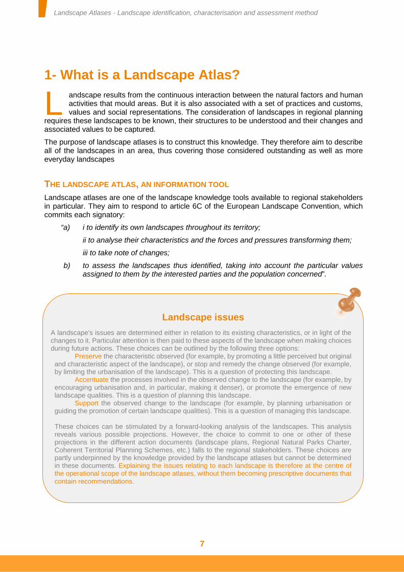
Landscape issues
A landscape's issues are determined either in relation to its existing characteristics, or in light of the changes to it. Particular attention is then paid to these aspects of the landscape when making choices during future actions. These choices can be outlined by the following three options:
Preserve the characteristic observed (for example, by promoting a little perceived but original and characteristic aspect of the landscape), or stop and remedy the change observed (for example, by limiting the urbanisation of the landscape). This is a question of protecting this landscape.
Accentuate the processes involved in the observed change to the landscape (for example, by encouraging urbanisation and, in particular, making it denser), or promote the emergence of new landscape qualities. This is a question of planning this landscape.
Support the observed change to the landscape (for example, by planning urbanisation or guiding the promotion of certain landscape qualities). This is a question of managing this landscape.
These choices can be stimulated by a forward-looking analysis of the landscapes. This analysis reveals various possible projections. However, the choice to commit to one or other of these projections in the different action documents (landscape plans, Regional Natural Parks Charter, Coherent Territorial Planning Schemes, etc.) falls to the regional stakeholders. These choices are partly underpinned by the knowledge provided by the landscape atlases but cannot be determined in these documents. Explaining the issues relating to each landscape is therefore at the centre of the operational scope of the landscape atlases, without them becoming prescriptive documents that contain recommendations.
Landscape Atlases - Landscape identification, characterisation and assessment method
8
In compliance with the European Landscape Convention, knowledge of a territory's landscapes is organised around three actions, each interdependent on the other two: identification*, description* and assessment*.
In addition, French Law No. 93-24 of 8 January 1993 on the protection and enhancement of landscapes introduces three concepts of use to considering landscapes in regional planning and development: landscape units*, landscape structures* and landscape elements*. The knowledge of landscapes contained in the landscape atlases is therefore underpinned by these three concepts.
The landscape information contained in the landscape atlases can only benefit a regional project if it is well-argued and shared between the stakeholders involved in the planning of this region or the future of its landscapes. Landscape atlases are therefore aimed at the different regional stakeholders, both public and private, and must be drawn up with their support.
Any confrontation between a landscape's characteristics, processes and social representations allows its issues to be identified. Landscape atlases therefore provide reliable and tried and tested knowledge to identify these landscape issues*.
The aim of a landscape atlas is to identify, characterise and assess all of the landscapes within its study area. It reports on the uniqueness of each landscape, the way in which this landscape is perceived and has been shaped and the manner in which it is changing. To this end, the landscape atlas relies on the concepts of landscape unit, landscape structure and landscape element. It provides a shared knowledge base for these landscapes and, finally, allows the major landscape issues to be determined.
WHAT LANDSCAPE ATLASES ARE NOT
A landscape atlas is a knowledge document. Like all knowledge, it participates in raising the awareness of the public and stakeholders in the regions. And because landscape atlases emphasise landscape issues, the knowledge produced is a call to action. However, landscape atlases do not contain any recommendations.
Every stakeholder involved in regional planning and development must be able to take landscapes into consideration and participate in their protection, management or planning. The choice of actions to be undertaken, the objectives they aim to achieve and the methods of implementing them remain the responsibility of the landscapes' different stakeholders in accordance with their respective competences.
WHO IS A LANDSCAPE ATLAS FOR? FOR WHAT PURPOSE?
The landscape knowledge acquired during the creation or update of a landscape atlas has a primarily operational purpose. It guides the choices of the regions' stakeholders. This landscape knowledge is testament in particular to the public's value* systems and their landscape representations. It therefore allows various conflicts relating to territorial planning and these people's surroundings to be avoided.
Finally, still without being the main tool, the landscape knowledge provided by landscape atlases also contributes to constructing a regional policy. It is used to summarise the link between the different factors involved in the transformation of these regions. It provides an overview of them.
Landscape Atlases - Landscape identification, characterisation and assessment method
9
A LANDSCAPE ATLAS TO GUIDE PUBLIC ACTION
Because landscape is common heritage*, it must be taken into account in public action. More still, it is essential to offer the public quality surroundings. The decisions made and strategies encouraged by the public authorities cannot rely on arbitrary information. On the contrary, they are underpinned by tried and tested knowledge.
Landscape atlases provide a well-argued knowledge base for landscape policies. In particular, they are used as a starting point for defining landscape quality objectives*. These aim to direct public decisions in regional planning matters in compliance with French Law. No. 2014-336 of 24 March 2014 on access to housing and town planning reform (ALUR law), expressed in article L. 122-1-3 and onwards of the French urban planning code.
A LANDSCAPE ATLAS TO RAISE AWARENESS AMONG REGIONAL STAKEHOLDERS
Testimonial “The Vosges Landscape Atlas was initially published on DVD Rom. This choice facilitated its distribution and appropriation (targeted reading, summaries and downloadable visuals). Furthermore, its interactive modules aimed at all audiences contributed to making it a genuine teaching resource. This atlas is also a reference document for our landscape policy. Employed to determine approaches to landscape plans and afforestation regulations and opinions on urban planning documents and used to illustrate slide shows during discussion or training days aimed at elected representatives and technicians, they have also served the partnerships conducted with the State, the French National Forests Office, the urban planning departments, etc. on subjects such as wind power, forestry and public spaces. Finally, the landscape atlas is widely used by the research offices working in the "département" and therefore contributes to creating a common culture of the characteristics of the Vosges landscapes.”
General Council of the Vosges, Department for Community Support and the Environment
Testimonial “This document is intended as a contribution to a sensitive landscape reading and is an initial response to the objective of the protection, management and planning of landscapes set by the Convention. It should in particular be used to initiate the discussion necessary to establishing urban planning documents whilst respecting, safeguarding and enhancing the landscape identity of Val-d'Oise.”
Pierre-Henry MACCIONI, Prefect of Val-d'Oise
(Landscape Atlas of Val-d’Oise, 2010).

Landscape Atlases - Landscape identification, characterisation and assessment method
10
Regional planning results from a set of actions. Each of these actions is liable to influence the future of landscapes. These actions are more often than not implemented by public or private stakeholders engaged in various sectoral activities. According to the characteristics of the region concerned, the landscape stakeholders may be farmers, foresters, planners, representatives of the economic world, artists, tourists and tourism professionals and so on. For many of these stakeholders, landscape is not at the heart of their profession or activity.
One of the objectives of the landscape atlases is therefore to involve these stakeholders in establishing the knowledge of the landscapes they shape or contribute to shaping. This participation, associated with the promotion of landscape knowledge, contributes to establishing a shared landscape knowledge base. This therefore encourages both the understanding of each stakeholder's role in the future of these landscapes and the consideration of these landscapes in conducting various regional activities.
A LANDSCAPE ATLAS TO CAPITALISE ON REUSABLE KNOWLEDGE
Numerous studies and analyses relating to landscapes are conducted each year: impact studies, preliminary studies for Coherent Territorial Planning Schemes (SCoT) and Local Development Plans (PLU), and so on. During each of these studies, a variety of information is gathered in relation to the landscapes. Yet the cost of this data collection is often considerable.
Landscape atlases can make a collection of reusable information available to the operators undertaking these studies. This provision reduces the cost of these studies. Nonetheless, this information must more often than not be complemented and updated to meet the specific objectives of the study undertaken.
A LANDSCAPE ATLAS TO PROMOTE PUBLIC PARTICIPATION
The future of landscapes concerns everyone. People may live or work in the region studied; they may also visit it or have an even more distanced relationship with it. When landscapes are
One landscape atlas, one process
The creation or update of a landscape atlas is above all an approach over time, involving different stakeholders. It is a continuous process for two reasons:
The first is linked to the involvement of the different stakeholders engaged in the production of landscape knowledge. Landscapes are linked to the public's representations of the region. At the same time, explaining the knowledge of the landscapes changes these representations. A landscape atlas is therefore not unlike the search for a dynamic balance between the public's representations and the consequences for the public of explaining these representations.
The second deals with the needs of the region's stakeholders. These stakeholders access and capture the landscape knowledge in different ways. The landscape atlases must therefore meet these different requirements. Thus the forms of exploiting the knowledge produced also appear to be constantly changing. A landscape atlas therefore appears less as a definitive work, whose style and content is established once and for all, as a process that leads to the production of a knowledge base shared and exploited in different ways.
Landscape Atlases - Landscape identification, characterisation and assessment method
11
representative of common heritage, the involvement of all of these people in the management, planning or protection of landscapes is legitimate.
Landscape consultations and participative management methods require shared knowledge. It is this principle of access to information that prevailed in the writing of the Aarhus Convention, ratified by France in 2002. The provision of the information contained in a landscape atlas and, to an even greater extent, the public participation in creating this landscape atlas are therefore evidence of the democratic management of landscapes and surroundings.
WHY UPDATE A LANDSCAPE ATLAS EVERY 10 YEARS?
The need to update landscape atlases is primarily linked to the changing nature of landscapes. Change is effectively one of the characteristics of landscapes and those that do not change are undoubtedly very rare, if they exist at all. The capture and reporting of landscape processes* are important aspects of a landscape atlas. The main landscape evolution mechanisms are noted in accordance with the rhythm of the landscape evolution*. This is the main purpose of updating a landscape atlas.
The various experience feedback analysed agrees on the fact that landscapes notably change over the course of a decade. The update of the knowledge contained in a landscape atlas therefore follows this average rhythm. This update concerns the description, assessment and identification of the landscape units (see chapter 3 – Creating or updating a landscape atlas). In effect, landscape structures and landscape elements are liable to transform both in their organisation and spatial distribution. Likewise, the social representations and value systems associated with the landscapes can vary. Finally, the boundaries of landscape units can also be modified (modification of the location or width of the boundaries, disappearance or appearance of new landscape units, radical transformations to landscape units, etc.)
In addition, twenty years after the initiation of the landscape atlas approach, both French and European landscape policy frameworks have changed. The different stakeholders are confronted with new demands. New knowledge relating to landscapes is therefore necessary to meet them.
Furthermore, methodological progress and technological advances also encourage a landscape atlas to be updated. The development of digital communication media and local information management and exchange tools, the dissemination of geolocation tools and so on, are creating new possibilities for investigation, analysis and diffusion. These new opportunities make it easier to raise awareness among all of the stakeholders and share data for the execution of subsequent studies. These aspects also encourage landscape atlases to be updated.
Finally, updating a landscape atlas also appears to be an opportunity to tackle the heterogeneity of the landscape atlases already published. This increase in consistency facilitates the sharing of information and experiences between regions dealing with similar landscape issues. It makes it possible to quickly summarise the information contained in several landscape atlases to answer common questions: problems relating to landscapes common to all coastal areas, management of peri-urban landscapes for medium sized French cities and so on…
Landscape Atlases - Landscape identification, characterisation and assessment method
12
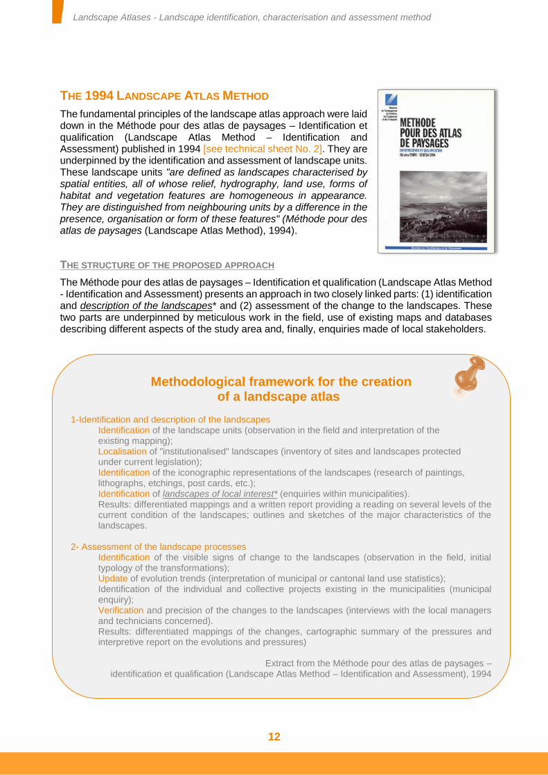
THE 1994 LANDSCAPE ATLAS METHOD
The fundamental principles of the landscape atlas approach were laid down in the Méthode pour des atlas de paysages – Identification et qualification (Landscape Atlas Method – Identification and Assessment) published in 1994 [see technical sheet No. 2]. They are underpinned by the identification and assessment of landscape units. These landscape units "are defined as landscapes characterised by spatial entities, all of whose relief, hydrography, land use, forms of habitat and vegetation features are homogeneous in appearance. They are distinguished from neighbouring units by a difference in the presence, organisation or form of these features" (Méthode pour des atlas de paysages (Landscape Atlas Method), 1994).
THE STRUCTURE OF THE PROPOSED APPROACH
The Méthode pour des atlas de paysages – Identification et qualification (Landscape Atlas Method - Identification and Assessment) presents an approach in two closely linked parts: (1) identification and description of the landscapes* and (2) assessment of the change to the landscapes. These two parts are underpinned by meticulous work in the field, use of existing maps and databases describing different aspects of the study area and, finally, enquiries made of local stakeholders.
Methodological framework for the creation of a landscape atlas
1-Identification and description of the landscapes
Identification of the landscape units (observation in the field and interpretation of the existing mapping); Localisation of "institutionalised" landscapes (inventory of sites and landscapes protected under current legislation); Identification of the iconographic representations of the landscapes (research of paintings, lithographs, etchings, post cards, etc.); Identification of landscapes of local interest* (enquiries within municipalities). Results: differentiated mappings and a written report providing a reading on several levels of the current condition of the landscapes; outlines and sketches of the major characteristics of the landscapes.
2- Assessment of the landscape processes
Identification of the visible signs of change to the landscapes (observation in the field, initial typology of the transformations); Update of evolution trends (interpretation of municipal or cantonal land use statistics); Identification of the individual and collective projects existing in the municipalities (municipal enquiry); Verification and precision of the changes to the landscapes (interviews with the local managers and technicians concerned). Results: differentiated mappings of the changes, cartographic summary of the pressures and interpretive report on the evolutions and pressures)
Extract from the Méthode pour des atlas de paysages –
identification et qualification (Landscape Atlas Method – Identification and Assessment), 1994
Landscape Atlases - Landscape identification, characterisation and assessment method
13
FEEDBACK ON TWENTY YEARS OF EXPERIENCE OF LANDSCAPE ATLASES
Review...
L’innovation The innovation of identifying and assessing all of a territory's landscapes has gradually become a necessity. The interest of having a description of the entirety of a territory's landscape units is now acknowledged. Landscape atlases are therefore knowledge documents appreciated by the main stakeholders in the territories.
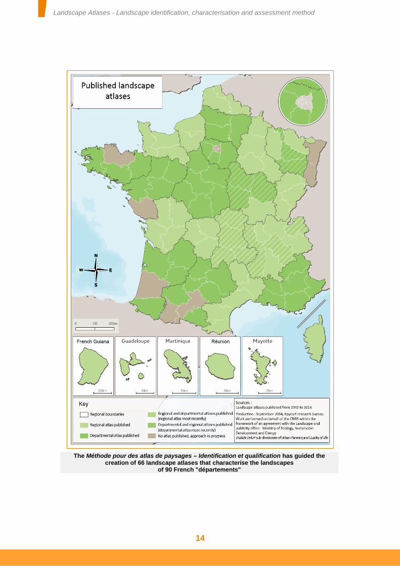
Today, 66 landscape atlases covering French "départements" and regions have been published. The landscape knowledge contained in these landscape atlases covers 93% of the surface area of the French territory. The creation of these landscape atlases is based on the Méthode pour des atlas de paysages – Identification et qualification (Landscape Atlas Method – Identification and Assessment) of 1994. The openness of this method has allowed different implementations according to the areas studied.
… and analyses
Regular meetings organised by the Sub-directorate of Urban Planning and Quality of Life at the ministry responsible for the environment have been used to gather a set of experience feedback relating to the creation and use of these landscape atlases. These meetings have taken the form of cross-border workshops (Conclusions des ateliers transfrontaliers sur les Atlas de paysages (Conclusions of Cross-Border Workshops on Landscape Atlases), 2009), cross-regional workshops (Conclusions des ateliers Inter-DIREN (Conclusions of Inter-DIREN Workshops), 2009) and thematic days (Conclusions et comptes-rendus des journées d’échanges (Conclusions and Minutes of Discussion Days), 2011). Likewise, various analyses of the published landscape atlases have been conducted regularly (Méthode pour les Atlas de paysages - Enseignements méthodologiques de 10 ans de travaux (Landscape Atlas Method - Methodological teachings from 10 years of work), 2004; Eléments pour la réalisation et l'actualisation des Atlas de paysages (Details for the Creation and Update of Landscape Atlases), 2009; Quelle place pour les paysages urbains dans les Atlas de paysages en France ? (What Place for Urban Landscapes in Landscape Atlases in France?), 2009).
All of this work and these analyses reveal a number of successes in steering landscape atlases. But they also emphasise several difficulties in the creation or use of these atlases. They also reveal a certain number of disparities between landscape atlases. These analyses therefore emphasise a few points that should arouse the attention of anyone involved in creating or updating a landscape atlas.
These analyses have been taken into consideration and enriched by the experience of the members of the steering committee for the work reported herein. Composed of 34 people, this steering committee brought together a variety of landscape atlas stakeholders: contracting authorities, project managers, civil service landscape architects and scientists. It met eight times in 2013 and 2014.
Landscape Atlases - Landscape identification, characterisation and assessment method
14
The Méthode pour des atlas de paysages – Identification et qualification has guided the creation of 66 landscape atlases that characterise the landscapes
of 90 French "départements"
Landscape Atlases - Landscape identification, characterisation and assessment method
15
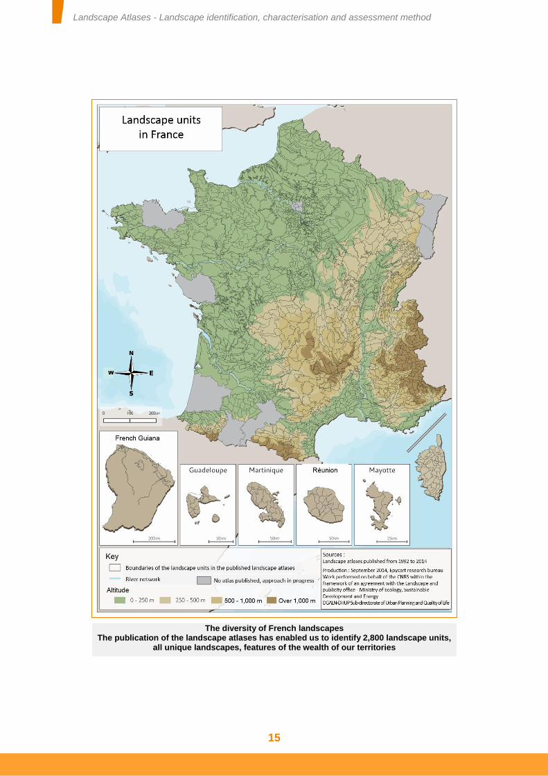
The diversity of French landscapes The publication of the landscape atlases has enabled us to identify 2,800 landscape units,
all unique landscapes, features of the wealth of our territories
Landscape Atlases - Landscape identification, characterisation and assessment method
16
SPECIFYING THE CONTEXT AND THE CHOICES MADE
The context in which the landscape knowledge approach was initiated and conducted must be presented. What were the main objectives? What reasons presided over the choices of available exploitation formats? Which stakeholders participated in this approach? These details are essential to ensuring the information provided is reliable, demonstrating its shared nature and establishing the scope for its possible uses.
HAVING A CONSISTENT LEVEL OF KNOWLEDGE BETWEEN THE LANDSCAPE ATLASES
Likewise, the accuracy of the work undertaken must be similar for each landscape atlas. Their operational scope requires clear texts. Furthermore, the work to identify landscape units is not necessarily similar for neighbouring landscape atlases. Disparities in the accuracy of the work conducted and the treatment of boundaries, in particular fuzzy boundaries marked by a transition zone between two landscape units, sometimes pose a few problems.
On the strength of this experience, it is possible to emphasise four aspects of landscapes that require particular attention within the framework of creating or updating a landscape atlas:
The landscape processes must be specified: the landscape evolution is described and the mechanisms responsible for this evolution identified,
Work on the social representations of the landscapes and the associated value systems must be continued and strengthened. Some landscape atlases analyse the way in which the landscapes are artistically or academically represented. However, the capture and analysis of the local people's representations of each landscape unit deserve special attention and a sustained effort. These local social representations are used to specify the landscape issues that can then be considered by the landscape and regional stakeholders,
Testimonial “The term "landscape" applies to many environments. It is very restrictive to want to limit it to all that concerns nature, for which the term is most often reserved. Landscape is the area encompassed in a single view. It is irrelevant whether the image perceived represents nature, plants, minerals, a built environment or a set of features. Thus urban areas are a landscape in their own right in so far as their contents and settings are perceived in the same way as a natural landscape, with the influence they exert on the senses of the person perceiving them. A street and its architectural setting, like a majestic avenue of trees in parkland or a forest, are landscape elements. However, urban areas, which are landscapes in their own right, must be distinguished from built structures, urban clusters and urban profiles that form an integral part of a larger landscape”
(Inventory of the Landscapes of Aisne, 2004).
Landscape Atlases - Landscape identification, characterisation and assessment method
17
Landscape structures must be described and located. It is these that form the basis of numerous landscape policies and allow the landscape to be considered in regional planning actions. The latest landscape atlases published and the increasingly frequent use of block diagrams offer interesting examples of ways in which these landscape structures can be analysed and reported,
Finally, urban landscapes must be accurately reported given their importance to the surroundings of numerous populations.
REPORTING THE INFORMATION AND MAKING IT AVAILABLE
The formats in which the information is reported must allow the knowledge contained in the landscape atlases to be used to protect, manage and plan landscapes or to take them into consideration in regional development. These reporting formats must therefore meet the requirements of the landscape and regional stakeholders.
Illustrations, figures and graphic representations must always be captioned. In particular, the production of maps, sketches and block diagrams is encouraged and preferably standardised [see technical sheet No. 6].
Furthermore, the availability of the information and freedom of use deserve careful consideration. The availability of the landscape atlases must be guaranteed. The graphic quality must enable them to be used effectively. Likewise, the usage conditions of all or some of the information presented in a landscape atlas should not be limited.
These aspects ensure the information produced within the framework of the landscape atlases is reused. They encourage the landscape to be taken into consideration in public policies and private projects.
Urban area landscapes
In 2010, 77.5% of the French population lived in urban areas. Cities occupy almost 22% of the surface area of mainland France, a notable increase from 19% ten years ago. These areas therefore represent the living surroundings of the majority of the French. In spite of this, urban areas are little, poorly or not at all analysed in a number of landscape knowledge documents and landscape atlases in particular (Quelle place pour les paysages urbains dans les Atlas de paysages en France ? (What Place for Urban Landscapes in Landscape Atlases in France?) 2009). This state of affairs applies even more to the areas on the urban fringes, whose landscape processes are significant and concentrate considerable stakes for sustainable development. The existence of urban landscapes is effectively still a subject of discussion. This is probably linked to two phenomena: on the one hand the restrictive view held of landscape, strongly associated with a culture of nature and, on the other hand, the idea that urban areas could not be perceived in their entirety. The idea of landscape proposed by the European Landscape Convention does not restrict landscapes to spaces deemed to be natural but extends them to all areas. The appraisal and consideration of landscapes therefore concern urban and urbanised areas just as much as any other. Developing this knowledge of landscapes in urban areas contributes to raising stakeholders' awareness of the reality and interest of these landscapes in the future of the surroundings of increasingly large populations.
Landscape Atlases - Landscape identification, characterisation and assessment method
18
This document builds on the Méthode pour des Atlas de paysages – identification et qualification (Landscape Atlas Method – Identification and Assessment) of 1994. It proposes new perspectives by offering some precisions and discussing different aspects which, due to technical or regulatory developments since, were not on the agenda at the time.
Herein we will discuss the different principles that structure the creation or update of a landscape atlas.
Certain points specific to the updating of a landscape atlas are presented in bold type and highlighted in blue.
Landscape Atlases - Landscape identification, characterisation and assessment method
19
2- Organisation for producing a landscape atlas
he approach adopted to create or update a landscape atlas mobilises various stakeholders in the landscape and regions covered by the study area. They must all participate to construct a shared knowledge of landscapes. This shared nature is essential
to the consideration of landscapes in regional planning and the construction of quality surroundings.
ORGANISING AND DISTRIBUTING ROLES BETWEEN THE PARTNERS
The organisation of the stakeholders involved in creating or updating a landscape atlas follows two principles. On the one hand, it must strengthen and support the rigour of the approach adopted. On the other hand, it must promote the sharing of knowledge. This sharing as much concerns the knowledge produced during the approach adopted as the knowledge that pre-existed this approach (previous landscape atlases, landscape representations, studies and documents covering all or part of the study area, etc.).
The creation or update of a landscape atlas relies on the usual dialogue between the contracting authority and project manager. However, the construction and sharing of landscape knowledge requires other stakeholders to participate. The creation or update of a landscape atlas therefore relies on a steering committee. The contracting authority can be helped by an assistant and a monitoring committee. Finally, the establishment of a coordination committee must be considered. The efficacy of each of these stakeholders and the organisation they form depends on each of their roles being accurately defined.
T
Testimonial “Everyone has their own idea of landscape. It was therefore necessary to construct a "shared view" of the quality of the area, which allows us to arrive at a collective recognition of our landscapes. This knowledge helps us to act and avoid the often exaggerated blockages and confrontations between "protectors" and "developers". This is the objective of the atlas we have designed with the help of partners brought together in a steering committee. We are happy to make it available to all of the stakeholders in the areas, regional authorities and civil society, to support them in their projects. Projects that will be all the more sustainable as they take care to preserve and enrich our landscapes at the highest level.”
Pascal MAILHOS Prefect of the Côte d'Or
Landscape Atlas of the "département" of the Côte-d'Or, 20110
Landscape Atlases - Landscape identification, characterisation and assessment method
20
CONTRACTING AUTHORITY
Although the creation of a landscape atlas forms part of the policies of the ministry responsible for the environment, its implementation must be a partnership between the State and regional authorities (in the regions and "départements" especially).
The role of the contracting authority is:
To set the objectives for the creation and update of the landscape atlas,
To define the requirements of the landscape atlas and the media on which it is exploited. These points are stated in the specifications,
To monitor the work undertaken throughout the creation or update of the landscape atlas. This monitoring is supported by intermediate validations at each step of the process,
To validate the work at the end of the study. This validation is expressed in the "editorial" that introduces the landscape atlas. This aspect is fundamental as it attests to the fact that the knowledge produced by the landscape atlas indeed takes account of the regional issues and stakeholders engaged in this approach. The landscape atlas therefore indeed provides a shared knowledge base.
PROJECT MANAGEMENT
The project management of a landscape atlas largely relies on landscape specialists (landscape architects, landscape engineers, geographers, etc.). Their role is fundamental. However, to identify, characterise and assess a landscape, several aspects must be covered, requiring several competences to be involved.
Thus, although project management is often awarded to a landscape specialist, he must enlist other competences: geology, sociology, urban planning, ecology and so on. According to the study area, when writing the specifications it may be desirable to state the fact that some competences must absolutely be represented in the team tasked with project management: capture of social representations, ecological analysis, etc. The landscape specialist brings his cross-disciplinary skills. He also plays the role of coordinator or mediator between the various competences involved, so as to provide an understanding of the complexity of the landscapes arising from the interactions between the landscape's characteristics, its processes and its social representations.
Furthermore, it may be important to enlist teams that specialise in the landscape atlas exploitation formats: constructing decision-making support materials (databases, geographical information systems, etc.), constructing websites or publishing documents. These aspects are linked to the nature and format of the materials for exploiting the landscape atlas selected by the contracting authority. They depend on the functions assigned to the landscape atlas. These aspects must be stated in the specifications.
Landscape Atlases - Landscape identification, characterisation and assessment method
21
STEERING COMMITTEE
The steering committee plays a pivotal role in creating or updating a landscape atlas. It takes part in the discussions between the contracting authority and project management.
Steering committee composition
The steering committee is composed of the different partners involved in regional development and the management, protection and planning of landscapes. It therefore brings together elected representatives, the civil service landscape architect, representatives of the State's decentralised departments, the regional council, general council, urban planning departments (CAUE), municipalities and intercommunalities, interested associations and qualified individuals as well as representatives of local chambers. Its composition is adapted to the study area, but several points are important:
The voluntary nature of the commitment of interested associations and qualified individuals must be taken into account.
Mayors, chairs of public intermunicipal cooperation establishments and managers of structures that participate in Coherent Territorial Planning Schemes (SCoT) must be encouraged to take part. These stakeholders can, in particular, participate in discussions concerning the requirements of the landscape atlas.
Likewise, the participation of professional stakeholders for whom the landscape is not their core profession but who are involved in business sectors that have an influence on its future should also be encouraged. Thus according to the characteristics of the study area, farming representatives, representatives of tourism professionals and the main developers among others should be part of the steering committee.
The composition of the steering committee can be widened for specific operations (workshops, seminars, etc.).
To guide the steering committee's discussions, all of its members should become acquainted with this landscape atlas method.
Role of the steering committee: the committee has two other functions
To monitor and advise the project manager and contracting authority:
It contributes to establishing the objectives of the landscape atlas. It is involved far upstream of the start of work by the landscape atlas's project manager. It advises the contracting authority on the definition of the specifications, the consideration of the regional issues and the requirements of the areas' stakeholders
When updating a landscape atlas, the steering committee can issue recommendations relating to the implementation of this method in order to add to the existing landscape atlas.
It monitors every phase of the study defined by the specifications: identification and description of the landscape units, illustration of the social representations of the landscapes, analysis of the landscape processes, identification of the landscape's issues and exploitation and distribution of the landscape atlas. It assesses the intermediate results, advising the contracting authority. Likewise, it advises the project management as much as possible.
Landscape Atlases - Landscape identification, characterisation and assessment method
22
To be a source of information:
The members of the steering committee gather documents that will be of use to the project manager.
The steering committee can, for certain objectives (capturing social representations), represent all of the local landscape stakeholders.
Steering committee organisation
The steering committee meets in the key phases of the study's execution. For information, it is desirable to indicate the planned number of meetings (3 to 4 times per year). The stability and commitment of the members of this committee guarantee the quality and utility of the landscape atlas produced. The steering committee can meet in the territory, changing the meeting place within the study area.
MONITORING COMMITTEE
The monitoring committee is the technical body representing the project management in the regular monitoring of the approach adopted to create or update the landscape atlas. With a smaller membership than the steering committee, it must be easy to mobilise and meets more often (it can meet between 6 and 8 times a year). Its role is essentially technical: ensuring the approach adopted runs smoothly.
COORDINATION COMMITTEE
The establishment of a coordination committee is desirable to support the exploitation of the knowledge in the landscape atlas, especially over the long term and after the study phase. This group, smaller than the steering committee, is characterised by its technical competences. It brings together stakeholders involved in the protection, management and planning of landscapes. It can also involve the structures that participate in Coherent Territorial Planning Schemes (SCoT) and the associations that take part in the Departmental Commission for Nature, Landscapes and Sites. The constitution of this coordination committee can be based on the circular memo relating to the promotion and implementation of the European Landscape Convention, dated 1 March 2007, which requires a "département's" landscape stakeholders to meet regularly.
The role of this coordination committee is to promote the content of the landscape atlas, encourage its use and prepare its update. It is this committee that brings the landscape atlas "to life".
PREPARING FOR THE CREATION OR UPDATE OF A LANDSCAPE ATLAS
The approach adopted to create or update a landscape atlas requires a certain amount of preparation. This step is an opportunity to specify the technical provisions of the public contract on which the approach is built. It is during this preparatory step that the objectives to be attained are defined and the conditions necessary for this work to be undertaken are specified.
Landscape Atlases - Landscape identification, characterisation and assessment method
23
THE SHARING OF OBJECTIVES
A landscape atlas provides a shared landscape knowledge base. This sharing is underpinned by several factors. Participation in establishing or updating the landscape atlas is one very effective factor. The free availability of the knowledge acquired during this approach is another. But this knowledge sharing relies, above all, on all of the stakeholders concerned appropriating the approach and the documents produced.
This appropriation is facilitated by the steering committee's involvement in preparing the specifications. Several points can be considered:
Good knowledge of the areas enables the members of the steering committee to understand, even if only vaguely, different aspects of the landscapes and forces that cross them. Particular attention must be paid to these aspects within the framework of the adopted approach.
The steering committee brings together the representatives of the stakeholders who will use the details arising from the landscape atlas (urban planning agencies, structures participating in Coherent Territorial Planning Schemes (SCoT) and so on). Its members therefore have important opinions on the aspects to be considered if the landscape atlas and the information it contains are to be used effectively.
The members of the steering committee hold or know of various documents or information that will be of use to the project manager.
Finally, steering committee members involved in the regional planning bodies that make up the study area will be able to explain certain local policy objectives that will complement the objectives of the contracting authority.
The mobilisation of the steering committee to define the objectives of the landscape atlas requires several working sessions spread over 6 to 12 months. The work to coordinate this can be entrusted to a contracting authority assistant.
The first session is devoted to presenting the landscape atlas approach. This is a question of presenting the foundations of the landscape knowledge, the objectives and the general organisation of the approach.
The following sessions can be devoted to:
Appropriation and analysis of the existing landscape atlases for the study area or neighbouring regions. This enables the requirements of the work undertaken to be specified. This analysis is complemented by the experience feedback from other studies and work concerning the landscapes in the study area.
The understanding, availability and use of these documents, to which particular attention is paid. This is a question of defining the conditions necessary to the effective use of the information produced, on the one hand for the management, protection and planning of landscapes and, on the other hand, for the consideration of landscapes in regional planning and more sectoral operations (availability of the information and formats of this information).
When updating a landscape atlas, this attention can be focussed on the experience feedback on the uses of the previous version. In what scenarios was it used? Which properties of the landscape atlas promoted or limited these uses?
Landscape Atlases - Landscape identification, characterisation and assessment method
24
The constitution of reference documentation. This is an opportunity to pool resources and hold discussions between the steering committee members so that they all share equal knowledge of this "inventory". A bibliography of these documents is drawn up and will be completed by the project manager.
The identification of the different resources available to conduct the study. These resources concern in particular certain landscape data acquired either within the framework of a previous landscape atlas, or as part of past studies concerning the protection, management and planning of landscapes, regions and the environment 1. They also concern the landscape processes. Some of this data is relatively difficult to acquire and its availability to the project manager facilitates his work.
The identification of the main challenges of creating or updating the landscape atlas.
Thus although the specifications for the landscape atlas are drafted under the responsibility of the contracting authority, the steering committee advises the author.
FORMALISATION OF THE SPECIFICATIONS
The specifications explain the objectives pursued. They specify in particular the format required for reporting the work so that the candidates can effectively put together the team they will propose. The specifications must also indicate the existing knowledge, whether it be from landscape atlases already created or resources made available to the project manager (steering committee composition, available data and information, etc.).
For budgetary reasons, it is recommended the required work be divided into several mandatory packages that follow the budget years. However, the objectives of each of these phases are specified to ensure the approach is consistent. The financial envelopes are communicated in the specifications so that the candidates can adapt the mobilisation of their resources to the means available.
Finally, it is important that the contracting authority has the capacity to assess the necessary workload to meet each of these requirements. The feasibility of the requirements and proposals will then be able to be assessed in light of the financial envelope set aside.
1 This is the case, for example, during the creation of a local development plan which, pursuant to article L 123-1-5 7 of the French urban planning code, is an opportunity to "identify and locate landscape elements […] and define, where applicable, the prescriptions liable to ensure their protection".
Landscape Atlases - Landscape identification, characterisation and assessment method
25
Details of Special Technical Specifications regarding the general objectives of the landscape atlases
It is advisable to present the background to the approach and state the requirements:
Presentation of the territory of the study area, its administrative organisation and its main development and planning issues. Presentations of the landscape atlas sponsors and steering committee. Explanation of the motivations behind the landscape atlas being created or updated. This could take account of the issues and regional processes identified in the territory (Coherent Territorial Planning Scheme (SCoT), Local Development Plan (PLU)(i), Regional Natural Parks Charter, etc.). Estimate of the total available financial envelope. Finally, according to the issues already identified in the territory, it may be helpful to specify essential subjects that must be covered by the landscape atlas (landscape processes, exploitation formats, database construction, etc.). When updating a landscape atlas, these subjects may relate to the landscape units, structures or elements to which particular attention should be paid.
It is also advisable to identify the internal skills and available resources and to define the expectations of the service provider. The Special Technical Specifications may therefore:
Detail the intentions of the governance and coordination of the approach adopted. Specify any working groups or workshops planned, the composition of the steering committee and technical committee, the number of meetings and so on. List the available resources: documents (existing landscape atlases covering the study area and adjacent areas, databases, photographic observatories, etc.) and people (steering committee, monitoring committee, human resources, etc.). Detail the general tasks assigned to the service provider:
Landscape description of the study area
Identification, assessment and description of the landscape units
Explanation of the landscape structures in each landscape unit
Construction of a database of the landscape elements
Analysis of the social representations of the landscapes that are meaningful on the scale of the study area and on the scale of each landscape unit
Detail the specific tasks assigned to the service provider (and the skills or methodological evidence required to fulfil them). For example:
Capturing the social representations and value systems associated with the landscapes
Identifying, characterising and assessing urban landscapes
Exploiting the information produced in digital format
Constructing databases (technical features, etc.) Finally, it is advisable to explain the contracting authority's requirements relating to the result reporting format (summary document, databases, mapping, etc.) and the expected exploitation formats (paper publication or digital publication)
Duration of rights Accessibility to the illustrations and contents of the landscape atlas (minimum graphic and digital qualities) Format of databases relating to the landscapes. This format must enable this data to be reused in subsequent studies. The use of Geographical Information Systems is strongly encouraged.
Landscape Atlases - Landscape identification, characterisation and assessment method
26
To ensure there is sufficient financing for the landscape atlas and initiate close collaboration between the landscape stakeholders, close involvement and co-financing should be sought from the State's decentralised departments and regional authorities. Recourse to European funds is encouraged.
.
** Prices are inclusive of taxes
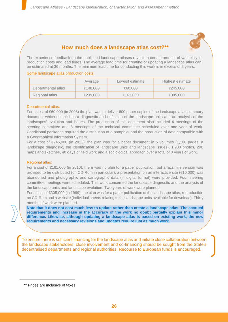
How much does a landscape atlas cost?**
The experience feedback on the published landscape atlases reveals a certain amount of variability in production costs and lead times. The average lead time for creating or updating a landscape atlas can be estimated at 36 months. The minimum lead time for conducting this work is in excess of 2 years.
Some landscape atlas production costs:
Average Lowest estimate Highest estimate
Departmental atlas €148,000 €60,000 €245,000
Regional atlas €239,000 €161,000 €305,000
Departmental atlas:
For a cost of €60,000 (in 2008) the plan was to deliver 600 paper copies of the landscape atlas summary
document which establishes a diagnostic and definition of the landscape units and an analysis of the
landscapes' evolution and issues. The production of this document also included 4 meetings of the
steering committee and 6 meetings of the technical committee scheduled over one year of work.
Conditional packages required the distribution of a pamphlet and the production of data compatible with
a Geographical Information System.
For a cost of €245,000 (in 2012), the plan was for a paper document in 5 volumes (1,100 pages: a
landscape diagnostic, the identification of landscape units and landscape issues), 1,900 photos, 290
maps and sketches, 40 days of field work and a sociological approach over a total of 3 years of work.
Regional atlas:
For a cost of €161,000 (in 2010), there was no plan for a paper publication, but a facsimile version was
provided to be distributed (on CD-Rom in particular), a presentation on an interactive site (€10,000) was
abandoned and photographic and cartographic data (in digital format) were provided. Four steering
committee meetings were scheduled. This work concerned the landscape diagnostic and the analysis of
the landscape units and landscape evolution. Two years of work were planned.
For a cost of €305,000 (in 1999), the plan was for a paper publication of the landscape atlas, reproduction
on CD-Rom and a website (individual sheets relating to the landscape units available for download). Thirty
months of work were planned.
Note that it does not cost much less to update rather than create a landscape atlas. The accrued requirements and increase in the accuracy of the work no doubt partially explain this minor difference. Likewise, although updating a landscape atlas is based on existing work, the new requirements and necessary revisions and updates require just as much work.
Landscape Atlases - Landscape identification, characterisation and assessment method
27
3- Creating or updating a landscape atlas
THE DIFFERENT SCALES TO CONSIDER
The landscape knowledge constructed within the framework of a landscape atlas is based on two types of scale: geographic scales and time scales.
GEOGRAPHIC SCALES
Departmental or regional atlas?
Landscape atlases are managed at an infraregional level of organisation. The "département" is the geographic level of organisation responsible for the majority of approaches adopted.
However, it is common for the approaches adopted in several "départements" in the same region to be conducted together. There are therefore two scenarios. Either there is one regional approach, or several departmental approaches coordinated at regional level. The continuity of landscape units between "départements" can be more easily perceived and reported in a regional landscape atlas because the landscape units are identified across the different departments in a coordinated manner. However, the differences observed between these two scenarios are not significant in terms of the quality of the knowledge produced.
The choice to use one or other strategy is therefore essentially guided by practical considerations on the part of the landscape atlas stakeholders and the contracting authorities in particular.
Furthermore, the landscape atlas approach could be applied to the area covered by a Coherent Territorial Planning Scheme (SCoT), Regional Natural Park (PNR) or major valleys... all areas shared between numerous populations.
Accuracy and geographic scales of a landscape atlas
The approach adopted must allow landscape knowledge to be constructed on the scale of 1/100,000. The accuracy of the analyses conducted in the field is 1/25,000, except in certain parts of the region, in particular urban areas, where the work can be conducted on a scale of 1/10,000 or even 1/5,000.
These scales determine the accuracy of the work undertaken in terms of data gathering, data analysis and the formalisation of the information produced. They determine the accuracy of the landscape elements selected and the landscape structures identified.
It is therefore important to respect these working scales. In effect, these define the scope for using the data and information contained in the landscape atlases for landscape studies or different regional planning or policy documents. If these documents or projects are on a scale greater than 1/25,000 (more accurate project), the available landscape knowledge in the landscape atlases must be clarified.
LANDSCAPE PROCESSES AND TIME SCALES
Article 6 of the European Convention, which guides knowledge of landscapes, enjoins the signatory parties “to analyse their characteristics and the forces and pressures transforming them [and] to note the changes”.
Landscape Atlases - Landscape identification, characterisation and assessment method
28
Work addressing the question of landscape evolution reveals that this often results from the interaction of several natural and human factors: erosion, the expansion of housing, change in values associated with perceived elements, comprehensive changes, agricultural changes, development of economic activity, natural catastrophe, significant landscaping projects, etc.
The interactions between a landscape's different evolution mechanisms are particularly perceptible in the changes to the modes of land use. However, landscape evolution is not based on these changes alone. It includes other components such as the modification of perceptions* and social representations*. Thus a landscape's evolution concerns both its material aspect (what is perceived, the appearance of the area) and its immaterial aspect (the values and representations associated with what is perceived).
Different landscape processes have their own time scales. Landscape atlases therefore include different time scales to report on landscape evolution and the different evolution mechanisms in these landscapes. It is not possible to impose a principle in advance. The time scales to be analysed are determined in accordance with the specific features of each study area and every landscape unit.
THE ORGANISATION OF LANDSCAPE KNOWLEDGE
The organisation of the knowledge is underpinned by three actions and three concepts:
Actions: identification, description and assessment.
Concepts: landscape unit, landscape structure and landscape elements.
Landscape evolution and evolution mechanisms
There is a certain amount of confusion between landscape evolution and factors that lead to this evolution that we propose to call evolution mechanisms. These two notions are neither described using the same sources of information, nor analysed using the same skills. Landscape evolution concerns the landscape in its entirety. It can be captured in the field, by comparing different portrayals (often photographic) of the landscape, or by identifying the visible signs of change. Landscape evolution reflects the synthesis of the effects of different evolution mechanisms which, themselves, are not necessarily perceptible in the landscape (increase in land prices, variation in temperatures, change in profitability of a particular activity, presence of invasive species, variation in the average age of the population or unemployment rate, etc.). The identification of these evolution mechanisms requires research of the different descriptors provided over time. Chronological inventories, lists and databases held by public and private stakeholders may provide such data. The analysis of these different lists therefore strengthens the creation or update of a landscape atlas. In particular, the use of these lists strengthens the landscape analyses and reveals the factual foundations of sensitive assessments of the landscapes.
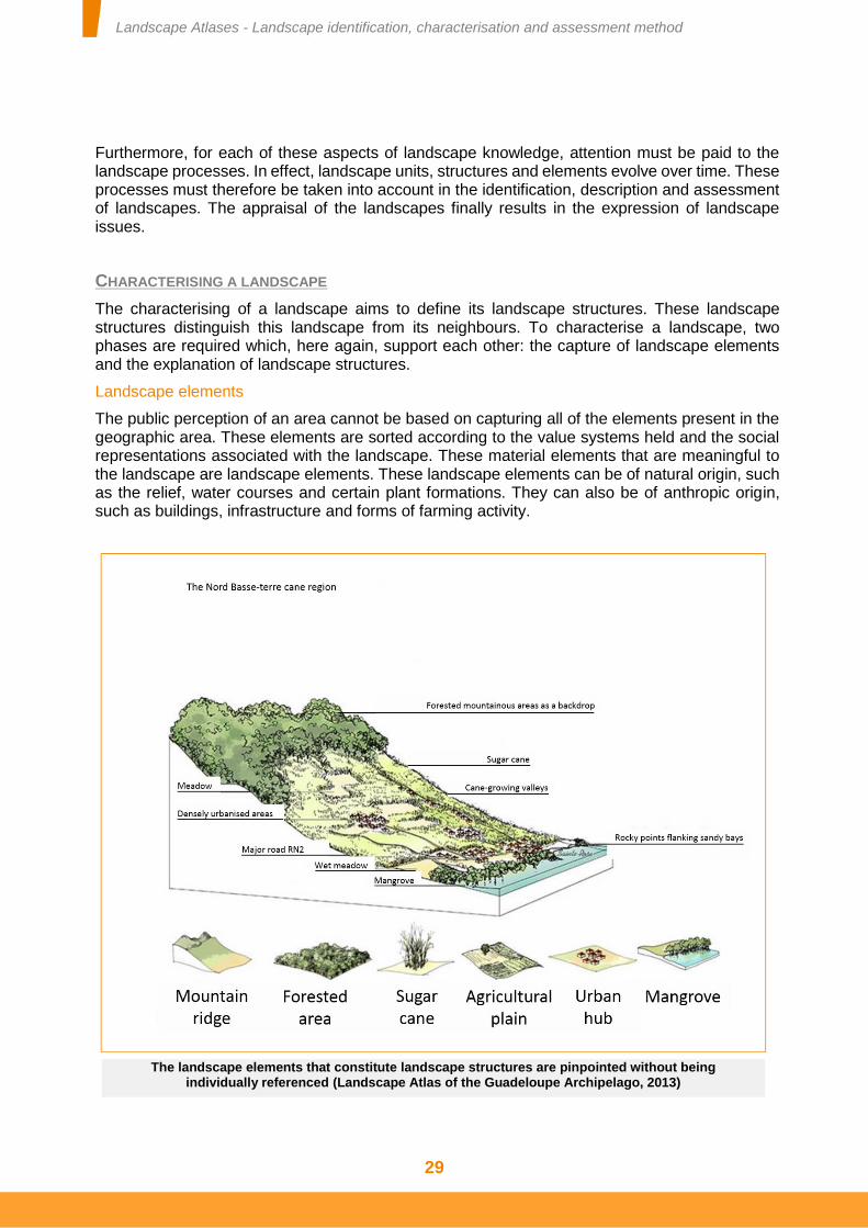
Landscape Atlases - Landscape identification, characterisation and assessment method
29
Furthermore, for each of these aspects of landscape knowledge, attention must be paid to the landscape processes. In effect, landscape units, structures and elements evolve over time. These processes must therefore be taken into account in the identification, description and assessment of landscapes. The appraisal of the landscapes finally results in the expression of landscape issues.
CHARACTERISING A LANDSCAPE
The characterising of a landscape aims to define its landscape structures. These landscape structures distinguish this landscape from its neighbours. To characterise a landscape, two phases are required which, here again, support each other: the capture of landscape elements and the explanation of landscape structures.
Landscape elements
The public perception of an area cannot be based on capturing all of the elements present in the geographic area. These elements are sorted according to the value systems held and the social representations associated with the landscape. These material elements that are meaningful to the landscape are landscape elements. These landscape elements can be of natural origin, such as the relief, water courses and certain plant formations. They can also be of anthropic origin, such as buildings, infrastructure and forms of farming activity.
The landscape elements that constitute landscape structures are pinpointed without being individually referenced (Landscape Atlas of the Guadeloupe Archipelago, 2013)
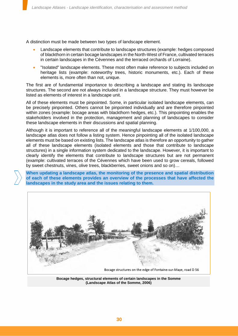
Landscape Atlases - Landscape identification, characterisation and assessment method
30
A distinction must be made between two types of landscape element.
Landscape elements that contribute to landscape structures (example: hedges composed of blackthorn in certain bocage landscapes in the North-West of France, cultivated terraces in certain landscapes in the Cévennes and the terraced orchards of Lorraine).
"Isolated" landscape elements. These most often make reference to subjects included on heritage lists (example: noteworthy trees, historic monuments, etc.). Each of these elements is, more often than not, unique.
The first are of fundamental importance to describing a landscape and stating its landscape structures. The second are not always included in a landscape structure. They must however be listed as elements of interest in a landscape unit.
All of these elements must be pinpointed. Some, in particular isolated landscape elements, can be precisely pinpointed. Others cannot be pinpointed individually and are therefore pinpointed within zones (example: bocage areas with blackthorn hedges, etc.). This pinpointing enables the stakeholders involved in the protection, management and planning of landscapes to consider these landscape elements in their discussions and spatial planning.
Although it is important to reference all of the meaningful landscape elements at 1/100,000, a landscape atlas does not follow a listing system. Hence pinpointing all of the isolated landscape elements must be based on existing lists. The landscape atlas is therefore an opportunity to gather all of these landscape elements (isolated elements and those that contribute to landscape structures) in a single information system dedicated to the landscape. However, it is important to clearly identify the elements that contribute to landscape structures but are not permanent (example: cultivated terraces of the Cévennes which have been used to grow cereals, followed by sweet chestnuts, vines, olive trees, blackberries, sweet onions and so on)…
When updating a landscape atlas, the monitoring of the presence and spatial distribution of each of these elements provides an overview of the processes that have affected the landscapes in the study area and the issues relating to them.
Bocage hedges, structural elements of certain landscapes in the Somme (Landscape Atlas of the Somme, 2006)
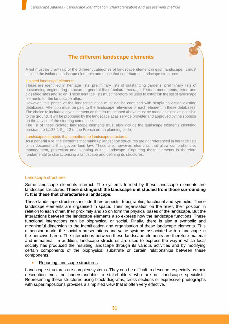
Landscape Atlases - Landscape identification, characterisation and assessment method
31
Landscape structures
Some landscape elements interact. The systems formed by these landscape elements are landscape structures. These distinguish the landscape unit studied from those surrounding it. It is these that characterise a landscape.
These landscape structures include three aspects: topographic, functional and symbolic. These landscape elements are organised in space. Their organisation on the relief, their position in relation to each other, their proximity and so on form the physical bases of the landscape. But the interactions between the landscape elements also express how the landscape functions. These functional interactions can be biophysical or social. Finally, there is also a symbolic and meaningful dimension to the identification and organisation of these landscape elements. This dimension marks the social representations and value systems associated with a landscape in the perceived area. The interactions between these landscape elements are therefore material and immaterial. In addition, landscape structures are used to express the way in which local society has produced the resulting landscape through its various activities and by modifying certain components of the biophysical substrate or certain relationships between these components.
Reporting landscape structures
Landscape structures are complex systems. They can be difficult to describe, especially as their description must be understandable to stakeholders who are not landscape specialists. Representing these structures using block diagrams, cross-sections or expressive photographs with superimpositions provides a simplified view that is often very effective.
The different landscape elements
A list must be drawn up of the different categories of landscape element in each landscape. It must include the isolated landscape elements and those that contribute to landscape structures.
Isolated landscape elements These are identified in heritage lists: preliminary lists of outstanding gardens, preliminary lists of outstanding engineering structures, general list of cultural heritage, historic monuments, listed and classified sites and so on. These heritage lists must therefore be used to establish the list of landscape elements for the landscape atlas. However, this phase of the landscape atlas must not be confused with simply collecting existing databases. Attention must be paid to the landscape relevance of each element in these databases. The choice to include a given element on the list mentioned above must be made as close as possible to the ground. It will be proposed by the landscape atlas service provider and approved by the sponsor on the advice of the steering committee. The list of these isolated landscape elements must also include the landscape elements identified pursuant to L.123-1-5_III-2 of the French urban planning code.
Landscape elements that contribute to landscape structures As a general rule, the elements that make up landscape structures are not referenced in heritage lists or in documents that govern land law. These are, however, elements that allow comprehensive management, protection and planning of the landscape. Capturing these elements is therefore fundamental to characterising a landscape and defining its structures.
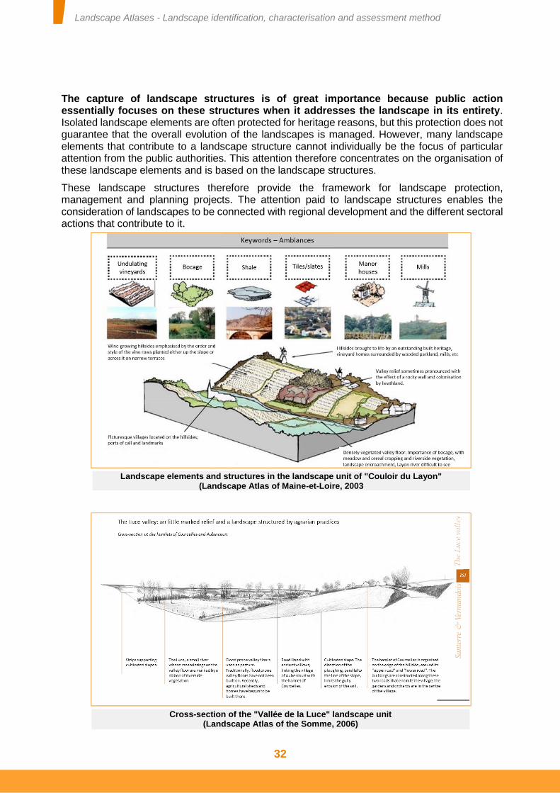
Landscape Atlases - Landscape identification, characterisation and assessment method
32
The capture of landscape structures is of great importance because public action essentially focuses on these structures when it addresses the landscape in its entirety. Isolated landscape elements are often protected for heritage reasons, but this protection does not guarantee that the overall evolution of the landscapes is managed. However, many landscape elements that contribute to a landscape structure cannot individually be the focus of particular attention from the public authorities. This attention therefore concentrates on the organisation of these landscape elements and is based on the landscape structures.
These landscape structures therefore provide the framework for landscape protection, management and planning projects. The attention paid to landscape structures enables the consideration of landscapes to be connected with regional development and the different sectoral actions that contribute to it.
Landscape elements and structures in the landscape unit of "Couloir du Layon" (Landscape Atlas of Maine-et-Loire, 2003
Cross-section of the "Vallée de la Luce" landscape unit (Landscape Atlas of the Somme, 2006)
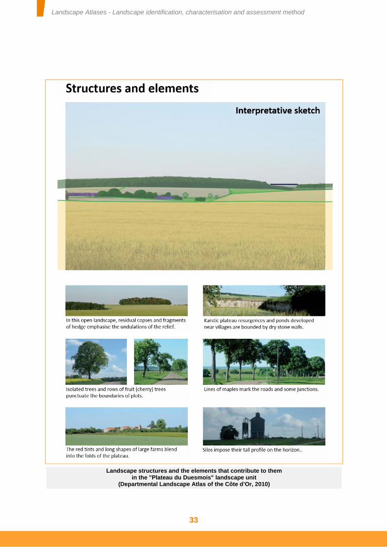
Landscape Atlases - Landscape identification, characterisation and assessment method
33
Landscape structures and the elements that contribute to them in the "Plateau du Duesmois" landscape unit
(Departmental Landscape Atlas of the Côte d’Or, 2010)
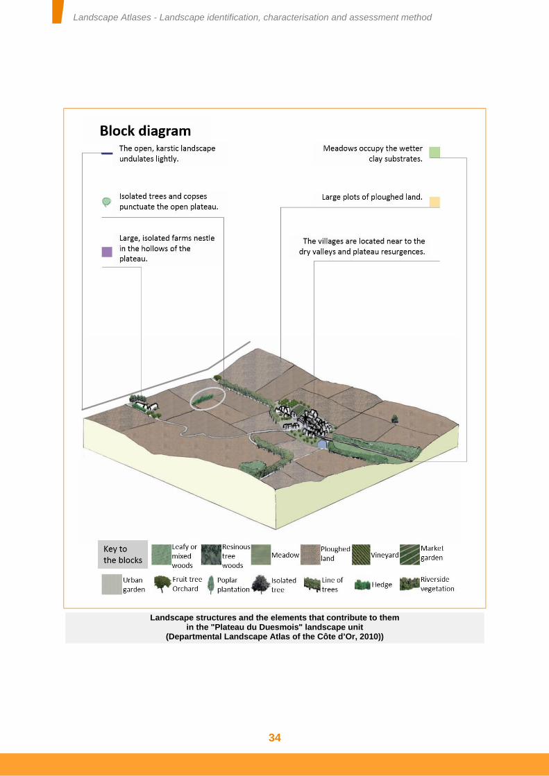
Landscape Atlases - Landscape identification, characterisation and assessment method
34
Landscape structures and the elements that contribute to them in the "Plateau du Duesmois" landscape unit
(Departmental Landscape Atlas of the Côte d’Or, 2010))
Landscape Atlases - Landscape identification, characterisation and assessment method
35
When updating a landscape atlas, it will be necessary to assess the landscape evolution mechanisms that affect the landscape structures in each previously defined landscape unit. Local society can modify some of the landscape elements that compose these landscape structures or modify the relationships and organisation between these landscape elements. Some of these processes concern the material aspect of the landscape: change of crops, urbanisation, etc. Others concern the immaterial aspect of the landscape: promotion of certain social representations, landscape education and awareness raising or enhancement of some of these components, etc. These landscape evolution mechanisms can result in the appearance of a new landscape structure when this change leads to a significant modification of the way in which the area in question is perceived. The appearance or disappearance of certain structures should be emphasised to reveal the resulting issues.
ASSESSING A LANDSCAPE
The assessment of a landscape aims to explain its associated social representations and value systems. These representations and value systems are subject to various influences which spread and stabilise at different levels of social organisation.
Two levels of social representations and value systems (according to La demande sociale de paysage (The social requirement of landscape), 2001) deserve to be considered in landscape atlases:
Global models refer to an academic culture and the landscape representations conveyed by the arts: literature and painting as well as photography and cinema. This scale evokes the processes of "artialisation" highlighted by Alain Roger (Court traité du paysage (Short treatise on landscape)2, 1997). It also refers to the different stereotypes conveyed by the media: the press, television, etc.
Local models make reference to the local culture and the local social relations that occur in the representations the public forms of the landscape (see Landscape models and landscape representations in Normandie-Maine, 1995). These local representations and value systems complement and link with the global models. But they are sometimes very different from them. Thus urban waste land can be of great importance to the neighbouring populations even though they are generally disparaged by society as a whole.
These global and local models guide social representations and give structure to the value systems associated with the landscapes. They cannot be isolated from each other. They link to or complement each other when assessing a landscape.
Attention, concomitant to these local and global models, there are individual models. These guide personal assessments of landscapes. These individual models do not concern landscape atlases as they cannot support public action or the management of a common asset.
By explaining the different social representations and value systems associated with the landscapes, the existence of ambivalent and sometimes contradictory assessments of the landscapes can be understood. Numerous studies have revealed the weight of these social representations in conflicts and public expectations regarding the future of their surroundings. Thus the analysis of the social representations and value systems associated with the
2 Artialisation means the action of art on the amendment of a landscape. For Alain Roger, a landscape occurs when the area considered has been or is the subject of an artistic creation (in situ by changing the physical space or visually by establishing aesthetic references).
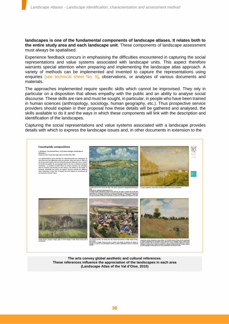
Landscape Atlases - Landscape identification, characterisation and assessment method
36
landscapes is one of the fundamental components of landscape atlases. It relates both to the entire study area and each landscape unit. These components of landscape assessment must always be spatialised.
Experience feedback concurs in emphasising the difficulties encountered in capturing the social representations and value systems associated with landscape units. This aspect therefore warrants special attention when preparing and implementing the landscape atlas approach. A variety of methods can be implemented and invented to capture the representations using enquiries [see technical sheet No. 5], observations, or analyses of various documents and materials.
The approaches implemented require specific skills which cannot be improvised. They rely in particular on a disposition that allows empathy with the public and an ability to analyse social discourse. These skills are rare and must be sought, in particular, in people who have been trained in human sciences (anthropology, sociology, human geography, etc.). Thus prospective service providers should explain in their proposal how these details will be gathered and analysed, the skills available to do it and the ways in which these components will link with the description and identification of the landscapes.
Capturing the social representations and value systems associated with a landscape provides details with which to express the landscape issues and, in other documents in extension to the
The arts convey global aesthetic and cultural references. These references influence the appreciation of the landscapes in each area
(Landscape Atlas of the Val d’Oise, 2010)
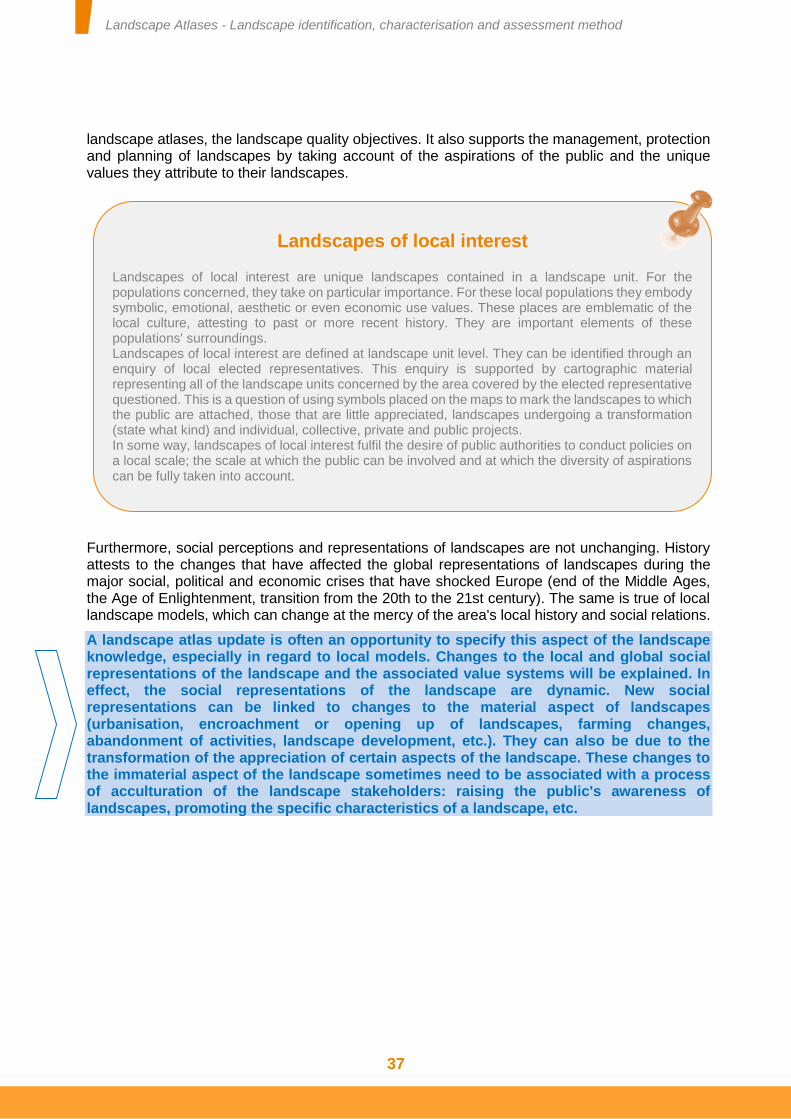
Landscape Atlases - Landscape identification, characterisation and assessment method
37
landscape atlases, the landscape quality objectives. It also supports the management, protection and planning of landscapes by taking account of the aspirations of the public and the unique values they attribute to their landscapes.
Furthermore, social perceptions and representations of landscapes are not unchanging. History attests to the changes that have affected the global representations of landscapes during the major social, political and economic crises that have shocked Europe (end of the Middle Ages, the Age of Enlightenment, transition from the 20th to the 21st century). The same is true of local landscape models, which can change at the mercy of the area's local history and social relations.
A landscape atlas update is often an opportunity to specify this aspect of the landscape knowledge, especially in regard to local models. Changes to the local and global social representations of the landscape and the associated value systems will be explained. In effect, the social representations of the landscape are dynamic. New social representations can be linked to changes to the material aspect of landscapes (urbanisation, encroachment or opening up of landscapes, farming changes, abandonment of activities, landscape development, etc.). They can also be due to the transformation of the appreciation of certain aspects of the landscape. These changes to the immaterial aspect of the landscape sometimes need to be associated with a process of acculturation of the landscape stakeholders: raising the public's awareness of landscapes, promoting the specific characteristics of a landscape, etc.
Landscapes of local interest
Landscapes of local interest are unique landscapes contained in a landscape unit. For the populations concerned, they take on particular importance. For these local populations they embody symbolic, emotional, aesthetic or even economic use values. These places are emblematic of the local culture, attesting to past or more recent history. They are important elements of these populations' surroundings. Landscapes of local interest are defined at landscape unit level. They can be identified through an enquiry of local elected representatives. This enquiry is supported by cartographic material representing all of the landscape units concerned by the area covered by the elected representative questioned. This is a question of using symbols placed on the maps to mark the landscapes to which the public are attached, those that are little appreciated, landscapes undergoing a transformation (state what kind) and individual, collective, private and public projects. In some way, landscapes of local interest fulfil the desire of public authorities to conduct policies on a local scale; the scale at which the public can be involved and at which the diversity of aspirations can be fully taken into account.
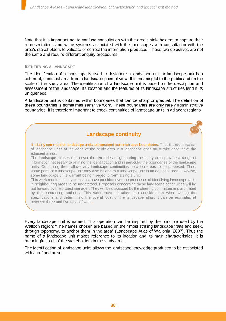
Landscape Atlases - Landscape identification, characterisation and assessment method
38
Note that it is important not to confuse consultation with the area's stakeholders to capture their representations and value systems associated with the landscapes with consultation with the area's stakeholders to validate or correct the information produced. These two objectives are not the same and require different enquiry procedures.
IDENTIFYING A LANDSCAPE
The identification of a landscape is used to designate a landscape unit. A landscape unit is a coherent, continual area from a landscape point of view. It is meaningful to the public and on the scale of the study area. The identification of a landscape unit is based on the description and assessment of the landscape. Its location and the features of its landscape structures lend it its uniqueness.
A landscape unit is contained within boundaries that can be sharp or gradual. The definition of these boundaries is sometimes sensitive work. These boundaries are only rarely administrative boundaries. It is therefore important to check continuities of landscape units in adjacent regions.
Every landscape unit is named. This operation can be inspired by the principle used by the Walloon region: "The names chosen are based on their most striking landscape traits and seek, through toponomy, to anchor them in the area" (Landscape Atlas of Wallonia, 2007). Thus the name of a landscape unit makes reference to its location and its main characteristics. It is meaningful to all of the stakeholders in the study area.
The identification of landscape units allows the landscape knowledge produced to be associated with a defined area.
Landscape continuity
It is fairly common for landscape units to transcend administrative boundaries. Thus the identification of landscape units at the edge of the study area in a landscape atlas must take account of the adjacent areas. The landscape atlases that cover the territories neighbouring the study area provide a range of information necessary to refining the identification and in particular the boundaries of the landscape units. Consulting them allows any landscape continuities between areas to be proposed. Thus, some parts of a landscape unit may also belong to a landscape unit in an adjacent area. Likewise, some landscape units warrant being merged to form a single unit. This work requires the systems that have presided over the processes of identifying landscape units in neighbouring areas to be understood. Proposals concerning these landscape continuities will be put forward by the project manager. They will be discussed by the steering committee and arbitrated by the contracting authority. This work must be taken into consideration when writing the specifications and determining the overall cost of the landscape atlas. It can be estimated at between three and five days of work.
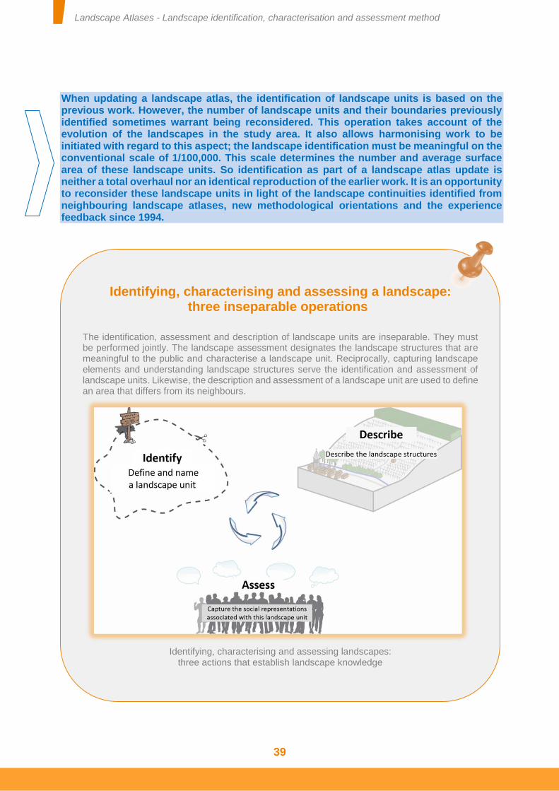
Landscape Atlases - Landscape identification, characterisation and assessment method
39
When updating a landscape atlas, the identification of landscape units is based on the previous work. However, the number of landscape units and their boundaries previously identified sometimes warrant being reconsidered. This operation takes account of the evolution of the landscapes in the study area. It also allows harmonising work to be initiated with regard to this aspect; the landscape identification must be meaningful on the conventional scale of 1/100,000. This scale determines the number and average surface area of these landscape units. So identification as part of a landscape atlas update is neither a total overhaul nor an identical reproduction of the earlier work. It is an opportunity to reconsider these landscape units in light of the landscape continuities identified from neighbouring landscape atlases, new methodological orientations and the experience feedback since 1994.
Identifying, characterising and assessing a landscape: three inseparable operations
The identification, assessment and description of landscape units are inseparable. They must be performed jointly. The landscape assessment designates the landscape structures that are meaningful to the public and characterise a landscape unit. Reciprocally, capturing landscape elements and understanding landscape structures serve the identification and assessment of landscape units. Likewise, the description and assessment of a landscape unit are used to define an area that differs from its neighbours.
Identifying, characterising and assessing landscapes:
three actions that establish landscape knowledge
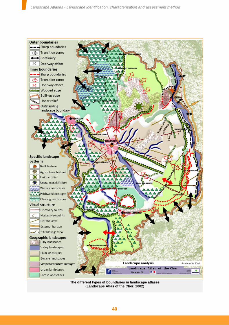
Landscape Atlases - Landscape identification, characterisation and assessment method
40
The different types of boundaries in landscape atlases (Landscape Atlas of the Cher, 2002)
Landscape Atlases - Landscape identification, characterisation and assessment method
41
LANDSCAPE PROCESSES
As stated above, a landscape's evolution is generally linked to variations in different landscape evolution mechanisms. These concern the material and immaterial aspects of the landscapes. Because these landscape evolution mechanisms have their own time scales, landscape atlases include different time scales. The features of each study area and each landscape unit guide the analysis of these landscape processes. However, some points of reference can be established.
In terms of the study area, it tends to be the global evolution mechanisms that are studied. This analysis is based on historic documents. The selection of the evolution mechanisms taken into account is guided by the existence of clearly perceptible traces in the current landscapes, both physically and in the social representations associated with them.
For each landscape unit, it is particularly important to focus on reporting the changes that concern the characteristic landscape structures and landscape elements. These landscape processes contribute to identifying various landscape issues.
Reporting landscape processes It is not easy to report a landscape's evolution or variations in its evolution mechanisms. Maps are particularly well suited to localising landscape evolution but have difficulty in illustrating it. Sketches, drawings and photographs are an easier way of reporting it. So landscape evolution can usefully be reported using dyptichs or diachronic series of photos. However, it appears preferable to use block diagrams, which are simpler and can therefore highlight the important or significant aspects of this landscape evolution. A landscape's evolution mechanisms may be reported in different manners according to their nature. Curves, tables and graphics must not be disregarded. They allow the force of the landscape's evolution mechanisms to be clearly reported, knowing that this force does not account for all landscape evolution. For some of a landscape's evolution mechanisms, it is important to use a map, especially when the spatial distribution of these mechanisms is not uniform.
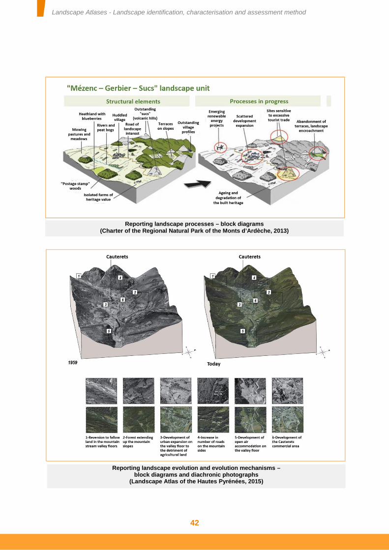
Landscape Atlases - Landscape identification, characterisation and assessment method
42
Reporting landscape processes – block diagrams (Charter of the Regional Natural Park of the Monts d’Ardèche, 2013)
Reporting landscape evolution and evolution mechanisms – block diagrams and diachronic photographs
(Landscape Atlas of the Hautes Pyrénées, 2015)
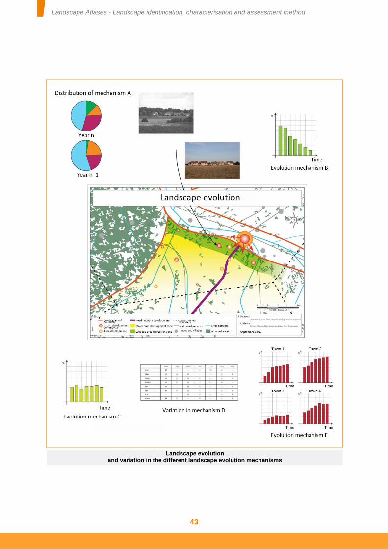
Landscape Atlases - Landscape identification, characterisation and assessment method
43
Landscape evolution and variation in the different landscape evolution mechanisms
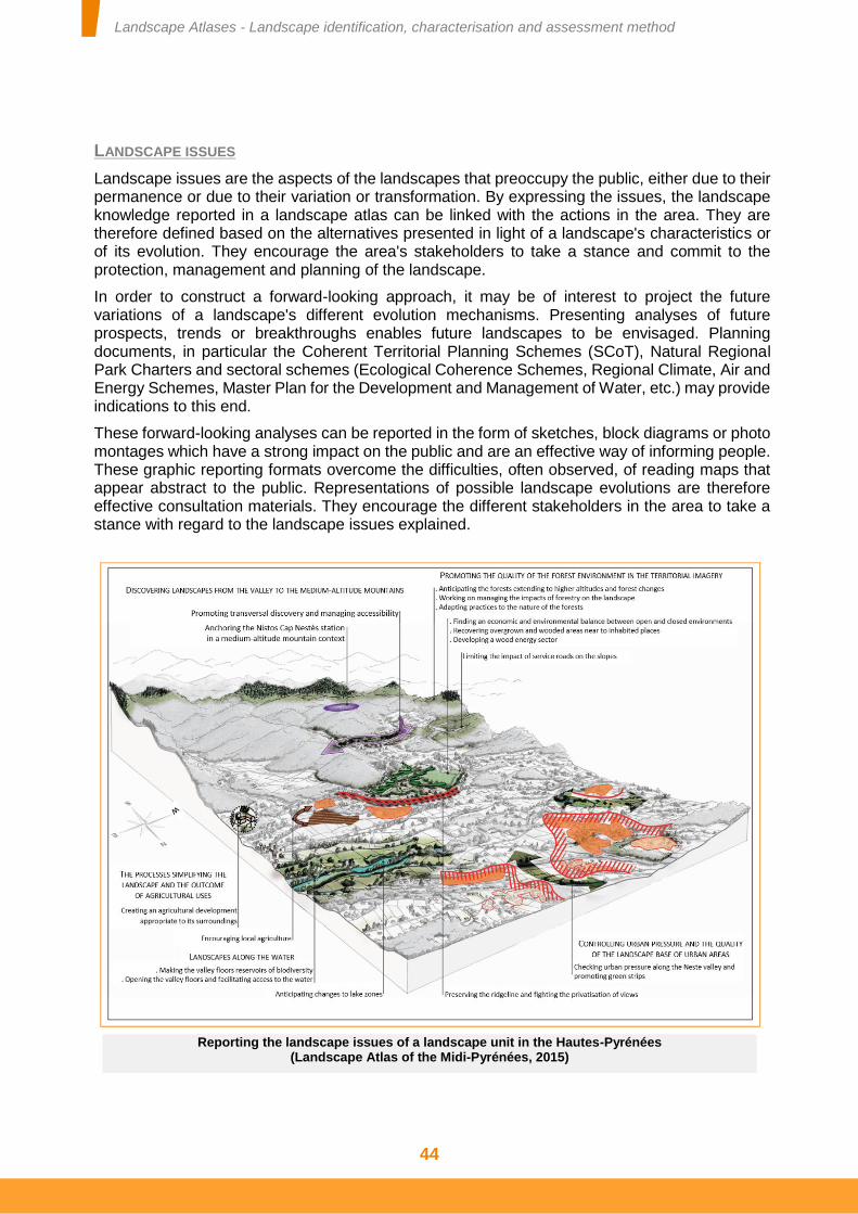
Landscape Atlases - Landscape identification, characterisation and assessment method
44
LANDSCAPE ISSUES
Landscape issues are the aspects of the landscapes that preoccupy the public, either due to their permanence or due to their variation or transformation. By expressing the issues, the landscape knowledge reported in a landscape atlas can be linked with the actions in the area. They are therefore defined based on the alternatives presented in light of a landscape's characteristics or of its evolution. They encourage the area's stakeholders to take a stance and commit to the protection, management and planning of the landscape.
In order to construct a forward-looking approach, it may be of interest to project the future variations of a landscape's different evolution mechanisms. Presenting analyses of future prospects, trends or breakthroughs enables future landscapes to be envisaged. Planning documents, in particular the Coherent Territorial Planning Schemes (SCoT), Natural Regional Park Charters and sectoral schemes (Ecological Coherence Schemes, Regional Climate, Air and Energy Schemes, Master Plan for the Development and Management of Water, etc.) may provide indications to this end.
These forward-looking analyses can be reported in the form of sketches, block diagrams or photo montages which have a strong impact on the public and are an effective way of informing people. These graphic reporting formats overcome the difficulties, often observed, of reading maps that appear abstract to the public. Representations of possible landscape evolutions are therefore effective consultation materials. They encourage the different stakeholders in the area to take a stance with regard to the landscape issues explained.
Reporting the landscape issues of a landscape unit in the Hautes-Pyrénées (Landscape Atlas of the Midi-Pyrénées, 2015)
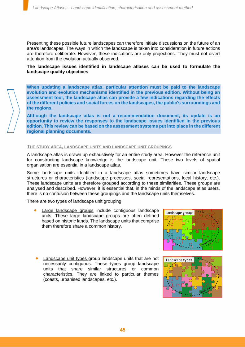
Landscape Atlases - Landscape identification, characterisation and assessment method
45
Presenting these possible future landscapes can therefore initiate discussions on the future of an area's landscapes. The ways in which the landscape is taken into consideration in future actions are therefore deliberate. However, these indications are only projections. They must not divert attention from the evolution actually observed.
The landscape issues identified in landscape atlases can be used to formulate the landscape quality objectives.
When updating a landscape atlas, particular attention must be paid to the landscape evolution and evolution mechanisms identified in the previous edition. Without being an assessment tool, the landscape atlas can provide a few indications regarding the effects of the different policies and social forces on the landscapes, the public's surroundings and the regions.
Although the landscape atlas is not a recommendation document, its update is an opportunity to review the responses to the landscape issues identified in the previous edition. This review can be based on the assessment systems put into place in the different regional planning documents.
THE STUDY AREA, LANDSCAPE UNITS AND LANDSCAPE UNIT GROUPINGS
A landscape atlas is drawn up exhaustively for an entire study area. However the reference unit for constructing landscape knowledge is the landscape unit. These two levels of spatial organisation are essential in a landscape atlas.
Some landscape units identified in a landscape atlas sometimes have similar landscape structures or characteristics (landscape processes, social representations, local history, etc.). These landscape units are therefore grouped according to these similarities. These groups are analysed and described. However, it is essential that, in the minds of the landscape atlas users, there is no confusion between these groupings and the landscape units themselves.
There are two types of landscape unit grouping:
Large landscape groups include contiguous landscape units. These large landscape groups are often defined based on historic lands. The landscape units that comprise them therefore share a common history.
Landscape unit types group landscape units that are not necessarily contiguous. These types group landscape units that share similar structures or common characteristics. They are linked to particular themes (coasts, urbanised landscapes, etc.).
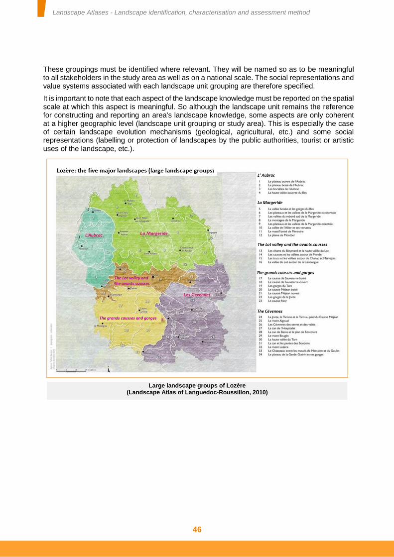
Landscape Atlases - Landscape identification, characterisation and assessment method
46
These groupings must be identified where relevant. They will be named so as to be meaningful to all stakeholders in the study area as well as on a national scale. The social representations and value systems associated with each landscape unit grouping are therefore specified.
It is important to note that each aspect of the landscape knowledge must be reported on the spatial scale at which this aspect is meaningful. So although the landscape unit remains the reference for constructing and reporting an area's landscape knowledge, some aspects are only coherent at a higher geographic level (landscape unit grouping or study area). This is especially the case of certain landscape evolution mechanisms (geological, agricultural, etc.) and some social representations (labelling or protection of landscapes by the public authorities, tourist or artistic uses of the landscape, etc.).
Large landscape groups of Lozère (Landscape Atlas of Languedoc-Roussillon, 2010)
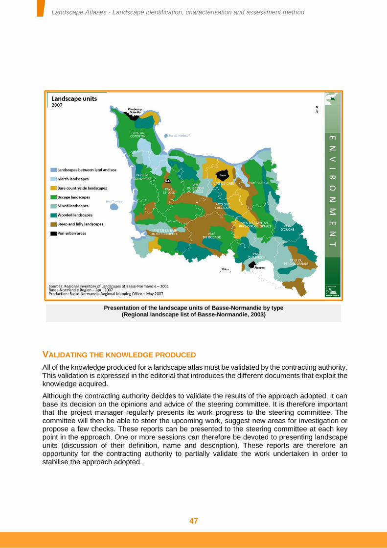
Landscape Atlases - Landscape identification, characterisation and assessment method
47
VALIDATING THE KNOWLEDGE PRODUCED
All of the knowledge produced for a landscape atlas must be validated by the contracting authority. This validation is expressed in the editorial that introduces the different documents that exploit the knowledge acquired.
Although the contracting authority decides to validate the results of the approach adopted, it can base its decision on the opinions and advice of the steering committee. It is therefore important that the project manager regularly presents its work progress to the steering committee. The committee will then be able to steer the upcoming work, suggest new areas for investigation or propose a few checks. These reports can be presented to the steering committee at each key point in the approach. One or more sessions can therefore be devoted to presenting landscape units (discussion of their definition, name and description). These reports are therefore an opportunity for the contracting authority to partially validate the work undertaken in order to stabilise the approach adopted.
Presentation of the landscape units of Basse-Normandie by type (Regional landscape list of Basse-Normandie, 2003)
Landscape Atlases - Landscape identification, characterisation and assessment method
48
LANDSCAPE ATLAS REQUIREMENTS
The different components of knowledge required of a landscape atlas are organised around:
Two levels of reporting: the study area and each landscape unit.
The different exploitation formats planned according, in particular, to the target audiences [see technical sheet No. 7].
The reporting of the landscape knowledge is irrefutably based on a range of tools: text, sketches, drawings, photographs, maps, etc. [see technical sheet No. 6]. However, there are minimum requirements of a landscape atlas. These requirements are neither exclusive nor limiting. They can be added to by proposals made by the different stakeholders in the landscape atlas or introduced by various innovations.
The use of maps and block diagrams in landscape atlases is particularly recommended. It is important that these maps include the parts of the regions adjacent to the mapped area. This highlights the landscape continuities between the study area and the adjacent regions. It also allows the nature of the boundaries between landscape units to be represented (sharp or gradual boundaries).
The knowledge acquired in a landscape atlas is reported at study area and landscape unit level and, if relevant, at landscape unit grouping level.
REQUIREMENTS AT STUDY AREA LEVEL
At study area level, the social representations and value systems associated with the landscapes that are meaningful on this scale are analysed. The variations in landscape evolution mechanisms and the landscape evolution are stated. The associated landscape issues are described.
All of this information appears on maps presenting the study area. The project manager therefore requires several maps. These are:
A map showing all of the landscape units in the study area. This map reports on all of the landscape units in the study area and, at least partially, the landscape units that border it. The name of each landscape unit is written on the map. Likewise, the nature of the boundaries between the landscape units is stated in a key (sharp, fuzzy, etc.),
Thematic maps showing the landscape evolution mechanisms and landscape transformations affecting the study area,
Thematic maps of the areas considered outstanding on the scale of the study area (protected and labelled areas, landscapes mentioned in tourist guides, spatialisation of scholarly representations, etc.),
Maps showing the locations of landscape issues on the study area scale.
Where applicable, these thematic maps may be produced for each landscape unit grouping.
The map presenting all of the landscape units in the study area, embellished with thematic maps, can usefully be printed on a large format poster (A0). This poster can easily be displayed and is an important tool for raising awareness among the regions' stakeholders of the variety of landscapes in the study area and their main characteristics.
Landscape Atlases - Landscape identification, characterisation and assessment method
49
LANDSCAPE UNIT GROUPINGS
If relevant, the landscape unit groupings (types or large groups) are introduced in the section devoted to the study area. However, they can be described either as part of the presentation of the study area or in the presentation of the landscape units. In effect, the presentation of each grouping can give structure to that of the different landscape units (umbrella to the different sections devoted to the landscape units).
The social representations and value systems associated with each landscape unit grouping are specified. Both the types and groups of landscape units are described in terms of the landscape structures or aspects of the landscapes common to all of the landscape units they contain. Text therefore details the characteristics of these groups, the forces that affect them and the issues specific to them.
For an update, if the original landscape atlas did not include these groupings and they prove relevant, they must be identified. If groupings have already been identified in the original landscape atlas, it is necessary to check the appropriateness of their boundaries and whether transformations have occurred to modify them.
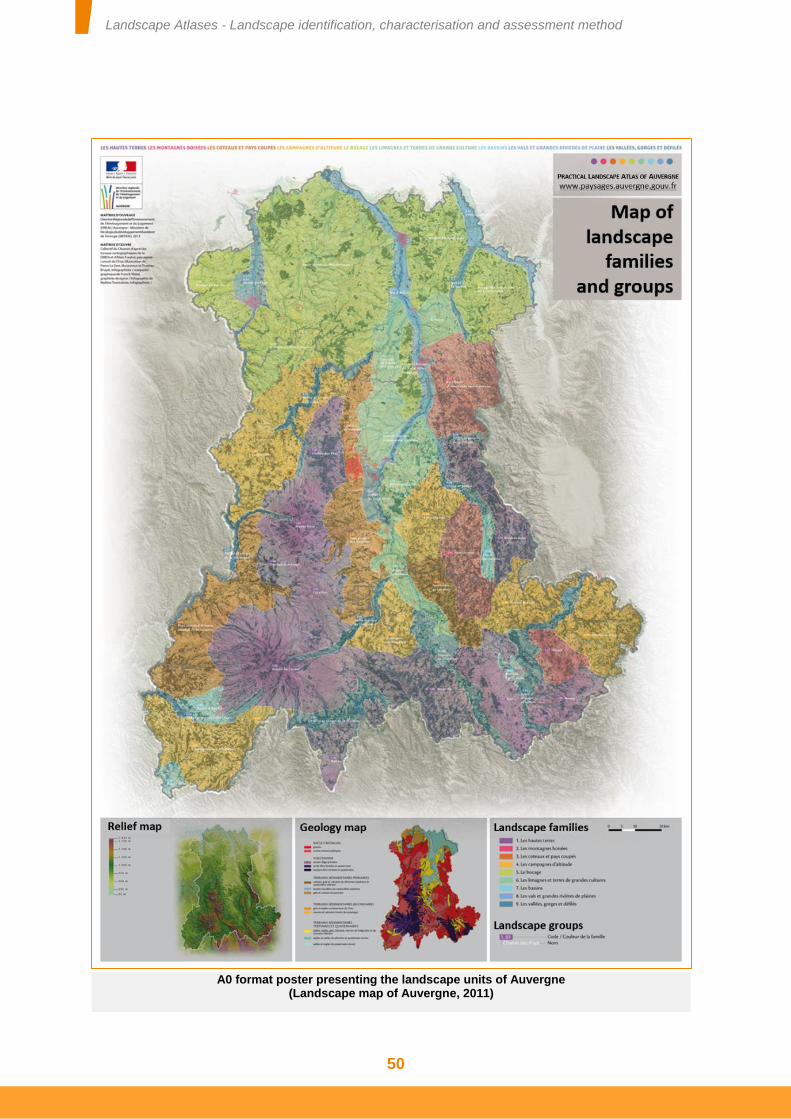
Landscape Atlases - Landscape identification, characterisation and assessment method
50
A0 format poster presenting the landscape units of Auvergne (Landscape map of Auvergne, 2011)
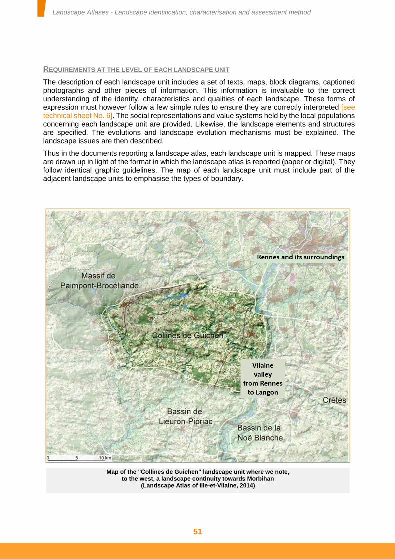
Landscape Atlases - Landscape identification, characterisation and assessment method
51
REQUIREMENTS AT THE LEVEL OF EACH LANDSCAPE UNIT
The description of each landscape unit includes a set of texts, maps, block diagrams, captioned photographs and other pieces of information. This information is invaluable to the correct understanding of the identity, characteristics and qualities of each landscape. These forms of expression must however follow a few simple rules to ensure they are correctly interpreted [see technical sheet No. 6]. The social representations and value systems held by the local populations concerning each landscape unit are provided. Likewise, the landscape elements and structures are specified. The evolutions and landscape evolution mechanisms must be explained. The landscape issues are then described.
Thus in the documents reporting a landscape atlas, each landscape unit is mapped. These maps are drawn up in light of the format in which the landscape atlas is reported (paper or digital). They follow identical graphic guidelines. The map of each landscape unit must include part of the adjacent landscape units to emphasise the types of boundary.
Map of the "Collines de Guichen" landscape unit where we note, to the west, a landscape continuity towards Morbihan
(Landscape Atlas of Ille-et-Vilaine, 2014)
Landscape Atlases - Landscape identification, characterisation and assessment method
52
Several maps are therefore required for each landscape unit. These maps are used:
to spatialise the landscape structures,
to spatialise the most characteristic landscape elements and the different landscapes of local interest,
to spatialise the landscape evolution mechanisms or the transformations to this landscape,
to spatialise the landscape issues.
For each of these maps, a location inset is used to situate the landscape unit within the study area.
The municipality is a convenient administrative level, still frequently used for regional planning. Yet a landscape unit concerns several municipalities, in whole or in part. A list of these municipalities may therefore be provided. Likewise, for each municipality, the landscape units that concern it may be indicated at the back of the landscape atlas.
When updating a landscape atlas, the transformations to the characteristics and qualities of each landscape unit must be emphasised. Some landscape unit boundaries may have changed: they have perhaps been moved, refined or, on the contrary, extended to a larger transition zone. It may also be that some landscape units have appeared and that others have disappeared.
In the most extreme cases, the evolution observed may lead to the names of certain landscape units identified in the previous landscape atlases being reconsidered.
LANDSCAPE UNIT PROFILE
It is useful to have summary information on the identification, description and assessment of each landscape unit. This allows information to be quickly obtained on all of the landscape units in a "département" or region. It provides an overview of the landscape units neighbouring that studied. Finally, it provides uniform information on all of the landscape units in France.
Thus each section devoted to a landscape unit includes an inset presenting the "profile" of that unit. This profile is a summary of the information relating to its identification, description and assessment. It is presented in the form of a short text and illustrations on a single page (of a book or report), or a single screen on a computer.
The title of this profile is the name of the landscape unit. A short paragraph describes the landscape structures characteristic of the landscape unit as well as, where applicable, the most characteristic landscape elements. A second paragraph addresses the social representations of the landscape unit and indicates the main landscapes of local interest. A third paragraph indicates the transformations to the landscape unit and the evolution mechanisms that cause them. It concludes with the major issues of this landscape unit.
This text is complemented by the map of the landscape unit, an inset showing the location of the unit within the study area and a block diagram of the landscape unit presenting its characteristic components (landscape elements and structures). The three paragraphs and block diagram are used as a key to the map of the landscape unit.
Landscape Atlases - Landscape identification, characterisation and assessment method
53
4- Distributing and exploiting the knowledge acquired
he way in which the different data and information collected for a landscape atlas are reported is guided by the specifications. There are now numerous formats for exploiting the landscape atlas approach. These are very briefly discussed in the paragraphs below,
less to specify them than to emphasise their diversity and differences. These forms of reporting a landscape atlas's information must be anticipated from the outset of the approach.
The conditions for accessing the landscape information must also be addressed. These are considered when writing the specifications. The landscape data and technical conditions of its reuse are also discussed.
THE DIFFERENT LANDSCAPE ATLAS EXPLOITATION FORMATS
The landscape atlases currently published give rise to different types of document. They can be in digital format or printed on paper. They can be summary documents or sets of information formalised for analytical purposes. These two aspects of digital/printed and summary/analytical must not be confused. The table below illustrates these differences.
The creation or update of a landscape atlas can therefore give rise to several different types of exploitation. The information and data in the landscape atlases must be exploited in two ways.
The first of these must be defined from the outset of the approach, when writing the specifications. The project manager must provide at least three materials reporting his work:
A summary presenting the landscape aspects of the study area and each landscape unit. This is the main summary of the information collected and analysed as part of the landscape atlas approach. This is the core of the landscape atlas. The form of this summary is determined by the contracting authority.
A poster presenting the different landscape units in the study area, any groupings they belong to and the landscape characteristics and issues of relevance on this scale.
One or more landscape databases [see technical sheet No. 8].
The second of these ways of exploiting the information and data acquired for the landscape atlas can be considered as opportunities and needs arise. These may be additional digital documents,
T
Digital format Printed format
Summary documents
Report or document facsimiles accessible on CD-Rom, DVD-Rom or the Internet
Summary books, reports, documents and maps
Analytical documents Databases and information systems available on digital media
Data files (tables, zoning maps, etc.)
Landscape Atlases - Landscape identification, characterisation and assessment method
54
technical sheets, summary pamphlets, exhibitions and so on. These forms of exploitation are based on the work undertaken as part of the landscape atlas approach but do not necessarily have to be implemented by the project manager of this approach.
LANDSCAPE ATLAS STYLE AND CONTENT
The format of reporting the landscape atlas must be considered according to the recipients of these landscape knowledge tools. The style and content of these reports are linked. Landscape atlases are liable to be aimed at several audiences. Debates on the destination of this shared knowledge base have identified four types of stakeholder:
Civil society, the public (citizens and residents), associations and economic operators;
Elected representatives and decision-makers for the region concerned, whether or not they are familiar with landscape questions;
The technical departments and operators who establish sectoral studies and prepare files;
Landscape specialists.
Summary information and basic data: the place of databases and geographical information systems
in landscape atlases The information in the landscape atlases is presented in two forms: summary information and basic data. The summary information is sufficient to identify, describe and assess a landscape. It brings together and summarises numerous pieces of thematic data and information. It attests to the complexity of the landscapes and the uniqueness of each of them. The basic data is necessary but under no circumstances is it sufficient to identify, describe and assess a landscape. Each piece of basic data describes or addresses one aspect of the landscape and it is the combination of these aspects that is used to describe this landscape. Nonetheless, some basic data can be formalised in a controlled system. This data can be organised and stored in systems enabling it to be rapidly distributed and easily compared. Likewise, to be exploitable, this data should make reference to closed lists of nomenclatures whenever possible. This data can be stored in databases and geographical information systems which must be interoperable with other regional information systems [see technical sheet No. 8]. These databases and information systems therefore appear to be decision-making support tools, even if the data they provide must be complemented, in particular by landscape structures, and interpreted by landscape specialists.
Landscape Atlases - Landscape identification, characterisation and assessment method
55
There are four main functions of landscape atlases:
Regional promotion. Because the landscape is an important aspect of the public's surroundings, revealing the quality and diversity of the landscapes contributes to promoting this living environment and the areas in which it falls.
Raising awareness among both the public and elected representatives and their technical departments of the interest that should be taken in landscapes, the issues associated with them and the protection, management and planning of landscapes. This function aids discussion.
Providing information underpinning decisions relating to regional planning, the implementation of sectoral policies and the protection, management and planning of landscapes. This function aids decision-making.
Promoting interaction between stakeholders in the landscape (including non-specialists), contributing to building and sustaining networks of landscape stakeholders. This function is of linking.
None of these functions is to be ignored but they must not be confused, at risk of interfering with the directions taken for the landscape atlas and producing documents poorly suited to their objectives and their audience.
The format of a document (style) must not be confused with what it contains (content). However, these two aspects are linked. They must be considered in accordance with the target functions. These functions are defined by the contracting authority, assisted by the steering committee, when writing the specifications.
Although all of the landscape atlas's functions are legitimate, it is essential to distinguish them according to their respective importance. The Guidelines for the implementation of the European Landscape Convention emphasise the fact that "The identification, description and assessment of landscapes constitute the preliminary phase of any landscape policy*". It is therefore recommended that the functions [and associated reporting formats - see technical sheet No. 7] be retained in descending order of priority:
Organising the network of landscape stakeholders: this function is provided by creating the landscape atlas itself.
Aiding discussion: the format of the material varies but it is recommended to produce at least one summary map of the landscape units and a summary document (paper or digital). These reporting formats may serve to "increase awareness among the civil society, private organisations, and public authorities of the value of landscapes, their role and changes to them" (art. 6 of the European Landscape Convention).
Providing a decision-making aid to integrate landscape into various sectoral policies and fields of activity: it is therefore necessary to organise and formalise the information used to create or update the landscape atlas. This information must be able to be easily reused by other stakeholders who are not landscape specialists. Constructing and entering information into local databases and Geographical Information Systems [see appendix 4].
Finally, conducting regional promotion: this may be a secondary effect of the summary document but may also be based on a variety of subsequent exploitations of the landscape atlas (exhibitions, pamphlets, etc.).
Landscape Atlases - Landscape identification, characterisation and assessment method
56
A PAPER DOCUMENT OR A DIGITAL TOOL?
The body of the landscape atlas can be designed to be a document or report published on paper or be designed as an interactive digital tool. These two reporting formats are not the same but they are not exclusive of one another. They have neither the same functions nor the same costs and they rely on different skills. Note that digitising a paper document (facsimile) is not a digital tool per se.
It is commonly thought that the digital format of the documents produced enables the landscape knowledge to be better distributed, thus enhancing the awareness of landscape issues. This conception must be tempered. Of course the digital format allows information to be distributed quickly and at low cost. However, digital documents are never consulted by chance. An intention is needed. Some documents, stored on media such as DVDs and CD-Roms, are not in print and therefore not or hardly accessible. However, books remain highly appreciated by the public and elected representatives alike. A map on display is easily consulted or at least viewed, arousing a certain amount of curiosity in the various landscapes represented. Furthermore, some digital documents are difficult to use. To be able to be consulted without an Internet connection or be exploited for uses other than reading, digital documents must offer certain functions: be easy to download, offer the possibility of extracting sections, etc.
Testimonial Different landscape atlas exploitation formats:
the example of the Landscape Atlas of Poitou-Charentes
The State and Region appointed the Poitou-Charentes Regional Conservatory of Natural Areas (CREN) as contracting authority for the Landscape Atlas of Poitou-Charentes (1997-1999), giving rise to the "Landscape branch". As the quality and relevance of the work was underlined from 1999, it was decided to maintain this branch to distribute and exploit the productions. In order to compensate for a reduced paper edition (300 initial copies intended only for the "regional landscape stakeholders"), the work focussed on a digital exploitation to widen this distribution: the descriptive writings on the landscape units were therefore brought together on a CD and little by little placed online on the ORE* website. Boosted by the reuse of the regional landscape map in different publications, as well as by the technical assistance work conducted in the field by the CREN landscape architects, knowledge of the atlas's existence increased. Although we were deepening our knowledge of the region's landscapes through this process every day, we awarded the production of descriptive illustrations of the landscape units (block diagrams, sketches, etc.) to "external" landscape architects and graphic designers. Around sixty illustrations were created between 2002 and 2008. Finally, more recently, in addition to the publication of the Guide to the Landscape in Poitou-Charentes, the CREN has staged an exhibition on the landscapes which is touring the schools, town halls and media libraries that request it. To find out more: www.cren-poitou-charentes.org.
Jean-Philippe Minier, landscape architect, Head of landscape branch, Poitou-Charentes CREN
(*) The Regional Environmental Observatory is a partnership organisation that brings together and distributes environmental data in Poitou-Charentes
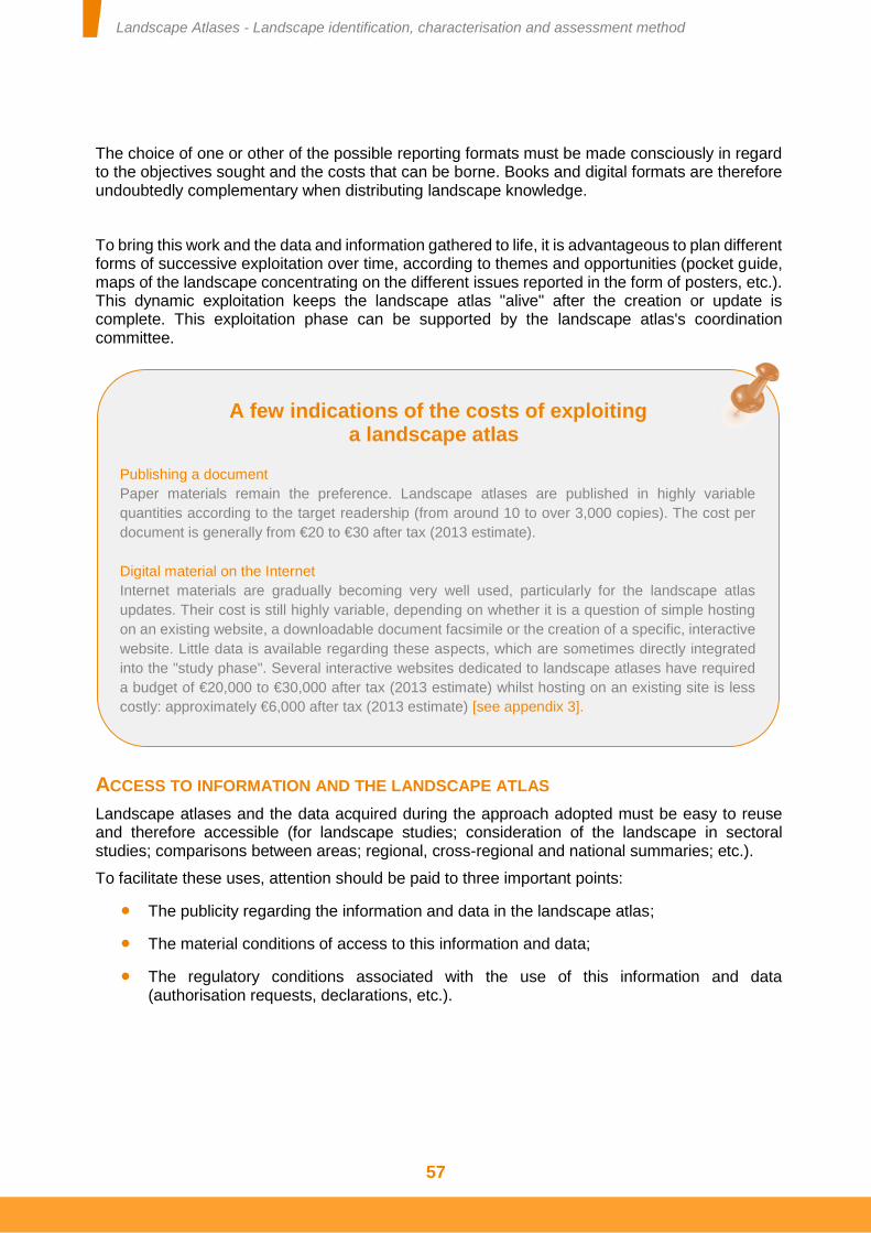
Landscape Atlases - Landscape identification, characterisation and assessment method
57
The choice of one or other of the possible reporting formats must be made consciously in regard to the objectives sought and the costs that can be borne. Books and digital formats are therefore undoubtedly complementary when distributing landscape knowledge.
To bring this work and the data and information gathered to life, it is advantageous to plan different forms of successive exploitation over time, according to themes and opportunities (pocket guide, maps of the landscape concentrating on the different issues reported in the form of posters, etc.). This dynamic exploitation keeps the landscape atlas "alive" after the creation or update is complete. This exploitation phase can be supported by the landscape atlas's coordination committee.
ACCESS TO INFORMATION AND THE LANDSCAPE ATLAS
Landscape atlases and the data acquired during the approach adopted must be easy to reuse and therefore accessible (for landscape studies; consideration of the landscape in sectoral studies; comparisons between areas; regional, cross-regional and national summaries; etc.).
To facilitate these uses, attention should be paid to three important points:
The publicity regarding the information and data in the landscape atlas;
The material conditions of access to this information and data;
The regulatory conditions associated with the use of this information and data (authorisation requests, declarations, etc.).
A few indications of the costs of exploiting a landscape atlas
Publishing a document
Paper materials remain the preference. Landscape atlases are published in highly variable
quantities according to the target readership (from around 10 to over 3,000 copies). The cost per
document is generally from €20 to €30 after tax (2013 estimate).
Digital material on the Internet
Internet materials are gradually becoming very well used, particularly for the landscape atlas
updates. Their cost is still highly variable, depending on whether it is a question of simple hosting
on an existing website, a downloadable document facsimile or the creation of a specific, interactive
website. Little data is available regarding these aspects, which are sometimes directly integrated
into the "study phase". Several interactive websites dedicated to landscape atlases have required
a budget of €20,000 to €30,000 after tax (2013 estimate) whilst hosting on an existing site is less
costly: approximately €6,000 after tax (2013 estimate) [see appendix 3].
Landscape Atlases - Landscape identification, characterisation and assessment method
58
LANDSCAPE ATLAS PUBLICITY
The information and data produced for landscape atlases must be widely publicised. This publicity widely exceeds the scope of the study area. It can be deployed on a national scale, for example by referencing each landscape atlas and associated database on the French public open data platform data.gouv.fr. This platform has the advantage of presenting all of the types of data and allowing very wide publicity.
These aspects must be managed by the contracting authority. To this end, the contracting authority can be supported by the services offered by the ministry responsible for the environment (see appendices).
With regard to summary documents, it is advisable to procure them an ISBN (International Standard Bookl Number). This ISBN is the standard international code used to identify any serial publication, independently of the medium (printed, online resource, CD-ROM, DVD-ROM, DVD video, etc.). This ISBN boosts the referencing of the landscape atlas and therefore its wide distribution. The National Library of France provides all the details should you wish to find out more and obtain an ISBN.
MATERIAL CONDITIONS OF ACCESSING THE LANDSCAPE ATLAS'S INFORMATION
To facilitate the distribution of the summary information contained in the landscape atlases, it is advisable to provide it as a download from a well-referenced website. Each document, especially the facsimile of the main landscape atlas document, must be able to be downloaded as a single file.
However, it is essential that the exploitation formats of the landscape atlas and some of its components (maps, illustrations, etc.) are of sufficient quality to be easily reused. Although it may be advantageous to reduce the resolution of the digital versions of some illustrations to limit the file size, it must also be possible to obtain these illustrations in their maximum quality.
It is therefore not sufficient for some illustrations to just be inserted in the summary texts. They must also be presented in separate files. In addition, this data must be accompanied with metadata enabling the user to date and locate it (in the case of localisable data) and obtain information on its authors. If several files are associated with the distribution of these documents, the ergonomics, organisation and naming of these files must ensure easy use. This ease of access must be planned when writing the specifications.
Furthermore, it is not advisable to use presentation software for the landscape atlas if it does not allow the digital version of the landscape atlas's main summary document to be downloaded or cannot be installed free of charge on any operating system or interface equipped with a screen (tablet, etc.).
Landscape Atlases - Landscape identification, characterisation and assessment method
59
REGULATORY CONDITIONS OF USING OR REUSING DATA AND INFORMATION
Landscape is a component of the environment and of people's surroundings. The Aarhus Convention of 25 June 1998 and the European Landscape Convention state that environmental knowledge must be made accessible to as many people as possible. In addition, the landscape atlas approach is supported by public funds. All of the data and information acquired when creating or updating a landscape atlas should therefore be copyright-free.
This freedom of use applies to the summary information produced as part of this work as well as the working data gathered to create or update the landscape atlas (photographs taken in the field, geolocation of landscape elements, etc.). In particular, digital documents must not be protected against being saved, printed or copied. Finally, the formatting of public data necessary to creating or updating a landscape atlas should also be transferred to the contracting authority so that this data thus organised can be reused for other landscape studies.
It is undoubtedly useful to reiterate that a document can only be granted intellectual property rights if it is an intellectual work in accordance with the intellectual property code, namely that it presents a certain amount of originality, defined in jurisprudence as the imprint of the personality of its author's work. As the landscape atlases have to follow a common approach to produce balanced information of use to public action, and as this approach is guided by this method, it is highly unlikely that landscape atlases fall within this scenario.
However, the moral rights of the authors must be safeguarded by requiring every use and reuse of the information and data contained in the landscape atlases to mention its authors and respect the integrity of this information. A notice could be worded as follows: "Reuse of these contents is free provided it complies with the legislation in force and the reference to the sources is maintained".
The transfer of the rights to exploit the data and information contained in a landscape atlas can be underpinned by the proposals contained in the order of 16 September 2009 relating to the approval of the general administrative terms and conditions applicable to public contracts for intellectual services. Article 25 of this order stipulates two options:
Option A, which invites the contract holder to transfer "on a non-exclusive basis to the contracting authority and third parties named in the contract, the proprietary rights to literary and artistic property pertaining to the results, for the needs arising from the purpose of the contract". The transfer is valid for a determined duration and scope.
Option B proposes that "the contract holder transfers to the contracting authority, the proprietary rights to literary and artistic property pertaining to the results for the territory, duration and modes of exploitation of the rights transferred" and in particular "the right to distribute the results for commercial purposes for the modes of exploitation stipulated in the specific documents of the contract". This option will be preferred [see technical sheet No. 9]. It enables the contracting authority to freely exploit the results of the landscape atlas, including for commercial purposes (distribution of these results to perform impact studies or any other study of use to the protection, management and planning of landscapes). In addition, once they have been transferred, the rights attributed to the results of the landscape atlas will not be an obstacle to updating the content of the landscape atlas.
Landscape Atlases - Landscape identification, characterisation and assessment method
60
PROVISION OF THE DATA ACQUIRED
The European Landscape Convention enjoins each signatory party to "integrate landscape into its regional and town planning policies and in its cultural, environmental, agricultural, social and economic policies, as well as in any other policies with possible direct or indirect impact on landscape" (art. 5). The use and reuse of reliable data and information are probably the main conditions of this. The creation or update of a landscape atlas is the opportunity to collect and bring together all reliable and locally validated data on landscapes.
The creation or update of a landscape atlas therefore offers the opportunity to make this type of data accessible. It can then be reused in order, in particular, to facilitate landscape studies on other scales and the consideration of landscape in various sectoral operations.
When the data used to create or update a landscape atlas is private data, the project management must produce a detailed list of the sources used so that these details can be found again if need be. A reference to the source of the information must be inserted when it is alluded to in the text or illustrations in the landscape atlas.
As one of the services provided as part of the contract for creating or updating a landscape atlas, it falls to the contract holder to provide results free of all rights. If this were not the case, the contract holder would assume responsibility without that of the institution being sought.
The public character of the information contained in the landscape atlases
The information that makes up the landscape atlases is provided both by institutions and the selected service providers. It can be qualified as "public information" pursuant to the 1st article of French law No. 78-753 of 17 July 1978 modified introducing various measures to improve relations between institutions and the public and various administrative, social and fiscal provisions, known as the CADA law. This article requires that "irrespective of their date, place of conservation, format and medium, the documents produced or received by the State or regional authorities as part of their mission of public service, or other public or private people tasked with such a mission, are considered to be administrative documents. Files, reports, studies, accounts, statistics, directives, instructions, circular memos and notes in particular constitute such documents". In environmental matters, law No. 2005-1319 of 26 October 2005 introducing various measures to adapt community law into French environmental law modified articles L. 124-1 and onwards of the French environment code, thus strengthening the requirement of institutions to communicate the information they hold in this field.
Landscape Atlases - Landscape identification, characterisation and assessment method
61
When the data used to create or update a landscape atlas is public, or this data has been acquired during the approach adopted, it must be made public. The project management must therefore provide it to the contracting authority in a format in which it can be distributed and reused. This data must therefore be considered to be the final result, to be able to be made available and distributed.
The reporting of landscape atlases must enable this data and information to be reused. The choice of format or formats for reporting landscape atlases must anticipate these reuses. Special attention must be paid:
to the quality of the illustrations presented in the summary documents, especially when these are digital,
to the inclusion or reuse of this data and information in Geographical Information Systems and tools that support the decision-making and planning for different sectoral policies.
These aspects emphasise the importance of favouring data and information reporting formats that allow this information to be superimposed on the landscapes with other information of use to the different sectoral policies (agriculture, biodiversity, transport, urban planning, etc.). Likewise, each of these pieces of data must be accompanied with metadata enabling the user to date and locate them (in the case of localisable data) and obtain information on their authors.
The specification of data must appear in the specifications. The contracting authority will include this workload in the call for tenders and ensure it has been performed correctly when reported.
Landscape Atlases - Landscape identification, characterisation and assessment method
62
Afterword
he advantage of the landscape atlas approach initiated in France 20 years ago and adopted in the different signatory countries of the European Landscape Convention is now proven. But the objectives pursued and the method of attaining them warranted being
stated and updated. The harmonisation of the approaches adopted and the formalisation of the information produced thus support the consideration of the landscape in regional planning and development. The theoretical insight associated with this method demonstrates the reliability of the knowledge produced. Landscape atlases appear to be necessary tools for public authorities to commit to the management of people's surroundings.
The methodological orientations presented herein form, in addition to the landscape atlases, a more general landscape knowledge method. This applies to various levels of territorial organisation. Based on the three concepts of landscape unit, landscape structure and landscape element, landscapes can be identified, assessed and described on all territorial scales. Landscape units therefore form, on each of these scales, a partition of the territory in question. The landscape issues specific to each of these levels of territorial organisation can be revealed.
However, the extent of the different territorial levels influences the perception of landscapes. Local landscape models in particular depend on it. On each scale, new landscapes take on a meaning. In parallel, perceptions of areas of a territory are guided by the functions attributed to this territory and the competences of those that administrate it. Landscape knowledge therefore also provides insight into the links and attachment the public have with these different areas.
Thus variations in analysis scale do not necessarily form a perfect interlocking of the different landscape units identified. The landscape units of these different areas can interlock, but can also cross and interweave, which is why the landscape knowledge and the expression of landscape issues follow the principle of subsidiarity.
Finally, the approach proposed allows a variety of landscape policies to be consciously and democratically initiated. Consciously because the social representations and value systems associated with the landscapes are explained objectively. These values concern all sections of the public and do not require the personal assessment of the person reporting them. Democratically because, in response to the values of the Council of Europe, this approach places participation at the heart of the process undertaken. It promotes public awareness of the landscape and encourages their involvement in the future of their surroundings.
Richard RAYMOND
Researcher, CNRS
January 2015
T

Landscape Atlases - Landscape identification, characterisation and assessment method
63
Technical sheets
Landscape Atlases - Landscape identification, characterisation and assessment method
64
TECHNICAL SHEET NO. 1 DEFINITION OF KEY TERMS FOR LANDSCAPE ATLASES
As landscape atlases establish the principle of shared knowledge, it is important that the general principles of identifying, characterising and assessing landscapes are also shared. The vocabulary used forms a part of these principles.
Landscape: "Landscape" means an area, as perceived by people, whose character is the result of the action and interaction of natural and/or human factors (art. 1, European Landscape Convention).
Landscape planning: "Landscape planning" means strong forward-looking action to enhance, restore or create landscapes (art. 1, European Landscape Convention).
Landscape description: In a landscape atlas, description means the study and illustration of the landscape structures and landscape elements that characterise a landscape unit.
Landscape processes: Landscape processes are the forces that have an effect on both the material and immaterial aspects of landscapes.
Landscape ecology: Landscape ecology is the area of scientific ecology that focuses on the spatial organisation of ecological structures. Its objective is definitively focussed on describing and understanding how the systems studied function ecologically. It does not have the same objectives as the landscape knowledge engaged by the creation or update of landscape atlases.
Landscape elements: Landscape elements are material elements that contribute to a landscape's character and qualities. They therefore have a landscape meaning. They are perceived not only through their concrete physicality, but also through cultural filters and are associated with value systems. On the one hand they are material objects that make up landscape structures and, on the other hand, components of the landscape that are not organised in a system (an isolated tree, for example).
Landscape Atlases - Landscape identification, characterisation and assessment method
65
Landscape issues: Landscape issues are the aspects of the landscapes that preoccupy the public, either due to their permanence or due to their changes. By expressing the issues, the landscape knowledge reported in a landscape atlas can be linked with the actions in the area.
Landscape evolution: Landscape evolution results from the perceptible effect of evolution mechanisms. Some evolutions result from the radical modification or even disappearance of earlier landscape structures to the benefit of new landscape structures. We then talk of landscape transformation.
Landscape management: "Landscape management" means action, from a perspective of sustainable development, to ensure the regular upkeep of a landscape, so as to guide and harmonise changes which are brought about by social, economic and environmental processes (art. 1, European Landscape Convention).
Landscape identification: Landscape identification means the account in a landscape atlas of the boundaries and name of a landscape unit.
Landscape quality objectives: Under the terms of the European Landscape Convention, landscape quality objectives are "The formulation by the competent public authorities of the aspirations of the public with regard to the landscape elements of their surroundings" (art. 1, European Landscape Convention).
Heritage: Heritage is all of the assets belonging to a group, community or municipality. Heritage is inseparable from the notion of passing on to future generations a legacy received from past generations. In this sense, whether outstanding, everyday or degraded, landscape is a heritage that will be passed on to future generations.
Degraded landscapes: Degraded landscapes are those to which the public do not attribute positive values. Landscape degradation can be caused by the transformation of the value systems of the public who then have a negative perception of an area. It can be caused by the slow or rapid modification of the materiality of the area in which the public no longer find any link with their value systems.
Landscapes of local interest: landscapes of local interest are landscapes or parts of landscapes to which the local public attributes a particular value on the scale of landscape units. They are the everyday landscapes that the local public considers to be important to the quality of their surroundings.
Everyday landscapes: Everyday landscapes are those that correspond to the surroundings of the majority of the public. They are in constant evolution due to the effects of social, economic and environmental processes. The values attributed to them by the public are primarily linked to well-being.
Landscape Atlases - Landscape identification, characterisation and assessment method
66
Outstanding landscapes: Landscapes considered outstanding are those to which the public have attributed a heritage value. This is why they are most often subject to protection at the most appropriate level (national, regional or local). It must be noted that appreciations of a landscape are variable and develop over space and time.
Landscape perceptions and representations: Social perceptions and representations of the landscape are the different ways in which an area is perceived and interpreted by the public. They account for the different value models and systems used to interpret a landscape.
Landscape policy: "Landscape policy" means an expression by the competent public authorities of general principles, strategies and guidelines that permit the taking of specific measures aimed at the protection, management and planning of landscapes (art. 1, European Landscape Convention).
Landscape protection: "Landscape protection" means actions to conserve and maintain the significant or characteristic features of a landscape, justified by its heritage value derived from its natural configuration and/or from human activity (art. 1, European Landscape Convention).
Landscape assessment: In a landscape atlas, landscape assessment is the study and illustration of the social perceptions and representations of these landscapes on the one hand and their evolution and associated evolution mechanisms on the other. The purpose of landscape assessment is not to rank landscapes or establish a hierarchy between them. Every landscape, whether considered outstanding, everyday or degraded, must be the subject of equal preoccupation in landscape policies.
Landscape structures: Landscape structures are the systems formed by landscape elements. The interactions between these elements can be material or immaterial, supported by functional, topographic or symbolic links. Landscape structures form the characteristic traits of a landscape. Landscape structures are of great importance as it is on them that public action is based.
Landscape unit: A landscape unit is a coherent, continual area from a landscape point of view. This "given landscape" is characterised by a set of landscape structures and landscape elements that procure it its uniqueness. A landscape unit is distinguished from its neighbouring landscape units by boundaries that can be sharp or "fuzzy".
Landscape values: Landscape is associated with different value systems, whether they are obvious or have to be illustrated. Landscape values can be economic, social, heritage-related, aesthetic, ethical, etc. Some can be assigned a monetary value and others not.
.
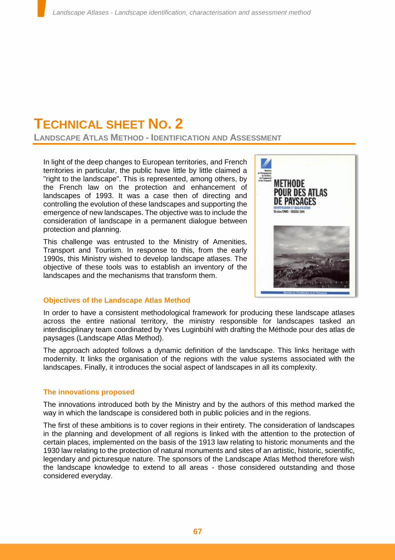
Landscape Atlases - Landscape identification, characterisation and assessment method
67
TECHNICAL SHEET NO. 2 LANDSCAPE ATLAS METHOD - IDENTIFICATION AND ASSESSMENT
In light of the deep changes to European territories, and French territories in particular, the public have little by little claimed a "right to the landscape". This is represented, among others, by the French law on the protection and enhancement of landscapes of 1993. It was a case then of directing and controlling the evolution of these landscapes and supporting the emergence of new landscapes. The objective was to include the consideration of landscape in a permanent dialogue between protection and planning.
This challenge was entrusted to the Ministry of Amenities, Transport and Tourism. In response to this, from the early 1990s, this Ministry wished to develop landscape atlases. The objective of these tools was to establish an inventory of the landscapes and the mechanisms that transform them.
Objectives of the Landscape Atlas Method
In order to have a consistent methodological framework for producing these landscape atlases across the entire national territory, the ministry responsible for landscapes tasked an interdisciplinary team coordinated by Yves Luginbühl with drafting the Méthode pour des atlas de paysages (Landscape Atlas Method).
The approach adopted follows a dynamic definition of the landscape. This links heritage with modernity. It links the organisation of the regions with the value systems associated with the landscapes. Finally, it introduces the social aspect of landscapes in all its complexity.
The innovations proposed
The innovations introduced both by the Ministry and by the authors of this method marked the way in which the landscape is considered both in public policies and in the regions.
The first of these ambitions is to cover regions in their entirety. The consideration of landscapes in the planning and development of all regions is linked with the attention to the protection of certain places, implemented on the basis of the 1913 law relating to historic monuments and the 1930 law relating to the protection of natural monuments and sites of an artistic, historic, scientific, legendary and picturesque nature. The sponsors of the Landscape Atlas Method therefore wish the landscape knowledge to extend to all areas - those considered outstanding and those considered everyday.
Landscape Atlases - Landscape identification, characterisation and assessment method
68
In this sense, this ambition pre-empted one of the important aspects of the European Landscape Convention. This effectively applies "to the entire territory of the Parties and covers natural, rural, urban and peri-urban areas. It includes land, inland water and marine areas. It concerns landscapes that might be considered outstanding as well as everyday or degraded landscapes" (art. 2).
Another important ambition of the Landscape Atlas Method is to consider the perceptible aspect of landscapes. Without the landscape being confused with a pure abstraction or dispersed into a multitude of personal assessments, the foundations of the method proposed linking the social perceptions of the areas with the tangible elements that compose them. Thus the different value systems that form the basis of landscape appreciation are revealed. They can then be considered in the methods in which the areas and the landscapes they contain are managed.
This landscape atlas method also aspires not to reserve the capacity to describe landscapes for experts alone (artists, landscape architects or scientists). With a democratic aim, the authors wish to give voice to those who construct the landscape through their decisions and practices in the territories. Thus although the 1994 method encourages artistic representations of the landscapes in the area studied to be captured, this work must be extended to include the local public's perceptions.
Landscape knowledge is therefore constructed on the basis of dialogue between the public, the decision-makers and the experts. Here again the authors of this method apply one of the key guidelines of the European Landscape Convention, which requires each signatory State "to establish procedures for the participation of the general public, local and regional authorities, and other parties with an interest in the definition and implementation of the landscape policies" (art.5).
Landscape Atlases - Landscape identification, characterisation and assessment method
69
TECHNICAL SHEET NO. 3 THE THREE PILLARS OF AN AREA'S LANDSCAPE KNOWLEDGE: FIELD OBSERVATIONS, CONSULTATION WITH STAKEHOLDERS AND OFFICE WORK
Landscape knowledge is based around three approaches: significant field work, sustained work with the local landscape stakeholders and meticulous office work. These three approaches are interdependent and necessary to the thorough understanding of an area's landscapes. These aspects must be considered upstream of the project. They determine the objectives of the approach, the resources to be mobilised and the schedule of the work to be performed.
Field observations
Field observations are primordial. Landscape is primarily perceived and understood in the field. To capture the different landscapes as they are perceived by the public, the project management must travel the area and observe its different traits. This work must be performed in situ and cannot be substituted by the use of documents, maps or remotely sensed images. Only direct observation reveals the plastic effects and variations in colours and their nuances, depths of visual field and any other sensory assessments. This field work is fundamental throughout the approach. It is used to sketch the identification and description of the landscapes in the study area and to check details of knowledge as they are produced.
It is therefore in the field in particular that the spatial organisations of the landscape structures appear. It is also in the field that the landscape variations in the study area appear and the boundaries of the landscape units are formed. Further into the approach, the boundaries of the landscape units are checked by direct observation. For the landscape units that line the study area, it is necessary to check their continuities in the neighbouring areas and therefore to travel the parts adjacent to the study area.
When updating landscape knowledge, field observations are used to check the pertinence of previous work in relation to any changes. The checking of boundaries addresses their "thickness" in particular. We know that some boundaries are sharp or, on the contrary, fuzzy, unclear, expressing transitions between two distinct landscapes that have a similar composition.
Landscape Atlases - Landscape identification, characterisation and assessment method
70
Field observations are used to initiate certain analyses which will be continued in the office or with the landscape stakeholders. They are also used to assess and check various aspects of the landscape knowledge acquired or updated as part of the approach adopted. The team responsible for the landscape knowledge of the study area must therefore demonstrate its ability to conduct field observations and provide indications regarding its availability to do so.
Consultation with landscape stakeholders
Work with the public is of great importance to the knowledge of an area's landscapes. This aspect is primordial to capturing the social representations and landscape models at play in the perception of the landscapes in the area studied – in particular the local landscape models. It is also used to gather a variety of factual information that escapes or can guide field analysis. Finally, it is used to gather a set of documents that support the analysis conducted in the office and shed light on the interpretations proposed. In addition, by consulting the landscape stakeholders, the tools for reporting the landscape knowledge they require and will have the use of can be defined. It sheds light on the organisation of the future distribution of these tools.
Work with local landscape stakeholders is therefore organised around three areas. The landscape stakeholders can provide a set of data and documents that feed and support the landscape atlas approach. They are also at the foundation of the social representations and value systems associated with landscapes and in particular everyday landscapes. Knowledge of these representations and value systems is used to assess the landscapes in the study area. Finally, the local stakeholders can decide on the pertinence of the analyses conducted and the proposed identification of the landscape units.
Field observation routes Field work must be prepared. Landscape observation covers the entire area. This can beneficially be travelled using transport routes (roads, tracks and railways) to analyse landscapes in accordance with the most used routes, namely in the same situations as the majority of potential observers. The principle of routes also presents the advantage, over a method of analysis by transects, of being more operational and quicker and therefore less costly. The routes taken obviously depend on the size of the area studied, but must enable the largest possible proportion of the area to be observed. These routes must form a sufficiently dense mesh as to avoid any observation gaps. It is important to travel these routes in several stages, so as to gain a relatively rapid overview of the entire area in the first instance and then come back to examine in greater depth the zones where the definition of the landscape units is experiencing difficulties. It is also important to travel the chosen transport routes in both directions, as landscape does not always present itself in the same way in one direction or the other. A precise choice of the transport routes and viewpoints identified must be clarified so as to be presented to the steering committee.
(In accordance with the Méthode pour des Atlas de Paysages- (Landscape Atlas Method), 1994).
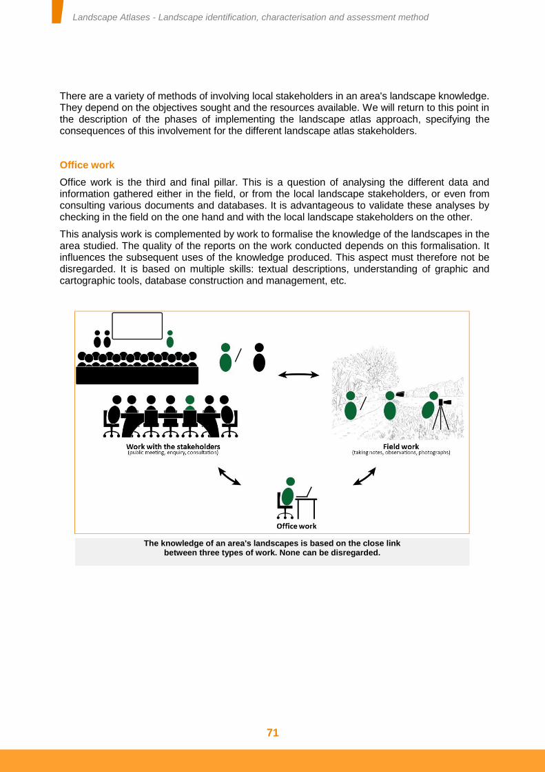
Landscape Atlases - Landscape identification, characterisation and assessment method
71
There are a variety of methods of involving local stakeholders in an area's landscape knowledge. They depend on the objectives sought and the resources available. We will return to this point in the description of the phases of implementing the landscape atlas approach, specifying the consequences of this involvement for the different landscape atlas stakeholders.
Office work
Office work is the third and final pillar. This is a question of analysing the different data and information gathered either in the field, or from the local landscape stakeholders, or even from consulting various documents and databases. It is advantageous to validate these analyses by checking in the field on the one hand and with the local landscape stakeholders on the other.
This analysis work is complemented by work to formalise the knowledge of the landscapes in the area studied. The quality of the reports on the work conducted depends on this formalisation. It influences the subsequent uses of the knowledge produced. This aspect must therefore not be disregarded. It is based on multiple skills: textual descriptions, understanding of graphic and cartographic tools, database construction and management, etc.
The knowledge of an area's landscapes is based on the close link between three types of work. None can be disregarded.
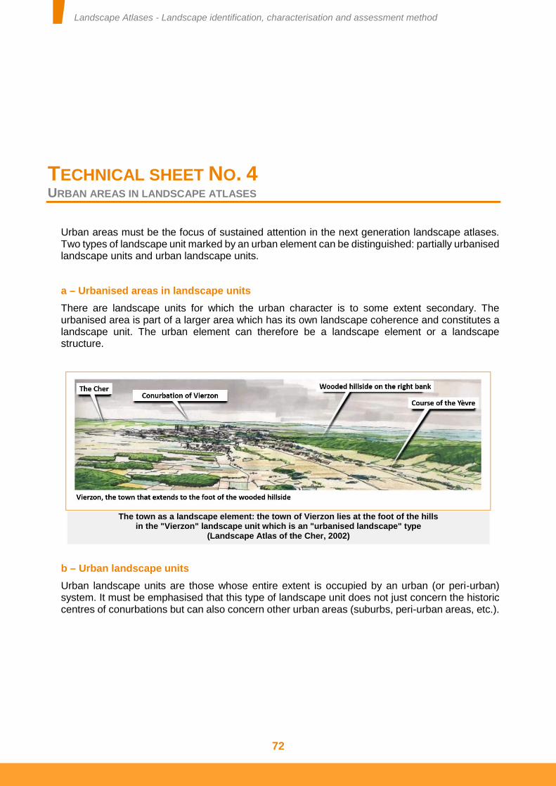
Landscape Atlases - Landscape identification, characterisation and assessment method
72
TECHNICAL SHEET NO. 4 URBAN AREAS IN LANDSCAPE ATLASES
Urban areas must be the focus of sustained attention in the next generation landscape atlases. Two types of landscape unit marked by an urban element can be distinguished: partially urbanised landscape units and urban landscape units.
a – Urbanised areas in landscape units
There are landscape units for which the urban character is to some extent secondary. The urbanised area is part of a larger area which has its own landscape coherence and constitutes a landscape unit. The urban element can therefore be a landscape element or a landscape structure.
b – Urban landscape units
Urban landscape units are those whose entire extent is occupied by an urban (or peri-urban) system. It must be emphasised that this type of landscape unit does not just concern the historic centres of conurbations but can also concern other urban areas (suburbs, peri-urban areas, etc.).
The town as a landscape element: the town of Vierzon lies at the foot of the hills in the "Vierzon" landscape unit which is an "urbanised landscape" type
(Landscape Atlas of the Cher, 2002)
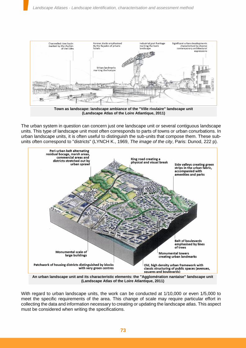
Landscape Atlases - Landscape identification, characterisation and assessment method
73
The urban system in question can concern just one landscape unit or several contiguous landscape units. This type of landscape unit most often corresponds to parts of towns or urban conurbations. In urban landscape units, it is often useful to distinguish the sub-units that compose them. These sub-units often correspond to "districts" (LYNCH K., 1969, The image of the city, Paris: Dunod, 222 p).
With regard to urban landscape units, the work can be conducted at 1/10,000 or even 1/5,000 to meet the specific requirements of the area. This change of scale may require particular effort in collecting the data and information necessary to creating or updating the landscape atlas. This aspect must be considered when writing the specifications.
Town as landscape: landscape ambiance of the "Ville rivulaire" landscape unit (Landscape Atlas of the Loire Atlantique, 2011)
An urban landscape unit and its characteristic elements: the "Agglomération nantaise" landscape unit (Landscape Atlas of the Loire Atlantique, 2011)
Landscape Atlases - Landscape identification, characterisation and assessment method
74
TECHNICAL SHEET NO. 5 CAPTURING THE SOCIAL REPRESENTATIONS OF LANDSCAPES
Numerous analyses have revealed the weight of social representations in public conflicts and expectations regarding the future of their surroundings. Capturing the social representations and value systems associated with the landscapes is therefore one of the fundamental components of landscape atlases. It relates both to the entire study area and each landscape unit. These components of landscape assessment must always be spatialised.
Experience feedback concurs in emphasising the difficulties encountered in capturing the social representations and value systems associated with landscape units. This aspect therefore warrants special attention when preparing and implementing the landscape atlas approach. A variety of methods can be implemented and invented to capture these representations using enquiries, observations, or analyses of various documents and materials.
In spite of this diversity, the approaches implemented require specific skills which cannot be improvised. They rely in particular on a disposition that allows empathy with the public and an ability to analyse social discourse. These skills are rare and must be sought, in particular, in people who have been trained in human sciences (anthropology, sociology, human geography, etc.).
Researching social representations of landscapes at study area level
An exhaustive and in-depth enquiry into the social representations and value systems associated with all of the landscapes in the study area proves costly. Research into these social representations must therefore be based on different opportunities.
The involvement of the steering committee is one of them. The members of this committee can be considered to be representatives of certain sections of the public in the area. Consulting them provides indications on the way in which the landscapes in the study area are appreciated by these sections of the public. However, this consultation must be undertaken ensuring that the members of the steering committee restrict themselves to reporting the perceptions held by the people they represent and not their own personal perceptions.
The analysis of various representations of the landscapes in the study area provides other indications. These representations can be artistic (literary, paintings, photographs, etc.), or more operational (tourist guides, regional promotional documents, post cards, etc.). The latter are often strongly inspired by the former. These documents attest to landscape archetypes that guide or have guided the social representations of the landscapes. However, some of these images are simplifications that a more in-depth analysis nuances and puts into the perspective of local landscape representations.
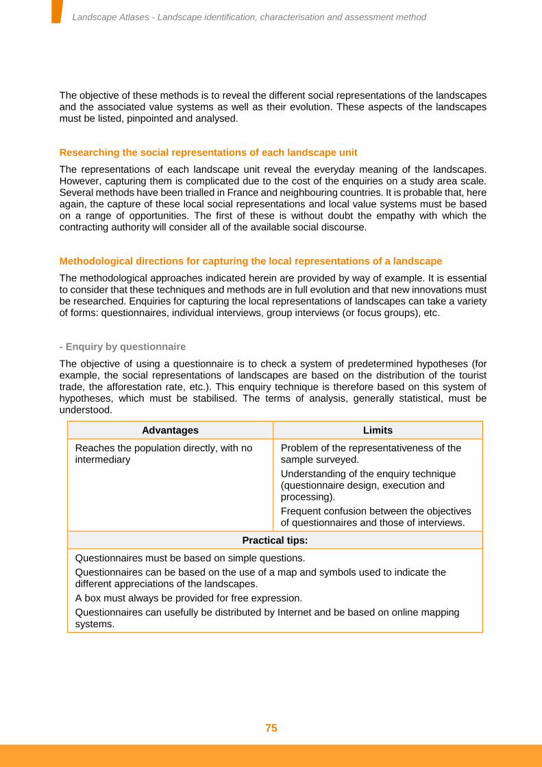
Landscape Atlases - Landscape identification, characterisation and assessment method
75
The objective of these methods is to reveal the different social representations of the landscapes and the associated value systems as well as their evolution. These aspects of the landscapes must be listed, pinpointed and analysed.
Researching the social representations of each landscape unit
The representations of each landscape unit reveal the everyday meaning of the landscapes. However, capturing them is complicated due to the cost of the enquiries on a study area scale. Several methods have been trialled in France and neighbouring countries. It is probable that, here again, the capture of these local social representations and local value systems must be based on a range of opportunities. The first of these is without doubt the empathy with which the contracting authority will consider all of the available social discourse.
Methodological directions for capturing the local representations of a landscape
The methodological approaches indicated herein are provided by way of example. It is essential to consider that these techniques and methods are in full evolution and that new innovations must be researched. Enquiries for capturing the local representations of landscapes can take a variety of forms: questionnaires, individual interviews, group interviews (or focus groups), etc.
- Enquiry by questionnaire
The objective of using a questionnaire is to check a system of predetermined hypotheses (for example, the social representations of landscapes are based on the distribution of the tourist trade, the afforestation rate, etc.). This enquiry technique is therefore based on this system of hypotheses, which must be stabilised. The terms of analysis, generally statistical, must be understood.
Advantages Limits
Reaches the population directly, with no intermediary
Problem of the representativeness of the sample surveyed.
Understanding of the enquiry technique (questionnaire design, execution and processing).
Frequent confusion between the objectives of questionnaires and those of interviews.
Practical tips:
Questionnaires must be based on simple questions.
Questionnaires can be based on the use of a map and symbols used to indicate the different appreciations of the landscapes.
A box must always be provided for free expression.
Questionnaires can usefully be distributed by Internet and be based on online mapping systems.
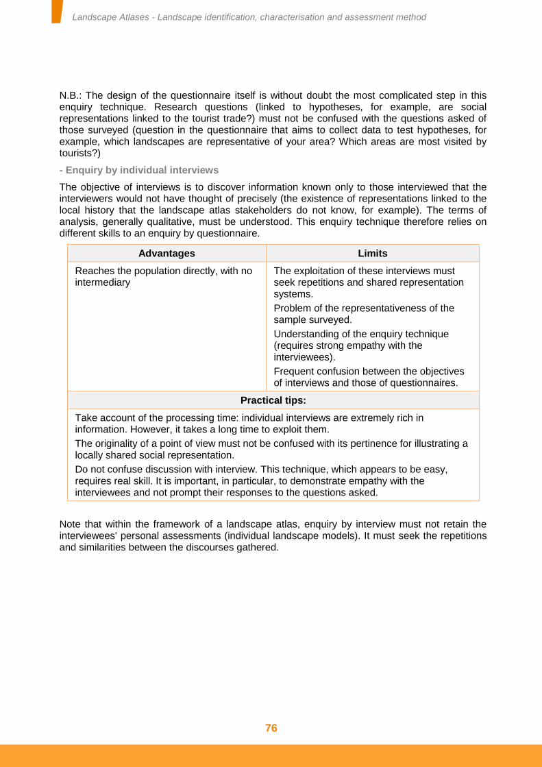
Landscape Atlases - Landscape identification, characterisation and assessment method
76
N.B.: The design of the questionnaire itself is without doubt the most complicated step in this enquiry technique. Research questions (linked to hypotheses, for example, are social representations linked to the tourist trade?) must not be confused with the questions asked of those surveyed (question in the questionnaire that aims to collect data to test hypotheses, for example, which landscapes are representative of your area? Which areas are most visited by tourists?)
- Enquiry by individual interviews
The objective of interviews is to discover information known only to those interviewed that the interviewers would not have thought of precisely (the existence of representations linked to the local history that the landscape atlas stakeholders do not know, for example). The terms of analysis, generally qualitative, must be understood. This enquiry technique therefore relies on different skills to an enquiry by questionnaire.
Advantages Limits
Reaches the population directly, with no intermediary
The exploitation of these interviews must seek repetitions and shared representation systems.
Problem of the representativeness of the sample surveyed.
Understanding of the enquiry technique (requires strong empathy with the interviewees).
Frequent confusion between the objectives of interviews and those of questionnaires.
Practical tips:
Take account of the processing time: individual interviews are extremely rich in information. However, it takes a long time to exploit them.
The originality of a point of view must not be confused with its pertinence for illustrating a locally shared social representation.
Do not confuse discussion with interview. This technique, which appears to be easy, requires real skill. It is important, in particular, to demonstrate empathy with the interviewees and not prompt their responses to the questions asked.
Note that within the framework of a landscape atlas, enquiry by interview must not retain the interviewees' personal assessments (individual landscape models). It must seek the repetitions and similarities between the discourses gathered.
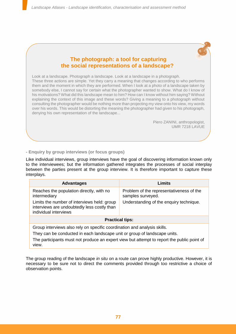
Landscape Atlases - Landscape identification, characterisation and assessment method
77
- Enquiry by group interviews (or focus groups)
Like individual interviews, group interviews have the goal of discovering information known only to the interviewees; but the information gathered integrates the processes of social interplay between the parties present at the group interview. It is therefore important to capture these interplays.
Advantages Limits
Reaches the population directly, with no intermediary
Limits the number of interviews held: group interviews are undoubtedly less costly than individual interviews
Problem of the representativeness of the samples surveyed.
Understanding of the enquiry technique.
Practical tips:
Group interviews also rely on specific coordination and analysis skills.
They can be conducted in each landscape unit or group of landscape units.
The participants must not produce an expert view but attempt to report the public point of view.
The group reading of the landscape in situ on a route can prove highly productive. However, it is necessary to be sure not to direct the comments provided through too restrictive a choice of observation points.
The photograph: a tool for capturing the social representations of a landscape?
Look at a landscape. Photograph a landscape. Look at a landscape in a photograph. These three actions are simple. Yet they carry a meaning that changes according to who performs them and the moment in which they are performed. When I look at a photo of a landscape taken by somebody else, I cannot say for certain what the photographer wanted to show. What do I know of his motivations? What did this landscape mean to him? How can I know without him saying? Without explaining the context of this image and these words? Giving a meaning to a photograph without consulting the photographer would be nothing more than projecting my view onto his view, my words over his words. This would be distorting the meaning the photographer had given to his photograph, denying his own representation of the landscape...
Piero ZANINI, anthropologist,
UMR 7218 LAVUE
Landscape Atlases - Landscape identification, characterisation and assessment method
78
- Enquiry in local territories
Each local territory (municipality, etc.) belongs to one or more landscape units. It is therefore a question of relying on the representatives of the populations of these local territories to capture the local values associated with these landscapes. This enquiry can be made of local elected representatives or town hall secretaries. It can be supported by the use of a map to locate the assessments and comments of the people questioned.
Advantages Limits
Based on the interviewees' knowledge of the municipal territory and the local populations
This enquiry is an opportunity to find out about the individual or public projects that may transform the landscapes
Number of municipalities sometimes very high
Discourse sometimes partial and not representing all of the local populations.
Practical tips:
Discuss the landscapes appreciated or disparaged by the populations with equal interest to those undergoing strong transformations.
Allow the possibility to freely express comments.
To process the enquiry's results, comment categories must be created for the landscape unit concerned.
Details of the conclusion
A large amount of data is often gathered concerning the social representations and value systems associated with each landscape unit. In addition to collecting the data, it is essential to plan the terms of its processing. This processing phase requires time and special skills. The service provider must account for this in his bid and work schedule. This phase can effectively prove to be extremely complex and time consuming, creating a sense of frustration for the different stakeholders involved in the approach to create or update the landscape atlas.
This work to capture the representations and value systems associated with the landscapes requires specific skills. However, it is important to closely link it with the work to identify and characterise the landscape units. This part of the landscape analysis is therefore neither independent of, nor incidental to the landscape atlas.
How much does it cost to capture the social representations of landscapes?
For information, several approaches of this type were estimated at between €30,000 and €60,000 (after tax) in 2013 (Departmental atlases).
Landscape Atlases - Landscape identification, characterisation and assessment method
79
TECHNICAL SHEET NO. 6 TOOLS FOR REPORTING LANDSCAPE KNOWLEDGE
Landscapes are complex subjects. It is therefore helpful to use a variety of media to report the knowledge of them: text, photographs, sketches, drawings, cross-sections, block diagrams, maps, video, etc. However, some principles must be observed so that the interpretation of the messages issued is clear and not open to controversy. The information produced can then be used for the management, protection and planning of landscapes, public surroundings and regions.
Some of the information reporting tools most commonly used in landscape atlases are presented below. This list is obviously incomplete and, according to the characteristics of the study area, the landscapes identified and the objectives for exploiting the landscape atlas, other tools must be used.
Text
The information and data contained in a landscape atlas primarily comprises text accompanied with a variety of illustrations (maps, sketches, photographs, etc.). This text is written in a rich and varied vocabulary to attest to the complexity of the landscapes and the uniqueness of each of them. However, it is advisable to use common vocabulary and simple rhetorical forms. Uncommon words must be defined in a glossary included in the appendix. Concepts specific to landscape atlases are defined in the glossary in the appendix to this document [see technical sheet No. 1].
Maps
Maps are an effective way of conveying spatial information. To facilitate the reading of the maps produced in the landscape atlases, commit to observing a few simple rules.
To allow future landscape atlas users to get their bearings in the area represented, a few key landmarks in the area must be clearly shown. The choice of these landmarks must be the same for all of the maps presented in given a landscape atlas reporting format. This permanence ensures a certain amount of uniformity between the maps and the other forms of information in the document produced.
Finally, to ensure landscape continuity between areas, it is essential to show on the maps produced the landscapes beyond the borders of the area studied (landscape continuities, boundaries between the landscape units in the study area and those in the adjacent regions).
Landscape Atlases - Landscape identification, characterisation and assessment method
80
Block diagrams
Block diagrams are used to simply represent an area in three dimensions. They present the fruit of complex analysis in a general manner. They are created by hand (drawing, sketch or outline) or digitally. This representation technique is particularly well-suited to the analysis of landscape structures. The information shown is wide-ranging and does not exclude any environments (rural, urban, etc.): relief, geologic basement (underlying strata), rhythms, sequences, range of plants, development (orientation and volume), as well as the distribution of landscape elements - data essential to characterising landscapes on the landscape unit scale.
Sometimes, particularly in zones with an accentuated relief, it may be beneficial to present an aerial photograph laid over a digital model of the terrain. However, this image is not a block diagram as it is neither general, nor the result of an analysis.
Details essential to interpreting and reusing the block diagrams must be provided: title, clear explanatory key, orientation and geographic markers.
Photographs
Taken from the ground, they are omnipresent in landscape atlases. They are used to show the areas analysed as close as possible to the ground. Aerial photographs provide an overview of the area and its components, but they are not landscape photographs and cannot substitute them or suffice for describing a landscape.
Photographs can be taken at different times and in different climatic conditions, which affects the assessment of the landscapes (snowy mountain landscapes, floods, etc.). They are also used to show the evolution to the landscape and landscape evolution mechanisms, which can be represented on digital tools by chronological slide shows of the same place. The use of photographic observatories of landscapes, whether in paper or digital format, is of particular interest. Reciprocally, the photographs taken when creating or updating a landscape atlas can serve as a basis for constructing a local photographic observatory of the landscape. It is therefore important that the photographs most characteristic of the landscape units are geolocated. It is possible to have at least one photograph per landscape unit.
A few mapping rules A few principles must be observed for all maps produced within the framework of a landscape atlas. Each map must include:
A title, which clearly states the intentions and objectives of the map, An orientation, A clear and complete key that guides the interpretation of the map, The numerical scale (fraction) at which the map has been drawn up and which indicates its accuracy, A metric scale which can be used to reveal subsequent enlargements or reductions, A reference to the data sources used to create the map, A reference to the map's creator(s), The date it was created (year).
These details must appear in an inset associated with each map produced.
Landscape Atlases - Landscape identification, characterisation and assessment method
81
In a landscape atlas, it is advisable to cover the entirety of the study area and not favour photographs of certain areas within it. In addition, so that the photographs are informative and not confined to an illustrative or aesthetic role, it is important to always provide the details essential to interpreting and reusing the photographs: a key that indicates the location, date and the photographer's name and intention.
Imported illustrations and graphic representations
Numerous illustrations necessary to a landscape atlas are taken from other documents. This is the case of post cards, old posters, tourism images, pictorial representations and extracts from documents (written passages or illustrations from books, etc.). It is also the case for productions linked to landscape planning (illustrations of Urban Development Plans (PLU), planning schemes, project visuals, etc.). However, as for photographs and maps, certain standards must always be applied: reference to the source and author of the documents, compliance with copyright, a date, title and key.
In addition to these tools, it is important to favour a diversity of types of illustration and graphic representation in a landscape atlas, provided they are of relevance to the landscape and respect the standards of use mentioned above. Within all of these reporting tools, it is important to seek overall consistency between the graphic representations.
Landscape Atlases - Landscape identification, characterisation and assessment method
82
TECHNICAL SHEET NO. 7 LANDSCAPE ATLAS EXPLOITATION FORMATS
A landscape atlas can give rise to several different types of exploitation. The format of a document (style) must not be confused with what it contains (content). However, these two aspects are linked. They must be considered in accordance with the target functions. These functions are defined by the contracting authority, assisted by the steering committee, when writing the specifications. A short review of the different exploitation formats is provided herein. It is constructed according to the objectives of exploiting the knowledge acquired in the landscape atlas approach.
To participate in promoting a region or raise public awareness of the landscape
The tools to exploit the knowledge acquired for the landscape atlas are connected to communication tools.
These tools can take the form of printed documents (books, maps, pamphlets, etc.).
Advantages Limits
Attractive document. Limited number of copies,
Printing costs,
Distribution costs.
These tools can also take the form of digital documents (Internet material whose structure has been defined upstream, facsimile versions (pdf) of printed documents, etc.).
Advantages Limits
Easily accessible to all. Less attractive than the printed document.
To be tools to support discussions between elected representatives or technical departments
The forms of exploiting the knowledge acquired for the landscape atlas must be easily accessed. These documents must avoid generalities so as to localise the aspects discussed.
Landscape Atlases - Landscape identification, characterisation and assessment method
83
These tools can take the form of printed documents (reports, printed works, maps, etc.):
Advantages Limits
Documents that can be browsed at leisure.
The aesthetics of the document must not be disregarded.
These documents must be available and distributed (cost).
Note:
Maps printed in large format (poster) can be displayed in offices and areas frequented by landscape stakeholders and viewed at leisure.
These tools can also take the form of digital documents:
Advantages Limits
Easily accessible to all of the regions' stakeholders, especially those involved in various sectoral actions.
The consultation of these documents requires an intention (which is not always present when the person is not aware of the question of the landscape).
To be tools to support decision-making by elected representatives and technical departments, or systems that provide data to research offices
The forms of exploiting the knowledge acquired for the landscape atlas must provide data in a format that can be used technically. This data must be easily accessible so it can be used effectively at the least cost. These exploitations essentially take the form of databases, information systems available on the Internet and other digital materials.
Advantages Limits
Offers clear decision-making criteria,
Facilitates the consideration of landscapes in various sectoral and regional operations.
Each criterion does not describe a landscape,
Risk of an approach by zoning or of no overall approach.
Note:
These databases are essential. However, the landscape cannot be summarised as the sum of local elements. A complex subject, it can only really be considered in the different planning or regional action operations if there is an overall approach. The landscape structures are the characteristic aspects of the landscapes that must hold the attention of the landscape and regional stakeholders. These landscape structures are based on the material and immaterial interactions that link the landscape elements. They cannot be organised in databases.
Landscape Atlases - Landscape identification, characterisation and assessment method
84
To organise the network of landscape stakeholders
To organise a network sustainably, every tool must be supported by coordination. In the case of landscape atlases, this coordination can be based on the monitoring committee.
Advantages Limits
Facilitates stakeholder interactions,
Organises a collaborative network.
Cost of the coordination (in terms of time).
A large number of other landscape atlas exploitation and knowledge distribution formats are possible. The choice of one or other of these materials depends on the objectives pursued. Although they must be produced by the landscape atlas's project management, it is important that the exploitation formats desired by the contracting authority are stated in the Special Technical Specifications.
Landscape Atlases - Landscape identification, characterisation and assessment method
85
TECHNICAL SHEET NO. 8 DATABASES AND GEOGRAPHICAL INFORMATION SYSTEMS IN LANDSCAPE ATLASES
The creation or update of a landscape atlas is the opportunity to collect and bring together all of the information on the landscapes. This information is validated locally. It is technically and scientifically reliable. To facilitate the reuse of this information and data, whenever possible the contracting authority can encourage the project management to make all of this data available. It can then be made available to the public and to all the stakeholders involved in the management, planning and protection of the landscapes.
The project management can deliver data organised such that it can easily be reused in other contexts: landscape studies on other scales, consideration of the landscape in sectoral studies, comparisons between areas, regional, cross-regional and national studies, etc. This reporting format must be simple so as to be easily reproduced. These reporting formats essentially take the form of databases and geographical information systems. They essentially concern the data that forms the basis of the landscape knowledge.
It must be emphasised that under no circumstances is this data sufficient to identify, characterise and assess a landscape. Each piece of basic data describes or addresses one aspect of the landscape and it is the combination of these aspects that is used to describe this landscape. Thus to take landscapes into consideration in different regional operations, this data must be expanded, in particular with landscape structures, and interpreted by landscape specialists. The organisation of this basic data must therefore allow the user to easily link the data to the summary document presenting the identification, assessment and characterisation of the landscapes in the study area. This link can be assured thanks to the perimeter of the landscape units.
Constructing landscape databases
There is a set of localised data which, although it cannot be used to describe the full complexity of landscapes, can be used to inform the spatial distribution of certain aspects of these landscapes. Because it refers to wide categories of stabilised information, it can easily be reused. This data can be delivered to the contracting authority as the final data of the landscape atlas.
With a pragmatic concern, a simple scope of basic data that can be entered in a geographical information system can be defined. This data concerns the identification of landscapes, certain details that describe the landscapes and certain aspects of the assessment of the landscapes, without exhausting these three aspects of landscape atlases.
Landscape Atlases - Landscape identification, characterisation and assessment method
86
Thus the data on the landscapes that could be formalised and stored in easily interoperable geographic databases could be:
The perimeters of landscape units. This partition of the entire region into a grid which is meaningful in terms of landscape is an opportunity to stabilise the knowledge of landscapes, compare views and exchange experiences. A range of data can be projected onto this grid. Fuzzy boundaries or landscapes that form a transition between two landscape units must appear as a specific polygon. Thus the transition between landscape unit LU1 and landscape unit LU22 will be transition zone LU1-22
The location of different landscape elements. A reference list of the different categories of landscape element can be drawn up. This could include:
- isolated landscape elements, entered into a localised database in the form of points,
- landscape elements that contribute to landscape structures, entered into a localised database in the form of polygons (areas in which these elements are present).
The perimeters of areas considered outstanding due to their landscapes. A reference list of the areas considered outstanding due to their landscapes can be drawn up. This will include listed and classified sites, Architectural, Urban and Landscape Heritage Protection Zones (ZPPAUP) and Architecture and Heritage Enhancement Areas (AVAP), UNESCO world heritage sites, Great Sight-Seeing Operations, etc. This section should be divided into two sub-sections to distinguish:
- the perimeters of temporary organisations (Great Sight-Seeing Operations, etc.),
- the perimeters of more sustainable areas considered to be outstanding due to their landscapes (UNESCO world heritage sites, etc.).
The perimeters of areas subject to landscape planning projects (the landscape as a subject of sectoral policy) and the perimeters of areas in which landscape quality objectives are explicitly formulated (the landscape as a subject of cross-disciplinary policy), for everyday landscapes and landscapes considered outstanding. These concern the perimeters of landscape plans, for example.
The construction of these landscape databases can be based on existing databases. However, this phase of creating or updating a landscape atlas cannot be confused with a simple compilation of these existing databases. In effect, attention must be paid to the landscape relevance of each element in these databases. For example, some elements of historic heritage are landscape elements, others are not. Likewise, attention must be paid to the choice of a database in which every element is referenced. For example, some listed or classified sites are landscape elements on the working scale of landscape atlases, whilst others are perimeters of the regions considered outstanding due to their landscapes. The decision to include a given element in the different databases mentioned above must be made as close as possible to the ground. It will be proposed by the project management and validated by the contracting authority on the advice of the steering committee.
The organisation proposed must allow subsequent technical or organisational evolutions to be integrated into the construction of interoperable information systems. The foundation of this interoperability remains the simple formalisation of this data on the landscapes and its geolocation in computer databases.
Landscape Atlases - Landscape identification, characterisation and assessment method
87
The geometry of GIS files must avoid overlaps between polygons of the same category, including those relating to transition zones (for the landscape units in particular). For these files to be compatible, it is recommended to avoid the use of accents and special characters for the text attributes.
Localised iconographic databases
We propose associating a local iconographic database with this data, containing all the photographs, maps, block diagrams, sketches, etc. that are royalty free or were acquired during the production of the landscape atlas. The format of illustrations and photographs to be favoured is a .jpg type format at its maximum quality (with a minimum resolution of 300DPI for a width of 15 cm). The format of drawings and all other reproductions (facsimiles) to be favoured is .pdf type (with a minimum resolution of 300DPI).
The specification of data must appear in the Special Technical Specifications. However, the databases provided must allow all of the elements they contain to be geolocated (format compatible with a GIS).
Each of these pieces of data must be accompanied with metadata enabling the user to date and locate them (in the case of localisable data) and obtain information on their authors. The specification of this metadata must appear in the Special Technical Specifications.
The landscape atlas's project management will deliver this data and metadata to the contracting authority. The contracting authority will include this workload in the Special Technical Specifications for the call for tenders and ensure it has been performed correctly when reported.

Landscape Atlases - Landscape identification, characterisation and assessment method
88
TECHNICAL SHEET NO. 9 PROPOSED TEXT FOR THE SPECIAL TECHNICAL SPECIFICATIONS FOR CONTRACTS TO
CREATE OR UPDATE A LANDSCAPE ATLAS
This proposal must, in all cases, be assessed and approved by the contracting authority of the contract to create or update a landscape atlas. This simple proposal must be adapted to the regulatory and regional contexts in which the contract is awarded.
Arrangements for intellectual property rights and rights of whatever nature - Transfer of landscape atlas exploitation rights
Purpose of the transfer
The transfer pertains the results relating to the services provided as part of this contract concerning the creation or update of a landscape atlas, to all of the data and information produced in the approach adopted to create or update the landscape atlas and necessary to constructing the results of this approach, as well as to the conclusions, notes, reports and other items required as part of this contract.
The contract holder transfers, on an exclusive basis, all of the rights of whatever nature pertaining to all of the results, data and information described above, allowing the contracting authority to freely exploit them to ensure the promotion and distribution of the landscape knowledge and its consideration in all actions or planning operations contributing to the management, planning or protection of landscapes.
The rights thus transferred are the rights of reproduction, representation, arrangement, correction, adaptation, translation, communication and distribution for the entire world and for a duration of 70 years.
The results will be subject to:
distribution via the public body's internal network, which will allow free consultation by the departments of the public body,
distribution to the public via the Internet; they will be accessible on the public body's website, which will allow free consultation by all members of the public with the possibility of downloading and printing pages and images,

Landscape Atlases - Landscape identification, characterisation and assessment method
89
availability in the form of paper materials and copies on CD-Rom, DVD-Rom or any other file storage medium,
availability to press, media and publishing departments in the form of copies on CD-Rom, DVD-Rom or any other file storage medium, for promotional and distribution purposes.
The price of this transfer is included in the contract price. The contract holder will not be able to claim any additional sum for any reason whatsoever.
Contract holder rights and obligations
The contract holder cannot publish the results.
The contract holder maintains his own rights, including those of exploitation, relating to the prior knowledge incorporated in the results.
In the event of publication or communication, the public body undertakes to mention the name and quality of the author of the landscape atlas or of each of the pieces of information contained in the landscape atlas and each reproduction thereof.
The contracting authority to whom the rights were transferred can retrocede the exploitation rights to the contract holder on a non-exclusive basis.
The contract holder must respect the right of personal portrayal of the people liable to be photographed. He shall be responsible for obtaining the authorisations necessary to respecting the right of personal portrayal of the people and the rights of authors of original works (buildings, artistic works, etc.) that may be photographed and indemnify the public body against any third party claims.
Prior knowledge arrangements
The conclusion of the contract does not include the transfer of intellectual property rights or of rights of any nature pertaining to prior knowledge. The contracting authority and the third parties appointed by the contract holder remain holders, each as regards the matters that concern them, of the intellectual property rights or rights of any nature relating to prior knowledge.
The contract holder remains proprietor of his method, tools, know-how and documentation that constitute his prior knowledge used to execute the contract. However, the contract holder transfers to the public body the prior knowledge of which he was proprietor and which has been used for the execution of the contract for the full duration of the rights of use relating to the results which are the subject of the contract. The contract holder's prior knowledge must be able to be listed as the landscape atlas is created or updated.
Within this context, the public body benefits from the transfer of the rights of use, adaptation and modification through improvement, corrections simplifications, addition and integration in existing or future works.
The transfer of rights to prior knowledge is included in the contract price. The rights are transferred for the duration of the rights of use pertaining to the results.
Landscape Atlases - Landscape identification, characterisation and assessment method
90
Landscape Atlases - Landscape identification, characterisation and assessment method
91
Appendices
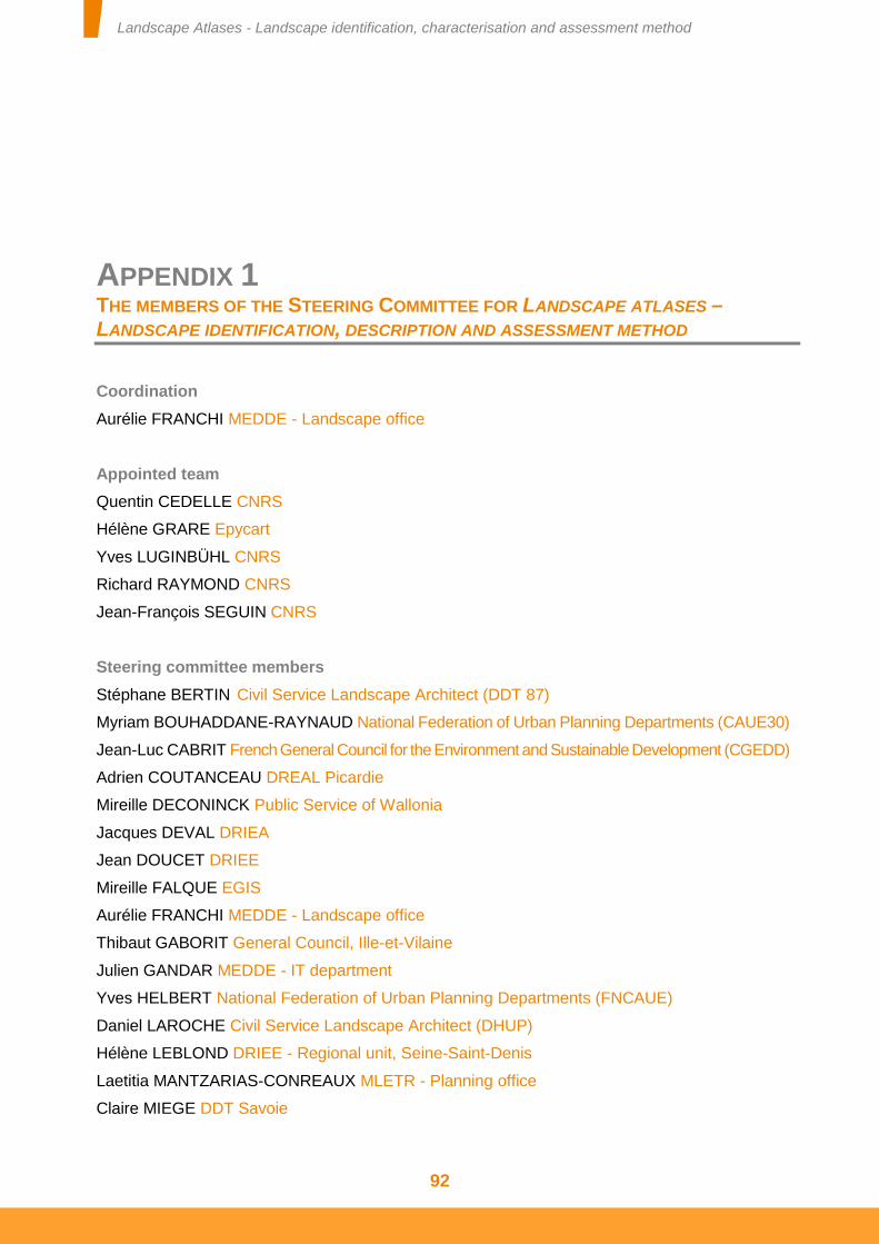
Landscape Atlases - Landscape identification, characterisation and assessment method
92
APPENDIX 1 THE MEMBERS OF THE STEERING COMMITTEE FOR LANDSCAPE ATLASES –
LANDSCAPE IDENTIFICATION, DESCRIPTION AND ASSESSMENT METHOD
Coordination
Aurélie FRANCHI MEDDE - Landscape office
Appointed team
Quentin CEDELLE CNRS
Hélène GRARE Epycart
Yves LUGINBÜHL CNRS
Richard RAYMOND CNRS
Jean-François SEGUIN CNRS
Steering committee members
Stéphane BERTIN Civil Service Landscape Architect (DDT 87)
Myriam BOUHADDANE-RAYNAUD National Federation of Urban Planning Departments (CAUE30)
Jean-Luc CABRIT French General Council for the Environment and Sustainable Development (CGEDD)
Adrien COUTANCEAU DREAL Picardie
Mireille DECONINCK Public Service of Wallonia
Jacques DEVAL DRIEA
Jean DOUCET DRIEE
Mireille FALQUE EGIS
Aurélie FRANCHI MEDDE - Landscape office
Thibaut GABORIT General Council, Ille-et-Vilaine
Julien GANDAR MEDDE - IT department
Yves HELBERT National Federation of Urban Planning Departments (FNCAUE)
Daniel LAROCHE Civil Service Landscape Architect (DHUP)
Hélène LEBLOND DRIEE - Regional unit, Seine-Saint-Denis
Laetitia MANTZARIAS-CONREAUX MLETR - Planning office
Claire MIEGE DDT Savoie
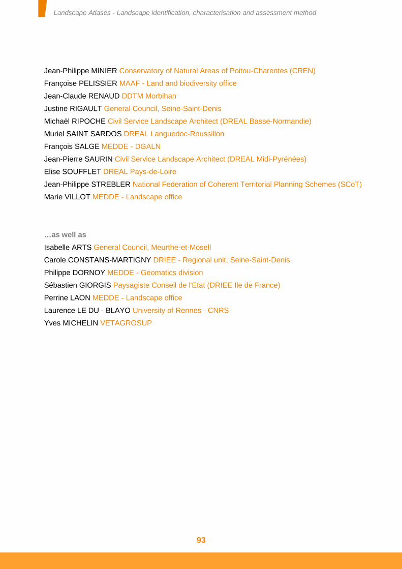
Landscape Atlases - Landscape identification, characterisation and assessment method
93
Jean-Philippe MINIER Conservatory of Natural Areas of Poitou-Charentes (CREN)
Françoise PELISSIER MAAF - Land and biodiversity office
Jean-Claude RENAUD DDTM Morbihan
Justine RIGAULT General Council, Seine-Saint-Denis
Michaël RIPOCHE Civil Service Landscape Architect (DREAL Basse-Normandie)
Muriel SAINT SARDOS DREAL Languedoc-Roussillon
François SALGE MEDDE - DGALN
Jean-Pierre SAURIN Civil Service Landscape Architect (DREAL Midi-Pyrénées)
Elise SOUFFLET DREAL Pays-de-Loire
Jean-Philippe STREBLER National Federation of Coherent Territorial Planning Schemes (SCoT)
Marie VILLOT MEDDE - Landscape office
…as well as
Isabelle ARTS General Council, Meurthe-et-Mosell
Carole CONSTANS-MARTIGNY DRIEE - Regional unit, Seine-Saint-Denis
Philippe DORNOY MEDDE - Geomatics division
Sébastien GIORGIS Paysagiste Conseil de l'Etat (DRIEE Ile de France)
Perrine LAON MEDDE - Landscape office
Laurence LE DU - BLAYO University of Rennes - CNRS
Yves MICHELIN VETAGROSUP
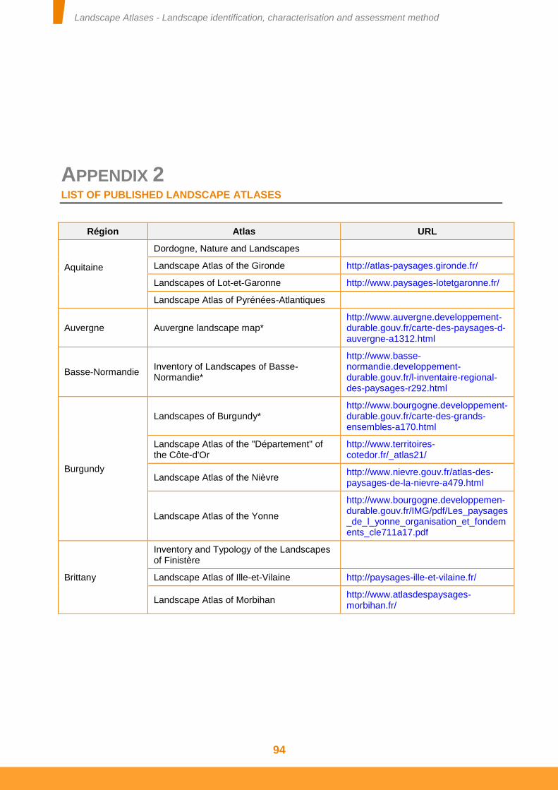
Landscape Atlases - Landscape identification, characterisation and assessment method
94
APPENDIX 2 LIST OF PUBLISHED LANDSCAPE ATLASES
Région Atlas URL
Aquitaine
Dordogne, Nature and Landscapes
Landscape Atlas of the Gironde http://atlas-paysages.gironde.fr/
Landscapes of Lot-et-Garonne http://www.paysages-lotetgaronne.fr/
Landscape Atlas of Pyrénées-Atlantiques
Auvergne Auvergne landscape map* http://www.auvergne.developpement-durable.gouv.fr/carte-des-paysages-d-auvergne-a1312.html
Basse-Normandie Inventory of Landscapes of Basse-Normandie*
http://www.basse-normandie.developpement-durable.gouv.fr/l-inventaire-regional-des-paysages-r292.html
Burgundy
Landscapes of Burgundy* http://www.bourgogne.developpement-durable.gouv.fr/carte-des-grands-ensembles-a170.html
Landscape Atlas of the "Département" of the Côte-d'Or
http://www.territoires-cotedor.fr/_atlas21/
Landscape Atlas of the Nièvre http://www.nievre.gouv.fr/atlas-des-paysages-de-la-nievre-a479.html
Landscape Atlas of the Yonne
http://www.bourgogne.developpemen-durable.gouv.fr/IMG/pdf/Les_paysages_de_l_yonne_organisation_et_fondements_cle711a17.pdf
Brittany
Inventory and Typology of the Landscapes of Finistère
Landscape Atlas of Ille-et-Vilaine http://paysages-ille-et-vilaine.fr/
Landscape Atlas of Morbihan http://www.atlasdespaysages-morbihan.fr/
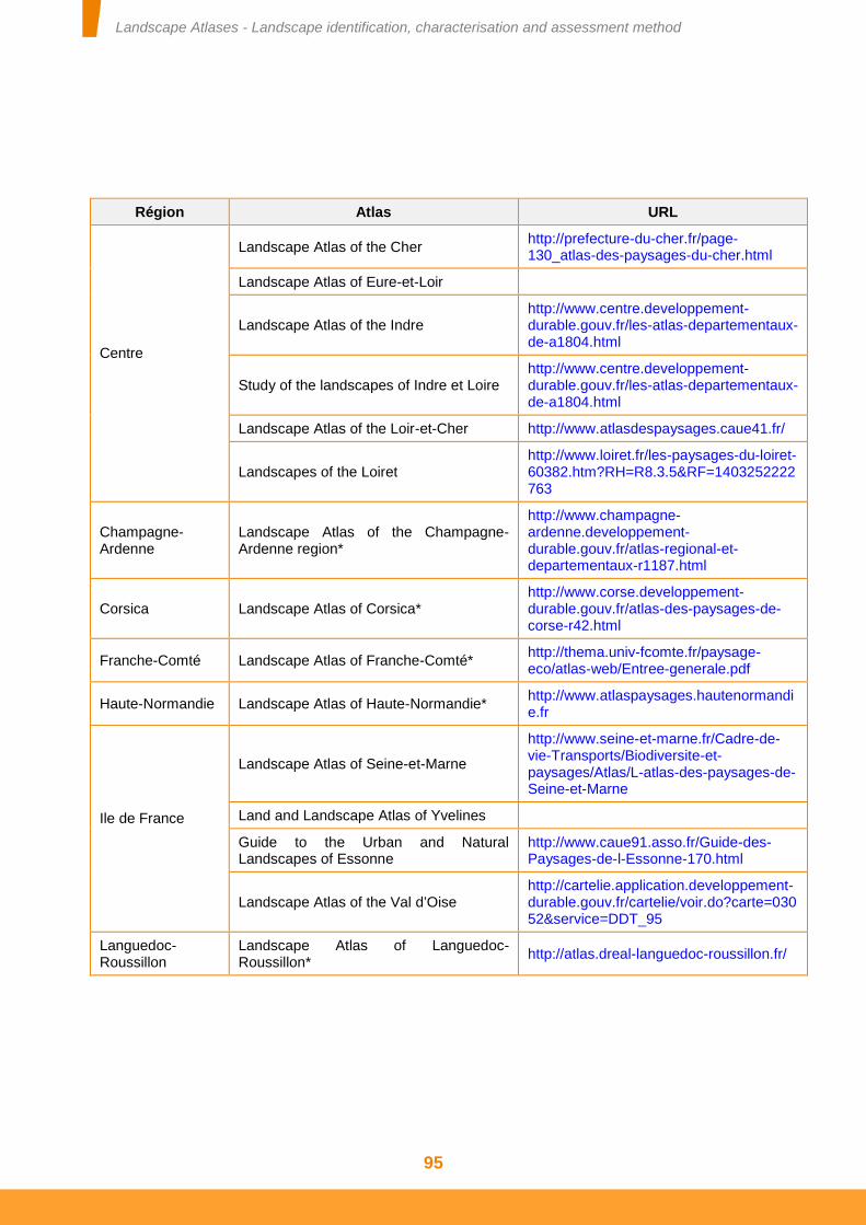
Landscape Atlases - Landscape identification, characterisation and assessment method
95
Région Atlas URL
Centre
Landscape Atlas of the Cher http://prefecture-du-cher.fr/page-130_atlas-des-paysages-du-cher.html
Landscape Atlas of Eure-et-Loir
Landscape Atlas of the Indre http://www.centre.developpement-durable.gouv.fr/les-atlas-departementaux-de-a1804.html
Study of the landscapes of Indre et Loire http://www.centre.developpement-durable.gouv.fr/les-atlas-departementaux-de-a1804.html
Landscape Atlas of the Loir-et-Cher http://www.atlasdespaysages.caue41.fr/
Landscapes of the Loiret http://www.loiret.fr/les-paysages-du-loiret-60382.htm?RH=R8.3.5&RF=1403252222763
Champagne-Ardenne
Landscape Atlas of the Champagne-Ardenne region*
http://www.champagne-ardenne.developpement-durable.gouv.fr/atlas-regional-et-departementaux-r1187.html
Corsica Landscape Atlas of Corsica* http://www.corse.developpement-durable.gouv.fr/atlas-des-paysages-de-corse-r42.html
Franche-Comté Landscape Atlas of Franche-Comté* http://thema.univ-fcomte.fr/paysage-eco/atlas-web/Entree-generale.pdf
Haute-Normandie Landscape Atlas of Haute-Normandie* http://www.atlaspaysages.hautenormandie.fr
Ile de France
Landscape Atlas of Seine-et-Marne
http://www.seine-et-marne.fr/Cadre-de-vie-Transports/Biodiversite-et-paysages/Atlas/L-atlas-des-paysages-de-Seine-et-Marne
Land and Landscape Atlas of Yvelines
Guide to the Urban and Natural Landscapes of Essonne
http://www.caue91.asso.fr/Guide-des-Paysages-de-l-Essonne-170.html
Landscape Atlas of the Val d’Oise http://cartelie.application.developpement-durable.gouv.fr/cartelie/voir.do?carte=03052&service=DDT_95
Languedoc-Roussillon
Landscape Atlas of Languedoc-Roussillon*
http://atlas.dreal-languedoc-roussillon.fr/
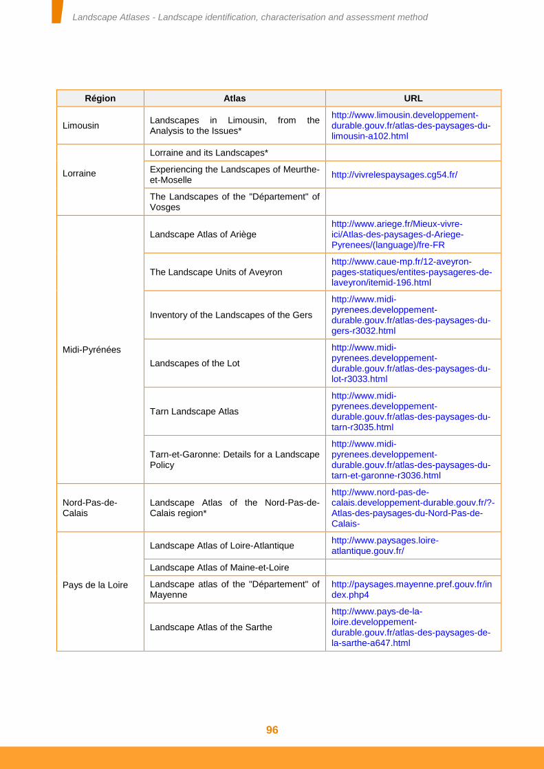
Landscape Atlases - Landscape identification, characterisation and assessment method
96
Région Atlas URL
Limousin Landscapes in Limousin, from the Analysis to the Issues*
http://www.limousin.developpement-durable.gouv.fr/atlas-des-paysages-du-limousin-a102.html
Lorraine
Lorraine and its Landscapes*
Experiencing the Landscapes of Meurthe-et-Moselle
http://vivrelespaysages.cg54.fr/
The Landscapes of the "Département" of Vosges
Midi-Pyrénées
Landscape Atlas of Ariège http://www.ariege.fr/Mieux-vivre-ici/Atlas-des-paysages-d-Ariege-Pyrenees/(language)/fre-FR
The Landscape Units of Aveyron http://www.caue-mp.fr/12-aveyron-pages-statiques/entites-paysageres-de-laveyron/itemid-196.html
Inventory of the Landscapes of the Gers
http://www.midi-pyrenees.developpement-durable.gouv.fr/atlas-des-paysages-du-gers-r3032.html
Landscapes of the Lot
http://www.midi-pyrenees.developpement-durable.gouv.fr/atlas-des-paysages-du-lot-r3033.html
Tarn Landscape Atlas
http://www.midi-pyrenees.developpement-durable.gouv.fr/atlas-des-paysages-du-tarn-r3035.html
Tarn-et-Garonne: Details for a Landscape Policy
http://www.midi-pyrenees.developpement-durable.gouv.fr/atlas-des-paysages-du-tarn-et-garonne-r3036.html
Nord-Pas-de-Calais
Landscape Atlas of the Nord-Pas-de-Calais region*
http://www.nord-pas-de-calais.developpement-durable.gouv.fr/?-Atlas-des-paysages-du-Nord-Pas-de-Calais-
Pays de la Loire
Landscape Atlas of Loire-Atlantique http://www.paysages.loire-atlantique.gouv.fr/
Landscape Atlas of Maine-et-Loire
Landscape atlas of the "Département" of Mayenne
http://paysages.mayenne.pref.gouv.fr/index.php4
Landscape Atlas of the Sarthe
http://www.pays-de-la-loire.developpement-durable.gouv.fr/atlas-des-paysages-de-la-sarthe-a647.html
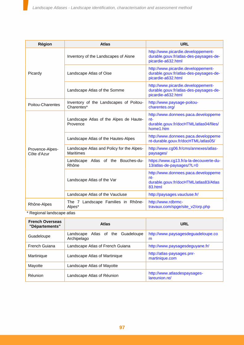
Landscape Atlases - Landscape identification, characterisation and assessment method
97
Région Atlas URL
Picardy
Inventory of the Landscapes of Aisne http://www.picardie.developpement-durable.gouv.fr/atlas-des-paysages-de-picardie-a632.html
Landscape Atlas of Oise http://www.picardie.developpement-durable.gouv.fr/atlas-des-paysages-de-picardie-a632.html
Landscape Atlas of the Somme http://www.picardie.developpement-durable.gouv.fr/atlas-des-paysages-de-picardie-a632.html
Poitou-Charentes Inventory of the Landscapes of Poitou-Charentes*
http://www.paysage-poitou-charentes.org/
Provence-Alpes-Côte d'Azur
Landscape Atlas of the Alpes de Haute-Provence
http://www.donnees.paca.developpement-durable.gouv.fr/docHTML/atlas04/files/home1.htm
Landscape Atlas of the Hautes-Alpes http://www.donnees.paca.developpement-durable.gouv.fr/docHTML/atlas05/
Landscape Atlas and Policy for the Alpes-Maritimes
http://www.cg06.fr/cms/annexes/atlas-paysages/
Landscape Atlas of the Bouches-du-Rhône
https://www.cg13.fr/a-la-decouverte-du-13/atlas-de-paysages/?L=0
Landscape Atlas of the Var
http://www.donnees.paca.developpement-durable.gouv.fr/docHTML/atlas83/Atlas83.html
Landscape Atlas of the Vaucluse http://paysages.vaucluse.fr/
Rhône-Alpes The 7 Landscape Families in Rhône-Alpes*
http://www.rdbrmc-travaux.com/spge/site_v2/orp.php
* Regional landscape atlas
French Overseas "Départements"
Atlas URL
Guadeloupe Landscape Atlas of the Guadeloupe Archipelago
http://www.paysagesdeguadeloupe.com
French Guiana Landscape Atlas of French Guiana http://www.paysagesdeguyane.fr/
Martinique Landscape Atlas of Martinique http://atlas-paysages.pnr-martinique.com
Mayotte Landscape Atlas of Mayotte
Réunion Landscape Atlas of Réunion http://www.atlasdespaysages-lareunion.re/
Landscape Atlases - Landscape identification, characterisation and assessment method
98
APPENDIX 3 TENDER FOR INTERNET PUBLICATION OF A LANDSCAPE ATLAS
Description
This tender allows the beneficiaries to exploit a landscape atlas on a website.
This service allows:
Textual content, images, sounds, videos (in flash video format), documents (possibly browsable) and geographic maps to be published.
The publication of information by all to be facilitated:
- ready-to-use websites with a "neutral" graphic charter, to concentrate on the content by being freed from technical and graphic concerns,
- a simplified interface for entering articles from the public part of the websites (following authentication and according to the rights on the site),
- organised support deployed to all departments (training and assistance).
Content published on the site to be searched.
The service includes:
- The provision of a ready-to-use website and an administrator account.
- Centralised, secure and maintained hosting of this website.
- The site includes numerous page templates enabling the formatting to be adapted to the content to be published (around 18 article formats, 25 header formats, multiple shortcuts to add to a homepage, etc.), (see the attached examples: geological map display and photo library display).
- The possibility of inserting attachments of up to 25 Mb on the pages.
- Training and support for the webmasters and the coordination of a national network.
- A national and local training space, teaching software and a sandbox (test site) accessible on the State's network.
Landscape Atlases - Landscape identification, characterisation and assessment method
99
This service does not include:
- Training and support for the writers and restricted administrators (administrators of part of a site): this training and support are provided locally by the webmaster.
- Write access to the servers: the website is updated via an input interface accessible on an Internet browser.
- Update access via the website's URL: updates are made via a special management address, in principle on the Intranet but which can be accessible on the Internet.
- The addition of features specific to a site; only features that can apply across all sites are studied.
Beneficiary(s)
The sponsors of a landscape atlas (generally the DREAL (Regional Directorate for the Environment, Development and Housing), DDT (Departmental territorial directorates), General Council and Regional Councils). When the atlas project is based on a partnership with an authority, sponsorship by a DDT, prefecture or DREAL is required.
Access terms and conditions
Place the request via a State department eligible for the web publication tender (DREAL, DDT, or prefecture where applicable), who will be the single point of contact for the operators of the web publication tender throughout the tender's period of operation. If the site is published as a State website (.gouv.fr), it must comply with the State's Internet charter (http://references.modernisation.gouv.fr/charte-internet-de-letat).It must, for example, be the subject of a request for prior approval.
Involve a webmaster from the eligible State department.
Have the latter follow the procedure for requesting the creation of the site published on the web department site: http://web.metier.i2/comment-demander-l-ouverture-d-un-a107.html
Support the site's webmaster with GISEH (hypertext editorial system information management) training (site administrator).
Supplier commitments
The service is available 24/7. However, a guaranteed service resumption time of 4 hours only applies to working hours (Monday to Friday, excluding public holidays, from 6 am to 8 pm).
A site is created in 10 working days, unless content is recovered.
Support and assistance
The first level assistance to the writers is provided by the webmasters. Information documents are available on the web department Intranet site: http://web.metier.i2/publication-web-giseh-r14.html.
The second level assistance is intended for the webmasters and is provided by the national web expert division (PNE web). It is obtained by sending a message to the working mailbox: [email protected].
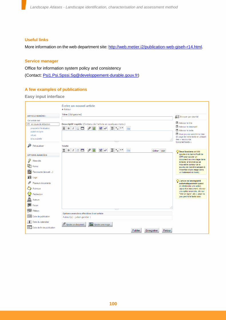
Landscape Atlases - Landscape identification, characterisation and assessment method
100
Useful links
More information on the web department site: http://web.metier.i2/publication-web-giseh-r14.html.
Service manager
Office for information system policy and consistency
(Contact: [email protected])
A few examples of publications
Easy input interface
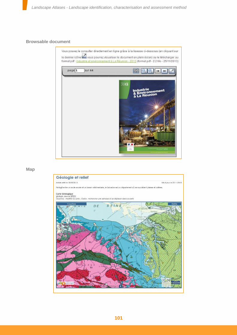
Landscape Atlases - Landscape identification, characterisation and assessment method
101
Browsable document
Map
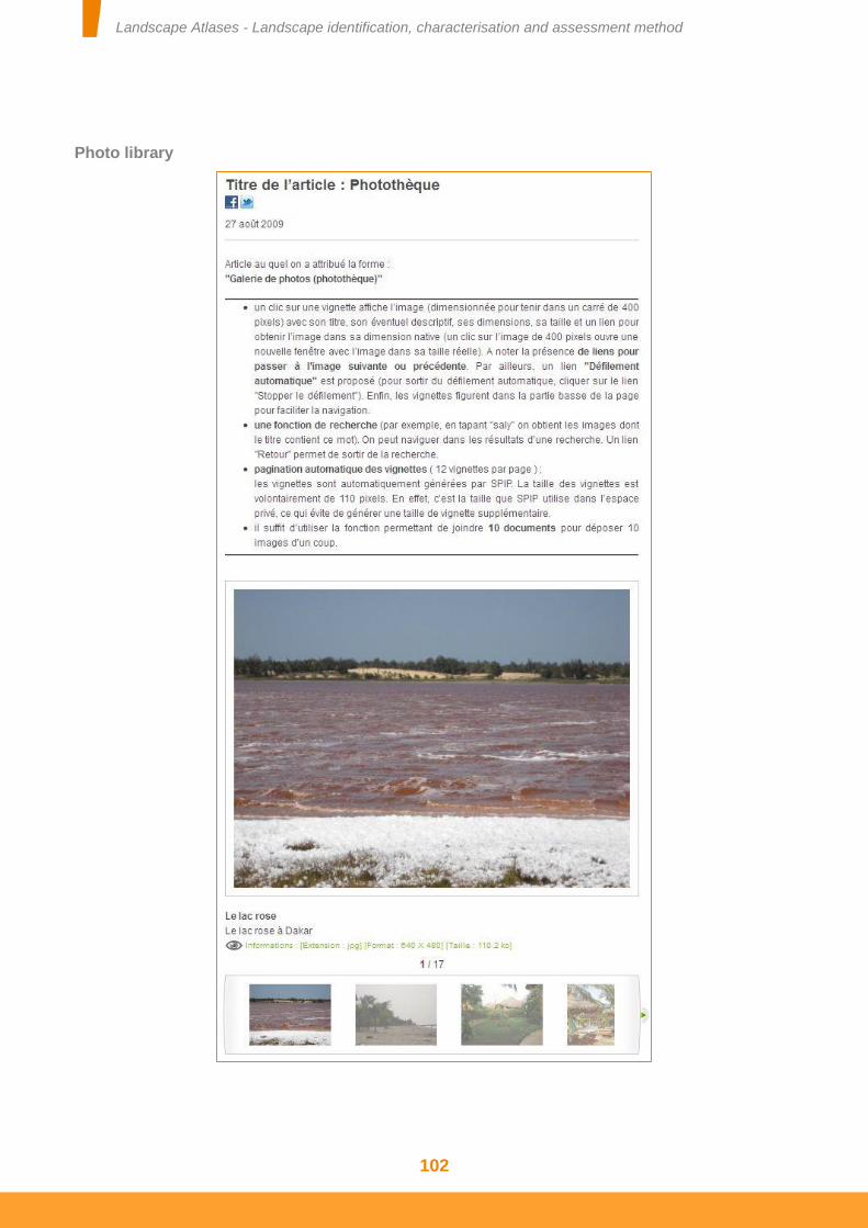
Landscape Atlases - Landscape identification, characterisation and assessment method
102
Photo library
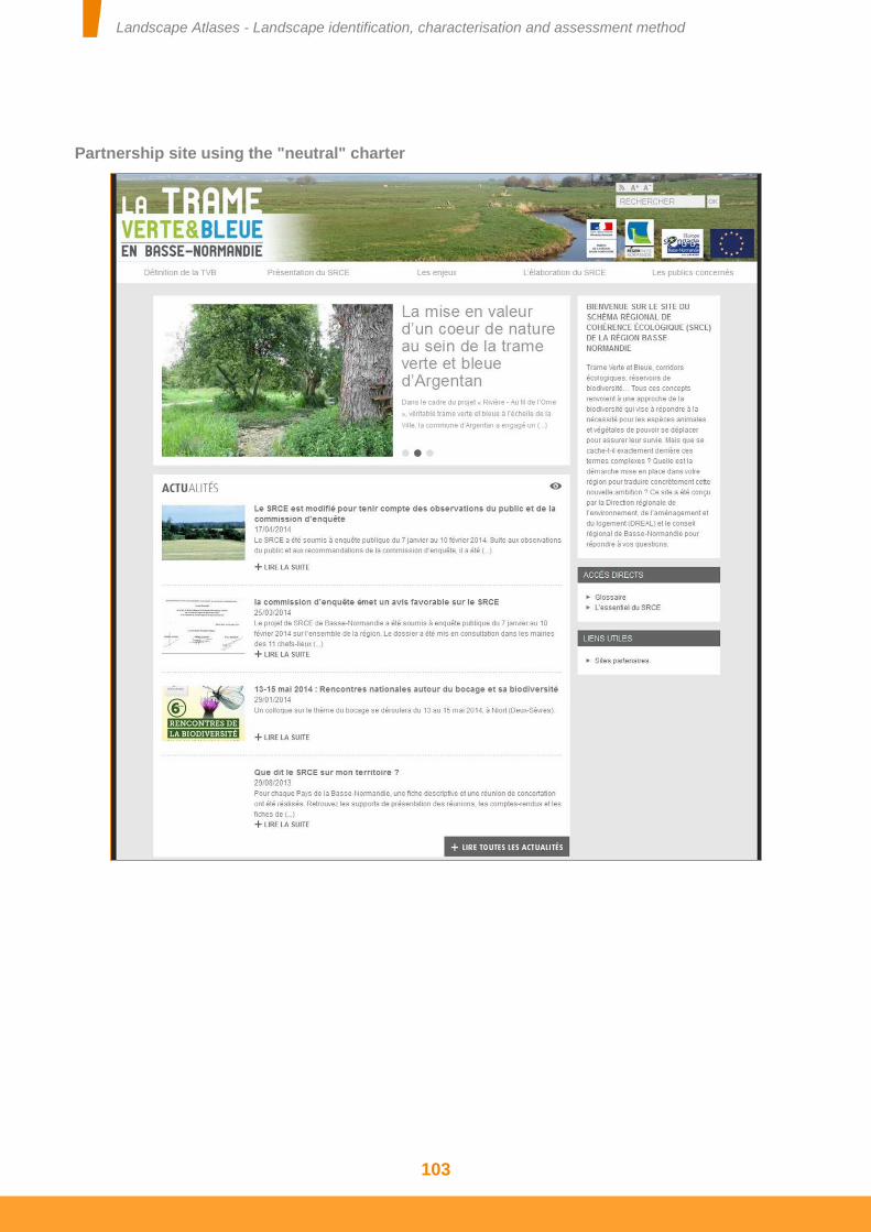
Landscape Atlases - Landscape identification, characterisation and assessment method
103
Partnership site using the "neutral" charter
Landscape Atlases - Landscape identification, characterisation and assessment method
104
APPENDIX 4 TENDER FOR CARTOGRAPHIC PUBLICATION FOR A LANDSCAPE ATLAS
Description
This tender is based on the Ministry of Ecology's internal tender to its own departments and to the departmental territorial directorates (DDT). It therefore requires the participation and prior agreement of a department of the Ministry. Its longevity is identical to that of the Ministry's internal tender, itself subject to legal obligations relating to publication.
It allows the Regional Directorates for the Environment, Development and Housing (DREAL) or DDT to complement the standard Internet publication (Information management using hypertext editing system, for example) of a landscape atlas.
This service allows :
Publication on the Internet of the atlas's “GIS” maps, i.e. those created with GIS tools such as QGIS, ArcGIS or Mapinfo (e.g. location of outstanding points, zonings, etc. based on IGN (French National Institute of Geographic and Forest Information) maps or photos), in accordance with the standards stipulated by the Inspire directive, which does not apply to landscape atlases but constitutes the main technical reference for cartographic publication;
All users (whether or not GIS specialists) to be offered a cartographic means of displaying the atlas's “GIS” maps, accessible via a link from the atlas's main website;
GIS specialists and informed users to be offered:
- an additional means of discovering an atlas's “GIS” maps thanks to the search engine in Inspire catalogues, in particular in the National Geocatalogue operated by the French Geological Survey (BRGM) (http://geocatalogue.fr);
- a means of downloading from the Geocatalogue “GIS” cartographic data relating to the map published in the atlas.
The service includes:
- The use of the Ministry of Ecology's Inspire-compatible cartographic publication platform known as “Géo-IDE Cartographie”
- The centralised, secure and maintained hosting of this platform
This service does not include:
- Training and support for data administrators and geomaticians other than those at the Ministry of Ecology and the DDT.
Landscape Atlases - Landscape identification, characterisation and assessment method
105
Beneficiary(s)
The landscape atlas sponsors (generally DREAL, DDT, General Councils and Regional Councils). When the sponsor is not a department of the Ministry of Ecology or a DDT, the atlas project must be based on a partnership that must include a department of the Ministry of Ecology or a DDT.
Acces terms ans conditions
For an entity that is neither a department of the Ministry of Ecology, nor a DDT, the request is to be transmitted to the atlas's partner, Ministry department or DDT whose localised data administrator will be the single point of contact for the operators of the national publication platform throughout the tender's operation period. The maps will be published with a State Internet address (.gouv.fr).
Suppliers commitments
Once live, the service is available 24/7. However, a guaranteed service resumption time of 4 hours only applies to working hours (Monday to Friday, excluding public holidays, from 6 am to 8 pm).
Support and assistance
First level assistance is provided by the data administrator of the department at the Ministry of Ecology or DDT that proceeded with the publication.
Second level assistance is reserved for this data administrator.
Userfullinks
More information on the geoinformation department website:
http://www.geoinformations.developpement-durable.gouv.fr/presentation-r889.html
Keywords
Géo-IDE, Géo-IDE Cartographie, Internet, Landscape atlas
Service manager
Office for information system policy and consistency
(Contact: [email protected])
Sheet revision date
January 2015
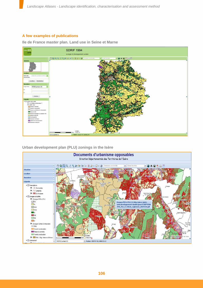
Landscape Atlases - Landscape identification, characterisation and assessment method
106
A few examples of publications
Ile de France master plan. Land use in Seine et Marne
Urban development plan (PLU) zonings in the Isère
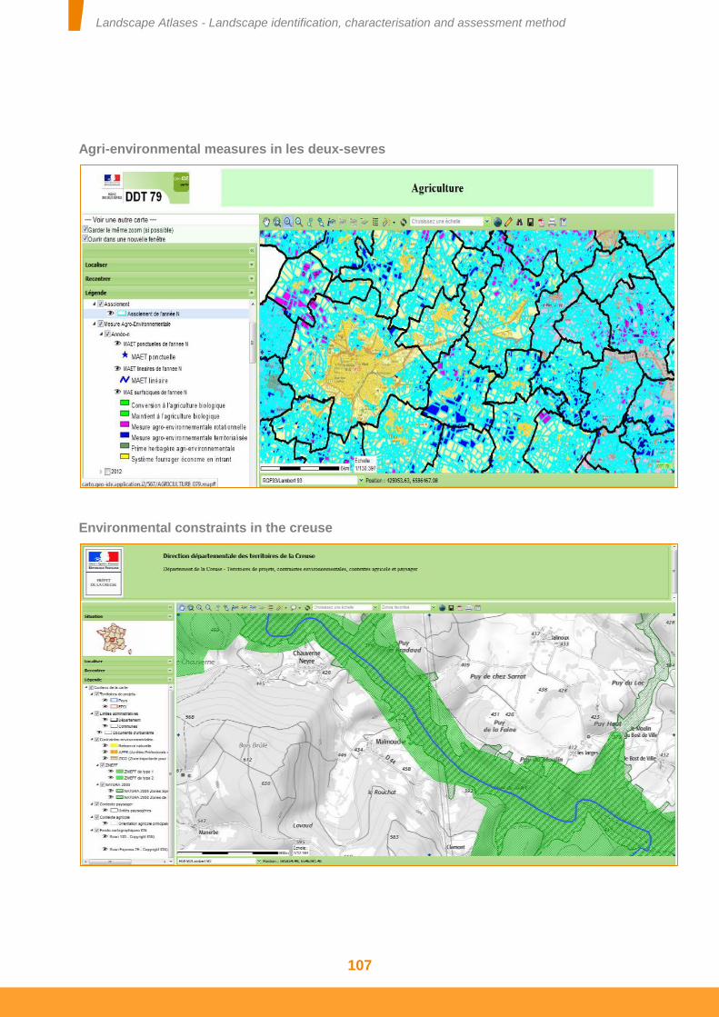
Landscape Atlases - Landscape identification, characterisation and assessment method
107
Agri-environmental measures in les deux-sevres
Environmental constraints in the creuse

Landscape Atlases - Landscape identification, characterisation and assessment method
108

Landscape Atlases - Landscape identification, characterisation and assessment method
109
Bibliography
Landscape Atlases - Landscape identification, characterisation and assessment method
110
BIBLIOGRAPHY
1994 – Méthode pour des Atlas de paysages – Identification et qualification, Yves LUGINBÜHL avec la collaboration de Jean-Claude BONTRON et Zsuzsa CROS, STRATES-CNRS, SEGESA. Commande de la Direction de l’architecture et de l’urbanisme, 80 p.
1995 – Modèles paysagers et représentations du paysage en Normandie-Maine, Nathalie CADIOU et Yves LUGINBÜHL in Paysage au pluriel, pour une approche ethnologique des paysages, Cahier n°9 de la collection Ethnologie de la France, Paris : Ed. de la Maison des sciences de l’homme, p.16-34.
1997 – Court traité du paysage, Alain ROGER, Paris : Gallimard / nrf, bibliothèque des sciences humaines, 199 p.
2001 - La demande sociale de paysage, Yves LUGINBÜHL, Conseil National du Paysage, 21 p. disponible sur www.environnement.gouv.fr/telch/2001-t3/CNPluginbuhl.pdf
2004 - Méthode pour les Atlas de paysages - Enseignements méthodologiques de 10 ans de travaux, Véronique BRUNET-VINCK. Commande du ministère de l’écologie et du développement durable, direction de la nature et des paysages, 48 p.
2007 – Atlas des Paysages de Wallonie, 1. L’Entre-Vesdre-et-Meuse, Marie-Françoise GODART et Jacques TELLER (dir. sc.), Veronica CREMASCO, Anne DOGUET, Nathalie FEREMANS, Claire NEURAY, Thaïs PONS, Claire VAN DER KAA, publication de la Conférence Permanente du Développement Territorial, 263 p.
2008 - Les indicateurs sociaux du paysage, Yves LUGINBÜHL, Monique TOUBLANC, avec la collaboration d’Olivier SINEAU – Rapport commandé par le Ministère de l’écologie, de l’énergie, du développement durable, de la Mer, Direction de l’Habitat, de l’Urbanisme et des Paysages, Bureau des Paysages et de la Publicité.
2009 – Eléments pour la réalisation et l'actualisation des Atlas de paysages. Augustin ROCHE, CNRS-LASYSS, Rapport commandé par le Ministère de l’écologie, de l’énergie, du développement durable et de la mer, 43 p.
2009 – Quelle place pour les paysages urbains dans les Atlas de paysages en France ? Marie VILLOT, Rapport CNRS – Agro-campus Ouest, Angers, 63p. + annexes.
2009 - Conclusions des ateliers Inter-DIREN (Atelier 1, DIREN Centre, Poitou-Charentes et Pays-de-la-Loire, 20 et 21 mars 2008 ; Atelier 2 : DIREN Auvergne, Rhône-Alpes et Bourgogne, 16 et 17 octobre 2008 ; Atelier 3 : DIREN Lorraine et Alsace, 19 et 20 mars 2009 ; Atelier 4 : DREAL PACA, Corse et Rhône-Alpes, 15 et 16 octobre 2009), Rapport du Bureau des Paysages et de la Publicité.
Landscape Atlases - Landscape identification, characterisation and assessment method
111
2009 - Conclusions des ateliers transfrontaliers sur les Atlas de paysages (atelier 1 (France – Wallonie, 2005) architecture générale des Atlas de paysages ; atelier 2 (France – Espagne, 2006) les unités paysagères ; atelier 3 (France – Italie, 2007) les perceptions sociales ; atelier 4 (France-Royaume Uni, 2008) les dynamiques paysagères ; atelier 5 ( France – Catalogne, 2009) les utilisations des Atlas de paysages) , Rapport du Bureau des Paysages et de la Publicité
2011 - Conclusions de la journée d'échanges d'expériences sur la prise en compte des perceptions sociales dans les Atlas de paysages le lundi 7 février 2011, Rapport du Bureau des Paysages et de la Publicité
2011 - Compte rendu de la journée d'échanges d'expériences sur les regroupements et les subdivisions d'unités paysagères dans les Atlas de paysages, 29 avril 2011, Rapport du Bureau des Paysages et de la Publicité
2011 - Compte rendu de la journée d'échanges d'expériences sur la cartographie et les SIG dans les Atlas de paysages, 16 Juin 2011, Rapport du Bureau des Paysages et de la Publicité
2011 - Compte rendu de la journée thématique sur la prise en compte des paysages urbains dans les Atlas de paysages, 27 septembre 2011, Rapport du Bureau des Paysages et de la Publicité
2011 – Compte rendu de la Journée thématique sur l’identification des enjeux dans les Atlas de paysages, 8 décembre 2011, Rapport du Bureau des Paysages et de la Publicité
Ministère de l’Écologie, du Développement durable et de l’Énergie
www.developpement-durable.gouv.frwww.developpement-durable.gouv.fr
Ministry of Ecology, Sustainable Development and Energy
General directorate for Development, Housing and Nature
Landscape office
Sequoia tower92055 La Défense cedex
Tel.: +33 (0)1 40 81 21 22
Landscape AtlasesLandscape identification,
characterisation and assessment method
conception graphique de la couverture et impression : MEDDE/SPSSI/ATL2imprimé sur du papier certifié écolabel européen