Embed Size (px)
Citation preview
SMOS Wind Data Service
Laboratoire d’Océanographie Physique et Spatiale – Z.I. Pointe du Diable-B. P. 70, Plouzané – France Tél. : +33 (0)2 98 22 44 10 – Fax : +33 (0)2. 98. 22. 45. 33 – E-mail : [email protected]
SMOS Wind Data Service SMOS Wind Products Description Document
Attention to: ESA
Function Name Signature Date
Prepared by Consortium IFREMER,ODL
N.Reul, J. Tenerelli,JF Piolle
01/07/2021
Accepted by ESA
technical officer
Raffaele Crapolicchio

SMOS Wind Data Service
Laboratoire d’Océanographie Physique et Spatiale – Z.I. Pointe du Diable-B. P. 70, Plouzané – France Tél. : +33 (0)2 98 22 44 10 – Fax : +33 (0)2. 98. 22. 45. 33 – E-mail : [email protected]
Indexing form
Customer ESA/ESRIN Contract N°4000122821/17/I-EF - Confidentiality codes Document management Company / Programme Defence Non-protected Non-protected None Reserved Limited diffusion Internal
Confidential Defence confidentiality Customer
Contractual document Project N° Work Package Yes No
-
PDD
Summary SMOS wind products description document
Document File name SMOS_WIND_DS_PDD.docx Nbr of pages 29 Project - Nbr of tables 0 Software Microsoft Word 9.0 Nbr of figures 0
Language English Nbr of appendices 0 Document reference Internal SMOS_WIND_DS_PDD.docx Issue 1 Date
External - Revision 6 Date 04/08/2021 Author(s) Verified by Authorised by Nicolas REUL
© IFREMER © ODL 2019 This document is the property of IFREMER and ODL, no part of it shall be reproduced or transmitted without the express prior written
authorisation of IFREMER and ODL
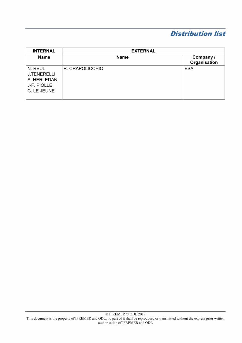
Distribution list
INTERNAL EXTERNAL Name Name Company /
Organisation N. REUL J.TENERELLI S. HERLEDAN J-F. PIOLLE C. LE JEUNE
R. CRAPOLICCHIO ESA
© IFREMER © ODL 2019 This document is the property of IFREMER and ODL, no part of it shall be reproduced or transmitted without the express prior written
authorisation of IFREMER and ODL
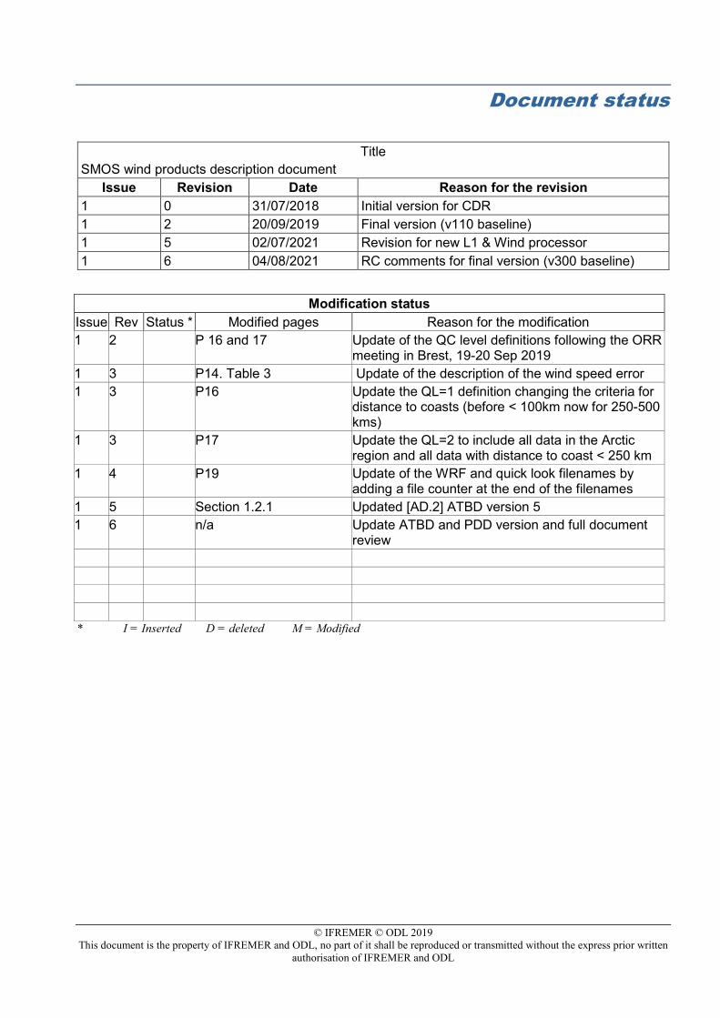
Document status
Title SMOS wind products description document
Issue Revision Date Reason for the revision 1 0 31/07/2018 Initial version for CDR 1 2 20/09/2019 Final version (v110 baseline) 1 5 02/07/2021 Revision for new L1 & Wind processor 1 6 04/08/2021 RC comments for final version (v300 baseline)
Modification status Issue Rev Status * Modified pages Reason for the modification 1 2 P 16 and 17 Update of the QC level definitions following the ORR
meeting in Brest, 19-20 Sep 2019 1 3 P14. Table 3 Update of the description of the wind speed error 1 3 P16 Update the QL=1 definition changing the criteria for
distance to coasts (before < 100km now for 250-500 kms)
1 3 P17 Update the QL=2 to include all data in the Arctic region and all data with distance to coast < 250 km
1 4 P19 Update of the WRF and quick look filenames by adding a file counter at the end of the filenames
1 5 Section 1.2.1 Updated [AD.2] ATBD version 5 1 6 n/a Update ATBD and PDD version and full document
review * I = Inserted D = deleted M = Modified
© IFREMER © ODL 2019 This document is the property of IFREMER and ODL, no part of it shall be reproduced or transmitted without the express prior written
authorisation of IFREMER and ODL
Table of contents
1. INTRODUCTION ......................................................................................................... 7 1.1. Scope and structure of the document ................................................................. 7
1.2. Applicable and Reference Documents ................................................................ 8
1.2.1. Applicable Documents (ADs) ............................................................................ 8
1.2.2. Reference Documents (RDs) ............................................................................ 8
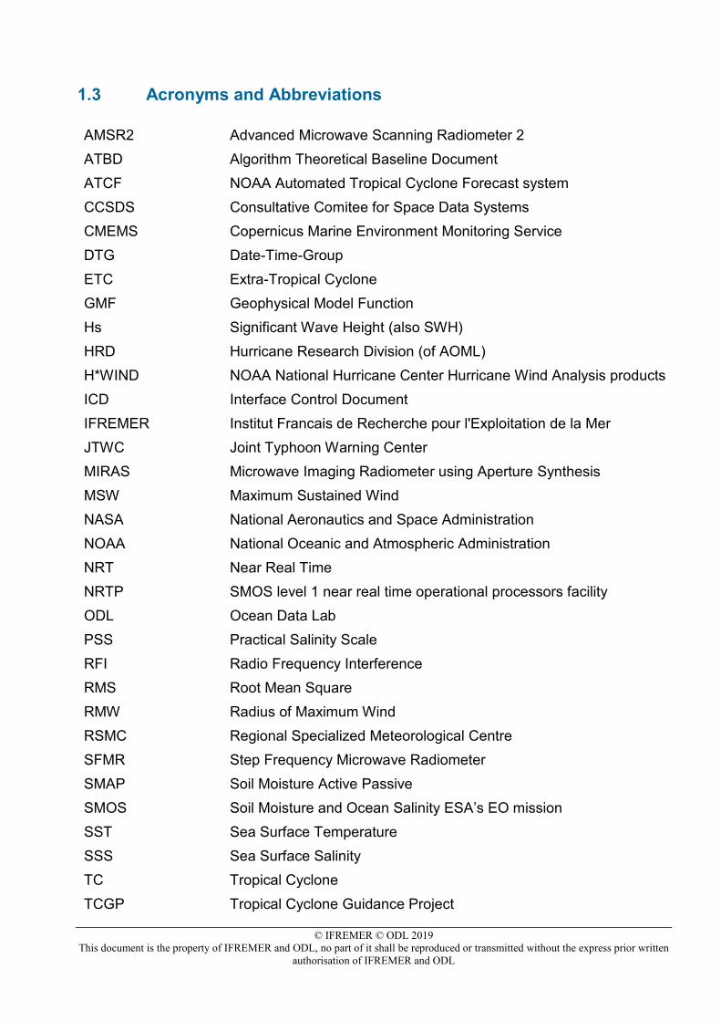
1.3 Acronyms and Abbreviations ........................................................................... 10
2. SMOS WIND DATA SERVICE PRODUCTS ............................................................ 12 2.1. SMOS Near-Real Time Level 2 swath wind speed wind speed Product (SMOS
L2WS NRT) .......................................................................................................... 12
2.1.1. Product description ......................................................................................... 12
2.1.2. File naming convention ................................................................................... 13
2.1.3. Product format description .............................................................................. 14
2.1.4. Product quality information ............................................................................. 15
2.1.4.1 Statistical Estimate of the wind speed error .............................................................. 15 2.1.4.2 Quality Levels of the wind speed .............................................................................. 16
2.2. SMOS Wind Radii Fixes (SMOS WRF) product ................................................ 17
2.2.1. Product description ......................................................................................... 17
2.2.2. File naming convention ................................................................................... 19
2.2.3. Product format description .............................................................................. 20
2.2.4. Quick looks ..................................................................................................... 22
2.3. SMOS Level 3 daily wind speed product (SMOS L3WS) .................................. 23
2.3.1. Product description ......................................................................................... 23
2.3.2. File naming convention ................................................................................... 23
2.3.3. Product format description .............................................................................. 24
2.3.4. Quick looks description ................................................................................... 24
2.4. Products format example ................................................................................... 26

© IFREMER © ODL 2019 This document is the property of IFREMER and ODL, no part of it shall be reproduced or transmitted without the express prior written
authorisation of IFREMER and ODL
© IFREMER © ODL 2019 This document is the property of IFREMER and ODL, no part of it shall be reproduced or transmitted without the express prior written
authorisation of IFREMER and ODL
1. Introduction
1.1. Scope and structure of the document This document is the SMOS Wind Products Description Document (PDD) that describes the data products generated by the ESA/SMOS Wind Data Service operated by IFREMER/OceanDataLab. The SMOS wind Data Service produces 3 types of products:
1. “SMOS Near Real Time Level 2 swath wind speed” (SMOS L2WS NRT) products, which are SMOS retrieved surface wind speed gridded maps with a spatial sampling of 1/4°x 1/4° and consisting of orbital segments (containing parts of ascending and descending half orbits) following the granularity of the SMOS Level 1B near real time (NRT) data products [AD.1]. SMOS L2WS NRT products are available within 4 to 6 hours from sensing and are generated in NetCDF-4 format as described in §2.1,
2. SMOS “wind radii fixes” (SMOS WRF) products. Using the Tropical Cyclones (TCs)
best-track storm center and intensity forecasts from the Automated Tropical Cyclone Forecast System (ATCF) developed by Naval Research Laboratory, Marine Meteorology Division [RD.20], SMOS L2 swath which intercepts current storms are determined. For interceptions with sufficient swath coverage, the processor produces SMOS WRF files generated in the so-called “Fix (F-deck)” ATCF format. The SMOS WRF “fixes” to the best-track forecasts contain: the SMOS 10-min maximum-sustained winds (in knots) and wind radii (in nautical miles) for the 34 kt (17 m/s), 50 kt (25 m/s), and 64 kt (33 m/s) winds per geographical storm quadrants and for each SMOS pass intercepting a TC in all the active ocean basins. SMOS WRF products are available within 4 to 6 hours from sensing and are generated in ASCII format as described in §2.2.
3. the “SMOS Level 3 daily wind speed” (SMOS L3WS) products. SMOS L3WS products are daily composite maps of the collected SMOS L2 swath wind products for a specific day, provided with the same grid than the Level 2 wind data (SMOS L2WS NRT) but separated into ascending and descending passes. SMOS L3WS products are available the day after from sensing and are generated in NetCDF-4 format as described in §2.3. N.B. since product version 300 a three digit file counter has been added to the wind radii fixes filename.
Format file examples for each of these products are given in §2.4.
© IFREMER © ODL 2019 This document is the property of IFREMER and ODL, no part of it shall be reproduced or transmitted without the express prior written
authorisation of IFREMER and ODL
1.2. Applicable and Reference Documents
1.2.1. Applicable Documents (ADs) The following documents, listed in order of precedence, contain requirements applicable to the activity: Table-1: SMOS Wind Data Service Applicable Documents
Ref. Title Code Version Date
[AD.1] SMOS NRT Product Format Specification Document
SO-ID-DMS-GS-0002
4.2 25.03.2019
[AD.2] SMOS Wind Data Service Algorithm Theoretical Basis Document
SMOS_WIND_DS_ATBD 5
04.08.2021
1.2.2. Reference Documents (RDs) The following reference documents are relevant for the SMOS Wind Data Products description: Table-2: SMOS Wind Data Service Reference Documents
Ref. Title Code Version Date
[RD.1] Kerr Yann H and coauthors. The SMOS Mission: New Tool for Monitoring Key Elements of the Global Water Cycle.
Proceedings of the IEEE, 98(5), 666-687. http://doi.org/10.1109/JPROC.2010.2043032
n/a 2010
[RD.2] Mecklenburg S. and coauthors. ESA's Soil Moisture and Ocean Salinity mission: From science to operational applications.
Remote Sensing Of Environment, 180, 3-18. http://doi.org/10.1016/j.rse.2015.12.025.
n/a 2016
[RD.3] SMOS satellite L-band radiometer: A new capability for ocean surface remote sensing in hurricanes.
Journal Of Geophysical Research-oceans , 117
n/a 2012
[RD.4] A revised L-band radio-brightness sensitivity to extreme winds under Tropical Cyclones: the five year SMOSstorm database.
Remote Sensing of Environment 180 (2016)274–291 n/a 10.04.2016
n/a 2016
[RD.5] A new generation of Tropical Cyclone Size measurements from space.
Bulletin of the American Meteorological Society.
n/a 2017
[RD.6] Uhlhorn and co-authors. Hurricane surface wind measurements from an operational stepped frequency microwave radiometer,
Mon. Weather Rev., 135, 3070–3085, doi:10.1175/MWR3454.1.
n/a 2007
[RD.7] Powell M.D. (2010), Near-surface based, airborne, and satellite observations of tropical cyclones, J.C.L. Chan, J.D. Kepert.
(Eds.), Global perspectives on tropical cyclones: From science to mitigation (2nd ed.), World Scientific Publishing Company, pp. 177–199.
n/a 2010
© IFREMER © ODL 2019 This document is the property of IFREMER and ODL, no part of it shall be reproduced or transmitted without the express prior written
authorisation of IFREMER and ODL
[RD.8] Yin, X., J. Boutin, E. Dinnat, Q. Song, and A. Martin, 2016. Roughness and foam signature on smos-miras brightness temperatures: A semi-theoretical approach.
Remote sensing of environment, 180:221–233, 471.
n/a 2016
[RD.9] Oliva R and co-authors. Status of Radio Frequency Interference (RFI) in the 1400–1427MHz passive band based on six years of SMOS mission.
Remote Sensing Of Environment, 180, 64-75. http://doi.org/10.1016/j.rse.2016.01.013
n/a 2016
[RD.10] Boutin, J., and co-authors. Satellite and in situ salinity: understanding nearsurface stratification and sub-footprint variability.
Bull. Am. Meteorol. Soc. 97 (10). http://dx.doi.org/10.1175/BAMS-D-15-00032.1.
n/a 2016
[RD.11] Price, J. F. Upper ocean response to a hurricane.
Journal of Physical Oceanography 11, 153–175.
n/a 1981
[RD.12] Jourdain, N.C and co-authors Observation-Based Estimates of Surface Cooling Inhibition by Heavy Rainfall under Tropical Cyclones.
Journal of Physical Oceanography 43:1, 205-221.
n/a 2013
[RD.13] Wentz, F., The effect of clouds and rain on the Aquarius salinity retrieval.
Remote Sensing Systems Tech. Memo. 3031805, 14 pp. [Available online at http://images.remss.com/papers/aquarius/rain_effect_on_salinity.pdf.]
n/a 2005
[RD.14] SMAP L-Band Passive Microwave Observations Of Ocean Surface Wind During Severe Storms.
Ieee Transactions On Geoscience And Remote Sensing , 54(12), 7339-7350
n/a 2016
[RD.15] Capability of the SMAP Mission to Measure Ocean Surface Winds in Storms.
Bulletin of the American Meteorological Society.
n/a 2017
[RD.16] Using routinely available information to estimate tropical cyclone wind structure.
Mon. Wea. Rev., 144:4, 1233-1247.
n/a 2016
[RD.17] “International Workshop on Measuring High Wind Speeds over the Ocean”-Proceedings.
SMOSSTORMEvolution_WKP_D160
n/a 2017
[RD.18] SMOS L2 OS Algorithm Theoretical Baseline Document.
SO-TN-ARG-GS-0007_L2OS-ATBD
v3.13 2016
[RD.19] Kudryavtsev V.,P. Golubkin, B. Chapron, A simplified wave enhancement criterion for moving extreme events.
Journal of Geophysical Research, Oceans, 120, http://dx.doi.org/10.1002/2015JC011284.
n/a 2015
[RD.20] Sampson, C. R., and A. J. Schrader, The Automated Tropical Cyclone Forecasting System (version 3.2).
Bull. Amer. Meteor. Soc., 81, 1231–1240
n/a 2000
[RD.21] Boutin J. and co-authors. New SMOS Sea Surface Salinity with reduced systematic errors and improved variability.
Remote Sensing Of Environment, 214, 115-134.
n/a 2018
© IFREMER © ODL 2019 This document is the property of IFREMER and ODL, no part of it shall be reproduced or transmitted without the express prior written
authorisation of IFREMER and ODL
1.3 Acronyms and Abbreviations AMSR2 Advanced Microwave Scanning Radiometer 2 ATBD Algorithm Theoretical Baseline Document ATCF NOAA Automated Tropical Cyclone Forecast system CCSDS Consultative Comitee for Space Data Systems CMEMS Copernicus Marine Environment Monitoring Service DTG Date-Time-Group ETC Extra-Tropical Cyclone GMF Geophysical Model Function Hs Significant Wave Height (also SWH) HRD Hurricane Research Division (of AOML) H*WIND NOAA National Hurricane Center Hurricane Wind Analysis products ICD Interface Control Document IFREMER Institut Francais de Recherche pour l'Exploitation de la Mer JTWC Joint Typhoon Warning Center MIRAS Microwave Imaging Radiometer using Aperture Synthesis MSW Maximum Sustained Wind NASA National Aeronautics and Space Administration NOAA National Oceanic and Atmospheric Administration NRT Near Real Time NRTP SMOS level 1 near real time operational processors facility ODL Ocean Data Lab PSS Practical Salinity Scale RFI Radio Frequency Interference RMS Root Mean Square RMW Radius of Maximum Wind RSMC Regional Specialized Meteorological Centre SFMR Step Frequency Microwave Radiometer SMAP Soil Moisture Active Passive SMOS Soil Moisture and Ocean Salinity ESA’s EO mission SST Sea Surface Temperature SSS Sea Surface Salinity TC Tropical Cyclone TCGP Tropical Cyclone Guidance Project

© IFREMER © ODL 2019 This document is the property of IFREMER and ODL, no part of it shall be reproduced or transmitted without the express prior written
authorisation of IFREMER and ODL
WMO World Meteorological Organisation
© IFREMER © ODL 2019 This document is the property of IFREMER and ODL, no part of it shall be reproduced or transmitted without the express prior written
authorisation of IFREMER and ODL
2. SMOS Wind Data Service Products 2.1. SMOS Near-Real Time Level 2 swath wind speed wind speed
product (SMOS L2WS NRT)
2.1.1. Product description The sensor of the ESA’s Earth Observation mission SMOS [RD.1] is a microwave radiometer which operates at L-band (frequency~1.4 GHz, 21 cm wavelength), a protected frequency primarily chosen to allow global measurements of Soil Moisture and Ocean surface Salinity from space [RD.2]. SMOS was launched late 2009 and its sensors provide L-band brightness temperature imaging of the Earth over a ~1000 km wide swath at about ~40 km nominal resolution, and with global coverage in about 3 days. SMOS is a fully-polarized interferometric radiometer and acquires multi-incidence angle (0°-60°) polarized brightness temperature images of an Earth target. It was first demonstrated in [RD.3, RD4] that SMOS L-band passive measurements over the ocean offer new and unique opportunities to complement existing ocean satellite high wind observations in Tropical Cyclones (TCs) and severe weather. The physical basis for surface wind speed retrievals in extreme weather from passive microwave radiometers involves emission from a rough, foam-covered sea surface. In stormy conditions, ocean surface breaking waves generate extensive foam patches and deep bubble layers associated with high emissivity at microwave frequencies. The foam horizontal coverage and thickness extension as wind speed increases towards hurricane force and above and the associated emissivity increase are the basic principles for surface wind speed retrievals from radiometers. This information can be used as a means of remotely measuring surface wind speeds in hurricanes from airborne, or spaceborne, microwave radiometers. The specificity of L-band radiometer is that at an electromagnetic frequency of 1.4 GHz, upwelling radiation are significantly less affected by rain and atmospheric effects than at higher microwave frequencies [RD.13]. In particular, the absorption due to rain of upwelling radiations is two orders of magnitude larger at C-band frequencies than at L-band (see Figure 2 in RD.3). Being negligibly affected by the atmosphere and sea-spray, L-band radiometers therefore uniquely sense the actual ocean surface in Tropical Cyclones. In [RD.4], the SMOS measured L-band storm-induced microwave brightness temperature excess has been related to the surface wind speed. Using a large ensemble of co-located Stepped Frequency Microwave Radiometer aircraft winds [RD.6], and H*WIND analyses [RD.7] with SMOS data collected for an ensemble of Tropical Cyclones (TCs) between 2010 and 2015, the inferred Geophysical Model Function (GMF) is a quadratic relationship of the surface wind speed at a height of 10m (U10). Validation of the inferred surface wind speed products in extreme wind conditions shows that surface wind speed can effectively be retrieved in TCs from SMOS data using this GMF with an RMS error on the order of 5 m s-1 (~10 kt) up to ~50 m s-1 (~100 kt). The surface wind speed retrieval capability demonstrated using SMOS data in storms was later successively extended using the brightness temperature data from another L-band radiometer: the NASA/Soil Moisture Active Passive sensor [RD.14, RD.15]. As fully described in the Algorithm Theoretical Basis Document of the SMOS Wind Data service [AD.2], the process of retrieving the surface wind speed from MIRAS derived brightness temperatures consist in first estimating the residual brightness temperature contrasts which are induced by the wind-generated roughness and foam formations at the
© IFREMER © ODL 2019 This document is the property of IFREMER and ODL, no part of it shall be reproduced or transmitted without the express prior written
authorisation of IFREMER and ODL
sea surface. To do so, the reconstructed MIRAS brightness temperature images are best corrected from all other contributions to the signal using a radiative transfer forward emissivity model forced by auxiliary geophysical data describing the observed scene. These contributions are estimated using semi-empirical electromagnetic models and include the Faraday rotation across the ionosphere, the atmospheric effects, the sea-surface scattered sky and solar radiation contributions, and the near surface thermo-haline condition impacts on the sea surface specular emission. The sum of the previously listed forward model contributions is estimated at antenna level and subtracted to the reconstructed MIRAS Tb to derive an estimation of the residual wind/wave/foam-driven brightness temperature (Tb) contrasts. These steps are followed by the inversion of the residual Tb contrasts in surface wind speed using the so-called « wind Geophysical Model Function (GMF) ». The GMF is valid over the full range of possible wind speeds and was derived by merging the high-wind model function determined in [RD4] with the model function which was specifically developed for the ESA SMOS Level 2 salinity retrieval algorithm [RD.18], itself valid for the low-to-moderate wind speed range (<17 m/s =34 kt). Based on such algorithm, the SMOS sea surface wind speeds are now available from Ifremer in Near Real Time, i.e., between 4 and 6 hours from sensing. We use the SMOS L-band radiometer Level1B NRT swath data of the reconstructed brightness temperature Fourier Components to retrieve surface wind speeds at a height of 10 meters above the sea surface. We produce surface wind speed gridded maps with a spatial sampling of 1/4°x1/4° and consisting of orbital segments (containing parts of ascending and descending half orbits) following the granularity of the SMOS L1 NRT data products [AD.1; AD.6]. The wind speed data NRT product is a new data set, which is generated at global scale but which shall be used preferentially for studying higher wind speeds (above 12 m/s) where the measurement is relatively noisier (low winds). SMOS indeed provides a unique capability to measure wind speeds in intense tropical and extratropical storms, without being affected by rain.
2.1.2. File naming convention The file naming convention for the SMOS near real time Level 2 swath wind speed (SMOS L2WS NRT) product follows the file naming convention as used for the L1B NRT product [AD.1]. The file name for SMOS L2WS NRT product has the following structure: MM_CCCC_TTTTTTTTTT_yyyymmddThhmmss_YYYYMMDDTHHMMSS_vvv_ccc_s.nc where: MM: is the Mission identifier, for the SMOS case it shall be always SM
CCCC: is the File Class, which has three alternatives:
• TEST: for internal testing purposes only (e.g. products generated as input to or output from acceptance testing, etc.)
• OPER: for all files generated in automated processing during mission operation phases
• REPR: for all files generated during a mission reprocessing campaign
TTTTTTTTTT : is the File Type, consisting of two sub-fields: TTTTTTTTTT=FFFFDDDDDD where:
© IFREMER © ODL 2019 This document is the property of IFREMER and ODL, no part of it shall be reproduced or transmitted without the express prior written
authorisation of IFREMER and ODL
• FFFF: is the File Category, this shall be always MIR_. • DDDDDD: is the Semantic Descriptor, described in the Table below for the SMOS
wind Level 2 NRT products.
TYPE OF DATA FILE TYPE
SCNxSW Measurement Mode Science Data Dual-Pol MIR_SCNDSW
Full-Pol MIR_SCNFSW
yyyymmddThhmmss:
• it is the SMOS sensing start time of the data contained in the product, in CCSDS compact format. As SMOS sensing time values will typically have greater precision than a second, the sensing start time is rounded up (this way the period specified in the filename is completely covered by the time period of the data actually contained in it).
YYYYMMDDTHHMMSS:
• it is the SMOS sensing stop time of the data contained in the product, in CCSDS compact format. As SMOS sensing time values will typically have greater precision than a second, the sensing stop time is rounded down (this way the period specified in the filename is completely covered by the time period of the data actually contained in it).
vvv: is the version number of the processor generating the product. ccc: is the file counter (used to make distinction among products having all other filename identifiers identical). The counter shall start at 001 and not 000.
s: is the site instance ID, which for the NRT wind is equal to:
• 7 : IFREMER Near Real Time Processing Centre As for example if the SMOS Wind processor input L1B NRT product in Earth Explorer format is: SM_OPER_MIR_SCNF1B_20180520T134734_20180520T135039_724_001_6 Then the corresponding output SMOS NRT wind speed product in NETCDF-4 format shall be named: SM_OPER_MIR_SCNFSW_20180520T134734_20180520T135039_300_001_7.nc
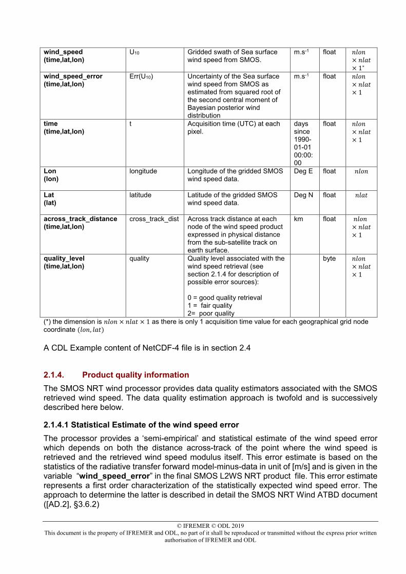
2.1.3. Product format description The SMOS L2WS NRT product file is in native NetCDF-4 format and includes the below variable: Table-3: SMOS L2WS NRT wind speed product content Tag name Variable Description Unit D string
length
© IFREMER © ODL 2019 This document is the property of IFREMER and ODL, no part of it shall be reproduced or transmitted without the express prior written
authorisation of IFREMER and ODL
wind_speed (time,lat,lon)
U10 Gridded swath of Sea surface wind speed from SMOS.
m.s-1 float 𝑛𝑛𝑛𝑛𝑛𝑛𝑛𝑛× 𝑛𝑛𝑛𝑛𝑛𝑛𝑛𝑛× 1∗
wind_speed_error (time,lat,lon)
Err(U10) Uncertainty of the Sea surface wind speed from SMOS as estimated from squared root of the second central moment of Bayesian posterior wind distribution
m.s-1 float 𝑛𝑛𝑛𝑛𝑛𝑛𝑛𝑛× 𝑛𝑛𝑛𝑛𝑛𝑛𝑛𝑛× 1
time (time,lat,lon)
t Acquisition time (UTC) at each pixel.
days since 1990-01-01 00:00:00
float 𝑛𝑛𝑛𝑛𝑛𝑛𝑛𝑛× 𝑛𝑛𝑛𝑛𝑛𝑛𝑛𝑛× 1
Lon (lon)
longitude Longitude of the gridded SMOS wind speed data.
Deg E float 𝑛𝑛𝑛𝑛𝑛𝑛𝑛𝑛
Lat (lat)
latitude Latitude of the gridded SMOS wind speed data.
Deg N float 𝑛𝑛𝑛𝑛𝑛𝑛𝑛𝑛
across_track_distance (time,lat,lon)
cross_track_dist Across track distance at each node of the wind speed product expressed in physical distance from the sub-satellite track on earth surface.
km float 𝑛𝑛𝑛𝑛𝑛𝑛𝑛𝑛× 𝑛𝑛𝑛𝑛𝑛𝑛𝑛𝑛× 1
quality_level (time,lat,lon)
quality Quality level associated with the wind speed retrieval (see section 2.1.4 for description of possible error sources): 0 = good quality retrieval 1 = fair quality 2= poor quality
byte 𝑛𝑛𝑛𝑛𝑛𝑛𝑛𝑛× 𝑛𝑛𝑛𝑛𝑛𝑛𝑛𝑛× 1
(*) the dimension is 𝑛𝑛𝑛𝑛𝑛𝑛𝑛𝑛 × 𝑛𝑛𝑛𝑛𝑛𝑛𝑛𝑛 × 1 as there is only 1 acquisition time value for each geographical grid node coordinate (𝑛𝑛𝑛𝑛𝑛𝑛, 𝑛𝑛𝑛𝑛𝑛𝑛) A CDL Example content of NetCDF-4 file is in section 2.4
2.1.4. Product quality information The SMOS NRT wind processor provides data quality estimators associated with the SMOS retrieved wind speed. The data quality estimation approach is twofold and is successively described here below.
2.1.4.1 Statistical Estimate of the wind speed error The processor provides a ‘semi-empirical’ and statistical estimate of the wind speed error which depends on both the distance across-track of the point where the wind speed is retrieved and the retrieved wind speed modulus itself. This error estimate is based on the statistics of the radiative transfer forward model-minus-data in unit of [m/s] and is given in the variable “wind_speed_error” in the final SMOS L2WS NRT product file. This error estimate represents a first order characterization of the statistically expected wind speed error. The approach to determine the latter is described in detail the SMOS NRT Wind ATBD document ([AD.2], §3.6.2)
© IFREMER © ODL 2019 This document is the property of IFREMER and ODL, no part of it shall be reproduced or transmitted without the express prior written
authorisation of IFREMER and ODL
2.1.4.2 Quality Levels of the wind speed Through an ensemble of tests, conditions for which the surface wind speed retrieval at a given grid node might be degraded are established and associated flags are raised. The combination of flags is used to form final and simple quality level estimates (0=good; 1=fair; 2=poor) which are provided in the final SMOS L2WS NRT product in the variable “quality_level”. We provide a brief description on the quality level conditions here below. They are described in detail the SMOS NRT Wind ATBD document ([AD.2], §3.8). Uncertainty in the SMOS retrieved wind speed can arise from numerous instrumental and geophysical issues. When at least one of these issues arises for a given retrieved wind, the quality flag is set to indicate a possible error in the wind speed. These potential error sources are outlined below. Issues for quality level=1 wind speed Uncertainties in the SMOS retrieved wind speed do include an ensemble of radiometric and forward modeling uncertainties, such as:
• when the World Ocean Atlas monthly Sea Surface Salinity climatology instead of the SSS data from the CMEMS Operational Mercator global ocean forecast system at 1/12 degree (updated daily) are used as the ancillary input salinity field to correct for the specular surface emission during the retrieval process
• If the daily solar flux data from RSGA used to correct for Sunglint effects are unavailable and the last available solar flux dataset is used instead,
• If the brightness temperature dynamic (in time) bias correction (the so-called Ocean Target Transformation or OTT, see [AD.2]) is unavailable then the last available OTT file is used instead,
• If the grid node correspond to a mixed land/ocean pixel, the ocean brightness might be affected by even small land fractions (<0.1)
• If the grid node correspond to a mixed sea-ice /ocean pixel, the ocean brightness might be affected by even small sea ice fraction (>0.01)
• If the land contamination bias correction applied to SMOS data prior the retrieval exhibit a locally high amplitude (default is greater than 1 K)
• If the distance to the nearest coastlines at the retrieved SWS grid node is in between 250 and 500 km, the data can be affected by residual land-sea transition poorly corrected effects (gibbs-like phenomena),
• If the number of multi-angular brightness temperature data used to retrieved the local surface wind is low (default is below 30 first-stokes recombined scenes),
• If the variance of the multi-angular brightness temperature data used to retrieved the surface wind is high (default is greater than 5K) this indicate a non-expected multi-angular variability,
• If an RFI was detected somewhere in the multi-angular images available for retrieval and removed prior the wind speed retrieval
• If the sun glint signal exceed 0.5 K • If the celestial sky radiation exceed 5 K • If the absolute value of the across-track distance is in between 250 and 400
kms.
In either of these conditions, the wind speed quality is expected to be moderately but potentially degraded and the quality level is set to “fair”
© IFREMER © ODL 2019 This document is the property of IFREMER and ODL, no part of it shall be reproduced or transmitted without the express prior written
authorisation of IFREMER and ODL
Issues for quality level =2 wind speed Larger uncertainties in the SMOS retrieved wind speed but still potentially useful (particularly at high winds) conditions do include an ensemble of radiometric and forward modeling uncertainties, such as:
• Large uncertainty in the salinity field can occur in highly dynamical zone like the freshwater plume of large tropical rivers (Amazon-Orrinoco, Mississipi Rivers). In these regions where the temporal standard deviation of the salinity fields, exceed 0.4, the wind speed retrieval occur in an highly variable sea surface salinity (SSS) area: this can potentially translate into an highly biased wind speed retrieval.
• In the Arctic, large uncertainty in the salinity field occur, sea ice contamination and radio-frequency interferences are frequent and degrade the quality of the wind speed retrieval for the Arctic region (defined with a regional Mask available here),
• If the measurement is in a situation where both the WOA SSS climatology was used for the retrieval and the local temporal standard deviation of the salinity fields, exceed 0.4, then the retrieved wind quality will be potentially poor.
• If the distance to the nearest coastlines at the retrieved SWS grid node is less than 250 km, the data are affected by residual land-sea transition poorly corrected effects (gibbs-like phenomena),
• If the daily noon solar flux data from RSGA is missing (then the last available previous day data will be used, which add uncertainty) to correct for sunglint, and if the sunglint forward model still predict a high sunglint contribution to the signal, then, the wind quality might be strongly degraded in and around the sunglint affected regions,
• Quality level 2 will be also set if the number of multi-angular brightness temperatures (Tbs) used for the wind speed retrieval is below a threshold number of 5. In that case, the retrieval is based on very low number of data which can significantly increase the wind speed noise level,
• If the multi-angular Tbs set used for the wind speed retrieval shows a very high variance greater then 20 K, then the data is very likely corrupted by uncorrected perturbances (e.g., RFI),
• If the absolute value of the across-track distance is greater than 400 kms.
2.2. SMOS Wind Radii Fixes (SMOS WRF) product
2.2.1. Product description The SMOS NRT wind processor finds the interceptions of Tropical Cyclones (TC) with the SMOS satellite swaths. For interceptions with sufficient swath coverage, the processor produces TC ASCII files with SMOS 10-min maximum-sustained winds (in kt) and wind radii (in nm) for the 34 kt (17 m/s), 50 kt (25 m/s), and 64 kt (33 m/s) winds for each SMOS pass over a TC in all tropical ocean basins. To determine if an interception has sufficient coverage of a cyclone to produce meaningful wind radii, the processor determines the fractional coverage of the swath winds within 400 km of storm center both for the entire storm and for each of the four geographical quadrants.
© IFREMER © ODL 2019 This document is the property of IFREMER and ODL, no part of it shall be reproduced or transmitted without the express prior written
authorisation of IFREMER and ODL
If the coverage in at least 5% in each quadrant and at least 10% overall then the processor produces a wind radii product. In the first step to determining the wind radii from SMOS wind speed fields, the processor interpolates the 6-hourly cyclone center fixes obtained from the Automated Tropical Cyclone Forecast (ATCF) best-track files ([RD.20] ) which provide the TC center every 6 hours. ATCF best-track files (aka B-decks) are available from the Tropical Cyclone Guidance Project (TCGP) and provide official synoptic hour positions, intensity and wind radii of Tropical Cyclones. The storm center positions provided at synoptic hours are interpolated using cubic Hermite interpolation in time to each satellite swath/storm intercept time (see [AD.2] for details). In the second step, the retrieved wind field is interpolated onto a cylindrical grid centered on the interpolated ATCF storm center. This grid has a radial grid spacing of 10 km and so oversamples the retrieved wind field. At each radius on this grid the fraction of grid points for which valid wind retrievals exist is computed. If this fraction exceeds 50% then the processor computes the fraction of grid points for which the retrieved wind speed exceeds each of the three wind thresholds (34, 50, and 64 kts). The wind speed radius for a given wind threshold is then defined to be the largest radius for which this fraction exceeds 40%. The maximum distance of all wind contour points detected at a given wind speed in a given storm quadrant from the satellite imagery very often provide higher wind radii than the best-track values (see RD.4). Further investigation revealed that these biases are dominantly associated with the presence of small distant patches of high wind speeds often detected in the satellite imagery. The preceding algorithm is designed to reduce this bias. It is important to note that the SMOS sensor has a relatively coarse spatial resolution. The instantaneous field of view is about 40-50 km, although gridded products of ~25km are produced. As shown (RD.16, Knaff et al., 2015), the climatological Radius of Maximum Wind (RMW) in TCs is a function of both the storm center latitude and intensity. RMW decreases equatorward, reaching the smallest values in the tropics (less than 40 nm ~80 km), but is also significantly smaller as storm intensity increases. The climatological RMW is thus ~100 km at tropical storm force decreasing to ~46 km when the Maximum Sustained Wind (MSW) reaches 100 kt (see Figure 2 in [RD.16] ). For MSW higher than this threshold wind speed (Category 3 to 5 in the Saffir-Simpson scale), the RMW exhibits average values below the averaged spatial resolution of the SMOS instrument. In these conditions, the relatively poor spatial-resolution of SMOS radiometer data generally doesn’t allow an accurate determination of the RMW, and results in underestimated MSW above ~100 kt (see discussion in [RD.1] and [RD.14]). The brightness temperature observed in the TCs inner-core region by radiometers with ~40-50 km spatial footprint includes bright contributions from around the maximum wind region and significantly lower brightness power emitted from calm wind region in the eye. The spatial averaging of the antenna therefore results in significantly smoother high wind gradients retrieved from the satellite data than actually encountered in the proximity of the storm inner-core. The RMW is therefore not provided in our products. Nevertheless, we include into the wind Radii products (see further description in §2.2.3) an estimate of the Maximum Wind detected by SMOS imagery: this provides an estimate of the maximum instantaneous wind estimated at ~43 km averaged spatial resolution, which can be approximated by a Maximum 10-minute sustained wind (for a wind speed of 100 kt). Note that the SMOS MSW value is therefore not directly comparable with the 1-minute Maximum Sustained Winds contained in the ATCF best-track data. The relation of 1‐min to 10‐min averaged wind speed is that the latter is 12% smaller (http://www.nhc.noaa.gov).
© IFREMER © ODL 2019 This document is the property of IFREMER and ODL, no part of it shall be reproduced or transmitted without the express prior written
authorisation of IFREMER and ODL
2.2.2. File naming convention The file naming convention for the SMOS WRF file is : SMOS_ yyyymmddThhmmss_RECY_SNAME_FIX_CCC where : yyyymmddThhmmss is the SMOS sensing time of the data located at the storm center location, itself determined from the ATCF best-track data. The sensing time is rounded up.
RECY Each storm is given a unique eight character code called the storm ID to identify it in the ATCF database. The storm ID is of the format RECY, where: RE = Region (basin) of Origin AL - North Atlantic WP - Western North Pacific CP - Central North Pacific EP - Eastern North Pacific IO - North Indian Ocean SH - Southern Hemisphere CY = Annual Cyclone Number(01-99) For northern hemisphere CY is counted from 1 January to 31 December, for southern hemisphere CY is counted from 1 July to 30 June (next year).
SNAME Storm Name given by an international committee of the World Meteorological Organization. CCC is the file counter (used to make distinction among products having all other filename identifiers identical). The counter shall start at 001 and not 000. It can happen that the FIX files are generated several times by the service (e.g., due to changes in the storm track files). To distinguish between these files and to keep them archived, we add a 3 digit file counter (CCC) at the end of the filenames since processor version 300.
Filename examples:

© IFREMER © ODL 2019 This document is the property of IFREMER and ODL, no part of it shall be reproduced or transmitted without the express prior written
authorisation of IFREMER and ODL
SMOS_ 20180110T091256_WP01_BOLAVEN_FIX_001 would be the SMOS fix for the first (01) Western North Pacific (WP) storm, named “BOLAVEN” intercepted by SMOS at 09 :12 :56 on 10 January 2018. SMOS_ 20171201T143406_SH01_ABELA_FIX_001 would be the SMOS fix for the first (01) Southern Hemisphere storm in 2018 cyclone season, named ABELA, even though it is intercepted by SMOS at 14 :34 :06 on 12 December 2017
2.2.3. Product format description The SMOS WRF products are written in a format easy to ingest for TC forecasts, as used in the Automated Tropical Cyclone Forecasting System (ATCF™) at the US Navy. The Automated Tropical Cyclone Forecast System (ATCF ™) is a software application developed by Naval Research Laboratory, Marine Meteorology Division that provides a toolkit to assist the tropical cyclone (TC) forecaster and to automate and streamline the TC forecast process. SMOS is one of the new satellite platform instrument from which we provide new fixes.To be easily ingested into ATCF, SMOS wind radii fixes are therefore produced in the format used by the ATCF “fix”-track files ([RD.23] ). The ATCF f-deck file format description is available at http://www.nrlmry.navy.mil/atcf_web/docs/database/new/newfdeck.txt. Each SMOS WRF file follows the ATCF f-deck conventions and contains a single line for each wind speed for which wind radii are computed (for a total of three lines, for 34 kt, 50 kt, and 64 kt wind speeds). Each line contains the fields detailed in Table-4, separated by commas. Most fields are empty as only a small subset of the total information applies to the SMOS satellite wind speeds. Fields that are provided in the SMOS WRF product are highlighted in grey in next Table-4. Table-4: SMOS WRF product content
Field Description
BASIN basin, e.g. WP, IO, SH, CP, EP, AL, LS
CY annual cyclone number: 1 – 99
YYYYMMDDHHMI Fix Date-Time-Group (DTG): time of SMOS Acquisition at the pixel the closest to the storm center
FIX format 30 (code for “microwave »)
FIX TYPE SMOS (-L-band radiometer)
CENTER/INTENSITY IR (I-Intensity fix,R-wind radii fix)
Flagged Indicator C-center location is flagged, I-intensity is flagged, R-wind radii is flagged, P-pressure is flagged, F-all of the above are flagged, " "-fix is not flagged
LatN/S Latitude of the storm center for the DTG: 0 - 900 tenths of degrees, N/S is the hemispheric index.
© IFREMER © ODL 2019 This document is the property of IFREMER and ODL, no part of it shall be reproduced or transmitted without the express prior written
authorisation of IFREMER and ODL
LonE/W Longitude of the storm center for the DTG: 0 - 1800 tenths of degrees, E/W is the hemispheric index.
Height of observation (meters)
10
Position Confidence Always 1 (- 1-good, 2-fair, 3-poor)
VMAX Maximum SMOS estimated wind speed in knots: 0 - 300 kts.
VMAX Confidence - 1-good, 2-fair, 3-poor
Pressure Not provided by SMOS data, Empty string
Pressure Confidence Not provided by SMOS data, Empty string
Pressure derivation Not provided by SMOS data, Empty string
RAD Wind speed for the radii defined in this record: 34, 50 or 64 kt.
WINDCODE Radius code:
• AAA - full circle • NEQ, SEQ, SWQ, NWQ – quadrant
RAD1 If full circle, radius of specified wind intensity, or radius of first quadrant wind intensity as specified by WINDCODE. 0 - 999 n mi
RAD2 If full circle this field not used, or radius of 2nd quadrant wind intensity as specified by WINDCODE. 0 - 999 n mi.
RAD3 If full circle this field not used, or radius of 3rd quadrant wind intensity as specified by WINDCODE. 0 - 999 n mi.
RAD4 If full circle this field not used, or radius of 4th quadrant wind intensity as specified by WINDCODE. 0 - 999 n mi.
RadMod1 Not provided in this product version. Empty string – Characteristics of the conditions in which the radii are estimated : E-Edge of Pass, C-Cut off by Land, B-Both
RadMod2 Not provided in this product version. Empty string – E-Edge of Pass, C-Cut off by Land, B-Both
RadMod3 Not provided in this product version. Empty string – E-Edge of Pass, C-Cut off by Land, B-Both
RadMod4 Not provided in this product version. Empty string – E-Edge of Pass, C-Cut off by Land, B-Both
Radii confidence Not provided in this product version. Always 1 (- 1-good, 2-fair, 3-poor)
MRD - radius of max winds 0-999 nm
Not evaluated using SMOS data so always set to 0 (convention in agreeement with ATCF and NOAA )
Eye - eye diameter, 0-120 nm
Not provided by SMOS data. Empty string
SUBREGION subregion code: W,A,B,S,P,C,E,L,Q :
A - Arabian Sea
B - Bay of Bengal
C - Central Pacific
E - Eastern Pacific
© IFREMER © ODL 2019 This document is the property of IFREMER and ODL, no part of it shall be reproduced or transmitted without the express prior written
authorisation of IFREMER and ODL
L - Atlantic
P - South Pacific (135E - 120W)
Q - South Atlantic
S - South IO (20E - 135E)
PROJECT ORGANIZATION
Always the string ‘ESA’
SOURCE ORGANIZATION
Always the string ‘IFR’ indicating IFREMER as source of this file.
The remaining fields on each line never change and are retained only for consistency with the ATCF FIX file format. The content of a generic SMOS WRF file is of the form :
BASIN,CY,YYYYMMDDHH, 30,SMOS, IR, , LatN/S, LonE/W, ,1,VMAX, 1, , , , RAD,WINDCODE,RAD1,RAD2,RAD3,RAD4, , , , ,1,0, , SUBREGION, PROJECT ORGANIZATION, SOURCE ORGANIZATION, , , , , , , , , , , , , , , , , , , , , , , , , , , , 1, max. wind is 10 minute sustained
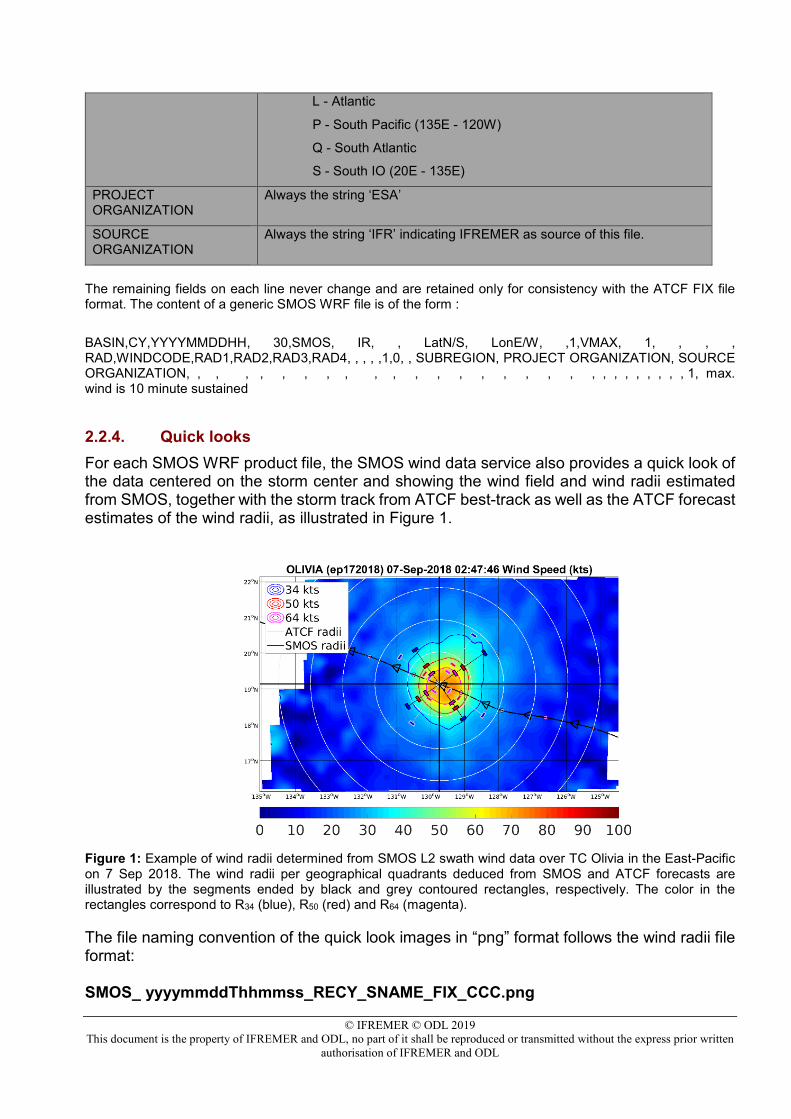
2.2.4. Quick looks For each SMOS WRF product file, the SMOS wind data service also provides a quick look of the data centered on the storm center and showing the wind field and wind radii estimated from SMOS, together with the storm track from ATCF best-track as well as the ATCF forecast estimates of the wind radii, as illustrated in Figure 1.
Figure 1: Example of wind radii determined from SMOS L2 swath wind data over TC Olivia in the East-Pacific on 7 Sep 2018. The wind radii per geographical quadrants deduced from SMOS and ATCF forecasts are illustrated by the segments ended by black and grey contoured rectangles, respectively. The color in the rectangles correspond to R34 (blue), R50 (red) and R64 (magenta).
The file naming convention of the quick look images in “png” format follows the wind radii file format: SMOS_ yyyymmddThhmmss_RECY_SNAME_FIX_CCC.png
© IFREMER © ODL 2019 This document is the property of IFREMER and ODL, no part of it shall be reproduced or transmitted without the express prior written
authorisation of IFREMER and ODL
2.3. SMOS Level 3 daily wind speed product (SMOS L3WS)
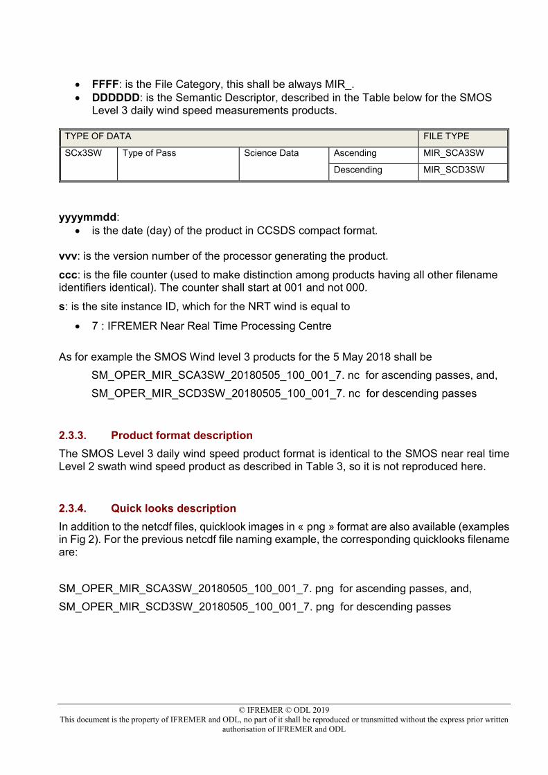
2.3.1. Product description It is very convenient to be able rapidly visualizing the SMOS L2WS NRT swath wind data accumulated for a given full day, particularly in the context of analyzing the reprocessed NRT wind data. To do so, a very simple algorithm [see AD.2] is collecting the SMOS L2WS NRT swath wind product for a specific day and generates global gridded maps of the daily surface winds, separated into ascending and descending passes. These two gridded fields form the SMOS Level 3 daily wind speed products (see Fig. 2). The grid on which the SMOS Level 3 daily wind speed data are generated is identical to the one used for the SMOS L2WS NRT product. The only processing performed in addition to collecting the data of the given day per pass type on the same grid is concerning high latitudes where two successive swaths of the same direction (ascending or descending) might overlap. In this case, the algorithm performs a weighted average of the two measurements available for the same grid node. The idea is to give the priority to the best quality wind retrieval in between the two successive datasets, simply characterized by the theoretical wind speed error variance which is dependent on the across-track location and number of brightness temperature available along the dwell-line used to retrieve the wind but also on the wind speed value itself, as described in the ATBD (AD.2,§3.7.1). Note that the Level 3 daily wind speed products are only available the day after acquisition.
2.3.2. File naming convention The file naming convention for the SMOS Level 3 daily wind speed product has the following structure: MM_CCCC_TTTTTTTTTT_yyyymmdd_vvv_ccc_s.nc where: MM: is the Mission identifier, for the SMOS case it shall be always SM CCCC: is the File Class, which has three alternatives:
• TEST: for internal testing purposes only (e.g. products generated as input to or output from acceptance testing, etc.)
• OPER: for all files generated in automated processing during mission operation phases
• REPR: for all files generated during a mission reprocessing campaign
TTTTTTTTTT : is the File Type, consisting of two sub-fields: TTTTTTTTTT=FFFFDDDDDD
where:
© IFREMER © ODL 2019 This document is the property of IFREMER and ODL, no part of it shall be reproduced or transmitted without the express prior written
authorisation of IFREMER and ODL
• FFFF: is the File Category, this shall be always MIR_. • DDDDDD: is the Semantic Descriptor, described in the Table below for the SMOS
Level 3 daily wind speed measurements products.
TYPE OF DATA FILE TYPE
SCx3SW Type of Pass Science Data Ascending MIR_SCA3SW
Descending MIR_SCD3SW
yyyymmdd: • is the date (day) of the product in CCSDS compact format.
vvv: is the version number of the processor generating the product. ccc: is the file counter (used to make distinction among products having all other filename identifiers identical). The counter shall start at 001 and not 000.
s: is the site instance ID, which for the NRT wind is equal to
• 7 : IFREMER Near Real Time Processing Centre As for example the SMOS Wind level 3 products for the 5 May 2018 shall be
SM_OPER_MIR_SCA3SW_20180505_100_001_7. nc for ascending passes, and, SM_OPER_MIR_SCD3SW_20180505_100_001_7. nc for descending passes
2.3.3. Product format description The SMOS Level 3 daily wind speed product format is identical to the SMOS near real time Level 2 swath wind speed product as described in Table 3, so it is not reproduced here.
2.3.4. Quick looks description In addition to the netcdf files, quicklook images in « png » format are also available (examples in Fig 2). For the previous netcdf file naming example, the corresponding quicklooks filename are: SM_OPER_MIR_SCA3SW_20180505_100_001_7. png for ascending passes, and, SM_OPER_MIR_SCD3SW_20180505_100_001_7. png for descending passes
© IFREMER © ODL 2019 This document is the property of IFREMER and ODL, no part of it shall be reproduced or transmitted without the express prior written
authorisation of IFREMER and ODL
Figure 2: Examples of Level 3 SMOS wind speed products determined from SMOS L2 swath wind data for the 13 Sep 2018. (top) is ascending passes and (bottom) is descending passes. Only dataset with QL=0 and QL=1 is shown on quick look maps.
© IFREMER © ODL 2019 This document is the property of IFREMER and ODL, no part of it shall be reproduced or transmitted without the express prior written
authorisation of IFREMER and ODL
2.4. Products format example An example of a wind radii SMOS NRT file for Atlantic hurricane Igor of 2010 : SMOS_201009100732_AL11 _FIX: AL, 11, 201009100732, 30, SMOS, IR, , 1602N, 2910W, , 1, 38, 1, , , , 34, NEQ, 0, 0, 0, 113, , , , , 1, 0, , L, ESA, IFR, , , , , , , , , , , , , , , , , , , , , , , , , , , , 1, max. wind is 10 minute sustained AL, 11, 201009100732, 30, SMOS, IR, , 1602N, 2910W, , 1, 38, 1, , , , 50, NEQ, 0, 0, 0, 0, , , , , 1, 0, , L, ESA, IFR, , , , , , , , , , , , , , , , , , , , , , , , , , , , 1, max. wind is 10 minute sustained AL, 11, 201009100732, 30, SMOS, IR, , 1602N, 2910W, , 1, 38, 1, , , , 64, NEQ, 0, 0, 0, 0, , , , , 1, 0, , L, ESA, IFR, , , , , , , , , , , , , , , , , , , , , , , , , , , , 1, max. wind is 10 minute sustained
An example of SMOS NRT wind speed netCDF product format: NetCDF-4 SM_OPER_MIR_SCNFSW_20190228T074832_20190228T075044_100_001_7 { dimensions: time = UNLIMITED ; // (1 currently) lat = 721 ; lon = 1440 ; variables: float time(time) ; time:long_name = "time" ; time:units = "days since 1990-01-01 00:00:00 UTC" ; time:standard_name = "time" ; time:authority = "CF-1.7" ; time:axis = "T" ; float lat(lat) ; lat:long_name = "latitude" ; lat:units = "degrees_north" ;
lat:standard_name = "latitude" ; lat:authority = "CF-1.7" ; lat:axis = "Y" ;
float lon (lon) ; lon:long_name = "longitude" ; lon:units = "degrees_east" ;
lon:standard_name = "longitude" ; lon:authority = "CF-1.7" ; lon:axis = "X" ;
float measurement_time(time, lat, lon) ; measurement_time:long_name = "time" ; measurement_time:standard_name = "time" ;
measurement_time:authority = "CF-1.7" ; measurement_time:units = "days since 1990-01-01 00:00:00 UTC" ; measurement_time:coordinates = "time lat lon" ; measurement_time:coverage_content_type = " auxiliaryMeasurement" ;
measurement_time:_FillValue = -999 ; float wind_speed(time, lat, lon) ; wind_speed:long_name = "retrieved wind speed" ;
© IFREMER © ODL 2019 This document is the property of IFREMER and ODL, no part of it shall be reproduced or transmitted without the express prior written
authorisation of IFREMER and ODL
wind_speed:standard_name = " wind_speed" ; wind_speed:authority = "CF-1.7" ; wind_speed:units = "m s-1" ; wind_speed:coordinates = "time lat lon" ; wind_speed:coverage_content_type = "physicalMeasurement" ;
wind_speed:coordinates = "time lon lat" ; wind_speed:_FillValue = -999 ;
float wind_speed_error(time, lat, lon) ; wind_speed_error:long_name = "wind speed error" ; wind_speed_error:units = "m s-1" ; wind_speed_error:coordinates = "time lat lon" ; wind_speed_error:coverage_content_type = "qualityInformation" ; wind_speed_error:_FillValue =-999 ; float across_track_distance(time, lat, lon) ; across_track_distance:long_name = "across track distance" ; across_track_distance:units = "km" ; across_track_distance:coordinates = "time lat lon" ; across_track_distance:coverage_content_type = " auxiliaryMeasurement" ; byte quality_level(time, lat, lon) ; quality_level:long_name = "retrieved wind speed quality level" ; quality_level:coordinates = "time lat lon" ; quality_level:coverage_content_type = "qualityInformation" ; quality_level:flag_meanings = "good fair poor" ; quality_level:flag_values = 0b,1b,2b ; quality_level:_FillValue = -128 // global attributes:
:Conventions = "CF-1.7, ACDD-1.3, ISO 8601" ; :netcdf_version_id = "4.4.1.1 of Nov 21 2017 18:10:30 $" ; :date_created = "2019-03-15T21:19:40" ; :date_modified = "2019-03-15T21:19:40" ; :date_issued = "2019-03-15T21:19:40" ; :id = "SM_OPER_MIR_SCNFSW_L2" ; :naming_authority = "fr.ifremer.cersat" ; :standard_name_vocabulary = "NetCDF Climate and Forecast (CF) Metadata Convention" ;
:Metadata_Conventions = "Unidata Dataset Discovery v1.0" ; :institution = "Institut Francais de Recherche pour l\'Exploitation de la mer, Ocean Data Lab, European Space Agency" ; :institution_abbreviation = "Ifremer/Cersat, ODL, ESA" ; :title = "SMOS Wind Data Service (SWS) product" ; :summary = "Near-Real Time Surface Wind Speed from SMOS satellite and ancillary data on a 0.25 degree resolution grid" ; :cdm_data_type = "grid" ;
:featureType = "grid" ; :keywords = "Oceans > Ocean Winds > Surface Winds" ;
:keywords_vocabulary = "NASA Global Change Master Directory (GCMD) Science Keywords" ;
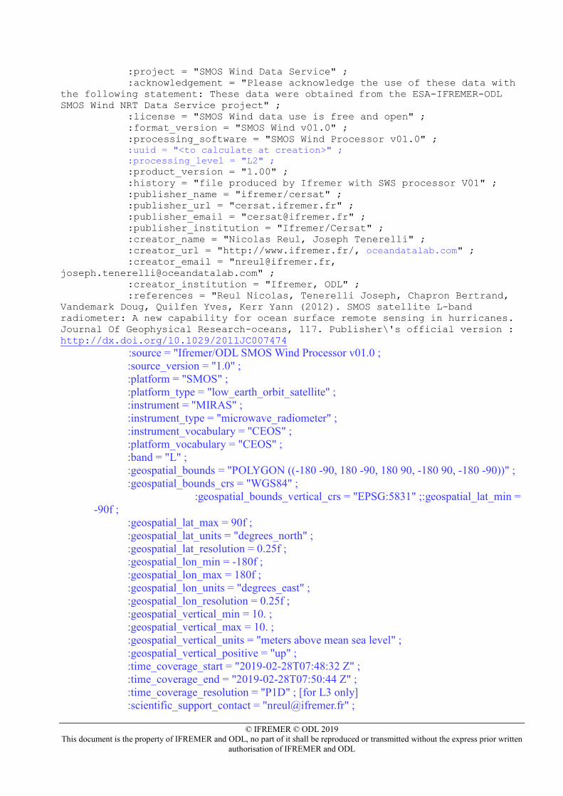
© IFREMER © ODL 2019 This document is the property of IFREMER and ODL, no part of it shall be reproduced or transmitted without the express prior written
authorisation of IFREMER and ODL
:project = "SMOS Wind Data Service" ; :acknowledgement = "Please acknowledge the use of these data with the following statement: These data were obtained from the ESA-IFREMER-ODL SMOS Wind NRT Data Service project" ; :license = "SMOS Wind data use is free and open" ; :format_version = "SMOS Wind v01.0" ; :processing_software = "SMOS Wind Processor v01.0" ;
:uuid = "<to calculate at creation>" ; :processing_level = "L2" ;
:product_version = "1.00" ; :history = "file produced by Ifremer with SWS processor V01" ; :publisher_name = "ifremer/cersat" ; :publisher_url = "cersat.ifremer.fr" ; :publisher_email = "[email protected]" ; :publisher_institution = "Ifremer/Cersat" ; :creator_name = "Nicolas Reul, Joseph Tenerelli" ; :creator_url = "http://www.ifremer.fr/, oceandatalab.com" ; :creator_email = "[email protected], [email protected]" ; :creator_institution = "Ifremer, ODL" ; :references = "Reul Nicolas, Tenerelli Joseph, Chapron Bertrand, Vandemark Doug, Quilfen Yves, Kerr Yann (2012). SMOS satellite L-band radiometer: A new capability for ocean surface remote sensing in hurricanes. Journal Of Geophysical Research-oceans, 117. Publisher\'s official version : http://dx.doi.org/10.1029/2011JC007474 :source = "Ifremer/ODL SMOS Wind Processor v01.0 ; :source_version = "1.0" ; :platform = "SMOS" ; :platform_type = "low_earth_orbit_satellite" ; :instrument = "MIRAS" ; :instrument_type = "microwave_radiometer" ; :instrument_vocabulary = "CEOS" ; :platform_vocabulary = "CEOS" ; :band = "L" ; :geospatial_bounds = "POLYGON ((-180 -90, 180 -90, 180 90, -180 90, -180 -90))" ; :geospatial_bounds_crs = "WGS84" ;
:geospatial_bounds_vertical_crs = "EPSG:5831" ;:geospatial_lat_min = -90f ;
:geospatial_lat_max = 90f ; :geospatial_lat_units = "degrees_north" ; :geospatial_lat_resolution = 0.25f ; :geospatial_lon_min = -180f ; :geospatial_lon_max = 180f ; :geospatial_lon_units = "degrees_east" ; :geospatial_lon_resolution = 0.25f ; :geospatial_vertical_min = 10. ; :geospatial_vertical_max = 10. ; :geospatial_vertical_units = "meters above mean sea level" ; :geospatial_vertical_positive = "up" ; :time_coverage_start = "2019-02-28T07:48:32 Z" ; :time_coverage_end = "2019-02-28T07:50:44 Z" ; :time_coverage_resolution = "P1D" ; [for L3 only] :scientific_support_contact = "[email protected]" ;
© IFREMER © ODL 2019 This document is the property of IFREMER and ODL, no part of it shall be reproduced or transmitted without the express prior written
authorisation of IFREMER and ODL
:source_data = "<files used as input>" ; :technical_support_contact = "[email protected]" ;