Embed Size (px)
Citation preview
���������� ����������������������������������
������������������������������������������������
������� ��������������������������������������!����
������� ����"�����#�������������������������
$�������
����������� �������������� ������������������� ������������� ������
������� ����������� ����� ��� �����
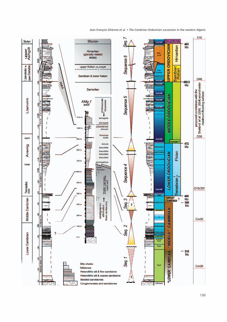
Depositional environments in the 1000–2000 m thick Cambrian-Ordovician succession range from inner-shelf siltstones
to fluvial sandstones. Six transgressive-regressive (T-R), low-frequency (15–25 Ma) depositional sequences have been
differentiated and correlated with both northern distal (Anti-Atlas, Morocco) and southern proximal (Ahnet, southern
Algeria) areas. Sequence 1 (“Lower” Cambrian?) comprises fluvial deposits truncating volcanics and deformed
Panafrican basement rocks. Marine strata appeared in Sequence 2 (lower and middle part of the “Middle” Cambrian) but
fluvial conditions maintained to the South. Sequence 3 (upper “Middle” Cambrian) is erosionally truncated but further
develops to the south, possibly comprising “Upper” Cambrian deposits. In Sequence 4 (Lower Ordovician), fluvial
deposits are no longer present and inner-shelf siltstones reached southern Ougarta. Sequences 5 and 6, upper Lower-
Middle Ordovician and Upper Ordovician, develop inner-shelf conditions throughout the study area at maximum flood-
ing. Hirnantian glacial strata form a lowstand wedge in the upper part of the Sequence 6 regressive system tract. This
succession designates a first-order transgression initiating in the Cambrian. It was temporarily perturbed just before its
end by the Hirnantian glaciation. The related erosion led to a discontinuity, angular at basin scale, falsely suggesting a
pre-glacial tectonic event. The post-glacial transgression, very fast relative to the Cambrian-Ordovician tempo, resulted
in a drastic backstepping of the shorelines that shifted drastically to the south in the early Silurian. After deglaciation, the
first-order inversion trend occurred between retrograding strata of the Cambrian-Ordovician succession and the
prograding Siluro-Devonian wedge. This event marks in North Africa the maximum flooding of the Lower Palaeozoic
megasequence. • Key words: Cambrian, Ordovician, North Gondwana, transgression, glaciation, sequence stratigraphy.
GHIENNE, J.-F., BOUMENDJEL, K., PARIS, F., VIDET, B., RACHEBOEUF, P. & SALEM, H.A. 2007. The Cambrian-Ordovi-
cian succession in the Ougarta Range (western Algeria, North Africa) and interference of the Late Ordovician glaciation
on the development of the Lower Palaeozoic transgression on northern Gondwana. Bulletin of Geosciences 82(3),183–214 (14 figures). Czech Geological Survey, Prague. ISSN 1214-1119. Manuscript received June 25, 2007; accepted
in revised form September 13, 2007; issued September 30, 2007. • DOI 10.3140/bull.geosci.2007.03.183
Jean-François Ghienne, Université Pasteur, CNRS, UMR 7517 Centre de Géochimie de la Surface, Ecole et Observatoiredes Sciences de la Terre, 1 rue Blessig, 67084 Strasbourg Cedex, France; [email protected] •Kheira Boumendjel, SONATRACH, Centre de Recherche et Développement, Av. du 1er novembre, 35000 Boumerdès, Al-geria • Florentin Paris, Géosciences-Rennes, UMR 6118 du CNRS, Université de Rennes 1, 35042 Rennes-cedex, France;[email protected] • Blaise Videt, the same address as the previous author • Patrick Racheboeuf, UMR 6538du CNRS, Université de Bretagne Occidentale, 29385 Brest-cedex, France • Hamid Ait Salem, SONATRACH, Centre deRecherche et Développement, Av. du 1er novembre, 35000 Boumerdès, Algeria
Stratigraphy aims to subdivide sedimentary successions
into correlatable units corresponding ideally to time slices
controlled by biostratigraphy. An extensive and thick sedi-
mentary cover has been noted above the Proterozoic base-
ment in the Sahara (Legrand 1985, Fabre 2005, Fabre &
Kazi-Tani 2005), which extends to the east on the Arabian
Plate (e.g., Sharland et al. 2001). The first and still useful
stratigraphical subdivision was made by Kilian (1922) who
proposed to differentiate three units, from base to top: the
Internal Tassili, later known as the Cambrian-Ordovician
sandstones (e.g., Fabre 1988); the intra-Tassilian trough or
depression characterised by the graptolitic Silurian shales;
the External Tassili, comprising the upper Silurian and De-
vonian shales and sandstones. This study concentrates on
���
the Internal Tassili unit (Cambrian and Ordovician) typi-
fied by huge outcrops of quartz-rich sandstones that pro-
bably represent the most voluminous siliciclastic sequence
ever deposited on continental crust (Burke & Kraus 2000,
Avigad et al. 2005). Geological mapping and extensive
work by petroleum geologists in parallel with the discovery
of new faunas allowed the Cambrian and Ordovician suc-
cession to be further subdivided into four stratigraphic
units (e.g., units I to IV in Beuf et al. 1971), comprising a
number of formations and members (Legrand 1974, 1985).
The fourth unit corresponds to the latest Ordovician (Hir-
nantian), glacially related succession.
Cambrian and Ordovician strata constitute the lower
part of the first-order Lower Gondwana Cycle (Cambrian
to Middle Devonian) of Boote et al. (1998) and essentially
correspond to the second Arabian Plate tectono-strati-
graphic megasequence of Sharland et al. (2001). These
strata were dominated over North Gondwana by fluvial to
inner-shelf deposits. Correlative biostratigraphic data are
relatively sparse with two exceptions: (1) the Anti-Atlas
(southern Morocco, e.g., Destombes et al. 1985, Elaouad-
Debbaj 1988, Gutiérrez-Marco et al. 2003, Bourahrouh etal. 2004) and the Ougarta Range (western Algeria, e.g.,Fekirine & Abdallah 1998, Fabre & Kazi-Tani 2005), two
areas that displayed abundant macrofaunas; (2) palyno-
morphs (chitinozoans, acritarchs) mainly from drill cores
in sedimentary basins (Taugourdeau & de Jekhowsky
1960, Oulebsir & Paris 1995, Vecoli 1999, Vecoli & Le
Hérissé 2004, Paris et al. 2007 and references therein).
Correlation of these fossil-bearing strata with barren flu-
vial (or tidal) sandstones in more proximal, southern parts
of the platform is still debated even though it is of prime
importance in the understanding of the development of
Palaeozoic sedimentary basins on the North African
cratonic platform.
Therefore, this paper aims firstly to provide a basic se-
quence stratigraphic framework for the Cambrian-Ordovi-
cian succession of the Ougarta Range. Based on outcrop
data, a profile nearly parallel to the proximal-to-distal vec-
tor will be examined, with in addition correlations pro-
���
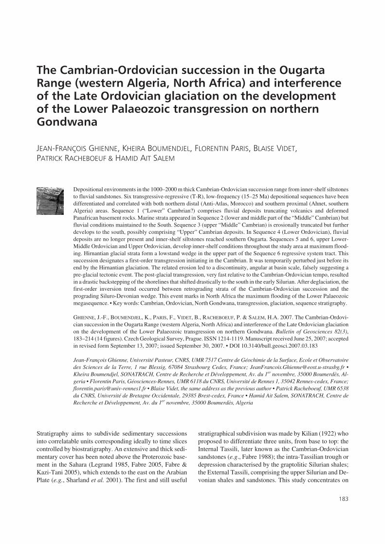
%�����&' Map of northwestern Africa and location of the Ougarta Range on the northeastern margin of the West African Craton (modified from Ennih
& Liégeois 2001). Basement depths around the Ougarta from Takherist (1990).
����������� ������ �������������
100 km
posed with the Anti-Atlas northward and the Ahnet area
southward (ca 900 km from SE to NW, Fig. 1). A number
of stratigraphic sequences will be illustrated and a
depositional model comprising relationships in time and
space from fluvial to inner-shelf deposits will be proposed
in the context of the North African cratonic platform. Then,
the progressive backstepping of the depositional edge upon
the cratonic platform and the signature of intracratonic de-
formation will be discussed. Finally, the impact of the Late
Ordovician glaciation on this otherwise well-organised
succession will be examined.
$�����������������
During the Lower Palaeozoic, North Africa was part of a
regionally continuous clastic-dominated North Gondwana
platform. Fluvial successions in the SSE graded towards
the NNW in storm-to-tide dominated successions. Multi-
phased Palaeozoic to Mesozoic tectonic uplifts have diffe-
rentiated several intracratonic basins, the present geometry
of which bears little relation to the much broader North
Gondwana platform that had an off-shelf gradient towards
the NNW during the whole of the Early Palaeozoic (Beuf etal. 1971, Boote et al. 1998, Carr 2002).
The Ougarta Range is one of these uplifts (Fig. 1),
bounded by the Reggane Bassin to the West and the
Timimoun Basin to the East (Takherist 1990). It corre-
sponds to a folded domain, 120–180 km in width that
trends NW-SE (Fig. 2). Here, thick Lower and Middle
Palaeozoic strata overlying Neoproterozoic rocks have
been deformed in response to the Variscan compressional
event. Thick-skin (Donzeau 1971, 1983) vs thin-skin
(Hervouet & Duee 1996) deformation models have been
proposed. This domain, which links the Pan-African NW
Hoggar towards the South (Fabre et al. 1988), to the Anti-
Atlas towards the North (Burkhard et al. 2006; Fig. 1),
acted repeatedly as an axis of preferential subsidence on
the North Gondwana platform during the Lower
Palaeozoic, as evidenced for instance by: (i) the preserva-
tion of a “Lower” Cambrian succession correlated with the
Adoudounian strata of the Anti-Atlas (Destombes et al.1985; Fabre 1988, 2005); (ii) an Early Ordovician flood-
ing, resulting in the deposition of graptolite-bearing marine
shales delineating an embayment corresponding broadly to
the Ougarta domain outlines (Legrand 1985); (iii) an Ordo-
vician to Devonian depocentre (Fabre & Kazi-Tani 2005).
Donzeau (1974, 1983) interpreted the Ougarta as an
aulacogene structure trending perpendicular to the North
Gondwana margin.
It has been proposed recently that the Ougarta Range
developed onto the northeastern margin of the West Afri-
can Craton (Ennih & Liégeois 2001; Fig. 1). Here, the lat-
est Neoproterozoic post-collisional development of trans-
pressive and then progressively transtensive basins has
resulted in first-order, metacratonic, crustal-scale struc-
tures. It is proposed that the Lower Palaeozoic depocentre
developed on this relatively weaker domain, now inte-
grated to the stable North Gondwana Platform. It has ex-
perienced structural inversion during the Variscan event,
resulting likely in a thick-skinned uplift of the palaeo-mar-
gin of the West African Craton, as documented for instance
��
%�����(' Geological sketch map of the Ougarta Range and synthetic log of the sedimentary succession. The three (NW, intermediate, SE) sections refer
to logs in Fig. 4. Numbers (1–9) refer to logs illustrating the Late Ordovician glacial record in Fig. 6.
����������� ������� ��������� �!"�����#�$%����� ���� �������&� ����'�(����
in the adjacent Anti-Atlas (Donzeau 1974, Faik et al. 2001,
Burkhard et al. 2006).
���������� ��������������������
�������������������
Pioneering works of Menchikoff (1933), Poueyto (1952),
Arbey (1962) and Gomez Silva et al. (1963) proposed the
lithostratigraphic nomenclature that is still currently used
(Legrand 1985, Fekirine & Abdallah 1998; Figs 3, 4).
The definition of lithostratigraphic units was based on both
lithologies and observed bounding discontinuities.
Three sections, representative of the Cambrian-Ordovi-
cian succession in the Ougarta Range, have been logged
(Figs 2–4). Two of them represent the depositional record
at the extremities of a 150 km-long profile, which is ori-
ented from the SE to the NW, i.e. in a direction roughly par-
allel to the palaeocurrent trend recognised both locally in
braided fluvial deposits (dips of cross-strata) and region-
ally (Beuf et al. 1971). The SE sections (Sebkhet el Mellah
and Foum Zeïdiya, Figs 3A, 4C) illustrates proximal depo-
sitional environments, whereas the NW section (Kheneg et
Tlaïa, Figs 3C–E, 4A), located 150 km basinward, corre-
sponds to a notably more distal area. In addition, the NW
section also represents the sedimentary record of an almost
continuously subsiding area characterised by the minor de-
velopment of erosion surfaces and the development of an
exceptionally thick Cambrian-Ordovician sequence. Con-
versely, the SE section illustrates a depositional record in-
cluding well defined erosion surfaces. It is then also transi-
tional with areas recognized to the South of the Ougarta
��!
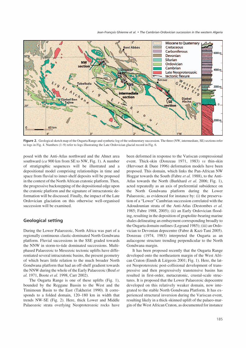
%�����)�������!���' Exposures in the Ougarta Range. • A – Cambrian strata to the north of the Sebket el Melah (SE section). • B – Lower Ordovician
strata in the Kheneg el Aatène (intermediate section). • C – Lower and Upper Ordovician strata in the Kheneg et Tlaïa (NW section).
����������� ������ �������������
*
�
�
where repeatedly uplifted blocks resulted in reduced Cam-
brian-Ordovician sections (e.g., Djebel Hèche, Legrand
1985). An additional intermediate section shows facies and
thickness changes for the Ordovician (Kheneg el Aatène,
Figs 3B, 4B).
������������ ������������
The Cambrian-Ordovician strata in the Ougarta Range
show a great variety in facies associations from fluvial
coarse-grained sandstones to offshore fines, which are re-
presentative of the depositional environments on the North
Gondwana Platform (e.g., Beuf et al. 1971, Eschard et al.2005). Seven depositional environments are basically re-
cognized in the pre-glacial strata: braided fluvial, biotur-
bated sand-flat, mixed tidal and upper shoreface, upper
shoreface, tidal ridges, storm-dominated shoreface and
storm-dominated inner shelf deposits. Glacially related de-
positional environments, uppermost Ordovician in age, are
described independently in a separate section.
Fluvial facies association. – The most common fluvial fa-
cies constitutes the main part of the Sebkhet el Mellah Fm.
and is incidentally present in the Aïn Néchéa Fm. It is made
up of coarse to very coarse arkoses or arkosic sandstones,
comprising essentially 0.3–1 m thick, high-angle trough or
planar cross-laminated bedsets (Fig. 5A). Sandstones are
moderately sorted, with the exception of those underlining
large-scale fining-upward successions that contain granu-
les to gravels (NW section, 0–10 m; SE section, 420 and
505 m). Rip-up clasts are common; overturned beds rare.
Cross-strata consistently dip towards the NW or NNW. Se-
veral metres-thick units are identified, some of them punc-
tuated by thin (0.2–1 m thick) Skolithos-bearing sandstone
beds. The latter horizons are typically better sorted, more
indurated (less arkosic?), contain more rip-up clasts and
show reactivation surfaces in well defined trough
cross-strata.
The bulk of this association has a fluvial origin as sup-
ported by texture and sedimentary structures. The absence
of both overbank deposits and channel structures suggests
amalgamated braided-fluvial channel deposits, with very
large width/depth channel ratios as known in a number of
pre-vegetation braidplains (MacNaughton et al. 1997,
Long 2004). In the Cambrian setting, intervening bio-
turbated and more mature horizons indicate episodic shal-
low-marine conditions, most probably corresponding to
��"
%�����)���������!���' Exposures in the Ougarta Range. • D, E – Upper Ordovician strata in the Kheneg et Tlaïa (NW section).
+
,
����������� ������� ��������� �!"�����#�$%����� ���� �������&� ����'�(����
tidal influences during high frequency transgressive
events.
Subordinate coastal plain and estuarine environments
have also been identified (NW section (390–410 m and
655 m). Very fine-grained, argillaceous and micaceous
sandstones interfinger with dm-thick, cross-laminated,
bioturbated (mainly Skolithos) sandstone beds with occa-
sional liquefaction structures (overturned cross-strata,
flame structures; Fig. 5B). An estuarine or coastal-plain en-
vironment with concomitant fluvial and marine influences
is proposed for those deposits. At the 390 m level, they are
characteristically underlain by braided fluvial sandstones
and overlain by a sharp based, m-thick, cross-stratified bed
deposited in an upper shoreface environment (wave rip-
ples, large Diplocraterion).
Bioturbated sand-flat facies association. – Sand-flat depo-
sits occur in thick, rather monotonous sandstone successi-
ons in the Aïn Néchéa Fm., specially in the SE section
(540–580 m, 610–700 m) as well as in the Kheneg el Aatène
Fm. in the intermediate section (330–380 m). In places,
they are intensively bioturbated by Skolithos (5–100 cm in
length) that may fully obliterate primary sedimentary
structures (“piperocks”). The latter facies develop largely
to the south, e.g., in the Ahnet area (Banquette unit, see be-
low). In the less bioturbated sandstones, low angle to sig-
moidal trough cross-laminated bedsets with reactivation
surfaces are preserved (Fig. 5C). Well defined cyclic suc-
cessions, 3–5 in thickness, may develop in places. Thicken-
ing upward cross-laminated bed sets, which are progressi-
vely more and more bioturbated upwards (Skolithos,
occasional Rusophycus), are truncated by a horizontally to
subhorizontally laminated sandstone bed the top of which
is burrowed by large Diplocraterion.The texture, sedimentary structures and bioturbations
indicate high-energy nearshore environments. Though
most of the Skolithos-generated piperock are classically
attributed to storm-dominated nearshores, tidal influ-
ences are suggested by frequent tidally-bundled, migrat-
ing bedforms (Nio & Yang 1991). The possibility that
Skolithos burrows formed into previously deposited flu-
vial deposits or in mouth-bar sands cannot be rule
out, at least locally. Sandstone beds with horizontal lami-
nation and sparse Diplocraterion reflect episodic higher
energy conditions and preservation of subordinate
storm-related deposits. The bioturbated sand-flat facies
reflects environments located between the shoreline and
shoaling areas beyond which sedimentation was storm
dominated.
Mixed tidal and shoreface facies association. – Mixed ti-
dal and shoreface deposits are recognised in the Aïn Né-
chéa Fm. in the NW section, in the upper Foum Zeïdiya
Fm. in the three sections (e.g., 1620, 1700, 1790 m) and
subordinate occurrences are present in the Bou M’haoud
Fm. Those deposits form 0.5–10 m thick sandstone units
that constitute the upper part of coarsening- and
thickening-upward succession. In places, a poorly deve-
loped (< 1 m), thinning-upward trend is observed on top
of it. Deposits are dominated by medium-grained,
0.2–1 m thick sandstone bed, either amalgamated or with
intervening siltstones. They show a variety of primary se-
dimentary structures: isolated HCS and SCS beds;
0.2–0.5 m thick, low-angle tangential to sigmoidal,
cross-laminated bed sets grading downward in bioturba-
ted bottomsets and including reactivation surfaces under-
lain by a thin (< 2 mm) intercalation of fines or abundant
1–3 cm long rip-up clasts; low-angle to horizontally lami-
nated sandstone beds; wave ripples with straight or poly-
gonal crests; two-dimensional to linguloid current rip-
ples. Those facies are moderately bioturbated, with
Skolithos as the most common structures. Daedalus struc-
tures are relatively abundant in places in the Foum Zeï-
diya Fm. (Lessertisseur 1971). Thin-bedded sandstones
with pervasive mottling concealing primary sedimentary
structures locally form < 1 m thick intervals. Thin-
ning-upward beds in the topmost part of mixed tidal and
shoreface successions are typified by small-scale HCS
beds, wave ripples and may contain shell beds mainly
made up of disarticulated to fragmented linguliformean
brachiopods.
The facies interpretation is based on both the sedimen-
tary structures and the stratigraphic position of these de-
posits. HCS-bearing facies represent open-marine envi-
ronments. Sand waves, common Skolithos and Daedalusstructures point to high-energy tidal-dominated environ-
ments, whereas fully bioturbated facies suggest low-en-
ergy restricted-marine environments. The association of
open-marine, tidal-dominated and restricted-marine de-
posits through high-frequency cycles evidenced by the
potential preservation of fine-grained sediments is inter-
preted as the amalgamation of sands deposited on both
side of a shoaling area with minor preservation of upper
shoreface deposits due to marine erosion. They represent
transgressive facies, as supported by the stratigraphic oc-
currence of the mixed tidal and shoreface facies associa-
tion on top of underlying storm-dominated facies and be-
low overlying thinning-upward sandstones grading to
inner shelf facies.
���
%�����-' Sedimentary logs of the NW, intermediate and SE sections. Macrofauna relates to samples collected in February 2005. Location of section in
Fig. 2.
����������� ������ �������������
��#
����������� ������� ��������� �!"�����#�$%����� ���� �������&� ����'�(����
Upper shoreface facies association. – Whereas thin upper
shoreface deposits have already been reported within the
bioturbated sand-flat facies association, an additional facies
association is proposed here to describe fine-, medium- or
coarse-grained sandstones that constitute 30 m-thick inter-
vals within in the middle part of the Kheneg el Aatène Fm. in
the NW (1170–1200 m) and intermediate (300–325 m) sec-
tions. They comprise amalgamated, m-thick, sandstone beds
within which horizontal to low-angle laminations prevail.
Those laminations locally show 1–4 cm thick, quartz-rich
laminae, separated by black, < 1 mm thick horizons
(Fig. 5D). Very coarse-grained lenses and lags of cm-long
rip-up clasts have been observed. Isolated, erosion based,
cross-bedded sandstone beds are also present, the topmost
part of which comprises horizontal laminae truncating the
underlying oblique laminae.
The predominance of horizontal to low-angle lamina-
tions, in association with thick laminae related to swash
processes in the surf zone, the virtual absence of bio-
turbation and coarse-grained facies suggest a high-energy,
most probably non-barred, upper shoreface environment.
Cross-bedded sandstones were deposited in relation with
longshore or wave-generated cross-shore currents (Clifton
1976).
Storm-dominated shoreface facies associations. – Two ty-
pes of storm-dominated shoreface sandstones have been
identified, an amalgamated and a non-amalgamated type.
Amalgamated shoreface sandstones are present in the three
sections within the lower part of the Kheneg el Aatène Fm.
(NW section, 1060–1010 m) and in the upper part of
the Foum Zeïdiya Fm. (1550–1575, 1600–1630 m). Here,
the facies association that rest above conspicuous
thickening-upward motifs comprising the innershelf facies
association, is mainly made up of sorted fine to medium-
grained sandstones. It is typified by large-scale, amalgama-
ted HCS, micaceous sandstone beds, 0.4–0.8 m in thic-
kness. Undulating laminae are ~2 m and locally up to 4 m
in wavelength, 0.2–0.5 m in amplitude. The degree of
amalgamation generally increases upwards where HCS
beds grade in SCS beds. Bioturbation is virtually absent.
Ovoidal, shell-rich limy concretions are frequent. These
features, 1–2 m × 0.3–0.6 m, bear siltstone clasts and disar-
ticulated faunas such as linguliformean brachiopods and
occasional trilobites, bivalves, gastropods and graptolites.
Non-amalgamated shoreface sandstones have been
identified in the uppermost Aïn Néchéa Fm. in the interme-
diate (0–10 m) and SE (720 m) sections, in the uppermost
Kheneg el Aatène Fm. in the SE section (800 m) and in the
Bou M’haoud Fm. in the NW section (> 1920 m). HCS
beds, 0.2–0.5 m thick, with occasional wave ripples on top,
are separated by siltstone interbeds. They form several
metres-thick thinning upward successions. They are lo-
cally associated with low-angle laminated coarse-grained
sandstones, conglomeratic lenses, or shell beds generally
characterised by disarticulated to fragmented lingulids (up-
permost Aïn Néchéa Fm.) or fragmented echinoderms
(Bou M’haoud Fm.). In the NW section (1940 m), fos-
sil-bearing lenses contain in addition trilobites, brachio-
pods, bryozoans, ostracodes, chitinozoans and scarce
conodonts (Fig. 4).
The predominance of HCS in these sandstones defi-
nitely points to shoreface-dominated facies associations
(Harms et al. 1982, Brenchley et al. 1986). The size of the
HCS in both the amalgamated and non-amalgamated
shoreface sandstones reflects high-energy storm-domi-
nated environments, with preservation in respectively
amalgamated low accommodation and high accommoda-
tion conditions. The former were deposited within long-
term coarsening-upward (regressive) trends whereas the
latter exhibit fining-upward (transgressive) trends. High
accommodation allows wave ripples and fines to be pre-
served, while low accommodation results in amalgamation
of event beds. SCS beds are here interpreted as the result of
increasing amalgamation rates resulting in the systematic
truncation of hummocks in shallower environments
(Dumas & Arnott 2006). Ovoidal, shell-rich concretions
most probably represent the infill by rip currents of
storm-generated large-scale gutter casts. Early cementa-
tion that results in their pre-compaction ovoidal morphol-
ogy, was favoured by the dissolution of the carbonate-rich
shelly fauna.
Inner-shelf facies association. – The inner-shelf facies as-
sociation forms thin (< 5 m) to thick (up to 250 m) succes-
sions that are generally poorly exposed. It comprises the
whole of the Foum Tineslem Fm. and the lower part of the
Foum Zeïdiya Fm. in the three sections. It has been identi-
fied in the Aïn Néchéa Fm. only in the topmost part of the
soft talus in the NW section (640 m). This association
comprises silty shales, micaceous siltstones and heterolit-
hic facies. Heterolithic facies are fine-grained sandstone
beds interstratified with siltstone interbeds. Silty shales
and siltstones with rare sandstone beds typify lower and
middle parts of inner-shelf succession. In the upper part
of the thick inner-shelf successions a conspicuous coar-
sening- and thickening-upwards trend can be observed
with the superimposition of successive 2–4 m thick,
coarsening- and thickening-upwards smaller-scale suc-
cessions. Sandstones initially appear within siltstones as
flaser bedding, grading upwards in 1–4 cm thick rippled
sandstone wavy beds with persistent orientations in
cross-strata dips, followed by the development of
5–20 cm thick HCS beds, firstly lenticular and isolated
with occasional wave reworking on top, then tabular and
progressively amalgamated. Bioturbation is poorly ex-
pressed. Isolated lenticular shell beds with disarticulated
brachiopods and scarce trilobites occur in places.
�#$
����������� ������ �������������
Flasers and thin sandstone wavy beds characterised by
consistent migrations of the foresets suggest distal tempestites
deposited by low-density combined flows. Their association
with relatively thick HCS beds reflects a storm-dominated in-
ner-shelf. Muddy interbeds reflects post-storm deposition of
fine material and/ or fair weather conditions.
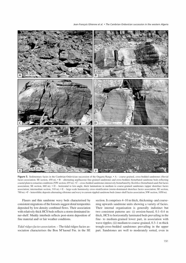
Tidal ridges facies association. – The tidal ridges facies as-
sociation characterises the Bou M’haoud Fm. in the SE
section. It comprises 4–10 m thick, thickening- and coarse-
ning upwards sandstone units showing a variety of facies.
Their internal organisation is generally indistinct but
two consistent patterns are: (i) erosion-based, 0.1–0.4 m
thick, HCS to horizontally laminated beds prevailing in the
fine- to medium-grained lower part, in association with
wave ripples; (ii) medium to coarse-grained, 0.3–1 m thick
trough-cross-bedded sandstones prevailing in the upper
part. Sandstones are well to moderately sorted, even in
�#�
%�����.' Sedimentary facies in the Cambrian-Ordovician succession of the Ougarta Range. • A – coarse-grained, cross-bedded sandstones (fluvial
facies association; SE section, 450 m). • B – alternating argillaceous fine-grained sandstones and cross-bedded, bioturbated sandstone beds reflecting
coastal plain to estuarine conditions (NW section, 655 m). • C – cross-bedded sandstones intensively bioturbated by Skolithos (bioturbated sand-flat facies
association; SE section, 660 m). • D – horizontal to low-angle, thick laminations in medium to coarse-grained sandstones (upper shoreface facies
association; intermediate section, 310 m). • E – large-scale hummocky cross-stratification (storm-dominated shoreface facies association; SE section,
780 m). • F – heterolithic deposits alternating siltstones and wavy to current-rippled sandstone beds (inner-shelf facies association; NW section, 1050 m).
*
� ,
+ %
�
����������� ������� ��������� �!"�����#�$%����� ���� �������&� ����'�(����
coarse-grained facies. Skolithos and shell beds (echino-
derm and brachiopod fragments) are distributed in both fa-
cies.
Large-scale foresets, 6 m in height, have been observed
in one outcrop that we have not had the opportunity to ex-
amine closely. However, we suggest that the facies patterns
described above represent two depositional environments
associated with large subtidal sandridges. Deposits in the
lower part of the individual units show evidence of rework-
ing either by wave or storm. They formed in inter-ridge
areas or correspond to their bottomsets. Trough cross-bed-
ded facies characterise migrating complexes driven by
tidal currents. The frequent occurrence of coarse-grained
sandstones that are usually absent from the shelf, shoreface
or tidal environments may suggest that the tidal ridge facies
association is associated with tidal-dominated delta envi-
ronments.
��������������������������
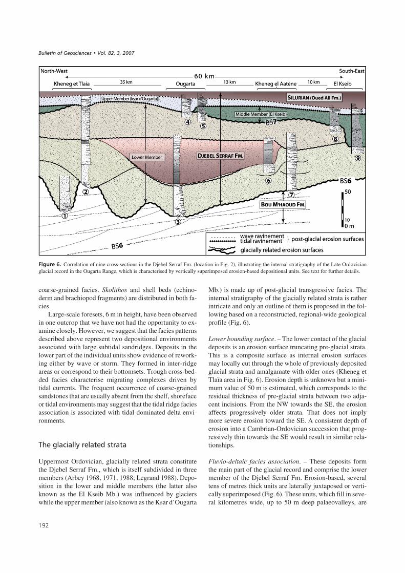
Uppermost Ordovician, glacially related strata constitute
the Djebel Serraf Fm., which is itself subdivided in three
members (Arbey 1968, 1971, 1988; Legrand 1988). Depo-
sition in the lower and middle members (the latter also
known as the El Kseib Mb.) was influenced by glaciers
while the upper member (also known as the Ksar d’Ougarta
Mb.) is made up of post-glacial transgressive facies. The
internal stratigraphy of the glacially related strata is rather
intricate and only an outline of them is proposed in the fol-
lowing based on a reconstructed, regional-wide geological
profile (Fig. 6).
Lower bounding surface. – The lower contact of the glacial
deposits is an erosion surface truncating pre-glacial strata.
This is a composite surface as internal erosion surfaces
may locally cut through the whole of previously deposited
glacial strata and amalgamate with older ones (Kheneg et
Tlaïa area in Fig. 6). Erosion depth is unknown but a mini-
mum value of 50 m is estimated, which corresponds to the
residual thickness of pre-glacial strata between two adja-
cent incisions. From the NW towards the SE, the erosion
affects progressively older strata. That does not imply
more severe erosion toward the SE. A consistent depth of
erosion into a Cambrian-Ordovician succession that prog-
ressively thin towards the SE would result in similar rela-
tionships.
Fluvio-deltaic facies association. – These deposits form
the main part of the glacial record and comprise the lower
member of the Djebel Serraf Fm. Erosion-based, several
tens of metres thick units are laterally juxtaposed or verti-
cally superimposed (Fig. 6). These units, which fill in seve-
ral kilometres wide, up to 50 m deep palaeovalleys, are
�#%
%�����/' Correlation of nine cross-sections in the Djebel Serraf Fm. (location in Fig. 2), illustrating the internal stratigraphy of the Late Ordovician
glacial record in the Ougarta Range, which is characterised by vertically superimposed erosion-based depositional units. See text for further details.
����������� ������ �������������
made up of crudely stratified coarse-grained to argillace-
ous fine-grained sandstones. Erosion surfaces are locally
underlain by conglomerate deposits (intraformational
clasts). Horizontal to subhorizontal laminations are ubiqui-
tous. Current ripples and vertical sheet dewatering structu-
res are subordinate sedimentary structures. These units ge-
nerally fine and thin upwards but one of those shows a
50 m-thick coarsening and thickening upward succession.
Evidence for glacial influences is limited to the occurrence
of poorly preserved intraformational glacial striae as de-
scribed elsewhere in the Late Ordovician record (Deynoux
& Ghienne 2004), and to large-scale (> 50 m) folded and
subsequently truncated structures that are related to glacial
loading processes (Le Heron et al. 2005).
These facies that are characterised by upper-flow re-
gime conditions, and their overall large-scale architecture,
characterise flood-dominated, sediment-laden stream-flow
sediments deposited in proglacial fluvial environments
(Ghienne 2003, Ghienne et al. in press). Delta systems and
related coarsening- and thickening-up successions might
have formed within glacially eroded and subsequently
flooded depressions.
Glaciomarine facies association. – Glaciomarine deposits
constitute the middle member (or El Kseib Mb. sensuLegrand 1988) of the Djebel Serraf Fm. It corresponds to
rather thin (< 25 m thick) and lenticular sandy diamictite
bodies including lonestones, sandstone dykes 0.1–1 m in
thickness and small sandstone channel structures. Resting
on a glacial erosion surface (Arbey 1968), these deposits
reflect subaquatic outwash fan deposition (Powell 1990).
They are ascribed to glaciomarine rather than glaciolacus-
trine facies as they bear abundant chitinozoans of Hirnan-
tian age (elongata Biozone, Paris et al. 1995, 2007). There-
fore, the glacial erosion surface at the base of this middle
member also corresponds to a transgressive surface as it
marks an abrupt and definitive change between underlying
fluvio-deltaic deposits (lower member) and overlying ma-
rine deposits (middle and upper members).
Post-glacial facies association. – Post-glacial deposits
comprise the bulk of the upper member of the Djebel Serraf
Fm. (or Ksar d’Ougarta Member, sensu Legrand 1988) and
constitute a widespread, erosion-based sandsheet that rests
unconformably on underlying glacially-related strata (lo-
wer and middle Mbs.; Figs 6, 7A). This facies association
is made up of medium- to coarse-grained, Skolithos-
bearing, cross-bedded sandstones organised in large low-
angle foresets similar to the tidal ridges facies association
described in preglacial strata. Tidal ridges deposits
are themselves truncated and overlain by coarse- to very
coarse-grained sandstones that bears an abundant macro-
fauna (brachiopods, trilobites; Legrand 1988) and a
few graptolites recalling Normalograptus persculptus
(P. Štorch, written information in 2006). Coarse-grained
sandstones then grade upward rapidly in less than 2 m in
wavy heterolithic fine-grained sandstone beds and then silt-
stones and black shales, uppermost Ordovician and then lo-
wermost Silurian in age.
These deposits are ascribed to a post-glacial trans-
gressive wedge, initially developed in tidal environments
devoid of glacial influences and related to post-glacial
transgressive processes that lag the underlying coarse-
grained glacially-related strata as proposed by Beuf et al.(1971) around the Tuareg Shield (e.g., Ahnet area). Tidal
deposits are themselves truncated by a wave ravinement
surface sealed by shoreface to inner-shelf environments
(Fig. 7A, B).
0�1�������������!��������!�������
�������!� ������������������
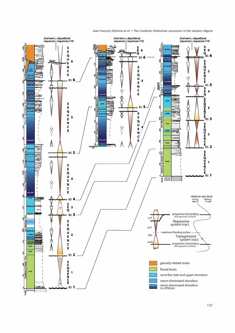
The three sections present a conspicuous cyclic pattern that
is well expressed in the NW section (Fig. 4). Here,
up to 300 m thick fine-grained intervals highlight four
200–400 m thick sandstone units that progressively coar-
sen and then rapidly fine upward (Fig. 3). Sandstone units
form geomorphological markers that can be correlated
throughout the Ougarta Range. Six depositional sequences
and associated bounding surfaces have been identified
(Figs 4, 8). Bounding surfaces generally depart from lithos-
tratigraphic boundaries but depositional cycles correspond
mostly to the regional stages described by Legrand & Na-
bos (1962) and Legrand (1985). Higher frequency units are
also recognizable.
�� ��������������������������������
Three orders of depositional units have been delineated
(Fig. 8). From the thicker to the thinner, they are: (i) depo-
sitional sequences; (ii) short-term sequences; (iii) genetic
units.
Genetic units are 3–20 m in thickness, in places up to
50 m. Although further work is needed to ascertain their
spatial continuity, the genetic units can apparently be cor-
related from the SE to the NW sections, at least those con-
stituting the Foum Zeïdiya Fm. (Fig. 3D). They appear
most often as coarsening and thickening upward assem-
blages, with a thin or absent fining and thinning interval in
their uppermost part. No mappable erosion surface can be
identified and they can be regarded as bounded by high-fre-
quency maximum flooding surfaces. At smaller scale, ge-
netic units internally comprise very high frequency cycles
that are under the resolution of the sedimentary logs used in
this paper. It is speculated that these smaller-scale units
cannot be correlated over long distances as they should rep-
�#�
����������� ������� ��������� �!"�����#�$%����� ���� �������&� ����'�(����
resent the shoreface/ inner-shelf clinoforms that might not
have exceeded ~10 km in length (e.g., Hampson 2000).
Successive genetic units usually display consistent
trends in thickness variations and facies composition. The
stacking pattern of genetic units is then used to define in-
formal short-term sequences that correspond to 100–200 m
thick depositional units, the associated bounding surfaces
of which are generally poorly defined (Fig. 3D, E). This ap-
proach is straightforward in the thick and well developed
shallowing-upward portion of the depositional sequences,
but less easy in the rather condensed deepening-upward
portion of the depositional sequences. Short-term se-
quences are units, which can be correlated at least at the
scale of the Ougarta Range and are also potentially useful
�#�
%�����2' Stratigraphic relationship between glacially-related and post-glacial strata. Tidal deposits are bounded at their base and at their top by
transgressive ravinement surfaces. • A – Ougarta Range (north to the Ksar d’Ougarta). • B – Ahnet area (Idjerrane High, southern Algeria).
����������� ������ �������������
*
�
for long-range correlation. A short-term sequence may
comprise a retrogradational and then progradational suite
of genetic units. One of the two trends generally prevails
and entirely retrogradational or progradational are also
identified. In sand-dominated successions within which
genetic units have not been properly logged (e.g., Aïn
Néchéa Fm. in the SE section), short-term sequence delin-
eation is based on consistent basinward or landward shift of
depositional facies.
Depositional sequences are 300–700 m thick units, the
extent of which largely exceeds the Ougarta Range extend-
ing over the whole of the North African Platform and on its
extension on the Arabian Plate (Sharland et al. 2001,
2004). Six depositional sequences have been distinguished
(Figs 3, 8, 9) that are described in the following. They in-
clude several short-term sequences that are made up of a
suite of genetic units. The delineation of depositional se-
quences is based on the recognition of transgressive and re-
gressive trends. They then correspond to Transgres-
sive-Regressive (T-R) sequences (Embry 1995, Catuneanu
2002) bounded by transgressive surfaces (or surfaces of
maximum regression). T-R sequences predominate due to:
(i) the overall shallow-marine setting within which
highstand- and lowstand-system tracts are poorly differen-
tiated; (ii) major maximum flooding surfaces virtually un-
identifiable at outcrop as they are most often scree-cov-
ered; and (iii) the occurrence of significant transgressive
erosion surfaces. T-R depositional sequences comprise an
underlying transgressive system tract and an overlying re-
gressive system tract (Fig. 8). The transgressive system
tract of T-R depositional sequences comprises a lower,
sand-dominated succession overlain by an upper, rapidly
fining-up succession. The maximum flooding surface that
ideally bound the transgressive and regressive system
tracts has never been properly identified at outcrop as it is
located within the poorly exposed soft talus of offshore fa-
cies (e.g., Fig. 3C). The regressive system tracts are poorly
expressed within Cambrian strata. In the Ordovician they
consist generally in a thick coarsening-up succession, com-
prising shale-dominated sediments at the base and grading
upwards in sand-dominated sediments (e.g., Fig. 3B, D).
They display progressively upwards more and more proxi-
mal short-term sequences. In some case, an additional
stratigraphic surface can be identified that subdivides the
regressive system tract into two packages assimilated as an
underlying highstand and overlying lowstand wedges. Ex-
amples of correlative surfaces of a subaerial unconformity
(end of sea level fall, cf. depositional sequence 4) and basal
surfaces of forced regression (onset of sea level fall, cf.depositional sequence 5) have been evidenced in places.
In the following, depositional sequences identified in
the Ougarta Range (Fig. 8) are described separately and
integrated into a stratigraphic scheme at the platform scale
through a correlation with the synthetic, Cambrian-
Ordovician, basinward succession of the Anti-Atlas, and a
coeval upstreamward succession fringing the Tuareg
shield (Ahnet areas; Fig. 10). This correlation that is based
both on the literature and on recently acquired field
(Anti-Atlas, Ahnet) and biostratigraphic (Ougarta, AMg-1
well, cf. Fig. 9) data illustrates an almost 1000 km long
depositional profile.
�� ������������������������� �!�"#���
Ougarta Range. – This sequence of fluvial deposits has not
been studied in detail; its lower bounding surface (BS1)
truncates the basement rocks. In the NW section, the
Cambrian-Ordovician strata rest with an apparent confor-
mity on rhyodacitic tuffs and lavas. The contact is underlain
by a discontinuous, 0 to 0.2 m thick conglomerate bed over-
lain by a fining-upwards, arkosic, very-coarse to coarse-
grained, cross-bedded sandstones. To the SW, BS1 cut
through a > 4 km thick, steeply dipping folded succession of
sandstones and volcanics (Fig. 2; Caby 1996). Conglomera-
tes that contain fluvially reworked wind-shaped pebbles
(dreikanters) have been documented (Arbey & Caby 1966).
The upper bounding surface (BS2) of depositional se-
quence 1 in the SE section separates the Sebkhet el Melah
and Aïn Néchéa formations. A noticeable lithologic break
is observed between underlying grey arkoses and overlying
red arkosic sandstones. In addition, a prominent metre-
thick silicification affects the topmost deposits. BS2 has
not been observed in the NW section and so it is arbitrarily
placed below arkosic sandstones that here constitute the
upper part of the Sebkhet el Melah Fm., above a broadly
fining-up succession of poorly outcropping fluvial deposits
corresponding to the lower two-thirds of the formation.
Regional correlation. – The lower bounding surface of the
Cambrian-Ordovician succession (BS1 in the Ougarta)
corresponds to the major erosional unconformity that seals
the Pan-African deformation. It is recognised around the
Tuareg shield, where it is called the infra-Tassilian surface
(Beuf et al. 1971, Fabre 2005) and truncates all the defor-
med, more or less metamorphosed Neoproterozoic to basal
Cambrian rocks (sedimentary strata, volcanics, basement
rocks) related to the Pan-African Orogeny and post-col-
lisional collapse/strike-slip basins (Fig. 2). In outcrop, this
is a flat surface but palaeorelief forms are known in places.
This surface corresponds to a major fluvio-eolian by-pass
(Beuf et al. 1971, Eschard et al. 2005) associated with a
stratigraphic hiatus, increasing progressively from north to
south. It is topped by marine uppermost Neoproterozoic –
“Lower” Cambrian strata in Morocco (Destombes et al.1985), whereas it is overlain by younger strata of “Up-
per”(?) Cambrian or Ordovician age in the Hoggar. Coeval
intra-continental depositional systems have developed lo-
�#
����������� ������� ��������� �!"�����#�$%����� ���� �������&� ����'�(����
cally. The arkoses of the Sebkhet el Melah Fm., present in
the whole of the Ougarta or in depocentres such as this rela-
ted to the up to 1 km-thick Ben Tadjine conglomerates in
southwestern Ougarta, are considered to be time-equi-
valent with processes that resulted in the infra-Tassilian
surface to the south (Fabre et al. 1988). Hence, this deposi-
tional sequence is not present in the Ahnet area though coe-
val deposition might have been preserved in places
(e.g., Al Moungar conglomerates in the Tassili areas; Beuf
et al. 1971, Fabre & Kazi-Tani 2005).
This depositional sequence most probably represents in
the Ougarta a late transgressive to early highstand deposi-
tion. To the north, in the Anti-Atlas, the coeval succession
would correspond to the uppermost part of the Western
Anti-Atlas Group. However, the transgressive system tract
is here fully developed including a thick carbonate-domi-
nated succession (Upper Limestone Fm.). The lower Ter-
minal Sandstones Fm. corresponds to the upper part of the
regressive system tract (Landing et al. 2006).
�� ����������������$���%���� �!�"#���
Ougarta Range. – The lithologic break and associated sili-
cification possibly of pedogenetic origin (e.g., Álvaro et al.2003a) suggest that BS2 represents a stratigraphic hiatus
across which sediment source and palaeoenvironments
changed significantly. The second depositional sequence
mainly comprises a transgressive system tract and an over-
lying subordinate regressive system tract. It seals BS2,
which is interpreted as the amalgamation of a subaerial ero-
sion surface with a transgressive surface.
The transgressive system tract is particularly well
expressed in the NW section where a thick deepening-
upward succession of fluvial to shallow-marine deposits is
recorded (NW section, 300–550 m). In the SE section,
marine influences develop progressively upward within an
otherwise fluvial-dominated succession. The regressive
system tract that has not been properly characterised is
represented by fine-grained deposits in the NW section and
by an uninterrupted, 80 m thick, fluvial unit in the SE
section (Fig. 3A). The upper bounding surface (BS3)
involves a subaerial erosion surface. It truncates
underlying marine deposits and is overlain by estuarine
deposits in the NW section while in the SE section, it is an
undulating erosional surface with 1–2 m high palaeorelief
forms underlain by a ferruginous granule lag including
subangular quartz gravels.
Regional correlation. – The transgressive system tract of
depositional sequence 2 correlates to the north with the lo-
wer “Middle” Cambrian transgressive strata constituting
the upper part of the Terminal Sandstones (Tatelt Fm. of
Landing et al. 2006; Fig. 10). In other part of the North
Gondwana domain, deposition of carbonate successions,
either thick as in Turkey (e.g., Dean & Monod 1990, Dean
2005) or rather condensed as in Sardinia (e.g., Pillola et al.1998) is coeval with this worldwide transgression. This
transgressive event marks the onset of the flooding of the
continental platform in the Ougarta Range, which will oc-
cur only later to the south where BS2 should merge with
BS1 to form together the Infra-Tassilian surface (e.g., in
the Ahnet area). On the Arabian Plate, the related maxi-
mum flooding surface most probably correlates to the
Cm20 maximum flooding surface of Sharland et al. (2001).
The regressive system tract correlates with the large-
scale progradation constituting the Internal Feijas Group
overlain by the basal Tabanite Group of Destombes et al.(1985). It is suggested that BS3 in the Ougarta acted as a
bypass surface, which fed in clastics the main part of the
progradation to the north. Early regressive deposits of this
sequence may have a time-equivalent fluvial counterpart to
the south within the Ajjers Fm. of Beuf et al. (1971).
�� ����������������&�
� ����%���� �!�"#���' ( �� �!�"#���)
Ougarta Range. – The third depositional sequence in the
Ougarta is limited to a transgressive system tract constituting
the upper half of the Aïn Néchéa Fm. In the SE section, it
comprises a fining-up succession made up of red, subarko-
sic, unsorted, coarse- to very coarse-grained cross-bedded
fluvial sandstones grading upward into white, quartz-rich
sandstones of the bioturbated sand flat facies association
characterised by the development of abundant Skolithosburrows (Fig. 8). To the NW, thin estuarine deposits under-
line a poorly differentiated 150 m-thick shallow-marine
quartz-rich sandstones dominated by the mixed tidal and
shoreface facies association. It correlates with sandstones,
upper “Middle” Cambrian in age (Vecoli et al. 2007),
which share a similar transgressive trend in the AMg-1
well (Fig. 9). A significant granulometric break is then
used to locate the upper bounding surface of the sequence
(BS4) that most probably corresponds to a tidal ravinement
surface (see below). As in the AMg-1 well, the “Upper”
Cambrian is most probably absent.
�#!
%�����3' Facies and sequence stratigraphic interpretations in the Cambrian-Ordovician succession of the Ougarta Range. Key for sedimentary
structures in Fig. 4. Delineation of Transgressive-Regressive depositional sequence is based on the recognition of transgressive surfaces. The latter merge
in places with erosional surfaces. In a few cases (sequences 4, 5), the regressive system tract has been further informally subdivided based on the
recognition of an internal stratigraphic surface (respectively, a correlative surface of a subaerial unconformity, and a basal surface of forced regression).
����������� ������ �������������
�#"
����������� ������� ��������� �!"�����#�$%����� ���� �������&� ����'�(����
Regional correlation. – Strata coeval of the depositional
sequence 3 biostratigraphically correlates to the Anti-Atlas
with those constituting the middle to upper part of the Ta-
banite Group (Fig. 10). In the Central Anti-Atlas, i.e. in the
axis of the Cambrian depocentre (Destombes et al. 1985), a
30 m-thick Skolithos-bearing sandstone unit is overlain by
a 50-m thick succession dominated by offshore shales.
These strata may represent respectively a transgressive
system tract overlain by the lower part of a regressive as-
semblage. The later strata, “Upper” Cambrian in age (Des-
tombes & Feist 1987), are truncated by coarse-grained sand-
stones underlining the Ordovician rocks. The absence
(Ougarta) or poor development (Anti-Atlas) of the regres-
sive system tract reflect uplift and subsequent erosion rela-
ted to a poorly constrained “Upper” Cambrian tectonic
event, which is identified in Morocco (Destombes et al.1985, Destombes & Feist 1987, Burkhard et al. 2006), and
in some places in Algeria (Legrand 1985, Crossley &
McDougall 1998) and that may reflect distensive deforma-
tion affecting the continental margin further north (Ledru
et al. 1994, Álvaro et al. 2003b). “Upper” Cambrian strata,
however, were developed more largely farther to the east in
other subsiding troughs of the North African platform (Al-
bani et al. 1991, Vecoli et al. 1995, Vecoli 1999). On the
Arabian Plate, the related maximum flooding surface most
probably correlates to the Cm30 maximum flooding sur-
face of Sharland et al. (2001). It is also suggested that de-
positional sequence 3 should be mostly represented to the
south around the Tuareg Shield constituting the main part
of the Ajjers Fm. of Beuf et al. (1971; equal to the Tin Ta-
radjelli unit in the central Tassili type section of Eschard etal. 2005), an area which has not been affected by deforma-
tion at the continental margin.
�� ����������������*������������+��
Ougarta Range. – The fourth depositional sequence com-
prises a thin, rapidly fining-upward transgressive system
tract and an overlying rather thick regressive system tract.
Its lower bounding surface (BS4) corresponding to a major
granulometric break is sealed by a coarse-grained sand-
stone horizon forming the uppermost part of the Aïn Né-
chéa Fm. (e.g., NW section, 790–800 m). It shows succes-
sively: (i) low-angle laminated to cross-bedded sandstones
with Skolithos and disseminated fragments of lingulifor-
mean brachiopods; (ii) a sharp erosional contact overlain
by several sandstone beds containing intraformational
clasts and abundant disarticulated, non fragmented linguli-
formean brachiopods; (iii) in places, as in the NW section
(795 m), a single 30 cm-thick shell-bed, observed at the
very top of the Aïn Néchéa Fm. constituting a regional
marker level (Gomez Silva et al. 1963, Legrand 1985),
which laterally evolves into a several metre thick succes-
sion of unamalgamated sandstone beds of the storm-
dominated shoreface facies association (e.g., intermediate
section, 0–10 m); (iv) argillaceous and glauconitic deposits
constituting the base of the Foum Tineslem Fm. The lower
bounding surface and overlying deposits are interpreted
respectively as a tidal ravinement surface and tidal depo-
sits. The later are truncated by a wave ravinement surface,
and then, overlain by shoreface to inner-shelf deposits for-
ming the lower Foum Tineslem Fm. This association po-
ints to a major transgressive event within the Cam-
brian-Ordovician succession formerly recognised by
Legrand (1985). It is lower Tremadocian in age as dated by
graptolites (Legrand 1966).
The regressive system tract comprises an up to 400 m
thick, well defined coarsening- and thickening-upward
succession of inner-shelf to shoreface deposits constitut-
ing the upper Foum Tineslem Fm. and the lower part of
the Kheneg el Aatène Fm. (Fig. 3B). The thickness of the
regressive system tract notably decreases to the SE where
it is represented by a less than 100 m thick succession,
even disappearing totally to the south (Gomez Silva et al.1963, Legrand 1985, ORGM 2000; Fig. 8). It should be
noted that this thin succession is not the result of erosion
as it comprises a similar succession ending with storm-
dominated shoreface deposit, which indicates condensed
sedimentation (bypass) rather than post-depositional
truncation.
The upper bounding surface of depositional sequence 4
has been placed in the NW section at the boundary between
underlying reddish, subarkosic and micaceous shoreface
�#�
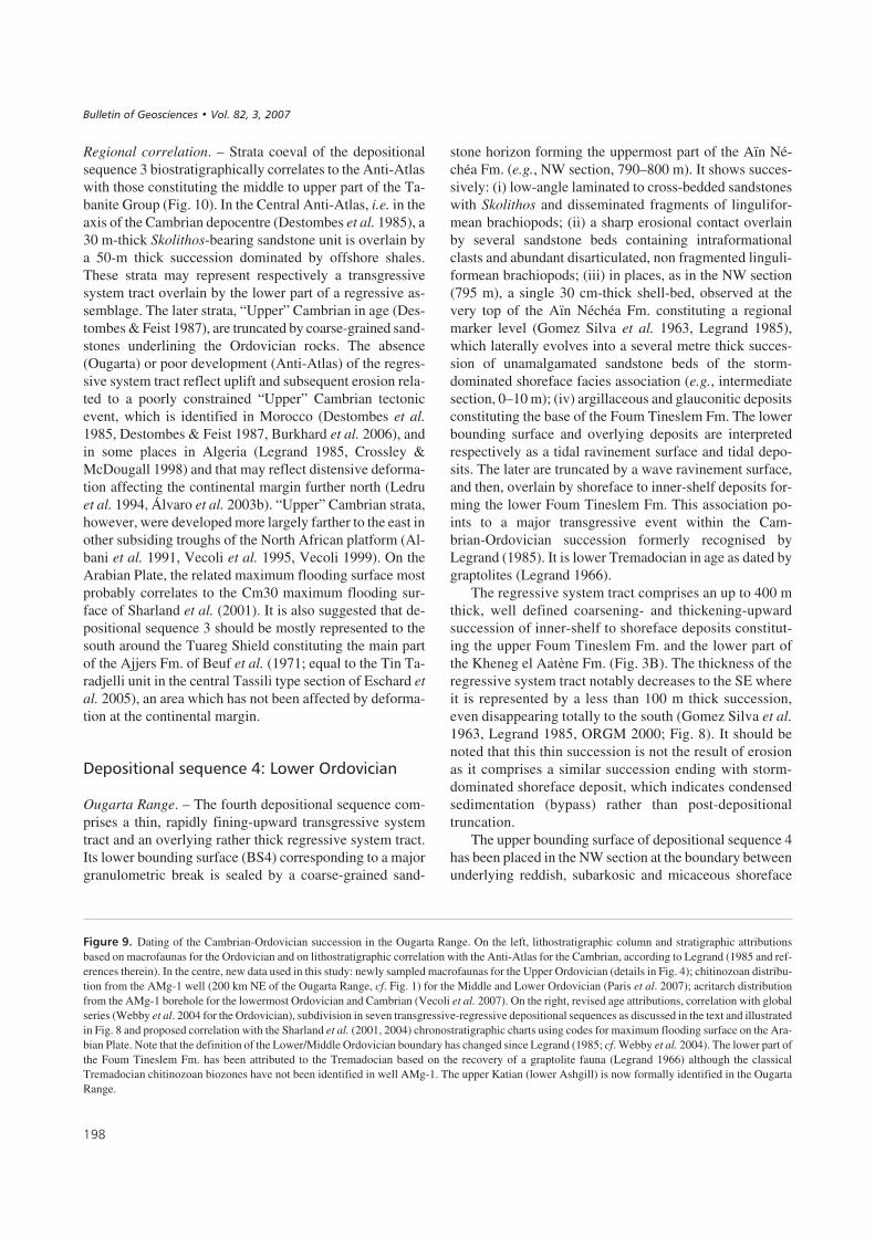
%�����4' Dating of the Cambrian-Ordovician succession in the Ougarta Range. On the left, lithostratigraphic column and stratigraphic attributions
based on macrofaunas for the Ordovician and on lithostratigraphic correlation with the Anti-Atlas for the Cambrian, according to Legrand (1985 and ref-
erences therein). In the centre, new data used in this study: newly sampled macrofaunas for the Upper Ordovician (details in Fig. 4); chitinozoan distribu-
tion from the AMg-1 well (200 km NE of the Ougarta Range, cf. Fig. 1) for the Middle and Lower Ordovician (Paris et al. 2007); acritarch distribution
from the AMg-1 borehole for the lowermost Ordovician and Cambrian (Vecoli et al. 2007). On the right, revised age attributions, correlation with global
series (Webby et al. 2004 for the Ordovician), subdivision in seven transgressive-regressive depositional sequences as discussed in the text and illustrated
in Fig. 8 and proposed correlation with the Sharland et al. (2001, 2004) chronostratigraphic charts using codes for maximum flooding surface on the Ara-
bian Plate. Note that the definition of the Lower/Middle Ordovician boundary has changed since Legrand (1985; cf. Webby et al. 2004). The lower part of
the Foum Tineslem Fm. has been attributed to the Tremadocian based on the recovery of a graptolite fauna (Legrand 1966) although the classical
Tremadocian chitinozoan biozones have not been identified in well AMg-1. The upper Katian (lower Ashgill) is now formally identified in the Ougarta
Range.
����������� ������ �������������
�##
����������� ������� ��������� �!"�����#�$%����� ���� �������&� ����'�(����
sandstones and overlying white quartzitic tidal and shore-
face sandstones. The occurrence of a ferruginous, con-
glomeratic and oolitic horizon that is reported in the litera-
ture within the Kheneg el Aatène Fm. (Gomez Silva et al.1963, Fekirine & Abdallah 1998) is used to tentatively
differentiate the correlative surface of a subaerial uncon-
formity (Fig. 8). In the SE section, a thin (< 10 cm) con-
glomerate bed underlines a well defined truncation sur-
face. Here the transgressive bounding surface is therefore
superimposed onto a truncation surface. In the absence of
fluvial deposits that might have been reworked during sub-
sequent transgression, subaerial erosional processes cannot
be ascertained. High frequency regressive and transgres-
sive marine ravinement processes might have occurred
with no emersion.
Regional correlation. – The transgressive system tract of
the fourth depositional sequence is time-equivalent with
an up to 100 m-thick argillaceous succession in the
Anti-Atlas (lower Lower Fezouata shales; Fig. 10). To
the south, the transgressive system tract finds a parallel
with the uppermost part of the Ajjers Fm., especially
where it comprises a fluvial-estuarine-sand flat succes-
sion (e.g., the central Tassili type section, Eschard etal. 2005). On the Arabian Plate, Sharland et al. (2001)
have identified two, Lower Ordovician, maximum flood-
ing surfaces (O10, O20) that have not been distinguished
from the Ougarta record. Either amalgamation may have
occurred or one of these two events is less significant and
only related to a short-term sequence. However, both
events seem to be represented in the Anti-Atlas (Destom-
bes et al. 1985).
Regressive deposits correspond in the Anti-Atlas to a
thick succession including the upper Lower Fezouata
shales (upper Tremadocian) and the Upper Fezouata shales
(Floian, or lower Arenig) of Destombes et al. (1985) while
to the south, they are either absent (e.g., the Ahnet section,
Fig. 10) or poorly developed. If present, they correspond to
a thin prograding succession (unit of the Vire du Mouflon
of Eschard et al. 2005). In subsurface of Algeria, the re-
gressive system tract comprises the El Gassi shales and El
Atchane sandstones (Fekirine & Abdallah 1998).
A time-equivalent erosional truncation, similar to the
BS 4 in southeastern Ougarta, has also been identified in
other places on the platform, e.g., in the Nl-2 borehole with
superimposed Lower and Middle Ordovician marine
shales and no intervening evidence for fluvial deposition
(Oulebsir & Paris 1995).
�� ����������������,�
� �������������+��'%���������+��
Ougarta Range. – Above bounding surface 5, the fifth de-
positional sequence comprises a transgressive system tract
that progressively developed to the north where it corres-
ponds the upper Kheneg el Aatène and lower Foum Zeïdiya
fms. The subsequent regressive system tract constitutes the
middle and upper Foum Zeïdiya Fm.
At its base, the transgressive system tract comprises rel-
atively thick (60 m) deposits of the tidal and shoreface fa-
cies association (Fig. 3B). They are overlain by several
sandstone beds containing intraformational clasts and
abundant disarticulated, non fragmented linguliformean
brachiopods similar to those of the basal part of depo-
sitional sequence 4. An overlying short-term sequence is
capped by an oolitic ironstone horizon also including
linguliformean brachiopods. This short-term sequence in-
cludes upper Arenig (lower Middle Ordovician, i.e.Dapingian) graptolites (Legrand 1964) and time-equiva-
lent chitinozoans (bulla Biozone) are found within the
ironstone horizon in the AMg-1 well (Benoît &
Taugourdeau 1961). To the south, the transgressive system
tract is limited to several, unamalgamated beds of the
storm-dominated shoreface facies association here includ-
ing conglomerate lenses.
The regressive system tract includes a well defined
coarsening-upward succession of short-term sequences
with alternating inner shelf and storm shoreface or tidal
and shoreface facies associations (Fig. 3D). An abundant
macrofauna designates this interval as an essentially Dar-
riwilian succession (Figs 4, 9). The upper bounding sur-
face corresponds to an erosional surface sealed with
transgressive lag deposits (see below). However, some
metres or tens of metres beneath the sequence boundary,
an abrupt contact has been systematically noted that su-
perimposes tidal or shoreface onto underlying inner shelf
deposits (Fig. 8). This stratigraphic surface is tentatively
interpreted as reflecting the onset of a major sea-level fall
(as the basal surface) with overlying strata featuring a
lowstand system tract.
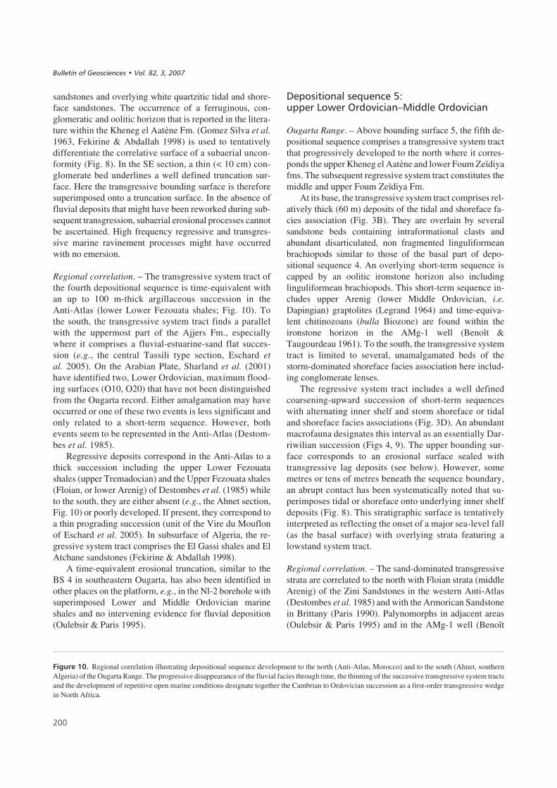
Regional correlation. – The sand-dominated transgressive
strata are correlated to the north with Floian strata (middle
Arenig) of the Zini Sandstones in the western Anti-Atlas
(Destombes et al. 1985) and with the Armorican Sandstone
in Brittany (Paris 1990). Palynomorphs in adjacent areas
(Oulebsir & Paris 1995) and in the AMg-1 well (Benoît
%$$
%�����&5' Regional correlation illustrating depositional sequence development to the north (Anti-Atlas, Morocco) and to the south (Ahnet, southern
Algeria) of the Ougarta Range. The progressive disappearance of the fluvial facies through time, the thinning of the successive transgressive system tracts
and the development of repetitive open marine conditions designate together the Cambrian to Ordovician succession as a first-order transgressive wedge
in North Africa.
����������� ������ �������������
%$�
����������� ������� ��������� �!"�����#�$%����� ���� �������&� ����'�(����
& Taugourdeau 1961) show that the transgression began as
early as the upper Floian (middle Arenig, brevis event of
Paris et al. 2007) with another pulsation in the lowermost
Darriwilian (uppermost Arenig, bulla event of Paris et al.2007). This two-fold transgression is tentatively conside-
red as parallel to the two short-term sequences identified
in the Ougarta (intermediate section, 330–400 m), with se-
vere condensation of deposits occurring during the Dapin-
gian (upper Arenig), e.g., in Brittany (Dabard et al. 2007)
and illustrating in the Ougarta by shell beds and associated
ironstones. Maximum flooding conditions occurred
slightly later during the early Darriwilian and correspond
to the formosa event of Paris et al. (2007). On the Arabian
Plate, the related maximum flooding surface correlates to
the O30 maximum flooding surface of Sharland et al.(2001).
To the south, the basal transgressive system tract
forms a regionally widespread sandstone sheet known in
subsurface as the Hamra Quartzites, or the Banquette unit
in the Tassili, comprising mainly sand-flat Skolithos-rich
deposits (Fig. 10). In places, this unit onlaps onto base-
ment rocks (Beuf et al. 1971). In the Ahnet, tidal deposits
comprise the maximum flooding thought more largely
open marine conditions might have occurred coevally in
more subsiding areas such as in the Tassili (Eschard et al.2005).
Further south, regressive strata form mainly the shore-
face-dominated In Tahouite Fm. (e.g., Eschard et al.2005). The regressive system tract correlates to the north
with the Tachilla shales grading upwards into the sand-
stones of the First Bani Group (Destombes et al. 1985) of
late Darriwilian age. If the identification of a basal
sea-level fall surface in uppermost depositional sequence
5 is correct, the overlying strata can be considered as
time-equivalent at least with the lower part of the First
Bani Group. Strata of the upper First Bani Group, Late
Darriwillian to early Sandbian, might represent late
lowstand conditions not represented in the more proximal
Ougarta Range.
�� ����������������-��( �������+��
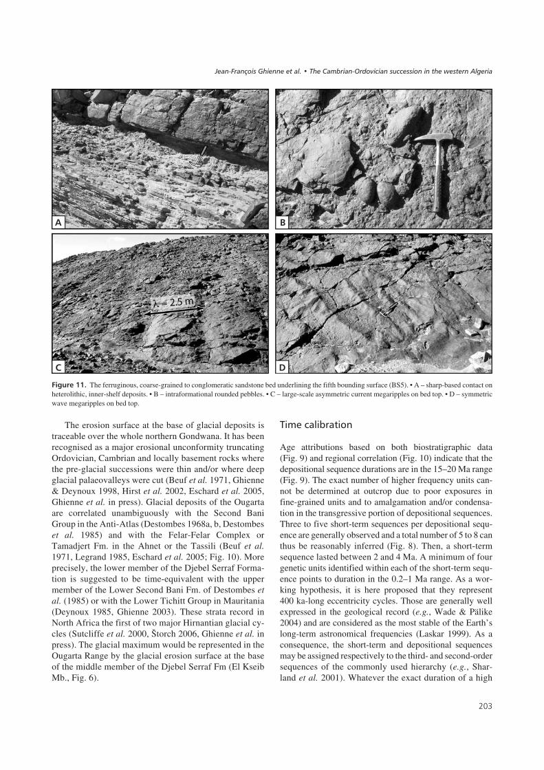
Ougarta Range. – The bounding surface 5 corresponds to
the base of the Bou M’haoud Fm. (Gomez Silva et al.1963). This flat surface is sharp at the outcrop scale
(Fig. 11A) and erosional at the regional scale. To the south,
it rests on progressively older and older genetic units of the
underlying Foum Zeïdiya Fm. (compare Figs 4A–C). The
erosion surface is underlain by ferruginous, coarse-grained
to conglomeratic sandstones with occasional Skolithos.
Sandstones are characterised by: (i) the occurrence of intra-
formational, rounded pebbles 3–25 cm in diameter
(Fig. 11B); (ii) gravely, 40 cm-high asymmetric megarip-
ples, 2.5 m in wavelength with pebble concentrations in
their troughs (Fig. 11C); (iii) coarse-grained, 5–15 cm-high
symmetric megaripples, 0.5 m in wavelength (Fig. 11D),
with wave ripples in their troughs. Siltstones and shales
rest abruptly above the coarse-grained sandstones. BS5
truncates and is overlain by marine deposits. Sedimentary
structures in associated coarse-grained sandstones point to
processes related to lag deposits in high-energy gravelly
shoreface to offshore environments (e.g., Leckie 1988,
Hart & Plint 1989). The coarse-grained sandstone bed re-
presents the only developed transgressive system tract,
implying the transgression was non-accretionnary in the
Ougarta Range (Helland-Hansen & Gjellberg 1994).
Above, stacked sandstone-dominated high frequency
sedimentary cycles, and deep truncation by the overlying
glacially related surface limits sequence stratigraphic in-
terpretations (Fig. 3E). Pre-glacial strata, mostly
Sandbian and early Katian (Caradoc and lower Ashgill)
in age (Fig. 9) are ascribed to the lower part of a regressive
system tract. The regressive system tract extends within
the glacially-related strata (Figs 3D, E, 8, 9). The fluvio-
deltaic sandstones (lower member of the Djebel Ser-
raf Fm.) that fill in palaeovalleys or depressions bounded
by a subaerial to subglacial unconformity (Fig. 6) consti-
tute a lowstand wedge at the top of the regressive system
tract. The stratigraphic attribution of the glaciomarine and
tidal deposits (respectively the middle and upper mem-
bers of the Djebel Serraf Fm.) will be discussed latter.
They are ascribed to the transgressive system tract of a
seventh depositional sequence extending into the lower
Silurian strata, with a subsequent regressive system tract
represented by the Silurian-Early Devonian prograding
wedge (Fig. 2).
Regional correlation. – The sixth depositional sequence
has a poorly developed transgressive system tract, which
may, however, be present to the south, e.g., in the Ahnet,
where time-equivalent strata might correspond to
sand-flat deposits observed in zones of lesser glacial ero-
sion. To the north in the Anti-Atlas, sedimentation is do-
minated by severe condensation (phosphatic and/ or fer-
ruginous horizons). Alternatively, the regressive system
tract mainly corresponds to the thick Ktaoua Group exten-
ding from the lower (but not lowermost) Sandbian to the
Katian (lower Caradoc to pre-Hirnantian Ashgill; Des-
tombes et al. 1985, Elaouad-Debbaj 1987, 1988; Bourah-
rouh et al. 2004). Southward, decreasing thickness of re-
gressive strata in combination with potentially increasing
glacial erosion together result in poor preservation of coe-
val strata, which are, however, locally preserved (Leg-
rand 1985, Kichou-Braîk et al. 2006). On the Arabian
Plate, the related maximum flooding surface most pro-
bably correlates to the O40 maximum flooding surface of
Sharland et al. (2001).
%$%
����������� ������ �������������
The erosion surface at the base of glacial deposits is
traceable over the whole northern Gondwana. It has been
recognised as a major erosional unconformity truncating
Ordovician, Cambrian and locally basement rocks where
the pre-glacial successions were thin and/or where deep
glacial palaeovalleys were cut (Beuf et al. 1971, Ghienne
& Deynoux 1998, Hirst et al. 2002, Eschard et al. 2005,
Ghienne et al. in press). Glacial deposits of the Ougarta
are correlated unambiguously with the Second Bani
Group in the Anti-Atlas (Destombes 1968a, b, Destombes
et al. 1985) and with the Felar-Felar Complex or
Tamadjert Fm. in the Ahnet or the Tassili (Beuf et al.1971, Legrand 1985, Eschard et al. 2005; Fig. 10). More
precisely, the lower member of the Djebel Serraf Forma-
tion is suggested to be time-equivalent with the upper
member of the Lower Second Bani Fm. of Destombes etal. (1985) or with the Lower Tichitt Group in Mauritania
(Deynoux 1985, Ghienne 2003). These strata record in
North Africa the first of two major Hirnantian glacial cy-
cles (Sutcliffe et al. 2000, Štorch 2006, Ghienne et al. in
press). The glacial maximum would be represented in the
Ougarta Range by the glacial erosion surface at the base
of the middle member of the Djebel Serraf Fm (El Kseib
Mb., Fig. 6).
�"����#�����
Age attributions based on both biostratigraphic data
(Fig. 9) and regional correlation (Fig. 10) indicate that the
depositional sequence durations are in the 15–20 Ma range
(Fig. 9). The exact number of higher frequency units can-
not be determined at outcrop due to poor exposures in
fine-grained units and to amalgamation and/or condensa-
tion in the transgressive portion of depositional sequences.
Three to five short-term sequences per depositional sequ-
ence are generally observed and a total number of 5 to 8 can
thus be reasonably inferred (Fig. 8). Then, a short-term
sequence lasted between 2 and 4 Ma. A minimum of four
genetic units identified within each of the short-term sequ-
ence points to duration in the 0.2–1 Ma range. As a wor-
king hypothesis, it is here proposed that they represent
400 ka-long eccentricity cycles. Those are generally well
expressed in the geological record (e.g., Wade & Pälike
2004) and are considered as the most stable of the Earth’s
long-term astronomical frequencies (Laskar 1999). As a
consequence, the short-term and depositional sequences
may be assigned respectively to the third- and second-order
sequences of the commonly used hierarchy (e.g., Shar-
land et al. 2001). Whatever the exact duration of a high
%$�
%�����&&' The ferruginous, coarse-grained to conglomeratic sandstone bed underlining the fifth bounding surface (BS5). • A – sharp-based contact on
heterolithic, inner-shelf deposits. • B – intraformational rounded pebbles. • C – large-scale asymmetric current megaripples on bed top. • D – symmetric
wave megaripples on bed top.
*
� ,
�
����������� ������� ��������� �!"�����#�$%����� ���� �������&� ����'�(����
frequency depositional cycles, they clearly represent orbi-
tally controlled features.
�� �������������������������
��� ������"�����
The Cambrian-Ordovician succession thins systematically
towards the SE (sediment source area; Fig. 10). Finally,
and dealing with non-decompacted thicknesses, 3000 to
5000 m of fluvial to shallow-marine sediments accumula-
ted rather regularly for around a 100 Ma time interval in the
Anti-Atlas, grading to 2000 m in NW Ougarta, while the
coeval succession in SE Ougarta is 1000 m thick and usu-
ally < 500 m around the Tassili (Fig. 10). This accumula-
tion reflects a globally greater subsidence rate towards the
shelf edge.
Although the Ougarta Range only permits us to exam-
ine a 200 km-long “window” across each of the six de-
positional sequences, a stratigraphic architecture can be re-
constructed at platform-scale (~ 500 km) for an idealised
sequence (Fig. 12). With the exception of the glacially-re-
lated fluvio-deltaic deposits, the progressive disappearance
of the fluvial facies and the development of open marine
conditions from the lower to the upper segments of the NW
and SE sections is noticeable. This change reflects a
long-term and overall southeastward backstepping of the
depositional environments from the Cambrian to the Ordo-
vician (Beuf et al. 1971, Fabre & Kazi-Tani 2005). There-
fore, the Ougarta “window” is progressively shifted
basinward through time (Fig. 12). Assuming the pre-gla-
cial depositional system did not change significantly, a
model for a depositional sequence can be built between two
end-members: (i) a proximal one, illustrated by a system
tract succession in the lower part of the SE section; and (ii)
a distal one, illustrated by a system tract succession in the
middle part of the NW section.
A depositional sequence forms an up to 700 m-thick
unit bounded by unconformities, which are generally best
expressed towards the SE (Fig. 10). Transgressive system
tracts mainly form an extensive, 100–300 m-thick, sand-
dominated sheet-like unit. In the most proximal reaches
of the platform, aggrading fluvial to marine sand-flat depo-
sition occurred above the sequence boundary. Con-
tinentward backstepping onlaps are responsible for the pro-
gressively younger initiation of sediment deposition above
the Infra-Tassilian surface. Intervening marine and
bioturbated sand-flat deposits represent episodic high-fre-
quency marine flooding (sequence 2). In the coastal por-
tion of the platform, the transgressive system tracts most
often comprise an extensively developed sand-dominated
succession characterised by aggrading, Skolithos-rich,
sand-flat or tidal and shoreface deposits (sequences 3, 5).
In some proximal locations, subordinate estuarine facies
are deposited and preserved (sequences 2, 3 in the NW
section). Basinward (and subsequently), tide and
shoreface erosion occurred, favouring the deposition of
transgressive lags followed by sedimentary condensation
(sequences 5, 6). Thick argillaceous sedimentation can,
however, occur coevally in the deeper part of the basin be-
low the storm wave base (e.g., Tremadocian shales in the
Anti-Atlas), which is likely related to regressive system
tracts of short-term T-R sequences or high frequency sedi-
mentary cycles.
In basinal areas, regressive system tracts form rela-
tively thin (< 100 m) to thick (> 300 m) coarsening and
thickening upwards heterolithic storm-dominated succes-
sions. In the more distal area, continuous sedimentation
was generally maintained through a depositional cycle and
boundaries are usually not observed in the regressive sys-
tem tract, which may clearly differentiate highstand from
lowstand conditions. In more proximal areas, truncation of
regressive shoreface sand occurred, with potential amal-
gamation of stratigraphic erosion surfaces (subaerial,
transgressive ravinements; BS5 in the SE section and
BS6). Any fluvial deposit has usually been recognised in
the topmost part of regressive system tracts, with the ex-
ception of glacially-related strata. Extensive shallow-ma-
rine sand flats separating the open shelf from fluvial envi-
ronments and/or the removing of fluvial sediment during
transgressions may explain this feature, independently
or in combination. In the more proximal reaches of the plat-
form, regressive system tract deposits basically comprise
fining-upwards fluvial successions (depositional se-
quence 1). Such a trend probably records a lowering of flu-
vial energy with time in relation to decreasing topographic
slope (e.g., Catuneanu 2002). In addition, time-regressive
fluvial strata reduced in thickness through time and then
disappear as continental environments were progressively
shifted southward during the Ordovician into a notably less
subsiding area.
,���������
.��������������
To develop a system of sequence hierarchy needs a crite-
rion that can be used to differentiate the relative signifi-
cance of sequences and associated bounding surfaces. Either
a system based on boundary frequency, which is equivalent
to sequence duration or a system based on the magnitude of
base level changes is generally proposed (e.g., Catuneanu
2002 and references therein). For instance, Vail et al.(1991) proposed six orders of boundaries solely defined on
boundary frequencies, with eustasy as the main driving
factor in boundary generation. Whatever the system used, a
primary requirement is that a sequence cannot contain a se-
%$�
����������� ������ �������������
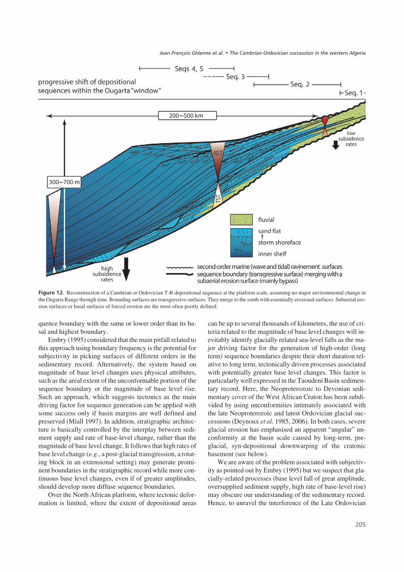
quence boundary with the same or lower order than its ba-
sal and highest boundary.
Embry (1995) considered that the main pitfall related to
this approach using boundary frequency is the potential for
subjectivity in picking surfaces of different orders in the
sedimentary record. Alternatively, the system based on
magnitude of base level changes uses physical attributes,
such as the areal extent of the unconformable portion of the
sequence boundary or the magnitude of base level rise.
Such an approach, which suggests tectonics as the main
driving factor for sequence generation can be applied with
some success only if basin margins are well defined and
preserved (Miall 1997). In addition, stratigraphic architec-
ture is basically controlled by the interplay between sedi-
ment supply and rate of base-level change, rather than the
magnitude of base level change. It follows that high rates of
base level change (e.g., a post-glacial transgression, a rotat-
ing block in an extensional setting) may generate promi-
nent boundaries in the stratigraphic record while more con-
tinuous base level changes, even if of greater amplitudes,
should develop more diffuse sequence boundaries.
Over the North African platform, where tectonic defor-
mation is limited, where the extent of depositional areas
can be up to several thousands of kilometres, the use of cri-
teria related to the magnitude of base level changes will in-
evitably identify glacially related sea-level falls as the ma-
jor driving factor for the generation of high-order (long
term) sequence boundaries despite their short duration rel-
ative to long term, tectonically driven processes associated
with potentially greater base level changes. This factor is
particularly well expressed in the Taoudeni Basin sedimen-
tary record. Here, the Neoproterozoic to Devonian sedi-
mentary cover of the West African Craton has been subdi-
vided by using unconformities intimately associated with
the late Neoproterozoic and latest Ordovician glacial suc-
cessions (Deynoux et al. 1985, 2006). In both cases, severe
glacial erosion has emphasised an apparent “angular” un-
conformity at the basin scale caused by long-term, pre-
glacial, syn-depositional downwarping of the cratonic
basement (see below).
We are aware of the problem associated with subjectiv-
ity as pointed out by Embry (1995) but we suspect that gla-
cially-related processes (base level fall of great amplitude,
oversupplied sediment supply, high rate of base-level rise)
may obscure our understanding of the sedimentary record.
Hence, to unravel the interference of the Late Ordovician
%$
%�����&(' Reconstruction of a Cambrian or Ordovician T-R depositional sequence at the platform scale, assuming no major environmental change in
the Ougarta Range through time. Bounding surfaces are transgressive surfaces. They merge to the south with essentially erosional surfaces. Subaerial ero-
sion surfaces or basal surfaces of forced erosion are the most often poorly defined.
����������� ������� ��������� �!"�����#�$%����� ���� �������&� ����'�(����
glaciation on the Lower Palaeozoic stratigraphic succes-
sion, we need a sequence hierarchy independent of base
level change, and that is why we have used and advocate a
system based on frequency hierarchy to delineate
depositional sequences.
.�������� �����
Sequence boundaries correspond to erosional truncations
that evolve basinward in essentially conformable surfaces
with no demonstrable erosion. Whereas erosion confi-
dently reflects local conditions where rate of sea-level fall
exceeds subsidence rate, the contribution to erosion of
subaerial processes relative to marine ones is unclear. In
particular, shallow-marine facies bracket several erosion
surfaces and any lowstand valleys have been identified.
Moreover, any or minor fluvial deposits have been report-
ed in the basal part of transgressive system tracts (Fig. 8).
An additional feature of the depositional sequences is the
considerable spatial extent of the sand-bodies, with minor
variations in facies occurring over distances > 100 km.
Given that subsidence rates over the platform were of
the same order as low-frequency sea-level fluctuation
rates, i.e. several tens of metres per million years (e.g., Haq
et al. 1987), a transition from relative rise to relative fall
occurred on the platform and migrated through time. Dur-
ing periods of long-term sea-level fall, the extent of areas
experiencing base-level fall conditions progressively in-
creased (e.g., Catuneanu et al. 1998). These areas include
logically proximal southern areas but also some so-called
“basement highs” that are laterally adjacent to “deposi-
tional troughs”. Both types of area correspond to zones of
lesser subsidence favouring the erosion of previously de-
posited shoreface sands during high-frequency transgres-
sions and regressions characterised by higher amplitude
and rate of sea-level change. This cannibalization progres-
sively feeds in clastics deeper and more subsiding portions
of the platform. When the emersion occurred, erosion vir-
tually ceased. Even in front of the established fluvial sys-
tem, the subaerial unconformity should not have been in-
cised and is mainly related to sediment bypass (Runkel etal. 1998, Posamentier 2001). Thus it can be speculated that
erosion was preferentially associated with shoreface ero-
sion processes rather than with fluvial incision. Long-term
normal regression and continuous sedimentation was
maintained in the areas with greater subsidence rates,
where the effects of high-frequency erosional processes
were minimum. This finally resulted in the formation of an
extensive but fully diachronous regressive sand-sheet char-
acterising sediment spreading through a long-term cycle in
the context of this huge and very flat platform. If the shore-
line was located in a sufficiently subsiding area, no long-
term forced regression can have developed as aggrading
conditions pertain throughout a full cycle of sea-level
change.
Runkel et al. (1998) suggested that the formation of
sandstone sheets reflected deposition of a continuous sedi-
ment supply of sand on a relatively stable, nearly flat basin
of slow uniform subsidence during changes in sea level. In-
dependently of possible true basement uplifts, architecture
of depositional sequences in the Ougarta moreover sug-
gests a general redistribution of the sediment during a pe-
riod of low-frequency regressive system tract that might
have a widespread geographic extent, displaying similar
but diachronous facies successions with regressive and
transgressive high-frequency wave reworking of the more
shallow reaches of the platform (proximal areas and “base-
ment highs”). Potential, if any, features related to subaerial
processes were reworked during the subsequent transgres-
sion. The significance of aeolian processes acting on these
surfaces is questioned (Fabre 1988). In particular,
transgressive sand-rich lithologies may be ascribed to a
generalised bypass of the finer-grained material or to the
reworking of continental aeolian sand seas, the sand-domi-
nated material of which is easily wave-reworked and
spread over the platform in the form of huge sand flats.
������ % � �������
The Cambrian-Ordovician succession in the Ougarta
Range records well organised, possibly periodic, stratigrap-
hic cycles. The basin location, above a paleomargin of the
stable West African Craton, which was reactivated during
the later stages of the Pan-African orogeny (cf. Geological
setting), probably favours a relatively regular subsiding
pattern, more active than that characterising adjacent in-
tracratonic domains (e.g., the Taoudeni Basin), but less af-
fected by tectonics than in recently cratonised areas (e.g.,the Tuareg shield, Fig. 1) where fault reactivations may
have periodically and significantly altered the record of
sea-level changes. A long-lasting subsidence pattern and a
continuously rising eustatic sea level during the Ordovi-
cian as recognised worldwide (Ross & Ross 1992, Nielsen
2004, Haq & Al-Qahtani 2005) led to the progressive flood-
ing of the cratonic platform (Fabre 1988, Fabre & Kazi-
Tani 2005). Low frequency depositional sequences, the ti-
ming of which is more or less synchronous at least at the
scale of the North Gondwana domain (e.g., Sharland et al.2001, Haq & Al-Qahtani 2005, Dabard et al. 2007), may
record either second order tectono-eustatic cycles or defor-
mation processes at the continent scale. Deformation pro-
cesses involving the whole of the North African Platform
may correspond to the response of the internal continental
domain to rifting events occurring at the continental mar-
gin. For example, transgressive trends pointing out the
lower part of depositional sequences may reflect extensio-
%$!
����������� ������ �������������
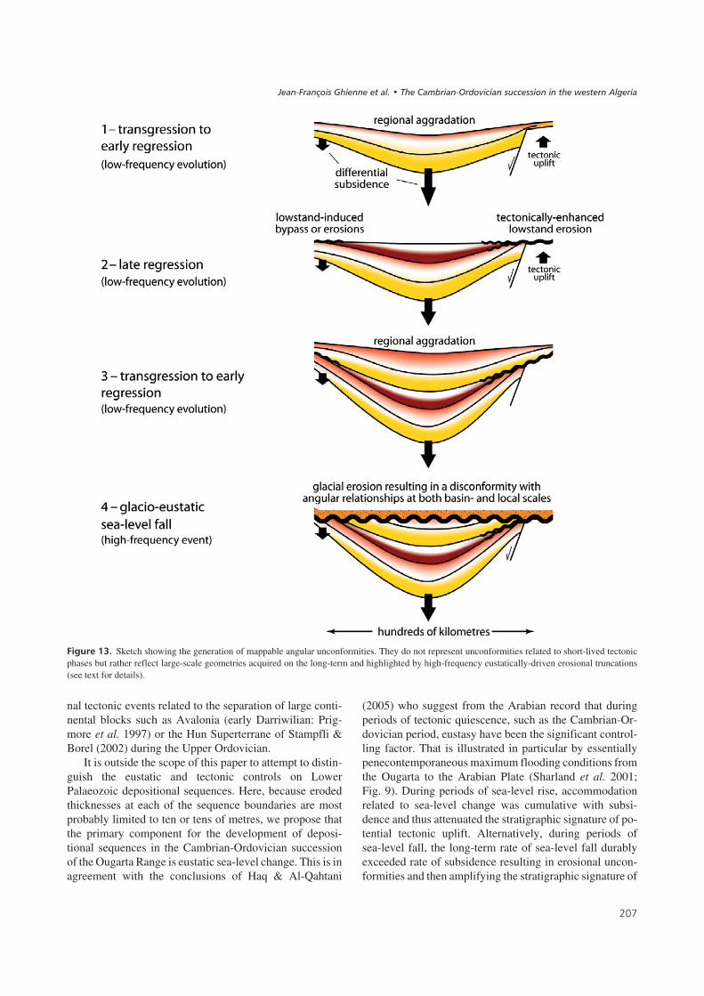
nal tectonic events related to the separation of large conti-
nental blocks such as Avalonia (early Darriwilian: Prig-
more et al. 1997) or the Hun Superterrane of Stampfli &
Borel (2002) during the Upper Ordovician.
It is outside the scope of this paper to attempt to distin-
guish the eustatic and tectonic controls on Lower
Palaeozoic depositional sequences. Here, because eroded
thicknesses at each of the sequence boundaries are most
probably limited to ten or tens of metres, we propose that
the primary component for the development of deposi-
tional sequences in the Cambrian-Ordovician succession
of the Ougarta Range is eustatic sea-level change. This is in
agreement with the conclusions of Haq & Al-Qahtani
(2005) who suggest from the Arabian record that during
periods of tectonic quiescence, such as the Cambrian-Or-
dovician period, eustasy have been the significant control-
ling factor. That is illustrated in particular by essentially
penecontemporaneous maximum flooding conditions from
the Ougarta to the Arabian Plate (Sharland et al. 2001;
Fig. 9). During periods of sea-level rise, accommodation
related to sea-level change was cumulative with subsi-
dence and thus attenuated the stratigraphic signature of po-
tential tectonic uplift. Alternatively, during periods of
sea-level fall, the long-term rate of sea-level fall durably
exceeded rate of subsidence resulting in erosional uncon-
formities and then amplifying the stratigraphic signature of
%$"
%�����&)' Sketch showing the generation of mappable angular unconformities. They do not represent unconformities related to short-lived tectonic
phases but rather reflect large-scale geometries acquired on the long-term and highlighted by high-frequency eustatically-driven erosional truncations
(see text for details).
����������� ������� ��������� �!"�����#�$%����� ���� �������&� ����'�(����
potential tectonic uplift. Mappable angular unconformities
can appear in areas where differential subsidence rates ex-
isted prior to erosion (Fig. 13). They do not represent un-
conformities related to short-lived tectonic phases but
large-scale geometries acquired on the long-term and high-
lighted by eustatically-driven erosional truncation corre-
sponding to composite, amalgamated, subaerial or trans-
gressive erosion surfaces during repeated high-frequency
to short-term sea-level fluctuations. The more the ampli-
tude of eustatic sea-level fall, the falsely greater the appar-
ent tectonic event will appear (Fig. 13). Nevertheless, out-
side the Ougarta, localised but significant deformation
events did occur close to Pan-African lineaments in re-
sponse to stress at the continental margin. Such uplifts are
well known in Algeria, where there might have resulted
from the superimposition of Dapingian or early
Darriwilian (i.e. Upper Arenig) strata on Tremadocian via
an erosion surface (e.g., Oulebsir & Paris 1995). In the
Ahnet area, Beuf et al. (1971) have demonstrated that these
uplifts were located above lithospheric structures prone to
be reactivated.
/�����������+��"����������
From the Cambrian to Late Ordovician, successive deposi-
tional sequences show: (1) progressive disappearance of
fluvial facies; (2) thinning of transgressive system tracts;
and (3) development of repetitive open marine conditions
from the lower part of sections onwards and from the NW
to the SE Ougarta. These relationships that designate ret-
rogradational architecture on the long term indicate that
the Cambrian-Ordovician succession corresponds to a
first-order transgressive system resulting in a step-by-step
flooding of the North African Platform. This view do not
support the Sharland et al. (2001) stratigraphic scheme,
within which the Cambrian-Ordovician succession repre-
sents as a whole a single tectono-stratigraphic sequence.
The preservation of this thick transgressive system,
though deposited in the context of a continuously rising
eustatic sea level, implies in addition the progressive
southeastward migration of the depositional edge from the
Cambrian to the Ordovician. While a continuously subsid-
ing platform occurred toward the north (e.g., Anti-Atlas),
subsidence was initiated in progressively more and more
southern areas with differential subsidence patterns, con-
trasting depositional troughs and basement highs. Timing
of this overall onlap relationship of Cambrian-Ordovician
strata on the basement is supported by biostratigraphy and
provenance studies. First, open marine conditions reached
the most internal areas of the platform only during the Up-
per Ordovician. Near the Algeria-Mali boundary, i.e.600 km south of the Ahnet area (right section in Fig. 10),
Gatinski et al. (1966) documented the occurrence of
biostratigraphically dated Upper Ordovician deposits bear-
ing graptolites, trilobites and brachiopods above a thin
(< 20 m) cross-stratified barren sandstone unit resting on
the Neoproterozoic basement. Second, studies based on de-
trital zircons show that those of Pan-African age are pre-
dominant in Cambrian strata (matching the more arkosic
nature of the sandstones) whereas they progressively dis-
appear in parallel with the significant increase in propor-
tion of zircons with older ages (> 1Ga). Therefore, the
blanketing of the Pan-African sediment source is inferred
and a many hundreds of kilometres southward migration of
the source area is suggested (Avigad et al. 2003, Kolodner
et al. 2006).
��������+���"�0"�"��������
If the Cambrian-Ordovician succession represents a trans-
gressive system for the North Gondwana Lower Palaeo-
zoic strata, what is the corresponding maximum flooding
surface? (i.e. the stratigraphic surface marking in the long
term the end of the shoreline transgression and separating
retrograding to prograding strata).
It is generally recognised that higher eustatic sea levels
were achieved during the Late, but not the latest, Ordovi-
cian (e.g., Ross & Ross 1992, Nielsen 2004, Haq &
Al-Qahtani 2005). The first-order maximum flooding sur-
face (MFS) representing the culmination of the Cam-
brian-Ordovician shoreline transgression should have been
Late Ordovician or older. Without the incidence of the
Hirnantian glaciation, the Ordovician MFS should have
been coincident with one of the second-order maximum
flooding surfaces between the Middle and the Upper Ordo-
vician, depending on relationships between rates of
long-term sea-level rise and subsidence. Spatial variations
in subsidence may induce stratigraphic sequence distortion
with the onset of progradation delayed in the more subsid-
ing area (Robin et al. 2005). In areas experiencing limited
subsidence (~ 5–10 m/Ma, e.g., the Taoudeni Basin in
Mauritania or the Murzuq Basin in Libya), the Ordovician
MFS might have occurred as early as the lower Middle Or-
dovician (early Darriwilian, i.e. formosa event sensu Paris
et al. 2007 of early Llanvirn age), when rates of sea-level
rise were greater, resulting in a general backstepping of
the shorelines throughout the platform. In more subsiding
areas such as the Ougarta (~ 10–20 m/Ma), or the Anti-At-
las (> 30 m/Ma), the Ordovician MFS may have been nota-
bly younger (Late Ordovician) and have been established
when rate of sea-level rise had already noticeably declined.
However, it must be born in mind that some restrictions to
this oversimplified view such as long-term basinward mi-
gration of the shoreline from an internal and slowly subsid-
ing area, which experienced sediment bypass or reworking,
toward distal faster subsiding areas, most probably forced
%$�
����������� ������ �������������
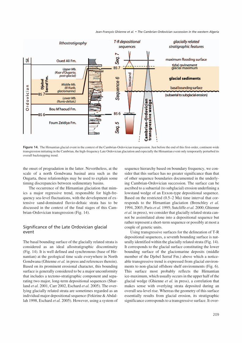
the onset of progradation in the latter. Nevertheless, at the
scale of a north Gondwana basinal area such as the
Ougarta, these relationships may be used to explain some
timing discrepancies between sedimentary basins.
The occurrence of the Hirnantian glaciation that mim-
ics a major regressive trend, responsible for high-fre-
quency sea-level fluctuations, with the development of ex-
tensive sand-dominated fluvio-deltaic strata has to be
discussed in the context of the final stages of this Cam-
brian-Ordovician transgression (Fig. 14).
.�����������������������+��������
�+���
The basal bounding surface of the glacially related strata is
considered as an ideal allostratigraphic discontinuity
(Fig. 14). It is well defined and synchronous (base of Hir-
nantian) at the geological time scale everywhere in North
Gondwana (Ghienne et al. in press and references therein).
Based on its prominent erosional character, this bounding
surface is generally considered to be a major unconformity
that includes a tectono-stratigraphic component and sepa-
rating two major, long-term depositional sequences (Shar-
land et al. 2001, Carr 2002, Eschard et al. 2005). The over-
lying glacially related strata are sometimes regarded as an
individual major depositional sequence (Fekirine & Abdal-
lah 1998, Eschard et al. 2005). However, using a system of
sequence hierarchy based on boundary frequency, we con-
sider that this surface has no greater significance than that
of other sequence boundaries documented in the underly-
ing Cambrian-Ordovician succession. The surface can be
ascribed to a subaerial (to subglacial) erosion underlining a
lowstand wedge of an Exxon-type depositional sequence.
Based on the restricted (0.5–2 Ma) time interval that cor-
responds to the Hirnantian glaciation (Brenchley et al.1994, 2003; Paris et al. 1995; Sutcliffe et al. 2000; Ghienne
et al. in press), we consider that glacially related strata can-
not be assimilated alone into a depositional sequence but
rather represent a short-term sequence or possibly at most a
couple of genetic units.
Using transgressive surfaces for the delineation of T-R
depositional sequences, a seventh bounding surface is nat-
urally identified within the glacially related strata (Fig. 14).
It corresponds to the glacial surface constituting the lower
bounding surface of the glaciomarine deposits (middle
member of the Djebel Serraf Fm.) above which a notice-
able transgressive trend is expressed from glacial environ-
ments to non-glacial offshore shelf environments (Fig. 6).
This surface most probably reflects the Hirnantian
ice-maximum, which usually occurs in the upper half of the
glacial wedge (Ghienne et al. in press), a correlation that
makes sense with overlying strata deposited during an
overall sea-level rise. Whereas the geometry of this surface
essentially results from glacial erosion, its stratigraphic
significance corresponds to a transgressive surface. It over-
%$#
%�����&-' The Hirnantian glacial event in the context of the Cambrian-Ordovician transgression. Just before the end of this first-order, continent-wide
transgression initiating in the Cambrian, the high-frequency Late Ordovician glaciation and especially the Hirnantian event only temporarily perturbed its
overall backstepping trend.
����������� ������� ��������� �!"�����#�$%����� ���� �������&� ����'�(����
lies fluvio-deltaic deposits at the top of the regressive sys-
tem tract of the sixth depositional sequence and then forms
the basal bounding surface of a seventh T-R depositional
sequence.
Similar relationships, attributing the younger Hirnan-
tian glacial strata to a transgressive system tract extending
in the Silurian have also been described from the glacial re-
cord in Mauritania (Ghienne 2003). A maximum flooding
surface can be pointed out for this seventh sequence in the
lowermost Silurian (Lüning et al. 2000, surface S10 of
Sharland et al. 2001), a time interval from which the shore-
line renewed to migrate northward and even if deepening
conditions were maintained northward by a low rate of off-
shore transport and locally by subsidence patterns. The
seventh depositional sequence further includes the overly-
ing Silurian strata, which correspond throughout North
Gondwana to a well known prograding wedge (Bellini &
Massa 1980, Lüning et al. 2000, Eschard et al. 2005) con-
stituting its regressive system tract.
The Hirnantian glaciation has been responsible for: (i)
considerable basal erosion, affecting the whole of the plat-
form, with erosion depths in places greater than 300 m
(Ghienne et al. in press, and references therein); (ii) the
onset of continental conditions, either fluvial or subglacial,
which arose quite instantaneously throughout the platform
with sedimentation directly influenced by glaciers recog-
nised from the Anti-Atlas to Southern Algeria; and (iii)
very high rates of sea-level change, both within and at the
end of the glaciation (post-glacial transgression). The gla-
cial erosion, which was deeper and faster than all other
preglacial erosion processes, led to a stratigraphic disconti-
nuity along which latest Ordovician rests at first-order on
progressively older strata toward the south (Fig. 10); Upper
Ordovician to the north of the platform (e.g., Destombes
1968a, b, Bourahrouh et al. 2004), then Middle and Lower
Ordovician in intermediate areas (e.g., Oulebsir & Paris
1995) and then Cambrian or basement rocks southwards
(Beuf et al. 1971). The discontinuity, angular at the basin
scale, truncates noticeably older basin-wide or localised
syn-depositional deformation structures, falsely suggest-
ing a major tectonic deformation event, sometimes related
to the so-called Taconic unconformity, which would have
occurred just prior to glaciation onset (e.g., Crossley &
McDougall 1998, Eschard et al. 2005). For example, in a
number of areas located between the Ahnet and the
Ougarta (figured by an oversimplified horst structure in
Fig. 10), glacial strata rest on Lower Ordovician or Cam-
brian strata (Legrand 1985). This unconformable contact,
highlighted by glacial erosion, is regarded as mainly re-
flecting deformation structures that affected deposition
during the late Early Ordovician (Beuf et al. 1971; Fig. 13).
In our scheme, there is no reason to attribute any tec-
tono-stratigraphic value to the basal bounding surface of
the glacially related strata.
The subsequent post-glacial transgression, which was
very fast relative to the Cambrian-Ordovician tempo, re-
sulted in a non-accretionary transgression (e.g., Helland-
Hansen & Gjellberg 1994) with a drastic southward
backstepping of the shoreline during which post-glacial
sedimentation dominated over the main part of the plat-
form with in-situ wave or tidal reworking (Fig. 7; e.g.,
Ghienne 2003, Moreau 2005). As a consequence, the com-
bination of glacial erosion and post-glacial high rate of
sea-level rise forced shorelines to shift drastically to the
south. Early Silurian shorelines reach the south of the
Koufra Basin (Libya-Chad boundary; Lüning et al. 2000),
and were located south of the Djado area in Niger (Legrand
2003, Denis et al. 2007) or to the SE of the Hodh area in
Mauritania (Paris et al. 1998, Ghienne 2003). From these
southern locations, Silurian shorelines have then migrated
throughout the platform to the NW (Bellini & Massa 1980,
Lüning et al. 2000).
�����������
The Silurian flooding on the North Gondwana platform may
be regarded as the end product of the Cambrian-Ordovician
transgression, with specific features enhanced by the
high-frequency Hirnantian glacial event. High sea levels of
the Late Ordovician period were abruptly restored on the
platform with latest Ordovician shorelines shifted sout-
hward relative to all other Late Ordovician shorelines. The
global and virtually instantaneous nature of the Hirnantian
glacial event has “synchronised” the stratigraphic architec-
ture of the succession throughout the platform. At the end of
the post-glacial transgression, a second-order maximum flo-
oding occurred everywhere, whatever the local rate of subsi-
dence, near the Ordovician-Silurian boundary or more pro-
bably within the earliest Silurian. This event, which also
marks the first-order inversion trend between generally ret-
rograding strata of the Cambrian-Ordovician succession and
a prograding Siluro-Devonian wedge, corresponds to the
maximum flooding of the Lower Palaeozoic transgres-
sive-regressive megasequence in North Africa. Just before
the end of this first-order, continent-wide transgression initi-
ating in the Cambrian, the Late Ordovician glaciation, and
especially the Hirnantian event, only temporarily perturbed
its overall backstepping trend.
��6������������
The authors are indebted to the SONATRACH (Algerian Na-
tional Oil Company) for logistic and scientific support during
fieldwork in the Algerian Sahara. One of us (B.V.) benefited from
a post-doctoral grant from TOTAL S.A. The authors are grateful
to J. Frýda, M. Mergl and P. Štorch (Czech Republic) as well as
%�$
����������� ������ �������������
E. Villas (Spain), M. Vidal and J. Vannier (France) for prelimi-
nary faunal identifications. They also thank O. Fatka, P. Kraft and
O.E. Sutcliffe, for reviewing and greatly improving the manu-
script. This is a contribution of EOST (Ecole et Observatoire des
Sciences de la Terre) number 2007.501 – UMR 7517 to the
ECLIPSE II (CNRS, France) and to IGCP 503 projects.
���������
ALBANI, R., MASSA, D. & TONGIORGI, M. 1991. Palynostrati-
graphy (Acritarchs) of some Cambrian beds from the Rhadames
(Ghadamis) Basin (Western Libya–Southern Tunisia). Bolletinodella Società Paleontologica Italiana 30, 255–280.
ÁLVARO, J.J., VAN VLIET-LANOË, B., VENNIN, E. & BLANC-VAL-
LERON, M.M. 2003a. “Lower” Cambrian paleosols from the
Cantabrian Mountains (northern Spain): a comparison with Neo-
gene-Quaternary analogues. Sedimentary Geology 163, 67–84.
ÁLVARO, J.J., GONZÁLEZ-GÓMEZ, C. & VIZCAÏNO, D. 2003b.
Paleogeographic patterns of the Cambrian-Ordovician transition
in the southern Montagne Noire (France): preliminary results.
Bulletin de la Société géologique de France 174/3, 23–31.
ARBEY, F. 1962. Données nouvelles sur la sédimentation au Cam-
bro-Ordovicien dans les Monts d’Ougarta (Saoura). Comptesrendus de l’Académie des sciences, Paris 254, 3726–3728.
ARBEY, F. 1968. Structures et dépôts glaciaires dans l’Ordovicien
terminal des chaînes d’Ougarta (Sahara algérien). Comptesrendus de l’Académie des sciences, Paris 268, 76–78.
ARBEY, F. 1971. Glacio-tectonique et phénomènes périglaciaires
dans les dépôts siluro-ordoviciens des monts d’Ougarta (Sahara
algérien). Comptes rendus de l’Académie des sciences, Paris273, 854–857.
ARBEY, F. 1988. Diagénèses précoces et tardives: silicifications etroches silico-détritiques. 521 pp. Thèse de doctorat d’état,
Université de Paris-Sud, France.
ARBEY, F. & CABY, R. 1966. Présence de dreikanters à la base du
Cambrien de la Sebkha el Melah; remarques sur la discordance
du Paléozoïque et sur l’âge du soubassement dans la région des
Monts d’Ougarta (Sahara algérien). Comptes rendus sommairesde la Société géologique de France, 63–64.
AVIGAD, D., KOLODNER, K., MCWILLIAMS, M., PERSING, H. &
WEISSBROD, T. 2003. Origin of northern Gondwana Cambrian
sandstone revealed by detrital zircon SHRIMP dating. Geology31, 227–230.
AVIGAD, D., SANDLER, A., KOLODNER, K., STERN, R.J., MCWIL-
LIAMS, M., MILLER, N. & BEYTH, M. 2005. Mass-production of
Cambro-Ordovician quartz-rich sandstone as a consequence of
chemical weathering of Pan-African terranes: environmental im-
plications. Earth and Planetary Science Letters 240, 818–826.
BELLINI, E. & MASSA, D. 1980. A stratigraphic contribution to the Pa-
leozoic of the Southern Basins of Libya, 1–56. In SALEM, M.J. &
BUSWELL, M.T. (eds) Geology of Libya I. Academic Press, London.
BENOÎT, A. & TAUGOURDEAU, P. 1961. Sur quelques chitinozoaires
de l’Ordovicien du Sahara. Revue de l’Institut Français duPétrole 16, 1403–1421.
BEUF, S., BIJU-DUVAL, B., DE CHARPAL, O., ROGNON, P., GARIEL,
O. & BENNACEF, A. 1971. Les grès du Paleozoïque inférieur auSahara. 464 pp. Science et Technique du Pétrole 18, Paris.
BOOTE, D.R.D., CLARK-LOWES, D.D. & TRAUT, M.W. 1998.
Paleozoic petroleum systems of North Africa, 7–68. InMACGREGOR, D.S., MOODY, R.T.J. & CLARK-LOWES, D.D.
(eds) Petroleum Geology of North Africa, Geological SocietyLondon Special Publication 132.
BOURAHROUH, A., PARIS, F. & ELAOUAD-DEBBAJ, Z. 2004. Bio-
stratigraphy, biodiversity and palaeoenvironments of the chiti-
nozoans and associated palynomorphs from the Upper Ordovi-
cian of the Central Anti-Atlas, Morocco. Palaeogeography,Palaeoclimatology, Palaeoecology 130, 17–40.
BRENCHLEY, P.J., ROMANO, M. & GUTIÉRREZ-MARCO, J.C. 1986.
Proximal and distal hummocky cross-stratification facies on a
wide Ordovician shelf in Iberia, 241–255. In KNIGHT, R.J. &
MCLEAN, J.R. (eds) Shelf sands and sandstones. Memoir Cana-dian Society Petroleum Geologists II.
BRENCHLEY, P.J., MARSHALL, J.D., CARDEN, G.A.F.,
ROBERTSON, D.B.R., LONG, D.G.F., MEIDLA, T., HINTS, L. &
ANDERSON, T.F. 1994. Bathymetric and isotopic evidence for a
short-lived Late Ordovician glaciation in a greenhouse period.
Geology 22, 295–298.
BRENCHLEY, P.J., CARDEN, G.A., HINTS, L., KALJO, D., MAR-
SHALL, J.D., MARTMA, T., MEIDLA, T. & NOLVAK, J. 2003.
High-resolution stable isotope stratigraphy of Upper Ordovician
sequences: Constraints on the timing of bioevents and environ-
mental changes associated with mass extinction and glaciation.
Bulletin of the Geological Society of America 115, 89–104.
BURKE, K. & KRAUS, J.U. 2000. Deposition of immense Cambro-
Ordovician sandstone bodies, now exposed mainly in north Af-
rica and Arabia, during the aftermath of the final assembly of
Gondwana. Geological Society of America Abstracts with Pro-gram 32(7), 249.
BURKHARD, M., CARITG, S., HELG, U., ROBERT-CHARRUE, C. &
SOULAIMANI, A. 2006. Tectonics of the Anti-Atlas of Morocco.
Comptes Rendus Geosciences 338, 11–24.
CABY, R. 1996. Rapport de mission de terrain dans le Grand
Sud-Ouest Algérien. Mémoires du Service géologique d’Algérie8, 49–51.
CARR, I.D. 2002. Second-order sequence stratigraphy of the Palaeo-
zoic of North Africa. Marine Petroleum Geology 25, 259–280.
CATUNEANU, O. 2002. Sequence stratigraphy of clastic systems:
concepts, merits, and pitfalls. Journal of African Earth Science35, 1–43.
CATUNEANU, O., WILLIS, A.J. & MIALL, A.D. 1998. Temporal sig-
nificance of sequence boundaries. Sedimentary Geology 121,
157–178.
CLIFTON, H.E. 1976. Wave-formed sedimentary structures – a
conceptual model, 126–148. In DAVIS, R.A., JR. & ETHING-
TON, R.L. (eds) Beach and Nearshore Sedimentation. Societyof Economic Paleontogists and Mineralogists, Special Publi-cation 24.
CROSSLEY, R. & MCDOUGALL, N. 1998. Lower Palaeozoic reser-
voirs of North Africa, 157–166. In MACGREGOR, D.S., MOODY,
R.T.J. & CLARK-LOWES, D.D. (eds) Petroleum Geology of NorthAfrica. Geological Society London Special Publication 132.
DABARD, M.P., LOI, A. & PARIS, F. 2007. Relationship between
phosphogenesis and sequence architecture: sequence stratigra-
phy and biostratigraphy in the Middle Ordovician of the Armori-
can Massif (W France). Palaeogeography, Palaeoclimatology,Palaeoecology 248, 339–356.
%��
����������� ������� ��������� �!"�����#�$%����� ���� �������&� ����'�(����
DEAN, W.T. 2005. Trilobites from the Cal Tepe Formation (Cam-
brian), near Seydisehir, Central Taurides, south-western Turkey.
Turkish Journal of Earth Sciences 13, 1–71.
DEAN, W.T. & MONOD, O. 1990. Revised stratigraphy and relation-
ships of Lower Palaeozoic rocks, eastern Taurus Mountains,
south central Turkey. Geological Magazine 127, 333–347.
DENIS, M., BUONCRISTIANI, J.-F., KONATÉ, M., GHIENNE, J.-F. &
GUIRAUD, M. 2007. Hirnantian glacial and deglacial record in
SW Djado Basin (NE Niger). Geodinamica Acta 20(3), 177–194.
DESTOMBES, J. 1968a. Sur la présence d’une discordance générale
de ravinement d’âge Ashgill supérieur dans l’Ordovicien termi-
nal de l’Anti-Atlas (Maroc). Comptes rendus de l’Académie dessciences, Paris 267 D, 565–567.
DESTOMBES, J. 1968b. Sur la nature glaciaire des sédiments du groupe
du 2e
Bani, Ashgill supérieur de l’Anti-Atlas, Maroc. Comptesrendus de l’Académie des sciences, Paris 267 D, 684–686.
DESTOMBES, J. & FEIST, R. 1987. Découverte du Cambrien
supérieur en Afrique (Anti-Atlas, Maroc). Comptes rendus del’Académie des sciences, Paris 304, 719–724.
DESTOMBES, J., HOLLART, H. & WILLEFERT, S. 1985. Lower Pa-
leozoic rocks of Morocco, 291–325. In HOLLAND, C.H. (ed.)
Lower Paleozoic Rocks of northwest and west Central Africa.
John Wiley, New York.
DEYNOUX, M. 1985. Terrestrial or waterlain glacial diamictites?
Three case studies from the Late Precambrian and Late Ordovi-
cian glacial drifts in West Africa. Palaeogeography,Palaeoclimatology, Palaeoecology 51, 97–141.
DEYNOUX, M., SOUGY, J. & TROMPETTE, R. 1985. Lower Paleozoic
rocks of West Africa and the western part of Central Africa,
337–495. In HOLLAND, C.H. (ed.) Lower Paleozoic Rocks ofnorthwest and west Central Africa. John Wiley, New-York.
DEYNOUX, M. & GHIENNE, J.-F. 2004. Late Ordovician glacial
pavements revisited – a reappraisal of the origin of striated sur-
faces. Terra Nova 16, 95–101.
DEYNOUX, M., AFFATON, P., TROMPETTE, R. & VILLENEUVE, M.
2006. Pan-African tectonic evolution and glacial events regis-
tered in Neoproterozoic to Cambrian cratonic and foreland basins
of West Africa. Journal of African Earth Science 46, 397–426.
DONZEAU, M. 1971. Etude structurale dans le Paléozoïque desMonts d’Ougarta. 100 pp. Thèse de doctorat, Faculté des Sci-
ences, Orsay, France.
DONZEAU, M. 1974. L’Arc Anti-Atlas – Ougarta (Sahara nord-occi-
dental, Algérie-Maroc). Comptes rendus de l’Académie des sci-ences, Paris 278, 417–420.
DONZEAU, M. 1983. Tectonique des monts d’Ougarta, 118–120. InFABRE, J. (ed.) Afrique de l’Ouest, Introduction Géologique ettermes stratigraphiques. Lexique stratigraphique international,Nouvelle série 1. Pergamon Press, Oxford.
DUMAS, S. & ARNOTT, R.W.C. 2006. Origin of hummocky and
swaley cross-stratification – The controlling influence of unidi-
rectional current strength and aggradation rate. Geology 34,
1073–1076.
ELAOUAD-DEBBAJ, Z. 1987. Acritarches et Chitinozoaires del’Ordovicien du Maroc. Systématique, Biostratigraphie, corré-lations. 310 pp. Thèse de doctorat, Université de Rennes I (un-
published).
ELAOUAD-DEBBAJ, Z. 1988. Acritarches et chitinozoaires du Tre-
madoc de l’Anti Atlas central (Maroc). Revue de micropa-léontologie 31, 85–128.
EMBRY, A.F. 1995. Sequence boundaries and sequences hierarchies:
problems and proposals, 1–11. In STEEL, R.J., FELT, V.L.,
JOHANNESEN, E.P. & MATHIEU, C. (eds) Sequence stratigraphyon the Northwest European Margin. Norwegian Petroleum Soci-ety, Special Publication 5.
ENNIH, N. & LIÉGEOIS, J.-P. 2001. The Moroccan Anti-Atlas: the
West African passive margin with limited Pan-African activity.
Precambrian Research 112, 289–302.
ESCHARD, R., ABDALLAH, H., BRAIK, F. & DESAUBLIAUX, G.
2005. The Lower Paleozoic succession in the Tasilli outcrops,
Algeria: sedimentology and sequence stratigraphy. First Break23, 27–36.
FABRE, J. 1988. Les séries paléozoïques d’Afrique: une approche.
Journal of African Earth Science 7, 1–40.
FABRE, J. 2005. Le Précambrien terminal – Cambrien: glaciation et
enterrement d’une chaîne panafricaine, 117–144. In FABRE, J.
(ed.) Géologie du Sahara occidental et central. Tervuren AfricanGeoscience Collection 108. Musée Royal de l’Afrique Centrale,
Tervuren.
FABRE, J. & KAZI-TANI, N. 2005. Ordovicien, Silurien, Devonien,
Permo-Carbonifère, 147–360. In FABRE, J. (ed.) Géologie du Sa-hara occidental et central. Tervuren African Geoscience Collec-tion 108. Musée Royal de l’Afrique Centrale, Tervuren.
FABRE, J., AIT-KACI, A., BOUIMA, T. & MOUSSINE-POUCHKINE,
A. 1988. Le cycle molassique dans le rameau trans-saharien de la
chaîne panafricaine. Journal of African Earth Science 7, 41–55.
FAIK, F., BELFOUL, M.A., BOUABDELLI, M. & HASSENFORDER, B.
2001. Les structures de la couverture Néoprotérozoïque terminal
et Paléozoïque de la region de Tata, Anti-Atlas centre occidental,
Maroc: deformation polyphasée, ou interactions socle/couverture
pendant l’orogenèse hercynienne. Journal of African Earth Sci-ence 32, 765–776.
FEKIRINE, B. & ABDALLAH, H. 1998. Palaeozoic lithofacies correla-
tives and sequence Stratigraphy of the Sahara Platform, Algeria,
97–108. In MACGREGOR, D.S., MOODY, R.T.J. & CLARK-LO-
WES, D.D. (eds) Petroleum Geology of North Africa. GeologicalSociety London Special Publication 132.
GATINSKI, G., KLOTCHKI, V.P., ROZMAN, K.S. & TROFIMOV, D.M.
1966. Nouvelles données sur la stratigraphie des dépôts
paléozoïques du Sahara méridional. Doklady Akademii naukSSSR 170, 1154–1157.
GHIENNE, J.-F. 2003. Late Ordovician sedimentary environments,
glacial cycles, and post-glacial transgression in the Taoudeni Ba-
sin, West Africa. Palaeogeography, Palaeoclimatology, Palaeo-ecology 189, 117–145.
GHIENNE, J.-F. & DEYNOUX, M. 1998. Large-scale channel fill
structures in Late Ordovician glacial deposits in Mauritania,
western Sahara. Sedimentary Geology 119, 141–159.
GHIENNE, J.-F., LE HERON, D., MOREAU, J., DENIS, M. &
DEYNOUX, M. In press. The Late Ordovician glacial sedimentary
system of the North Gondwana platform. In HAMBREY, M.,
CHRISTOFFERSEN, P., GLASSER, N., JANSSEN, P., HUBBARD, B.
& SIEGERT, M. (eds) Glacial sedimentary processes and prod-ucts. International Association of Sedimentologists, Special Pub-lication 39. Blackwells, Oxford.
GOMEZ SILVA, M., PACAUD, M. & WIEL, F. 1963. Contribution à
l’étude du Cambro-Ordovician des chaînes d’Ougarta (Sahara
algérien). Bulletin de la Société géologique de France 7,
134–141.
%�%
����������� ������ �������������
GUTIÉRREZ-MARCO, J.C., DESTOMBES, J., RÁBANO, I., ACEÑOLAZA,
G.F., SARMIENTO, G.N. & SAN JOSÉ, M.A. 2003. El Ordovícico
Medio del Anti-Atlas marroquí: paleobiodiversidad, actualización
bioestratigráfica y correlación. Geobios 36, 151–177.
HAMPSON, G.J. 2000. Discontinuity surfaces, clinoforms, and facies
architecture in a wave-dominated, shoreface-shelf parasequence.
Journal of Sedimentary Research 70, 325–340.
HAQ, B.U. & AL-QAHTANI, A.M. 2005. Phanerozoic cycles of
sea-level change on the Arabian Platform. GeoArabia 10,
127–160.
HAQ, B.U., HARDENBOL, J. & VAIL, P.R. 1987. Chronology of fluc-
tuating seal levels since the Triassic. Science 235, 1156–1166.
HARMS, J.C., SOUTHARD, J.B. & WALKER, R.G. 1982. Structures
and sequences in clastics rocks. Society for Sedimentary Geology(SEPM) Short Course 9, 1–253.
HART, B.S. & PLINT, A.G. 1989. Gravelly shoreface deposits; a
comparaison of modern and ancient facies sequences.
Sedimentology 36, 551–557.
HELLAND-HANSEN, W. & GJELLBERG, J.G. 1994. Conceptual basis
and variability in sequence stratigraphy: a different perspective.
Sedimentary Geology 92, 31–52.
HERVOUET, Y. & DUEE, G. 1996. Analyse morphostructurale par
imagerie satellitaire et coupes structurales modélisées des monts
d’Ougarta (Sahara occidental, Algérie): une chaîne hercynienne
chevauchante à plis passifs. Mémoires du Service géologique del’Algérie 8, 127–173.
HIRST, J.P.P., BENBAKIR, A., PAYNE, D.F. & WESTLAKE, I.R. 2002.
Tunnel valleys and density flow processes in the upper Ordovi-
cian glacial succession, Illizi Basin, Algeria: influence on reser-
voir quality. Marine Petroleum Geology 25, 297–324.
KICHOU-BRAÎK, F., SAMAR, L., FEKIRINE, B. & LEGRAND, P. 2006.
Découverte de graptolites d’âge Caradocien dans quelques
sondages du Tinrhert (Sahara algérien). Comptes Rendus Palevol5(5), 675–683.
KILIAN, C. 1922. Aperçu général de la structure des Tassilis, des
Ajjers. Comptes rendus de l’Académie des sciences, Paris 175,
825–827.
KOLODNER, K., AVIGAD, D., MCWILLIAMS, M., WOODEN, J.L.,
WEISSBROD, T. & FEINSTEIN, S. 2006. Provenance of north
Gondwana Cambrian-Ordovician sandstone: U-Pb. SHRIMP
dating of detrital zircons from Israel and Jordan. GeologicalMagazine 143, 367–391.
LANDING, E., GEYER, G. & HELDMAIER, W. 2006. Distinguishing
eustatic and epeirogenic controls on Lower-“Middle” Cambrian
boundary successions in West Gondwana (Morocco and Iberia).
Sedimentology 54, 899–918.
LASKAR, J. 1999. The limits of Earth orbital calculations for geolog-
ical time-scale use. Philosophical Transactions of the Royal Soci-ety of London A 357, 1735–1759.
LECKIE, D.A. 1988. Wave-formed, coarse-grained ripples and their
relationship to hummocky cross-stratification. Journal of Sedi-mentary Petrology 58, 607–622.
LEDRU, P., AUTRAN, A. & SANTALLIER, D. 1994. Lithostratigraphy
of Variscan terranes in the French Massif Central: a basis for
paleogeographical reconstruction, 226–288. In KEPPIE, J.D. (ed.)
Pre-Mesozoic geology in France and related areas. Springer,
Berlin.
LE HERON, D.P., SUTCLIFFE, O.E., WHITTINGTON, R.J. & CRAIG, J.
2005. The origins of glacially related soft-sediment deformation
structures in Upper Ordovician glaciogenic rocks: implication for
ice sheet dynamics. Palaeogeography, Palaeoclimatology,Palaeoecology 218, 75–103.
LEGRAND, P. 1964. Un graptolite intéressant de l’Arénigien su-
périeur du Sahara algérien: Didymograptus v-fraactus wieli nov.
subsp. Comptes rendus sommaires de la Société géologique deFrance 9, 360–363.
LEGRAND, P. 1966. Précisions biostratigraphiques sur l’Ordovicien
inférieur et le Silurien des chaînes de l’Ougarta (Sahara algérien).
Comptes rendus sommaires de la Société géologique de France97, 243–245.
LEGRAND, P. 1974. Essai sur la paléogéographie de l’Ordovicien du
Sahara algérien. Compagnie Française des Pétroles, Notes etMémoires 11, 121–138.
LEGRAND, P. 1985. Lower Palaeozoic rocks of Algeria, 5–89. InHOLLAND, C.H. (ed.) Lower Paleozoic Rocks of northwest andwest Central Africa. John Wiley, New York.
LEGRAND, P. 1988. The Ordovician-Silurian boundary in the Alge-
rian Sahara, 139–143. In COCKS, L.R.M. & RICKARDS, R.B.
(eds) A global analysis of the Ordovician-Silurian boundary. Bul-letin of the British Museum (Natural History), Geology 43.
LEGRAND, P. 2003. Paléogeographie du Sahara algérien à
l’Ordovicien terminal et au Silurien inférieur. Bulletin de laSociété géologique de France 174, 19–32.
LEGRAND, P. & NABOS, G. 1962. Contribution à la stratigraphie du
Cambro-Ordovicien dans le bassin saharien occidental. Bulletinde la Société géologique de France 7, 123–131.
LESSERTISSEUR, J. 1971. L’énigme du Daedalus (DaedalusRouault, 1850). Ichnofossilia. Bulletin du Muséum nationald’histoire naturelle (Paris) 20, 37–66.
LONG, D.G.F. 2004. Precambrian rivers, 660–663. In ERIKSSON,
P.G., ALTERMANN, W., NELSON, D.R., MUELLER, W.U. &
CATUNEANU, O. (eds) The Precambrian Earth: Tempos andevents (Developments in Precambrian geology) 12. Elsevier,
Amsterdam.
LÜNING, S., CRAIG, J., LOYDELL, D.K., ŠTORCH, P. & FITCHES, B.
2000. Lower Silurian ‘hot shales’ in North Africa and Arabia: re-
gional distribution and depositional model. Earth-Science Re-views 49, 121–200.
MACNAUGHTON, R.B., DALRYMPLE, R.W. & NARBONNE, G.M.
1997. Early Cambrian braid-delta deposits, MacKenzie Moun-
tains, north-western Canada. Sedimentology 44, 587–609.
MENCHIKOFF, N. 1933. La série primaire de la Saoura et des chaînes
d’Ougarta. Bulletin du Service de la Carte géologique d’Algérie11, 109–123.
MIALL, A.D. 1997. The geology of stratigraphic sequences. 433 pp.
Springer-Verlag, Berlin.
MOREAU, J. 2005. Architecture stratigraphique et dynamique desdépôts glaciaires ordoviciens du Bassin de Murzuk (Libye). 192
pp. Thèse de doctorat, Université Louis Pasteur, Strasbourg,
France (unpublished).
NIELSEN, A.T. 2004. Ordovician sea level changes: A Baltoscandian
perspective, 83–94. In WEBBY, B.D., PARIS, F., DROSER, M. &
PERCIVAL, I. (eds) The Great Ordovician diversification event.Columbia University Press, New York.
NIO, S.-D. & YANG, C.-S. 1991. Diagnostic attributes of clastic tidal
deposits: a review, 3–28. In SMITH, D.G., REINSON, B., ZAITLIN,
B.A. & RAHMANI, R.A. (eds) Clastic tidal sedimentology. Cana-dian Society of Petroleum Geologists Memoir 16.
%��
����������� ������� ��������� �!"�����#�$%����� ���� �������&� ����'�(����
ORGM (OFFICE NATIONAL DE LA RECHERCHE GÉOLOGIQUE)
2000. Kerzaz. Carte géologique de l’Algérie à 1/200.000. Service
géologique de l’Algérie, Boumerdès.
OULEBSIR, L. & PARIS, F. 1995. Chitinozoaires ordoviciens du Sa-
hara algérien: biostratigraphie et affinités paléogéographiques.
Review of Palaeobotany and Palynology 86, 49–68.
PARIS, F. 1990. The Ordovician chitinozoan biozones of the North-
ern Gondwana Domain. Review of Palaeobotany and Palynology66, 181–209.
PARIS, F., ELAOUAD-DEBBAJ, Z., JAGLIN, J.C., MASSA, D. &
OULEBSIR, L. 1995. Chitinozoans and Late Ordovician glacial
events on Gondwana, 171–176. In COOPER, D., DROSER, M.L. &
FINNEY, S. (eds) Ordovician Odyssey, Short papers for the sev-enth international symposium on the Ordovician System. SEPM,
Fullerton, California.
PARIS, F., DEYNOUX, M. & GHIENNE, J.-F. 1998. Chitinozoaires de
la limite Ordovicien-Silurien en Mauritanie. Comptes rendus del’Académie des sciences, Paris 326, 499–504.
PARIS, F., BOUMENDJEL, K., DABARD, M.P., GHIENNE, J.-F., LOI,
A., TANG, P., VIDET, B. & ACHAB, A. 2007. Chitinozoan-based
calibration of Early-Mid Ordovician transgressive events on
northern Gondwana. Acta Palaeontologica Sinica 46, 370–375.
PILLOLA, G.L., LEONE, F. & LOI, A. 1998. The Cambrian and Early
Ordovician of SW Sardinia. Giornale di Geologia (Spec. IssueECOS VII – Sardinia Guidebook) 60, 25–38.
POSAMENTIER, H.W. 2001. Lowstand alluvial bypass systems: in-
cised vs. unincised. Bulletin American Association PetroleumGeologist 85, 1771–1793.
POUEYTO, A. 1952. Rhyolites et Grès d’Ougarta, Terrains Goth-
landiens, 25–47. In ALIMEN, H., LE MAÎTRE, D., MENCHIKOFF,
N., PETTER, G. & POUEYTO, A. (eds) Les Chaînes d’Ougarta etla Saoura, Monographies Régionales 15. XIX Congrès
Géologique International, Alger.
POWELL, R.D. 1990. Sedimentary processes at grounding line fans
and their growth to ice-contact deltas, 53–77. In DOWDESWELL,
J.A. & SCOURSE, J.D. (eds) Glacimarine environments: pro-cesses and sediments. Geological Society London Special Publi-cation 53.
PRIGMORE, J.K., BUTLER, A.J. & WOODCOCK, N.H. 1997. Rifting
during separation of Eastern Avalonia from Gondwana: evidence
from subsidence analysis. Geology 25, 203–206.
ROBIN, C., ROUBY, D., GRANJEON, D., GUILLOCHEAU, F., ALLE-
MAND, P. & RAILLARD, S. 2005. Expression and modelling of stra-
tigraphic sequence distortion. Sedimentary Geology 178, 159–186.
ROSS, J.R.P. & ROSS, C.A. 1992. Ordovician sea-level fluctuations,
327–336. In WEBBY, B.D. & LAURIE, J.R. (eds) Global perspec-tives on Ordovician geology. Balkema, Rotterdam.
RUNKEL, A.C., MCKAY, R.M. & PALMER, A.R. 1998. Origin of a
classic cratonic sheet sandstone: stratigraphy across the Sauk
II–Sauk III boundary in the Upper Mississippi Valley. Geologi-cal Society of America Bulletin 110, 188–210.
SHARLAND, P.R., ARCHER, R., CASEY, D.M., DAVIES, R.B., HALL,
S.H., HEWARD, A.P., HORBURY, A.D. & SIMMONS, M.D. 2001.
Arabian plate sequence stratigraphy. GeoArabia Special Publi-cation 2, 1–371.
SHARLAND, P.R., CASEY, D.M., DAVIES, R.B., SIMMONS, M.D. &
SUTCLIFFE, O.E. 2004. Arabian plate sequence stratigraphy –
Revisions to SP 2. GeoArabia 9, 199–214 (chronostratigraphic
chart available at http://www.stratigraphy.org/ga_charts.htm).
STAMPFLI, G.M. & BOREL, G.D. 2002. A tectonic model for the Pa-
leozoic and Mesozoic constrained by dynamic plate boundaries
and restored synthetic oceanic isochrones. Earth Planetary Sci-ence Letters 196, 17–33.
ŠTORCH, P. 2006. Facies development, depositional settings and se-
quence stratigraphy across the Ordovician-Silurian boundary: a
new perspective from the Barrandian area of the Czech Republic.
Geological Journal 41, 163–192.
SUTCLIFFE, O.E., DOWDESWELL, J.A., WHITTINGTON, R.J.,
THERON, J.N. & CRAIG, J. 2000. Calibrating the Late Ordovician
glaciation and mass extinction by the eccentricity cycles of
Earth’s orbit. Geology 28, 967–970.
TAKHERIST, D. 1990. Structure crustale, subsidence mesozoïque etflux de chaleur dans les bassins nord-sahariens (Algérie): apportde la gravimétrie et des données de puits. 207 pp. Thèse de
doctorat, Université de Montpellier (unpublished).
TAUGOURDEAU, P. & DE JEKHOWSKY, B. 1960. Répartition et de-
scription des Chitinozoaires siluro-dévoniens de quelques
sondages de la C.R.E.P.S., de la C.F.P.A. et de la S.N. Repal au
Sahara. Revue de l’Institut Français du Pétrole 15, 1199–1260.
VAIL, P.R., AUDEMARD, F., BOWMAN, S.A., EISNER, P.N. &
PEREZ-CRUZ, C. 1991. The stratigraphic signatures of tectonics,
eustasy and sedimentology – an overview, 617–659. In EINSELE,
G., RICKEN, W. & SEILACHER, A. (eds) Cycles and events instratigraphy. Springer-Verlag, Berlin.
VECOLI, M. 1999. Cambro-Ordovician palynostratigraphy
(acritarches and prasinophytes) of the Hassi-R’Mel area and
northern Rhadames Basin, North Africa. PalaeontographiaItalica 86, 1–112.
VECOLI, M., ALBANI, R., GHOMARI, A., MASSA, D. & TONGIORGI,
M. 1995. Précisions sur la limite Cambrien-Ordovicien au Sahara
Algérien (Secteur de Hassi-R’mel). Comptes rendus del’Académie des sciences, Paris 320, 515–522.
VECOLI, M. & LE HÉRISSÉ, A. 2004. Biostratigraphy, taxonomic
diversity and patterns of morphological evolution of Ordovi-
cian acritarchs (organic-walled microphytoplankton) from
the northern Gondwana margin in relation to palaeoclimatic
and palaeogeographic changes. Earth Science Reviews 67,
267–311.
VECOLI, M., PARIS, F. & VIDET, B. 2007. “Middle” Cambrian
non-marine organic walled microfossils from the Algerian Sa-
hara and their implications for the debate on the nature and origin
of cryptospores. Geophysical Research Abstracts 9. EGU Gen-
eral Assembly 2007, Vienna, Austria.
WADE, B.S. & PÄLIKE, H. 2004. Oligocene climate dynamics. Pale-oceanography 19(4), PA4019.
WEBBY, B.D., COOPER, R.A., BERGSTRÖM, S.M. & PARIS, F. 2004.
Stratigraphic framework and time slices, 41–47. In WEBBY,
B.D., PARIS, F., DROSER, M. & PERCIVAL, I. (eds) The Great Or-dovician diversification event. Columbia University Press, New
York.
%��
����������� ������ �������������