Embed Size (px)
Citation preview
ERRATUM
Erratum: Analysis of environmental isotopes in groundwaterto understand the response of a vulnerable coastal aquiferto pumping: Western Port Basin, south-eastern Australia
Matthew Currell & Dioni I. Cendón & Xiang Cheng
Erratum to: Hydrogeology JournalDOI 10.1007/s10040-013-1017-9
A monitoring well, bore ID 71856, is indicated asbeing screened in the Sherwood formation in Tables 1 and2; in fact it is screened within the Older Volcanics unit.This error was noticed after the proofs were approved forpublication.
The corrected Tables 1 and 2 are reproduced below.
Published online: 19 September 2013
* Springer-Verlag Berlin Heidelberg 2013
The online version of the original article can be found at http://dx.doi.org/10.1007/s10040-013-1017-9.
M. Currell ())School of Civil, Environmental and Chemical Engineering,RMIT University, GPO Box 2476, Melbourne, VIC 3001, Australiae-mail: [email protected].: +61-3-99250402
D. I. CendónAustralian Nuclear Science and Technology Organisation,Locked Bag 2001, Kirrawee, NSW 2232, Australia
D. I. CendónSchool of Biological and Environmental Sciences,The University of New South Wales, Sydney, NSW 2052, Australia
X. ChengDepartment of Primary Industries, Parkville, VIC 3010, Australia
Hydrogeology Journal (2013) 21: 1679–1681DOI 10.1007/s10040-013-1044-6
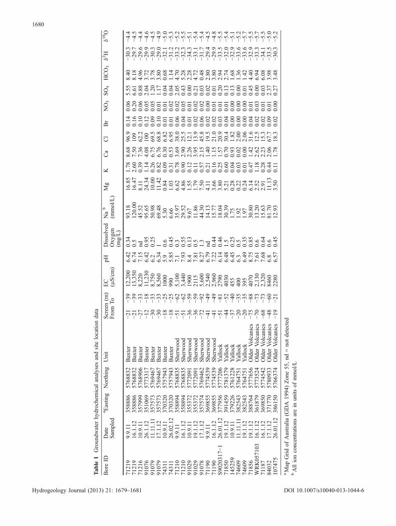
Tab
le1
Groundw
ater
hydrochemical
analyses
andsite
locatio
ndata
BoreID
Date
Sam
pled
a Eastin
gNorthing
Unit
Screen(m
)From
To
EC
(μS/cm)
pHDissolved
Oxy
gen
(mg/L)
Na
b
(mmol/L)
Mg
KCa
Cl
Br
NO3
SO4
HCO3
δ2H
δ18O
7121
99.9.11
3588
8657
6883
2Baxter
−21
−39
12,200
6.42
0.34
93.18
16.85
1.78
8.68
96.9
0.14
0.06
5.55
8.40
−30.3
−4.4
7121
916
.1.12
3588
8657
6883
2Baxter
−21
−39
13,350
6.74
0.5
120.00
16.47
2.60
7.50
109
0.16
0.20
6.61
8.18
−29.7
−4.5
7121
610
.9.11
3579
9957
6890
6Baxter
−27
−33
8,22
07.15
nd45
.52
8.11
0.39
7.36
62.2
0.10
0.06
0.88
4.96
−29.6
−4.4
9107
626
.1.12
3510
6957
7331
7Baxter
−12
−18
11,230
6.42
0.95
95.65
24.34
1.14
4.08
100
0.12
0.05
2.04
3.72
−29.9
−4.6
9107
911.11.11
3575
7357
6946
7Baxter
−30
−33
8,75
06.2
0.25
50.98
10.00
0.26
6.75
69.5
0.09
0.05
1.20
3.78
−30.3
−4.5
9107
917
.1.12
3575
7357
6946
7Baxter
−30
−33
8,56
06.34
169
.48
11.42
0.82
6.76
68.8
0.10
0.01
1.17
3.80
−29.0
−4.9
74311
10.9.11
3703
2057
5794
3Baxter
−18
−25
1000
5.9
0.6
5.30
0.84
0.09
0.30
6.82
0.01
0.01
0.04
0.68
−32.1
−5.0
74311
26.02.12
3703
2057
5794
3Baxter
−18
−25
990
5.85
0.45
6.66
1.03
0.31
0.53
6.95
0.01
0.02
0.04
1.14
−31.2
−5.3
7121
09.9.11
3588
9457
6883
5Sherw
ood
−51
−62
5,10
07.1
0.3
35.97
6.62
0.78
3.69
38.0
0.06
0.02
2.05
4.70
−33.2
−5.2
7121
016
.1.12
3588
9457
6883
5Sherw
ood
−51
−62
3,44
07.93
0.55
29.52
4.86
0.90
2.90
25.5
0.04
0.05
0.43
5.28
−32.3
−5.5
9102
910
.9.11
3553
7257
7209
1Sherw
ood
−36
−59
1900
8.4
0.13
9.67
1.55
0.12
2.26
12.1
0.01
0.01
0.00
2.28
−34.3
−5.1
9102
919
.1.12
3553
7257
7209
1Sherw
ood
−36
−59
2115
7.81
0.5
11.86
1.79
0.11
3.95
13.9
0.02
0.02
0.21
4.72
−33.1
−5.4
9107
817
.1.12
3575
7457
6946
2Sherw
ood
−72
−92
5,60
08.27
1.3
44.30
7.50
0.57
2.15
45.8
0.06
0.02
0.03
0.48
−31.7
−5.4
7119
09.9.11
3698
5557
7453
9Sherw
ood
−41
−49
2,54
06.79
nd14
.13
4.11
0.21
1.40
19.5
0.02
0.00
0.02
2.80
−29.4
−4.5
7119
016
.1.12
3698
5557
7453
9Sherw
ood
−41
−49
2,96
07.22
0.44
15.77
3.66
0.16
1.15
21.0
0.02
0.01
0.01
3.80
−29.9
−4.8
S90
2031
7−1
26.01.12
3779
5657
7720
6Yallock
−51
−81
2790
6.14
0.46
18.04
3.80
0.25
1.57
20.9
0.03
0.01
0.20
2.94
−33.5
−5.5
7185
019
.1.12
3914
5957
8137
9Yallock
−44
−52
4030
6.48
1.5
30.39
5.21
0.60
0.70
30.4
0.04
0.01
0.13
2.74
−32.0
−5.4
1452
5910
.9.11
3792
2657
6122
8Yallock
−37
−40
455
6.45
0.25
1.75
0.28
0.04
0.93
1.82
0.00
0.00
0.13
1.68
−32.9
−5.1
7460
911.11.11
3825
4357
6475
1Yallock
−20
−35
400
6.3
0.5
1.92
0.22
0.03
0.02
2.00
0.00
0.00
0.00
1.36
−33.6
−5.2
7460
919
.1.12
3825
4357
6475
1Yallock
−20
−35
395
6.49
0.35
1.97
0.24
0.01
0.00
2.06
0.00
0.00
0.01
1.42
−33.6
−5.7
7185
619
.1.12
3887
6457
7765
6Older
Volcanics
−75
−88
4070
8.75
0.85
30.80
6.14
0.47
1.42
31.6
0.04
0.01
0.45
4.40
−32.9
−5.5
WRK05
7103
16.1.12
3618
7957
7352
4Older
Volcanics
−70
−73
2,13
07.61
0.6
13.20
2.52
1.18
2.62
12.5
0.02
0.03
0.00
6.94
−33.3
−5.7
7118
716
.1.12
3698
5057
7454
2Older
Volcanics
−68
−73
2,32
07.68
0.64
15.63
2.91
0.28
2.23
15.3
0.02
0.01
0.03
6.08
−34.1
−5.5
8403
217
.1.12
3717
7057
8093
3Older
Volcanics
−48
−60
8460
6.8
0.6
81.70
11.13
0.44
2.06
67.7
0.09
0.01
2.37
3.98
−33.5
−5.0
1074
7526
.01.12
3861
5057
6637
4Older
Volcanics
−19
−21
2280
6.57
0.45
12.93
3.50
0.11
1.78
18.3
0.02
0.00
0.27
3.48
−30.3
−5.2
aMap
Gridof
Australia
(GDA
1994
)Zon
e55
,nd
=no
tdetected
bAllionconcentrations
arein
units
ofmmol/L
1680
Hydrogeology Journal (2013) 21: 1679–1681 DOI 10.1007/s10040-013-1044-6
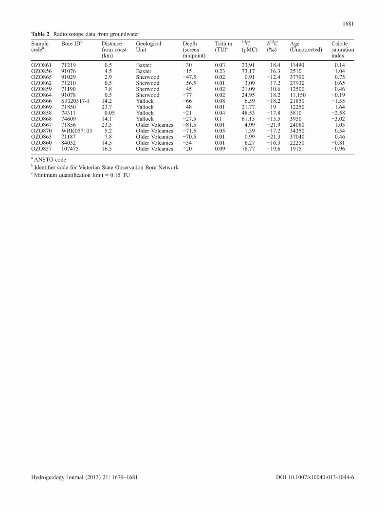
Table 2 Radioisotope data from groundwater
Samplecodea
Bore IDb Distancefrom coast(km)
GeologicalUnit
Depth(screenmidpoint)
Tritium(TU)c
14C(pMC)
δ13C(‰)
Age(Uncorrected)
Calcitesaturationindex
OZO861 71219 0.5 Baxter −30 0.03 23.91 −18.4 11490 −0.14OZO856 91076 4.5 Baxter −15 0.23 73.17 −16.3 2510 −1.04OZO865 91029 2.9 Sherwood −47.5 0.02 0.91 −12.4 37790 0.75OZO862 71210 0.5 Sherwood −56.5 0.01 3.09 −17.2 27930 −0.65OZO859 71190 7.8 Sherwood −45 0.02 21.09 −10.6 12500 −0.46OZO864 91078 0.5 Sherwood −77 0.02 24.95 18.2 11,150 −0.19OZO866 S9020317-1 14.2 Yallock −66 0.08 6.59 −18.2 21850 −1.55OZO869 71850 23.7 Yallock −48 0.01 21.77 −19 12250 −1.64OZO858 74311 0.05 Yallock −21 0.04 48.53 −17.8 5810 −2.58OZO868 74609 14.1 Yallock −27.5 0.1 61.15 −15.5 3950 −3.02OZO867 71856 23.5 Older Volcanics −81.5 0.01 4.99 −21.9 24080 1.03OZO870 WRK057103 5.2 Older Volcanics −71.5 0.05 1.39 −17.2 34350 0.54OZO863 71187 7.8 Older Volcanics −70.5 0.01 0.99 −21.3 37040 0.46OZO860 84032 14.5 Older Volcanics −54 0.01 6.27 −16.3 22250 −0.81OZO857 107475 16.5 Older Volcanics −20 0.09 78.77 −19.6 1915 −0.96aANSTO codeb Identifier code for Victorian State Observation Bore NetworkcMinimum quantification limit = 0.15 TU
1681
Hydrogeology Journal (2013) 21: 1679–1681 DOI 10.1007/s10040-013-1044-6