Embed Size (px)
Citation preview
Journal of the Meteorological Society of Japan, Vol. 87, No. 1, pp. 157--170, 2009. 157
DOI:10.2151/jmsj.87.157
Internal Structures of Migratory Cloud Systems with Diurnal Cycle
over Sumatera Island during CPEA-I Campaign
Namiko SAKURAI
Institute of Observational Research for Global Change, Japan Agency for Marine–Earth Science and Technology,
Yokosuka, Japan
Masayuki KAWASHIMA, Yasushi FUJIYOSHI
Institute of Low Temperature Science, Hokkaido University, Sapporo, Japan
Hiroyuki HASHIGUCHI
Research Institute for Sustainable Humanosphere, Kyoto University, Uji, Japan
Toyoshi SHIMOMAI
Faculty of Science and Engineering, Shimane University, Matsue, Japan
Shuichi MORI, HAMADA Jun-Ichi
Institute of Observational Research for Global Change, Japan Agency for Marine–Earth Science and Technology,
Yokosuka, Japan
Fumie MURATA
Faculty of Science, Kochi University, Kochi, Japan
Manabu D. YAMANAKA
Institute of Observational Research for Global Change, Japan Agency for Marine–Earth Science and Technology,
Yokosuka, Japan
Graduate School of Science, Kobe University, Kobe, Japan
Yudi Iman TAUHID, Tien SRIBIMAWATI
Agency for the Assessment and Application of Technology, Jakarta Pusat, Indonesia
and
Budi SUHARDI
Meteorological and Geophysical Agency, Jakarta, Indonesia
(Manuscript received 21 November 2005, in final form 14 November 2008)
Corresponding author: Namiko Sakurai, JapanAgency for Marine-Earth Science and Technology, 2-15 Natsushima-cho, Yokosuka 237-0061, Japan.E-mail: [email protected]( 2009, Meteorological Society of Japan
Abstract
There is a diurnal cycle of systematic cloud migration over Sumatera Island, i.e., cloud systems developing inthe mountainous area in the afternoon migrate westward and/or eastward for several hundreds of kilometers(about 500 km) from night to morning. The regional characteristics and internal structure of migratory cloud sys-tems with a diurnal cycle over Sumatera Island during CPEA-I were examined using data from an X-band Dop-pler radar (XDR), a VHF wind profiler (Equatorial Atmosphere Radar (EAR)), rawinsondes, and GeostationaryOperational Environmental Satellite (GOES9).
During CPEA-I, the cloud system had a horizontal scale of several hundred kilometers and migrated bothwestward and eastward over nearly all of Sumatera Island except for the southernmost part. The cloud systemmigrated only westward over southernmost Sumatera Island during CPEA-I.
From a case study on April 17 and 18, 2004, precipitation systems with horizontal scales of several tens ofkilometers were observed in a cloud system by XDR, and they migrated in a direction similar to that of the cloudsystem at a speed of about 3 m s�1, which roughly corresponded to the wind direction and speed in the lowertroposphere. Convective precipitation was observed mainly in the forward region of the precipitation systems,and stratiform precipitation was observed in the rearward region. The convective precipitation successively gen-erated new convective cells in front of old convective cells. These results suggest that the migratory mechanism ofthe precipitation systems is self-replication of convective cells and the advection of background wind in the lowertroposphere.
1. Introduction
A diurnal cycle of systematic migrations of cloudsystems exists over the entire Sumatera Island(about 1,500 km in length) in Indonesia (Mori et al.2004; Arakawa and Kitoh 2005; Sakurai et al.2005). The phenomenon is that cloud systems de-velop in a mountainous area in the afternoon andmigrate westward and/or eastward for several hun-dreds of kilometers (about 500 km) from night tomorning. From Geostationary Meteorological Sat-ellite (GMS) infrared-1 (IR1) data, Sakurai et al.(2005) found a di¤erence in the seasonal variationbetween westward and eastward migrations. West-ward migration was observed in almost all seasonsover all of Sumatera Island. On the other hand, theobserved area of the eastward migration oscillatednorthward and southward with an annual cycle.Eastward migration occurred in or near the Inter-tropical Convergence Zone (ITCZ), where a west-erly wind blew in the lower troposphere. This diur-nal cycle of cloud systems is associated with rainfall(Mori et al. 2004). Mori et al. (2004) showed the di-urnal cycle of rainfall peak migration over Suma-tera Island with precipitation radar (PR) data fromthe Tropical Rainfall Measuring Mission (TRMM)and rawinsonde data and suggested that the east-ward migration until the late evening might be dueto the background westerly wind in the lower tro-posphere, whereas the westward migration mightarise from the generation of new convection overthe windward side by self-replication and/or gravitywave mechanisms. The climatological characteris-
tics of rainfall migration with a diurnal cycle overSumatera and Borneo islands were simulated bya global climate model (GCM) with a horizontalgrid size of about 20 km (Arakawa and Kitoh2005). These results suggested that the rainfall mi-gration over land and coastal sea simulated by theGCM was associated with a gravity current.
These previous studies clarified the climatologicalcharacteristics of this diurnal cycle over SumateraIsland in each migratory direction. In these studies,however, the relationships between clouds and pre-cipitation were not thoroughly investigated becausethe TRMM PR data was discontinuous and GMSIR1 data was at hourly intervals. Cloud systemsthat migrated westward and eastward had a hori-zontal scale of several hundred kilometers andlasted for hours, which suggests that the cloud sys-tems consisted of smaller systems.
The period of the first campaign of CouplingProcess of Equatorial Atmosphere project (CPEA-I) was divided into two parts. In the latter half ofCPEA-I (April 10–May 9, 2004), intensive observa-tions were conducted over Sumatera and surround-ing islands for the purpose of observing the cou-pling between the lower and middle atmosphere,and we could get high resolution time and spacedata in the western part of Sumatera Island (Fukao2006). The objective of this paper is to describe,using the campaign data, the internal structures ofcloud systems that migrated both westward andeastward during the latter half of CPEA-I. This pa-per contributes to one of the objectives of the third
158 Journal of the Meteorological Society of Japan Vol. 87, No. 1
group in CPEA (understanding of the couplingprocess of convective clouds from the meso to thesynoptic scale) (Fukao 2006). Section 2 includesdata and observations. In Section 3, comprehensivecharacteristics of convective activities during thelatter half of CPEA-I are described. Section 4 con-tains a case study on the internal structures of cloudsystems that migrated both westward and eastwardon April 17 and 18, 2004. In Section 5, the charac-teristics obtained from a case study described inSection 4 are compared to climatological character-istics over Sumatera Island and similar phenomenaobserved in other areas. Section 6 is the conclusion.
2. Observation and data description
CPEA-I was performed over the Indonesia mari-time continent and Malay Peninsula for twomonths from March 10 to May 9, 2004. In thelatter half of CPEA-I, the lower atmosphere (tropo-sphere) was observed with several kinds of meteo-rological instruments (see Fukao (2006) for the de-tailed framework and contents of this observation).The period from April 10 to May 9 is referred to asCPEA-I in this paper.
2.1 Satellite data
In this study, the cloud top temperature obtainedwith a meteorological satellite (GeostationaryOperational Environmental Satellite (GOES9)) isanalyzed. The data of the black body temperatureðTBBÞ at 0:05� � 0:05� grid points by GOES9 IR1for one month (April 10–May 9) is used for theanalysis of the cloud top temperature. The tempo-ral resolution is one hour. In order to discriminatedeep convection and omit ground temperature, athreshold value of TBB (Tc ¼ 230 K) is used in thisstudy following previous studies (e.g., Hendon andWoodberry 1993; Satomura 2000; Ohsawa et al.2001; Sakurai et al. 2005). The Tc value of 230 Kcorresponds to air temperature near an altitude of11 km. An occurrence frequency a of deep cloudsystems ðTBB aTcÞ at each pixel and time is calcu-lated as follows (cf. Sakurai et al. 2005):
a1ðNumber of TBB < Tc at each pixel and hour for analysis periodÞðNumber of valid data at each pixel and hour for analysis periodÞ
� 100; ð1Þ
which reveals how frequently convective cloudspenetrate above 11 km at each pixel and hour forthe analysis period. The analysis period is fromApril 10 to May 9, 2004, in this study. a is not cal-
culated when the number of missing data exceeds 4for the analysis period.
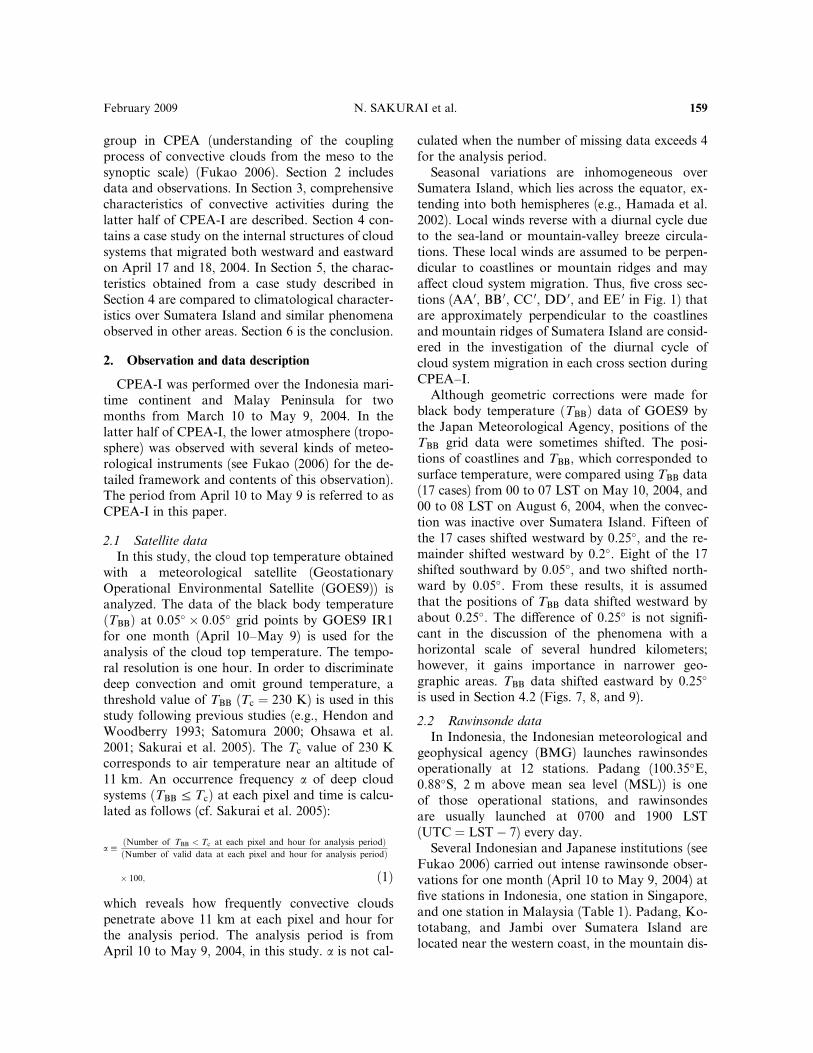
Seasonal variations are inhomogeneous overSumatera Island, which lies across the equator, ex-tending into both hemispheres (e.g., Hamada et al.2002). Local winds reverse with a diurnal cycle dueto the sea-land or mountain-valley breeze circula-tions. These local winds are assumed to be perpen-dicular to coastlines or mountain ridges and maya¤ect cloud system migration. Thus, five cross sec-tions (AA0, BB 0, CC 0, DD 0, and EE 0 in Fig. 1) thatare approximately perpendicular to the coastlinesand mountain ridges of Sumatera Island are consid-ered in the investigation of the diurnal cycle ofcloud system migration in each cross section duringCPEA–I.
Although geometric corrections were made forblack body temperature ðTBBÞ data of GOES9 bythe Japan Meteorological Agency, positions of theTBB grid data were sometimes shifted. The posi-tions of coastlines and TBB, which corresponded tosurface temperature, were compared using TBB data(17 cases) from 00 to 07 LST on May 10, 2004, and00 to 08 LST on August 6, 2004, when the convec-tion was inactive over Sumatera Island. Fifteen ofthe 17 cases shifted westward by 0.25�, and the re-mainder shifted westward by 0.2�. Eight of the 17shifted southward by 0.05�, and two shifted north-ward by 0.05�. From these results, it is assumedthat the positions of TBB data shifted westward byabout 0.25�. The di¤erence of 0.25� is not signifi-cant in the discussion of the phenomena with ahorizontal scale of several hundred kilometers;however, it gains importance in narrower geo-graphic areas. TBB data shifted eastward by 0.25�
is used in Section 4.2 (Figs. 7, 8, and 9).
2.2 Rawinsonde data
In Indonesia, the Indonesian meteorological andgeophysical agency (BMG) launches rawinsondesoperationally at 12 stations. Padang (100.35�E,0.88�S, 2 m above mean sea level (MSL)) is oneof those operational stations, and rawinsondesare usually launched at 0700 and 1900 LST(UTC ¼ LST� 7) every day.
Several Indonesian and Japanese institutions (seeFukao 2006) carried out intense rawinsonde obser-vations for one month (April 10 to May 9, 2004) atfive stations in Indonesia, one station in Singapore,and one station in Malaysia (Table 1). Padang, Ko-totabang, and Jambi over Sumatera Island arelocated near the western coast, in the mountain dis-
February 2009 N. SAKURAI et al. 159
tricts, and in the plains around 100 km inland fromthe eastern coast, respectively. The first two stationsare located roughly almost along the CC 0 cross sec-tion in Fig. 1, and the third station is near the DD 0
cross section.In this study we analyzed the rawinsonde data
observed at Kototabang in CPEA-I. The receiverand transmitters of a GPS-rawinsonde system (Vai-sala RS92SGP) with meteorological balloons (TO-
TEX TA-1000 type for the daytime, and TX-1000type for the nighttime) were employed at Kotota-bang. The rawinsonde system can obtain thevertical profiles of temperature, relative humidity,pressure, and zonal and meridional winds with avertical resolution of 100 m. The analysis periodcorresponds to one of two rainy seasons, fromMarch to May and September to November in thecentral part of Sumatera (Hamada 2003), which ap-pear to be due to the annual variation (north–southshift around the equator) of ITCZ (Murakami andMatsumoto 1994; Okamoto et al. 2003). Rawin-sondes were basically launched 4 times daily atapproximately 0030, 0630, 1230, and 1830 LSTduring CPEA-I basically, whereas rawinsonde ob-servation was conducted 8 times daily at 0030,0330, 0630, 0930, 1230, 1530, 1830, and 2130 LSTin the period April 18–22 and 29–30, 2004.
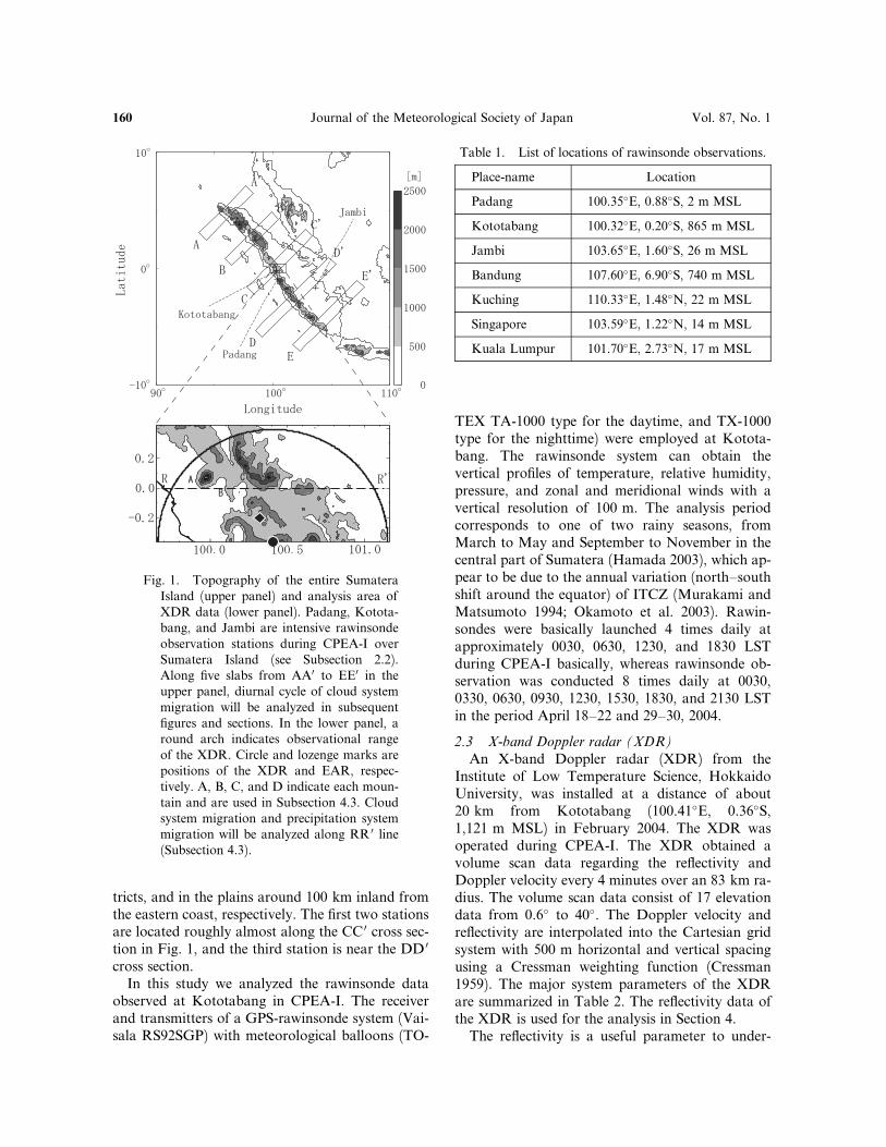
2.3 X-band Doppler radar (XDR)
An X-band Doppler radar (XDR) from theInstitute of Low Temperature Science, HokkaidoUniversity, was installed at a distance of about20 km from Kototabang (100.41�E, 0.36�S,1,121 m MSL) in February 2004. The XDR wasoperated during CPEA-I. The XDR obtained avolume scan data regarding the reflectivity andDoppler velocity every 4 minutes over an 83 km ra-dius. The volume scan data consist of 17 elevationdata from 0.6� to 40�. The Doppler velocity andreflectivity are interpolated into the Cartesian gridsystem with 500 m horizontal and vertical spacingusing a Cressman weighting function (Cressman1959). The major system parameters of the XDRare summarized in Table 2. The reflectivity data ofthe XDR is used for the analysis in Section 4.
The reflectivity is a useful parameter to under-
Fig. 1. Topography of the entire SumateraIsland (upper panel) and analysis area ofXDR data (lower panel). Padang, Kotota-bang, and Jambi are intensive rawinsondeobservation stations during CPEA-I overSumatera Island (see Subsection 2.2).Along five slabs from AA0 to EE0 in theupper panel, diurnal cycle of cloud systemmigration will be analyzed in subsequentfigures and sections. In the lower panel, around arch indicates observational rangeof the XDR. Circle and lozenge marks arepositions of the XDR and EAR, respec-tively. A, B, C, and D indicate each moun-tain and are used in Subsection 4.3. Cloudsystem migration and precipitation systemmigration will be analyzed along RR 0 line(Subsection 4.3).
Table 1. List of locations of rawinsonde observations.
Place-name Location
Padang 100.35�E, 0.88�S, 2 m MSL
Kototabang 100.32�E, 0.20�S, 865 m MSL
Jambi 103.65�E, 1.60�S, 26 m MSL
Bandung 107.60�E, 6.90�S, 740 m MSL
Kuching 110.33�E, 1.48�N, 22 m MSL
Singapore 103.59�E, 1.22�N, 14 m MSL
Kuala Lumpur 101.70�E, 2.73�N, 17 m MSL
160 Journal of the Meteorological Society of Japan Vol. 87, No. 1
stand precipitation types and structure. The precip-itation types, i.e., convective and stratiform, areclassified on the basis of the intensity and sharpnessof the peaks of reflectivity using a method devel-oped by Steiner et al. (1995).
2.4 Equatorial atmosphere radar (EAR)
A VHF (47.0 MHz) Doppler radar with anactive phased-array antenna system called EARhas been operated at Kototabang since June 2001(Fukao et al. 2003). It detects three-dimensional at-mospheric motions, such as rain drops or clear airturbulence, in the atmosphere from 2 to 20 km.The EAR has a time resolution of approximately90 s and a vertical resolution of approximately150 m. The time resolution of the EAR is, thus,much finer than the time resolution of rawinsondes,even during intense observational periods, and itprovides detailed time features in the diurnal cycle.In this paper, EAR data on April 17 and 18, 2004averaged every hour are used for the analysis toexamine the detailed three-dimensional airflow asa background wind around Kototabang. Hourlywind data is not calculated if the EAR data is notobtained for more than 30 minutes in an hour.
2.5 Objective analysis data
Horizontal wind of the NCEP/NCAR reanalysisdataset provided by the US National Weather Ser-vice is used. The spatial resolution and analysis pe-riod are 2:5� � 2:5� grid points and two days (April17 and 18, 2004), respectively. The temporal resolu-tion is 6 hours (00, 06, 12, and 18 UTC). The verti-cal resolution of horizontal wind is 17 standardpressure levels from 1,000 to 10 hPa.
3. General characteristics of the diurnal cycle of
cloud systems during CPEA-I
3.1 Daily convective activity on the equator
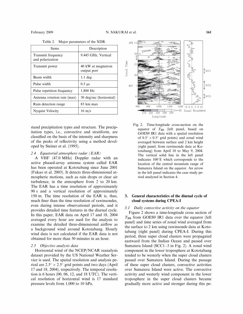
Figure 2 shows a time-longitude cross section ofTBB from GOES9 IR1 data over the equator (leftpanel) and time series of zonal wind averaged fromthe surface to 2 km using rawinsonde data at Koto-tabang (right panel) during CPEA-I. During thisperiod, three super cloud clusters were propagatedeastward from the Indian Ocean and passed overSumatera Island (SCC1–3 in Fig. 2). A zonal windcomponent in the lower troposphere at Kototabangtended to be westerly when the super cloud clusterspassed over Sumatera Island. During the passageof these super cloud clusters, convective activitiesover Sumatera Island were active. The convectiveactivity and westerly wind component in the lowertroposphere in the super cloud clusters becamegradually more active and stronger during this pe-
Fig. 2. Time-longitude cross-section on theequator of TBB (left panel, based onGOES9 IR1 data with a spatial resolutionof 0:5� � 0:5� grid points) and zonal windaveraged between surface and 2 km height(right panel, from rawinsonde data at Ko-totabang) from April 10 to May 9, 2004.The vertical solid line in the left panelindicates 100�E which corresponds to thelocation of the central mountain range ofSumatera Island on the equator. An arrowin the left panel indicates the case study pe-riod analyzed in Section 4.
Table 2. Major parameters of the XDR.
Items Description
Transmit frequencyand polarization
9.445 GHz, Vertical
Transmit power 40 kW at magnetronoutput port
Beam width 1.1 deg
Pulse width 0.5 ms
Pulse repetition frequency 1,800 Hz
Antenna rotation rate (max) 30 deg/sec (horizontal)
Rain detection range 83 km max
Nyquist Velocity 16 m/s
February 2009 N. SAKURAI et al. 161
riod: SCC1 and SCC2 were obscured after the pas-sage over Sumatera Island, whereas SCC3 clearlypassed over the Indonesian maritime continent.After the passage of SCC3, convection became in-active over Sumatera Island. On April 11, 13–15,and 18, daily convective activity was active andwas not a¤ected by any large-scale disturbances,such as a super cloud cluster, and a weak westerlywind blew in the lower troposphere over SumateraIsland (around 100�E). A case study of cloud sys-tems on April 17 and 18 is shown in Section 4.
3.2 Diurnal cycle of cloud system migration
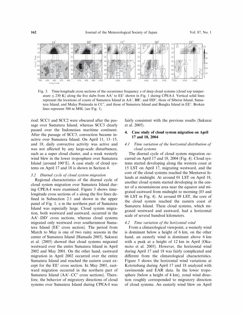
Regional characteristics of the diurnal cycle ofcloud system migration over Sumatera Island dur-ing CPEA-I were examined. Figure 3 shows time-longitude cross sections of a along the five lines de-fined in Subsection 2.1 and shown in the upperpanel of Fig. 1. a in the northern part of SumateraIsland was especially large. Cloud system migra-tion, both westward and eastward, occurred in theAA0–DD 0 cross sections, whereas cloud systemsmigrated only westward over southernmost Suma-tera Island (EE 0 cross section). The period fromMarch to May is one of two rainy seasons in thecenter of Sumatera Island (Hamada 2003). Sakuraiet al. (2005) showed that cloud systems migratedwestward over the entire Sumatera Island in April2002 and May 2001. On the other hand, eastwardmigration in April 2002 occurred over the entireSumatera Island and reached the eastern coast ex-cept for the EE 0 cross section. In May 2001, east-ward migration occurred in the northern part ofSumatera Island (AA0–CC 0 cross sections). There-fore, the behavior of migratory directions of cloudsystems over Sumatera Island during CPEA-I was
fairly consistent with the previous results (Sakuraiet al. 2005).
4. Case study of cloud system migration on April
17 and 18, 2004
4.1 Time variation of the horizontal distribution of
cloud systems
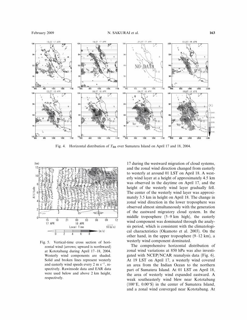
The diurnal cycle of cloud system migration oc-curred on April 17 and 18, 2004 (Fig. 4). Cloud sys-tems started developing along the western coast at15 LST on April 17, migrating westward, and thecore of the cloud systems reached the Mentawai Is-lands at midnight. At around 01 LST on April 18,another cloud system started developing in the cen-ter of a mountainous area near the equator and mi-grated eastward from midnight to morning (03 and06 LST in Fig. 4). At around 09 LST, the core ofthe cloud system reached the eastern coast ofSumatera Island. These cloud systems, which mi-grated westward and eastward, had a horizontalscale of several hundred kilometers.
4.2 Time variation of the horizontal wind
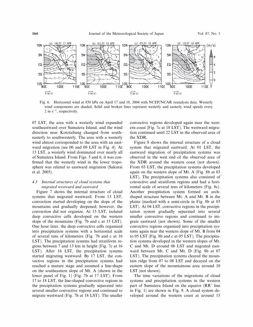
From a climatological viewpoint, a westerly windis dominant below a height of 6 km, on the otherhand, an easterly wind is dominant above 6 kmwith a peak at a height of 12 km in April (Oka-moto et al. 2003). However, the horizontal windduring April 17 and 18 was fairly complicated anddi¤erent from the climatological characteristics.Figure 5 shows the horizontal wind variations atKototabang during April 17 and 18 analyzed withrawinsonde and EAR data. In the lower tropo-sphere (below a height of 4 km), zonal wind direc-tion roughly corresponded to migratory directionof cloud systems. An easterly wind blew on April
Fig. 3. Time-longitude cross sections of the occurrence frequency a of deep cloud systems (cloud top temper-aturea 230 K) along the five slabs from AA 0 to EE 0 shown in Fig. 1 during CPEA-I. Vertical solid linesrepresent the locations of coasts of Sumatera Island in AA 0, BB 0, and DD 0, those of Siberut Island, Suma-tera Island, and Malay Peninsula in CC 0, and those of Sumatera Island and Bangka Island in EE 0. Brokenlines represent 500 m MSL (see Fig. 1).
162 Journal of the Meteorological Society of Japan Vol. 87, No. 1
17 during the westward migration of cloud systems,and the zonal wind direction changed from easterlyto westerly at around 01 LST on April 18. A west-erly wind layer at a height of approximately 4.5 kmwas observed in the daytime on April 17, and theheight of the westerly wind layer gradually fell.The center of the westerly wind layer was approxi-mately 3.5 km in height on April 18. The change inzonal wind direction in the lower troposphere wasobserved almost simultaneously with the generationof the eastward migratory cloud system. In themiddle troposphere (5–9 km high), the easterlywind component was dominated through the analy-sis period, which is consistent with the climatologi-cal characteristics (Okamoto et al. 2003). On theother hand, in the upper troposphere (9–12 km), awesterly wind component dominated.
The comprehensive horizontal distribution ofzonal wind variations at 850 hPa was also investi-gated with NCEP/NCAR reanalysis data (Fig. 6).At 19 LST on April 17, a westerly wind coveredan area from the Indian Ocean to the northernpart of Sumatera Island. At 01 LST on April 18,the area of westerly wind expanded eastward. Aweak southeasterly wind blew near Kototabang(100�E, 0.00�S) in the center of Sumatera Island,and a zonal wind converged near Kototabang. At
Fig. 4. Horizontal distribution of TBB over Sumatera Island on April 17 and 18, 2004.
Fig. 5. Vertical-time cross section of hori-zontal wind (arrows; upward is northward)at Kototabang during April 17–18, 2004.Westerly wind components are shaded.Solid and broken lines represent westerlyand easterly wind speeds every 2 m s�1, re-spectively. Rawinsode data and EAR datawere used below and above 2 km height,respectively.
February 2009 N. SAKURAI et al. 163
07 LST, the area with a westerly wind expandedsoutheastward over Sumatera Island, and the winddirection near Kototabang changed from south-easterly to southwesterly. The area with a westerlywind almost corresponded to the area with an east-ward migration (see 06 and 09 LST in Fig. 4). At13 LST, a westerly wind dominated over nearly allof Sumatera Island. From Figs. 5 and 6, it was con-firmed that the westerly wind in the lower tropo-sphere was related to eastward migration (Sakuraiet al. 2005).
4.3 Internal structures of cloud systems that
migrated westward and eastward
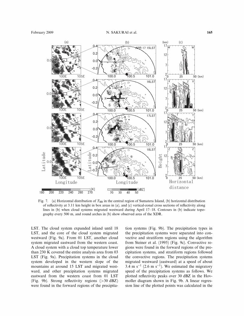
Figure 7 shows the internal structure of cloudsystems that migrated westward. From 13 LST,convection started developing on the slope of themountains and gradually deepened; however, theconvection did not organize. At 15 LST, isolateddeep convective cells developed on the westernslope of the mountains (Fig. 7b and c at 15 LST).One hour later, the deep convective cells organizedinto precipitation systems with a horizontal scaleof several tens of kilometers (Fig. 7b and c at 16LST). The precipitation systems had stratiform re-gions between 7 and 13 km in height (Fig. 7c at 16LST). After 16 LST, the precipitation systemsstarted migrating westward. By 17 LST, the con-vective regions in the precipitation systems hadreached a mature stage and assumed a line-shapeon the southeastern slope of Mt. A (shown in thelower panel of Fig. 1) (Fig. 7b at 17 LST). From17 to 18 LST, the line-shaped convective regions inthe precipitation systems gradually separated intoseveral smaller convective regions and continued tomigrate westward (Fig. 7b at 18 LST). The smaller
convective regions developed again near the west-ern coast (Fig. 7c at 18 LST). The westward migra-tion continued until 22 LST in the observed area ofthe XDR.
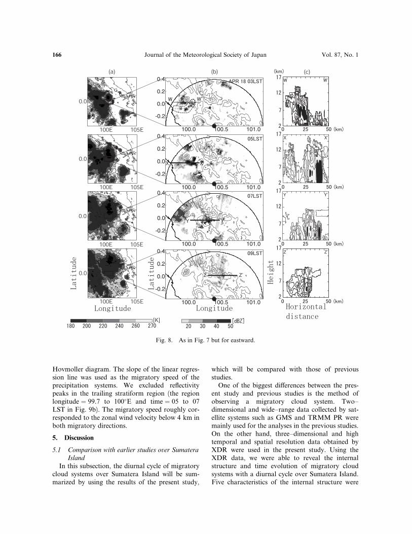
Figure 8 shows the internal structure of a cloudsystem that migrated eastward. At 01 LST, theeastward migration of precipitation systems wasobserved in the west end of the observed area ofthe XDR around the western coast (not shown).From 03 LST, the precipitation systems developedagain on the western slope of Mt. A (Fig. 8b at 03LST). The precipitation systems also consisted ofconvective and stratiform regions and had a hori-zontal scale of several tens of kilometers (Fig. 8c).Another precipitation system formed an arch-shaped structure between Mt. A and Mt. B in theplains (marked with a semi-circle in Fig. 8b at 03LST). At 04 LST, convective regions in the precipi-tation system gradually separated into severalsmaller convective regions and continued to mi-grate eastward (not shown). Some of the smallerconvective regions organized into precipitation sys-tems again near the western slope of Mt. B from 04to 05 LST (Fig. 8b and c at 05 LST). The precipita-tion systems developed in the western slopes of Mt.C and Mt. D around 06 LST and migrated east-ward between Mt. C and Mt. D (Fig. 8b at 07LST). The precipitation systems cleared the moun-tain ridge from 07 to 08 LST and decayed on theeastern slope of the mountainous area around 10LST (not shown).
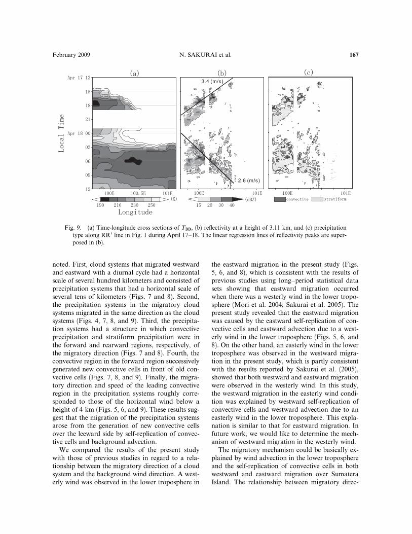
The time variations of the migrations of cloudsystems and precipitation systems in the westernpart of Sumatera Island on the equator (RR 0 linein Fig. 1) are shown in Fig. 9. A cloud system de-veloped around the western coast at around 15
Fig. 6. Horizontal wind at 850 hPa on April 17 and 18, 2004 with NCEP/NCAR reanalysis data. Westerlywind components are shaded. Solid and broken lines represent westerly and easterly wind speeds every2 m s�1, respectively.
164 Journal of the Meteorological Society of Japan Vol. 87, No. 1
LST. The cloud system expanded inland until 18LST, and the core of the cloud system migratedwestward (Fig. 9a). From 01 LST, another cloudsystem migrated eastward from the western coast.A cloud system with a cloud top temperature lowerthan 230 K covered the entire analysis area from 03LST (Fig. 9a). Precipitation systems in the cloudsystem developed in the western slope of themountains at around 15 LST and migrated west-ward, and other precipitation systems migratedeastward from the western coast from 01 LST(Fig. 9b). Strong reflectivity regions (>30 dBZ)were found in the forward regions of the precipita-
tion systems (Fig. 9b). The precipitation types inthe precipitation systems were separated into con-vective and stratiform regions using the algorithmfrom Steiner et al. (1995) (Fig. 9c). Convective re-gions were found in the forward regions of the pre-cipitation systems, and stratiform regions followedthe convective regions. The precipitation systemsmigrated westward (eastward) at a speed of about3.4 m s�1 (2.6 m s�1). We estimated the migratoryspeed of the precipitation systems as follows. Weplotted reflectivity peaks over 30 dBZ in the Hov-moller diagram shown in Fig. 9b. A linear regres-sion line of the plotted points was calculated in the
Fig. 7. (a) Horizontal distribution of TBB in the central region of Sumatera Island, (b) horizontal distributionof reflectivity at 3.11 km height in box areas in (a), and (c) vertical-zonal cross sections of reflectivity alonglines in (b) when cloud systems migrated westward during April 17–18. Contours in (b) indicate topo-graphy every 500 m, and round arches in (b) show observed area of the XDR.
February 2009 N. SAKURAI et al. 165
Hovmoller diagram. The slope of the linear regres-sion line was used as the migratory speed of theprecipitation systems. We excluded reflectivitypeaks in the trailing stratiform region (the regionlongitude ¼ 99.7 to 100�E and time ¼ 05 to 07LST in Fig. 9b). The migratory speed roughly cor-responded to the zonal wind velocity below 4 km inboth migratory directions.
5. Discussion
5.1 Comparison with earlier studies over Sumatera
Island
In this subsection, the diurnal cycle of migratorycloud systems over Sumatera Island will be sum-marized by using the results of the present study,
which will be compared with those of previousstudies.
One of the biggest di¤erences between the pres-ent study and previous studies is the method ofobserving a migratory cloud system. Two–dimensional and wide–range data collected by sat-ellite systems such as GMS and TRMM PR weremainly used for the analyses in the previous studies.On the other hand, three–dimensional and hightemporal and spatial resolution data obtained byXDR were used in the present study. Using theXDR data, we were able to reveal the internalstructure and time evolution of migratory cloudsystems with a diurnal cycle over Sumatera Island.Five characteristics of the internal structure were
Fig. 8. As in Fig. 7 but for eastward.
166 Journal of the Meteorological Society of Japan Vol. 87, No. 1
noted. First, cloud systems that migrated westwardand eastward with a diurnal cycle had a horizontalscale of several hundred kilometers and consisted ofprecipitation systems that had a horizontal scale ofseveral tens of kilometers (Figs. 7 and 8). Second,the precipitation systems in the migratory cloudsystems migrated in the same direction as the cloudsystems (Figs. 4, 7, 8, and 9). Third, the precipita-tion systems had a structure in which convectiveprecipitation and stratiform precipitation were inthe forward and rearward regions, respectively, ofthe migratory direction (Figs. 7 and 8). Fourth, theconvective region in the forward region successivelygenerated new convective cells in front of old con-vective cells (Figs. 7, 8, and 9). Finally, the migra-tory direction and speed of the leading convectiveregion in the precipitation systems roughly corre-sponded to those of the horizontal wind below aheight of 4 km (Figs. 5, 6, and 9). These results sug-gest that the migration of the precipitation systemsarose from the generation of new convective cellsover the leeward side by self-replication of convec-tive cells and background advection.
We compared the results of the present studywith those of previous studies in regard to a rela-tionship between the migratory direction of a cloudsystem and the background wind direction. A west-erly wind was observed in the lower troposphere in
the eastward migration in the present study (Figs.5, 6, and 8), which is consistent with the results ofprevious studies using long–period statistical datasets showing that eastward migration occurredwhen there was a westerly wind in the lower tropo-sphere (Mori et al. 2004; Sakurai et al. 2005). Thepresent study revealed that the eastward migrationwas caused by the eastward self-replication of con-vective cells and eastward advection due to a west-erly wind in the lower troposphere (Figs. 5, 6, and8). On the other hand, an easterly wind in the lowertroposphere was observed in the westward migra-tion in the present study, which is partly consistentwith the results reported by Sakurai et al. (2005),showed that both westward and eastward migrationwere observed in the westerly wind. In this study,the westward migration in the easterly wind condi-tion was explained by westward self-replication ofconvective cells and westward advection due to aneasterly wind in the lower troposphere. This expla-nation is similar to that for eastward migration. Infuture work, we would like to determine the mech-anism of westward migration in the westerly wind.
The migratory mechanism could be basically ex-plained by wind advection in the lower troposphereand the self-replication of convective cells in bothwestward and eastward migration over SumateraIsland. The relationship between migratory direc-
Fig. 9. (a) Time-longitude cross sections of TBB, (b) reflectivity at a height of 3.11 km, and (c) precipitationtype along RR 0 line in Fig. 1 during April 17–18. The linear regression lines of reflectivity peaks are super-posed in (b).
February 2009 N. SAKURAI et al. 167
tion and wind direction obtained in the presentstudy corresponds well to statistical relationshipsobtained in past studies.
5.2 Comparison with earlier studies in other
regions
We discuss the applicability of the relationshipbetween migratory direction and wind directionover Sumatera Island, covered in the previous sub-section, to other tropical regions.
According to Yang and Slingo (2001), a diurnalcycle of cloud system migration for several hundredkilometers has been observed in many regions: Ka-limantan Island (Houze et al. 1981; Johnson andKriete 1982; Ichikawa and Yasunari 2006) andNew Guinea Island (Liberti et al. 2001) over themaritime continent, the vicinity of western Colom-bia (Mapes et al. 2003a, b; Warner et al. 2003), theBay of Bengal (Zuidema et al. 2003), northeasternBangladesh (Kataoka and Satomura 2005), andthe Indochina Peninsula (Satomura 2000; Okumuraet al. 2003). We selected studies that investigatedthe relationship between migratory direction andwind direction using long term data (Ichikawa andYasunari 2006; Okumura et al. 2003).
The relationship between the migratory directionof precipitation systems and wind direction in thelower troposphere over Sumatera Island can becompared to that found over Kalimantan Island.Ichikawa and Yasunari (2006) reported that rain-fall regions propagated from the mountainous areato the leeward side over Kalimantan Island be-tween midnight and morning (e.g., westward mi-gration in the easterly regime and eastward migra-tion in the westerly regime). These migratoryspeeds, both westward and eastward, roughly cor-responded to the 700-hPa wind speed. On the otherhand, nocturnal rainfall generated around thenorthwest coast of Kalimantan Island moved o¤-shore in a westward direction under the conditionsof both westerly and easterly winds in the lower tro-posphere (Ichikawa and Yasunari 2006). The diur-nal cycle of westward migration originating in themountainous area and around the northwesterncoast over Kalimantan Island seems similar to thatof westward migration over Sumatera Island interms of the relationship between migratory direc-tion and the background wind direction in the low-er troposphere. Similarly, the diurnal cycle of east-ward migration generated in the mountainous areaover Kalimantan Island seems similar to that ofeastward migration over Sumatera Island in terms
of the relationship between migratory directionand background wind direction in the lower tropo-sphere. The migratory mechanism suggested in theprevious subsection could be applied to the similardiurnal cycle of the leeward migration observedover Kalimantan Island.
On the Indochina Peninsula, the diurnal cycle ofmigratory precipitation systems has a relationshipbetween migratory direction and background winddirection similar to that over Sumatera Island. Theprecipitation systems originating in the mountain-ous area in the evening migrated leeward in south-westerly and northeasterly monsoon seasons. In thesouthwesterly monsoons, the precipitation systemsmigrated inland (northeastward); on the otherhand, in the northeasterly monsoons, the precipita-tion systems migrated to the coast and the sea(southwestward). In addition, in the southwesterlymonsoons, the precipitation systems migrated notonly from the mountainous area to the inland butalso from the coast to the sea (Fig. 4a in Okumuraet al. (2003)). It seems that the diurnal cycle ofsouthwestward (northeastward) migration over theIndochina Peninsula is similar to that of westward(eastward) migration over Sumatera Island in termsof the relationship between migratory direction andbackground wind direction in the lower tropo-sphere. The precipitation systems were maintainedby the continuous generation of new convectivecells at the leading edge of the cold pool over Indo-china Peninsula (Satomura 2000). The migratoryspeed of the precipitation systems over IndochinaPeninsula nearly corresponded to the wind speedin the lower troposphere when the precipitation sys-tems migrated to the leeward sides (Okumura et al.2003; Satomura 2000). The migratory mechanismsuggested in the previous subsection could be ap-plied to the similar diurnal cycle observed over theIndochina Peninsula.
To summarize the applicability of the relation-ship between migratory direction and wind direc-tion in the lower troposphere to other tropical re-gions, the relationship over Sumatera Island couldbe applied to similar migratory systems in a diurnalcycle in other tropical regions such as KalimantanIsland and Indochina Peninsula. The eastward(westward) migration of precipitation systems fromthe mountainous area occurs in the westerly (east-erly) wind in the lower troposphere. The westwardmigration originating around the coast occurs inboth westerly and easterly winds in the lower tropo-sphere.
168 Journal of the Meteorological Society of Japan Vol. 87, No. 1
6. Conclusion
The regional characteristics and the internalstructure of migratory cloud systems with a diurnalcycle over Sumatera Island during CPEA-I were in-vestigated using CPEA-I data. During CPEA-I,cloud system migration westward and eastwardoccurred in AA0–DD 0 cross sections. Only west-ward migration was observed in the southernmostSumatera Island (EE 0) during CPEA-I. These re-gional characteristics were fairly consistent withthe seasonal characteristics shown in a previousstudy.
From a case study on April 17 and 18, 2004,cloud systems that migrated westward and east-ward were found to include several precipitationsystems with a horizontal scale of several tens ofkilometers. In addition, the precipitation systemshad convective precipitation in the forward regionand stratiform precipitation in the rearward region,and the convective precipitation successively gener-ated new convective cells in front of old convectivecells. The migratory direction and speed (about3 m s�1) of the convective precipitation roughlycorresponded to those of the horizontal wind inthe lower troposphere. These results suggest thatthe migratory mechanism of the precipitation sys-tems is the self-replication of convective cells andthe background wind advection in the lower tropo-sphere.
Acknowledgments
We heartily thank the colleagues of BPPT,BMG, and LAPAN on the Indonesian side and ofKyoto University, Hokkaido University, ShimaneUniversity, and JAMSTEC on the Japanese sidefor their strong collaborations in observations. TheCPEA project was supported by a Grant-in-Aid forScientific Research on Priority Area-764 of theMinistry of Education, Culture, Sports, Science,and Technology (MEXT) of Japan. We would liketo thank Professors T. Tsuda and T. Kozu for theircoordination with rawinsonde observations. TheEAR belongs to RISH of Kyoto University, Japan,and is operated by RISH and LAPAN, Indonesia,based upon an agreement between RISH andLAPAN signed on September 8, 2000. We wouldlike to express our gratitude to Dr. T. Ohsawa formany useful suggestions for the present work.Thanks are also extended to the constructive com-ments of the Editor (Dr. Y. Kodama) and twoanonymous reviewers, who greatly improved the
content of this manuscript. The authors would liketo thank Dr. T. Kikuchi of Kochi University forproviding GOES9 IR1 data. Figures were drawnusing GrADS, free software developed by Brian E.Doty, Center for Ocean-Land-Atmosphere Interac-tion, Department of Meteorology, University ofMaryland. Generic Mapping Tools (GMT) werealso used for drawing the figures.
References
Arakawa, O., and A. Kitoh, 2005: Rainfall diurnal varia-tion over the Indonesian maritime continent simu-lated by 20 km-mesh GCM. SOLA, 1, 109–112.
Cressman, G. P., 1959: An operational objective analysissystem. Mon. Wea. Rev., 87, 367–374.
Fukao, S., H. Hashiguchi, M. Yamamoto, T. Tsuda, T.Nakamura, M. K. Yamamoto, T. Sato, M. Hagio,and Y. Yabugaki, 2003: Equatorial atmosphereradar (EAR): System description and firstresults. Radio Sci., 38, 3, 1053, doi:10.1029/2002RS002767.
Fukao, S., 2006: Coupling Processes in the EquatorialAtmosphere (CPEA): A Project Overview. J. Me-
teor. Soc. Japan, 84A, 1–18.Hamada, J. -I., M. D. Yamanaka, J. Matsumoto, S.
Fukao, P. A. Winarso, and T. Sribimawati, 2002:Spatial and temporal variations of the rainy seasonover Indonesia and their link to ENSO. J. Meteor.
Soc. Japan, 80, 285–310.Hamada, J. -I., 2003: A climatological study on rainfall
variations over the Indonesian maritime continent,Doctoral thesis, Graduate School of Science,Kyoto University, 189 pp.
Hendon, H. H., and K. Woodberry, 1993: The diurnalcycle of tropical convection. J. Geophys. Res., 98,16623–16637.
Houze, R. A., Jr., S. G. Geotis, F. D. Marks, Jr., andA. K. West, 1981: Winter monsoon convection inthe vicinity of north Borneo. Part I: Structure andtime variation of the clouds and precipitation.Mon. Wea. Rev., 109, 1595–1614.
Ichikawa, H., and T. Yasunari, 2006: Time-space charac-teristics of diurnal rainfall over Borneo and sur-rounding oceans as observed by TRMM-PR. J.
Climate, 19, 1238–1260.Johnson, R. H., and D. C. Kriete, 1982: Thermodynamic
and circulation characteristics of winter monsoontropical mesoscale convection. Mon. Wea. Rev.,110, 1898–1911.
Kataoka, A., and T. Satomura, 2005: Numerical simula-tion on the diurnal variation of precipitation overnortheastern Bangladesh: A case study of an activeperiod 14–21 June 1995. SOLA, 1, 205–208.
Liberti, G. L., F. Cheruy, and M. Desbois, 2001: Lande¤ect on the diurnal cycle of clouds over the
February 2009 N. SAKURAI et al. 169

TOGA COARE area, as observed from GMS IRdata. Mon. Wea. Rev., 129, 1500–1517.
Mapes, B. E., T. T. Warner, M. Xu and A. J. Negri,2003a: Diurnal patterns of rainfall in northwesternSouth America. Part I: Observations and context.Mon. Wea. Rev., 131, 799–812.
Mapes, B. E., T. T. Warner, and M. Xu, 2003b: Diurnalpatterns of rainfall in northwestern South America.Part III: Diurnal gravity waves and nocturnal con-vection o¤shore. Mon. Wea. Rev., 131, 830–844.
Mori, S., J. -I. Hamada, Y. I. Tauhid, M. D. Yamanaka,N. Okamoto, F. Murata, N. Sakurai, H. Hashigu-chi, and T. Sribimawati, 2004: Diurnal land-searainfall peak migration over Sumatera Island, In-donesian maritime continent, observed by TRMMsatellite and intensive rawinsonde soundings. Mon.
Wea. Rev., 132, 2021–2039.Murakami, T., and J. Matsumoto, 1994: Summer Mon-
soon over the Asian Continent and Western NorthPacific. J. Meteor. Soc. Japan, 72, 719–745.
Ohsawa, T., H. Ueda, T. Hayashi, A. Watanabe, and J.Matsumoto, 2001: Diurnal variations of convectiveactivity and rainfall in tropical Asia. J. Meteor.
Soc. Japan, 79, 333–352.Okamoto, N., M. D. Yamanaka, S. -Y. Ogino, H. Hashi-
guchi, N. Nishi, T. Sribimawati, and A. Numaguti,2003: Seasonal variations of tropospheric windover Indonesia: Comparison between collected op-
erational rawinsonde data and NCEP reanalysisfor 1992–99. J. Meteor. Soc. Japan, 81, 829–850.
Okumura, K., T. Satomura, T. Oki, and W. Khan-tiyanan, 2003: Diurnal variation of precipitationby moving mesoscale systems: Radar observationsin northern Thailand. Geophys. Res. Lett., 30(20),doi:10.1029/2003GL018302.
Sakurai, N., F. Murata, M. D. Yamanaka, S. Mori, J. -I.Hamada, H. Hashiguchi, Y. I. Tauhid, T. Sribima-wati, and B. Suhardi, 2005: Diurnal cycle of cloudsystem migration over Sumatera Island. J. Meteor.
Soc. Japan, 83, 835–850.Satomura, T., 2000: Diurnal variation of precipitation
over the Indo–China Peninsula: Two–dimensionalnumerical simulation. J. Meteor. Soc. Japan, 78,461–475.
Steiner, M., R. A. Houze, Jr., and S. E. Yuter, 1995:Climatological Characterization of three-dimen-sional storm structure from operational radar andrain gauge data. J. Appl. Meteor., 34, 1978–2007.
Warner, T. T., B. E. Mapes, and M. Xu, 2003: Diurnalpatterns of rainfall in northwestern South America.Part II: Model simulations. Mon. Wea. Rev., 131,813–829.
Yang, G. -Y., and J. Slingo, 2001: The diurnal cycle inthe Tropics. Mon. Wea. Rev., 129, 784–801.
Zuidema, P., 2003: Convective clouds over the Bay ofBengal. Mon. Wea. Rev., 131, 780–798.
170 Journal of the Meteorological Society of Japan Vol. 87, No. 1