Embed Size (px)
Citation preview
Conc
eption
et R
éalis
ation
: O
T D
om
front
(Ju
illet
2012)
ave
c la
colla
bora
tion
de
l’A
RC
D -
Ne
pas
jete
r su
r la
voie
pub
lique
Le ChâteauLe ChâteauLe Château
The CastleThe CastleThe Castle
OOFFICEFFICE DEDE TTOURISMEOURISME DUDU BBOCAGEOCAGE DDOMFRONTAISOMFRONTAIS, ,
DUDU PPASSAISASSAIS ETET DUDU PPAYSAYS DD’A’ANDAINENDAINE
12 place de la Roirie - 61700 DOMFRONT Tél : 02 33 38 53 97 - Fax : 02 33 37 40 27
www.ot-domfront.com
Association pour la Restauration
du Château de Domfront (ARCD)
Mairie de Domfront Place de la Roirie - 61700 DOMFRONT
Tél : 02 33 38 47 84
www.arcd.new.fr
© OT Domfront
Un autre portail donnait au sud, vers le donjon. Il était décoré par des colonnettes sculptées, et encadré par des contreforts-colonnes, uniques dans l’art roman normand. Il reste la base d’un escalier à vis logé dans la pile sud - ouest du clocher.
Dans le croisillon sud, on voit également les bases d’un autel et des fonts baptismaux. Le chevet était plat. On sait que l’édifice était décoré de peintures murales. L’épaisseur des murs du chœur et du croisillon nord prouve que la chapelle St-Symphorien était intégrée dans le rempart au moment de sa
construction. C’est un très rare exemple d’église romane fortifiée en Normandie. Cette prieurale monumentale mesurait 48 mètres de long, le transept 26 mètres. La nef faisait 28 mètres de long sur 11 mètres de large (dimensions intérieures).
Cet ensemble (chapelle et prolongement de la courtine) a été découvert à partir de 1982, par les élèves du lycée de Domfront, et par des fouilles archéologiques de la DRAC de Basse-Normandie (chœur et transept). De nombreux éléments sculptés (chapiteaux, voussoirs,
éléments de colonnes, …), divers objets, tessons, monnaies ont été retrouvés dans le comblement, ainsi que 5 sépultures. Il a été restauré par des entreprises spécialisées pour le compte des Monuments Historiques et par les chantiers des bénévoles de l’Association pour la Restauration du Château de
Domfront (ARCD).
The St-Symphorien Chapel
Built around 1090 - 1100, it was a priory of Lonlay Abbey until the French Revolution. The chancel disappeared in the 13th century and the nave was destroyed together with the castle in 1610. This is a single nave Romanesque building looking east. On its badly damaged façade remain the buttresses as well as the large gateway with carved decorative features. Another gateway opened on the south side, facing the keep. It was decorated with small, carved columns and surrounded by column buttresses of a unique type in the Norman Romanesque style. The base of a spiral staircase remains in the church south - west corner. In the south transept we can also see the base of an altar and baptismal fonts. The apse was flat. We know that the building was decorated with murals paintings. The thickness of the walls of the choir and the north transept are evidence that the chapel was integrated into the ramparts at the time of its construction. It is a very rare example of a fortified Norman church in Normandy. This priory church measured 48 metres and the transept 26 metres. The interior of the nave measured 28 metres by 11 metres. The chapel and the fortified galleries were uncovered in 1982 by students of Domfront secondary school and the chancel and the transept during archaeological excavations by the DRAC of Lower-Normandy. Numerous carved objects were found in the rubble as well as parts of broken vessels and coins, and five graves. The site has been restored by specialized craftsmen working for the preservation of Historical Monuments and by volunteers of the Association for the Restoration of Domfront Castle (ARCD).
Le Château de Domfront est accessible gratuitement tous les jours de 8 h à 23 h.
Entrance to the castle of Domfront is free and allowed from 8 am to 11 pm
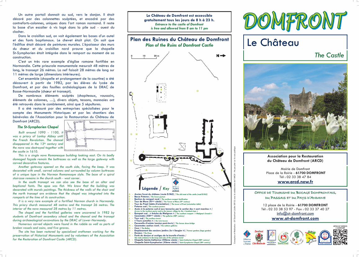
Plan des Ruines du Château de Domfront Plan of the Ruins of Domfront Castle
A - Ancien fossé du château (route D.962) / The old moat of the castle (road D.962) B - Basse Poterne / The lower postern C - Bastion du rempart nord / The northern rempart fortification D - Tour de More (XIème siècle) / The Tower of More (XIth century) E - Tour du Prael (table d’orientation) / The tower of Prael (orientation table) F - Poterne sud / The southern postern G - Accès à la poterne sud et aux tanneries par le sentier des « cent marches » / Access to the southern poster and to the tanners village by the « hundred steps » H - Rempart sud : « brèche de Matignon » / The southern rempart : « Matignon’s breach » I - Casemates (XIIIème siècle) / The galleries (XIIIth century) J - Tour sud / The southern tower K - « Tours jumelles » / the twin towers L - Passerelle d’entrée (ancien pont-levis) / The former draw-bridge M - Casemates section nord / The nothern galleries N - Cour / The Bailey O - Emplacement des anciens jardins (le « Saugier ») / Former gardens (Sage garden) P - Donjon / The Keep Q - Porte du donjon et vestiges de la tourelle d’accès / The main entrance to the keep and ruins of the entrance turret
R - Chapelle Sainte-Catherine (XIIIème siècle) / Saint-Catherine Chapel (XIIIth century)
S - Chapelle Saint-Symphorien (XIème siècle) / Saint-Symphorien Chapel (XIIth century)
Légende / Key
0 10 20 m
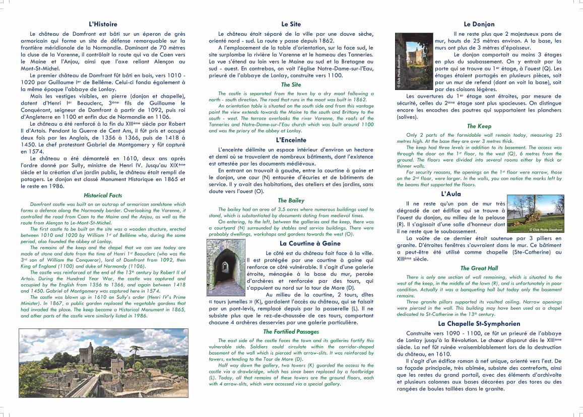
L’Histoire
Le château de Domfront est bâti sur un éperon de grès armoricain qui forme un site de défense remarquable sur la frontière méridionale de la Normandie. Dominant de 70 mètres la cluse de la Varenne, il contrôlait la route qui va de Caen vers le Maine et l’Anjou, ainsi que l’axe reliant Alençon au
Mont-St-Michel. Le premier château de Domfront fût bâti en bois, vers 1010 - 1020 par Guillaume Ier de Bellême. Celui-ci fonda également à la même époque l’abbaye de Lonlay. Mais les vestiges visibles, en pierre (donjon et chapelle),
datent d’Henri Ier Beauclerc, 3ème fils de Guillaume le Conquérant, seigneur de Domfront à partir de 1092, puis roi d’Angleterre en 1100 et enfin duc de Normandie en 1106. Le château a été renforcé à la fin du XIIIème siècle par Robert II d’Artois. Pendant la Guerre de Cent Ans, il fût pris et occupé
deux fois par les Anglais, de 1356 à 1366, puis de 1418 à 1450. Le chef protestant Gabriel de Montgomery y fût capturé en 1574. Le château a été démantelé en 1610, deux ans après l’ordre donné par Sully, ministre de Henri IV. Jusqu’au XIXème
siècle et la création d’un jardin public, le château était rempli de potagers. Le donjon est classé Monument Historique en 1865 et le reste en 1986.
Historical Facts
Domfront castle was built on an outcrop of armorican sandstone which forms a defence along the Normandy border. Overlooking the Varenne, it controlled the road from Caen to the Maine and the Anjou, as well as the route from Alençon to Le-Mont-St-Michel. The first castle to be built on the site was a wooden structure, erected between 1010 and 1020 by William 1st of Bellême who, during the same period, also founded the abbey at Lonlay. The remains of the keep and the chapel that we can see today are made of stone and date from the time of Henri 1st Beauclerc (who was the 3rd son of William the Conqueror), lord of Domfront from 1092, then King of England (1100) and duke of Normandy (1106). The castle was reinforced at the end of the 13th century by Robert II of Artois. During the Hundred Year War, the castle was captured and occupied by the English from 1356 to 1366, and again between 1418 and 1450. Gabriel of Montgomery was captured here in 1574. The castle was blown up in 1610 on Sully’s order (Henri IV’s Prime Minister). In 1867, a public garden replaced the vegetable gardens that had invaded the place. The keep became a Historical Monument in 1865, and other parts of the castle were similarly listed in 1986.
Le Site
Le château était séparé de la ville par une douve sèche, orienté nord - sud. La route y passe depuis 1862. A l’emplacement de la table d’orientation, sur la face sud, le site surplombe la rivière la Varenne et le hameau des Tanneries. La vue s’étend au loin vers le Maine au sud et la Bretagne au
sud - ouest. En contrebas, on voit l’église Notre-Dame-sur-l’Eau, prieuré de l’abbaye de Lonlay, construite vers 1100.
The Site
The castle is separated from the town by a dry moat following a north - south direction. The road that runs in the moat was built in 1862. An orientation table is situated on the south side and from this vantage point the view extends towards the Maine to the south and Brittany to the south - west. The terrace overlooks the river Varenne, the roofs of the Tanneries and Notre-Dame-sur-l’Eau church which was built around 1100 and was the priory of the abbey at Lonlay.
L’Enceinte
L’enceinte délimite un espace intérieur d’environ un hectare
et demi où se trouvaient de nombreux bâtiments, dont l’existence est attestée par les documents médiévaux. En entrant on trouvait à gauche, entre la courtine à gaine et le donjon, une cour (N) entourée d’écuries et de bâtiments de service. Il y avait des habitations, des ateliers et des jardins, sans
doute vers l’ouest (O).
The Bailey
The bailey had an area of 3.5 acres where numerous buildings used to stand, which is substantiated by documents dating from medieval times. On entering, to the left, between the galleries and the keep, there was a courtyard (N) surrounded by stables and service buildings. There were probably dwellings, workshops and gardens towards the west (O).
La Courtine à Gaine
Le côté est du château fait face à la ville. Il est protégée par une courtine à gaine qui renforce ce côté vulnérable. Il s’agit d’une galerie étroite, ménagée à la base du mur, percée
d’archères et renforcée par des tours, qui s’appuient au nord sur la tour de More (D). Au milieu de la courtine, 2 tours, dîtes
« tours jumelles » (K), gardaient l’accès au château, qui se faisait par un pont-levis, remplacé depuis par la passerelle (L). Il ne
subsiste plus que le rez-de-chaussée de ces tours, comportant chacune 4 archères desservies par une galerie particulière.
The Fortified Passages
The east side of the castle faces the town and its galleries fortify this vulnerable side. Soldiers could circulate within the corridor-shaped basement of the wall which is pierced with arrow-slits. It was reinforced by towers, extending to the Tour de More (D). Half way down the gallery, two towers (K) guarded the access to the castle via a drawbridge, which has since been replaced by a footbridge (L). Today, all that remains of these towers are the ground floors, each with 4 arrow-slits, which were accessed via a special gallery.
Le Donjon
Il ne reste plus que 2 majestueux pans de mur, hauts de 25 mètres environ. A la base, les murs ont plus de 3 mètres d’épaisseur. Le donjon comportait au moins 3 étages en plus du soubassement. On y entrait par la
porte qui se trouve au 1er étage, à l’ouest (Q). Les étages étaient partagés en plusieurs pièces, soit par un mur de refend (dont on voit la base), soit par des cloisons légères.
Les ouvertures du 1er étage sont étroites, par mesure de
sécurité, celles du 2ème étage sont plus spacieuses. On distingue encore les encoches des poutres qui supportaient les planchers (solives).
The Keep
Only 2 parts of the formidable wall remain today, measuring 25 metres high. At the base they are over 3 metres thick. The keep had three levels in addition to its basement. The access was through the door on the 1st floor, to the west (Q), 6 metres from the ground. The floors were divided into several rooms either by thick or thinner walls. For security reasons, the openings on the 1st floor were narrow, those on the 2nd floor, were larger. In the walls, you can notice the marks left by the beams that supported the floors.
L’Aula
Il ne reste qu’un pan de mur très dégradé de cet édifice qui se trouve à l’ouest du donjon, au milieu de la pelouse (R). Il s’agissait d’une salle d’honneur dont
il ne reste que le soubassement. La voûte de ce dernier était soutenue par 3 piliers en granite. D’étroites fenêtres s’ouvraient dans le mur. Ce bâtiment a peut-être été utilisé comme chapelle (Ste-Catherine) au XIIIème siècle.
The Great Hall
There is only one section of wall remaining, which is situated to the west of the keep, in the middle of the lawn (R), and is unfortunately in poor condition. Actually it was a banqueting hall but today only the basement remains. Three granite pillars supported its vaulted ceiling. Narrow openings were pierced in the wall. This building may have been used as a chapel dedicated to St-Catherine in the 13th century.
La Chapelle St-Symphorien
Construite vers 1090 - 1100, ce fût un prieuré de l’abbaye de Lonlay jusqu’à la Révolution. Le chœur disparut dès le XIIIème siècle. La nef fût ruinée vraisemblablement lors de la destruction
du château, en 1610. Il s’agit d’un édifice roman à nef unique, orienté vers l’est. De sa façade principale, très abîmée, subsiste des contreforts, ainsi que les restes du grand portail, avec des éléments d’archivolte et plusieurs colonnes aux bases décorées par des tores ou des
rangées de boules taillées dans le granite.
© Club Photo Domfront
© C
lub P
hoto
Dom
front
© C
lub P
hoto
Dom
front
© Club Photo Domfront