Embed Size (px)
Citation preview
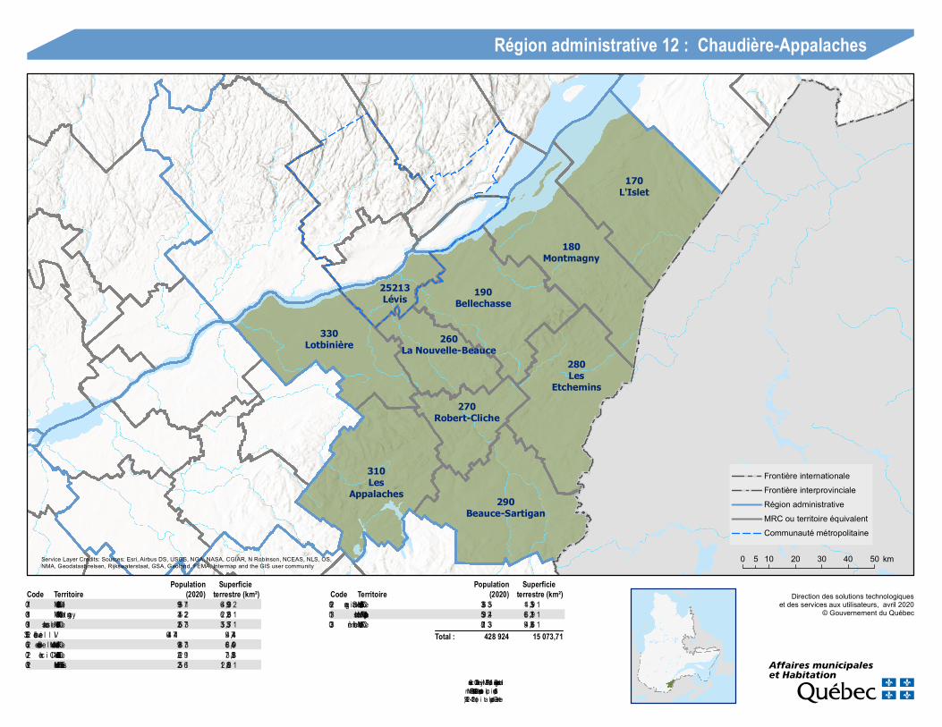
170L'Islet
25213Lévis
180Montmagny
190Bellechasse
330Lotbinière
280Les
Etchemins
260La Nouvelle-Beauce
270Robert-Cliche
310Les
Appalaches 290Beauce-Sartigan
Direction des solutions technologiqueset des services aux utilisateurs, avril 2020
© Gouvernement du Québec
0 10 20 30 40 505 km
Région administrative 12 : Chaudière-Appalaches
Frontière internationaleFrontière interprovincialeRégion administrativeMRC ou territoire équivalentCommunauté métropolitaine
290 MRC de Beauce-Sartigan 53 633 1 953,41310 MRC des Appalaches 42 935 1 912,66330 MRC de Lotbinière 33 128 1 663,49
Total : 428 924 15 073,71
Code Territoire (2020)Population
terrestre (km²)Superficie
Code Territoire (2020)Population
terrestre (km²)Superficie
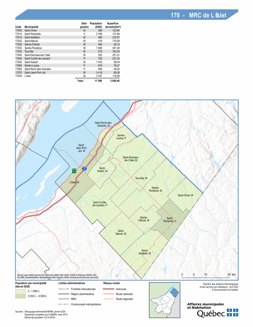
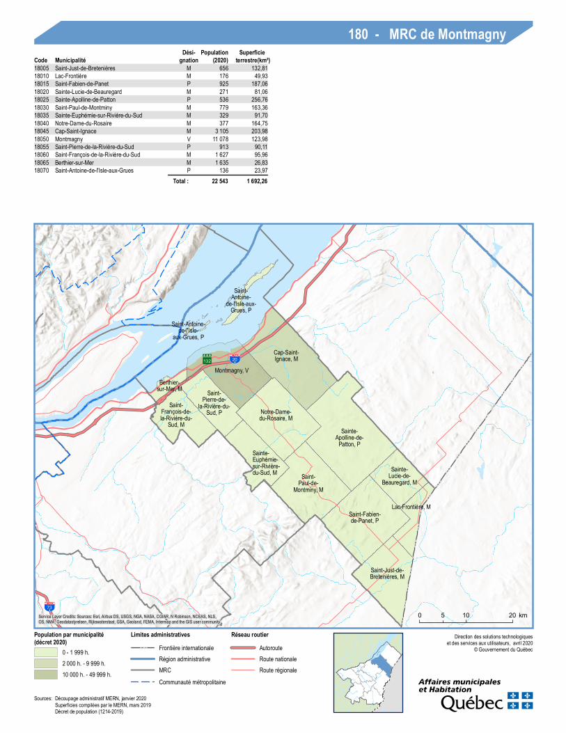
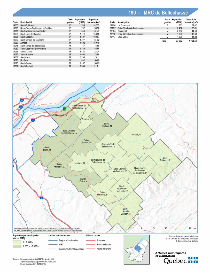
170 MRC de L’Islet 17 599 2 099,46180 MRC de Montm agn y 22 543 1 692,26190 MRC de Bellechas se 37 652 1 753,5325213 Ville de Lévis 147 440 447,49260 MRC de La Nouvelle-Beauce 37 889 904,86270 MRC de Robert-Cliche 19 262 838,37280 MRC des Etchem in s 16 532 1 808,21
Sources:Découpage ad m inistratif MERN, jan vier 2020Superficies com pilées par le MERN, m ars 2019Décret de population (1214-2019)
Service Layer Credits: Sources: Esri, Airbus DS, USGS, NGA, NASA, CGIAR, N Robinson, NCEAS, NLS, OS,NMA, Geodatastyrelsen, Rijkswaterstaat, GSA, Geoland, FEMA, Intermap and the GIS user community
13220
L'Islet, M
Saint-Jean-Port-
Joli, M
Saint-Roch-des-Aulnaies, M
Sainte-Louise, P
Saint-Aubert, M
Saint-Cyrille-de-Lessard, P
Saint-Damase-de-L'Islet, M
Tourville, M
Sainte-Perpétue, M
Sainte-Félicité, M
Saint-Marcel, M
Saint-Adalbert, M
Saint-Pamphile, V
Saint-Omer, M
0 10 205 km
Direction des solutions technologiqueset des services aux utilisateurs, avril 2020
© Gouvernement du Québec
Popu lation par municipalité(décret 2020)
0 - 1 999 h.2 000 h. - 9 999 h.
Limites administrativesFrontière internationaleRégion administrativeMRCCommunauté métropolitaine
Réseau rou tierAutorouteRoute nationaleRoute régionale
Service Layer Credits: Sources: Esri, Airbus DS, USGS, NGA, NASA, CGIAR, N Robinson, NCEAS, NLS,OS, NMA, Geodatastyrelsen, Rijkswaterstaat, GSA, Geoland, FEMA, Intermap and the GIS user community
170 - MRC de L’IsletCode Municipalité
Dési-gnation (2020)
Popu lationterrestre(km²)Superficie
17005 Saint-Omer M 268 122,6417010 Saint-Pamphile V 2 358 137,8517015 Saint-Adalbert M 485 216,5717020 Saint-Marcel M 418 179,0917025 Sainte-Félicité M 364 94,1917030 Sainte-Perpétue M 1 588 291,0017035 Tourville M 579 163,3917040 Saint-Damase-de-L'Islet M 535 251,0117045 Saint-Cyrille-de-Lessard P 729 231,0217055 Saint-Aubert M 1 453 98,0417060 Sainte-Louise P 679 76,2717065 Saint-Roch-des-Aulnaies P 938 49,0217070 Saint-Jean-Port-Joli M 3 418 69,3817078 L'Islet M 3 787 119,99
Total : 17 599 2 099,46
Sources: Découpage administratif MERN, janvier 2020Superficies compilées par le MERN, mars 2019Décret de population (1214-2019)
132
73
20
Saint-Antoine-
de-l'Isle-aux-Grues, P
Saint-Antoine-de-l'Isle-
aux-Grues, P
Saint-Fabien-de-Panet, P
Lac-Frontière, M
Saint-Just-de-Bretenières, M
Berthier-sur-Mer, M
Saint-François-de-la-Rivière-du-
Sud, M
Saint-Pierre-de-
la-Rivière-du-Sud, P
Montmagny, V
Cap-Saint-Ignace, M
Notre-Dame-du-Rosaire, M
Sainte-Euphémie-sur-Rivière-du-Sud, M Saint-
Paul-de-Montminy, M
Sainte-Apolline-de-
Patton, P
Sainte-Lucie-de-
Beauregard, M
0 10 205 km
Direction des solutions technologiqueset des services aux utilisateurs, avril 2020
© Gouvernement du Québec
Population par municipalité(décret 2020)
0 - 1 999 h.2 000 h. - 9 999 h.10 000 h. - 49 999 h.
Limites administrativesFrontière internationaleRégion administrativeMRCCommunauté métropolitaine
Réseau routierAutorouteRoute nationaleRoute régionale
Service Layer Credits: Sources: Esri, Airbus DS, USGS, NGA, NASA, CGIAR, N Robinson, NCEAS, NLS,OS, NMA, Geodatastyrelsen, Rijkswaterstaat, GSA, Geoland, FEMA, Intermap and the GIS user community
180 - MRC de MontmagnyCode Municipalité
Dési-gnation (2020)
Populationterrestre(km²)
Superficie
18005 Saint-Just-de-Bretenières M 656 132,8118010 Lac-Frontière M 176 49,9318015 Saint-Fabien-de-Panet P 925 187,0618020 Sainte-Lucie-de-Beauregard M 271 81,0618025 Sainte-Apolline-de-Patton P 536 256,7618030 Saint-Paul-de-Montminy M 779 163,3618035 Sainte-Euphémie-sur-Rivière-du-Sud M 329 91,7018040 Notre-Dame-du-Rosaire M 377 164,7518045 Cap-Saint-Ignace M 3 105 203,9818050 Montmagny V 11 078 123,9818055 Saint-Pierre-de-la-Rivière-du-Sud P 913 90,1118060 Saint-François-de-la-Rivière-du-Sud M 1 627 95,9618065 Berthier-sur-Mer M 1 635 26,8318070 Saint-Antoine-de-l'Isle-aux-Grues P 136 23,97
Total : 22 543 1 692,26
Sources: Découpage administratif MERN, janvier 2020Superficies compilées par le MERN, mars 2019Décret de population (1214-2019)
132440
40
20
73
Saint-Vallier, M
Saint-Michel-de-Bellechasse, M
Beaumont, M
Saint-Charles-de-Bellechasse, M
La Durantaye, PSaint-
Raphaël, M
Saint-Gervais, M
Honfleur, M
Saint-Henri, M
Saint-Anselme, M
Sainte-Claire, M
Saint-Lazare-de-Bellechasse, M
Saint-Nérée-de-Bellechasse, M
Armagh, M
Saint-Damien-de-Buckland, P
Saint-Malachie, P
Saint-Léon-de-
Standon, P
Saint-Nazaire-de-
Dorchester, P
Notre-Dame-Auxiliatrice-
de-Buckland, P
Saint-Philémon, P
0 10 205 km
Direction des solutions technologiqueset des services aux utilisateurs, avril 2020
© Gouvernement du Québec
Population par municipalité(décret 2020)
0 - 1 999 h.2 000 h. - 9 999 h.
Limites administrativesRégion administrativeMRCCommunauté métropolitaine
Réseau routierAutorouteRoute nationaleRoute régionale
Service Layer Credits: Sources: Esri, Airbus DS, USGS, NGA, NASA, CGIAR, N Robinson, NCEAS, NLS,OS, NMA, Geodatastyrelsen, Rijkswaterstaat, GSA, Geoland, FEMA, Intermap and the GIS user community
190 - MRC de BellechasseCode Municipalité
Dési-gnation (2020)
Populationterrestre(km²)
SuperficieCode Municipalité
Dési-gnation (2020)
Populationterrestre(km²)
Superficie
19005 Saint-Philémon P 709 147,3319010 Notre-Dame-Auxiliatrice-de-Buckland P 757 96,3019015 Saint-Nazaire-de-Dorchester P 355 51,4719020 Saint-Léon-de-Standon P 1 110 136,8019025 Saint-Malachie P 1 527 100,9719030 Saint-Damien-de-Buckland P 1 877 81,9219037 Armagh M 1 502 169,1919045 Saint-Nérée-de-Bellechasse M 737 75,6619050 Saint-Lazare-de-Bellechasse M 1 319 85,6619055 Sainte-Claire M 3 484 88,2419062 Saint-Anselme M 4 000 73,9819068 Saint-Henri M 5 705 123,1119070 Honfleur M 882 50,8019075 Saint-Gervais M 2 197 90,0519082 Saint-Raphaël M 2 345 121,21
19090 La Durantaye P 781 34,4219097 Saint-Charles-de-Bellechasse M 2 492 93,6119105 Beaumont M 2 984 44,5319110 Saint-Michel-de-Bellechasse M 1 804 43,4019117 Saint-Vallier M 1 085 44,88
Total : 37 652 1 753,53
Sources: Découpage administratif MERN, janvier 2020Superficies compilées par le MERN, mars 2019Décret de population (1214-2019)
138
132
175
138
132
973
540
740
573
440
40
20
73
Lévis, V
0 105 km
Direction des solutions technologiqueset des services aux utilisateurs, avril 2020
© Gouvernement du Québec
Population par municipalité(décret 2020)
100 000 h. - 2 000 000 h.
Limites administrativesRégion administrativeMRCCommunauté métropolitaine
Réseau routierAutorouteRoute nationaleRoute régionale
Service Layer Credits: Sources: Esri, Airbus DS, USGS, NGA, NASA, CGIAR, N Robinson, NCEAS, NLS,OS, NMA, Geodatastyrelsen, Rijkswaterstaat, GSA, Geoland, FEMA, Intermap and the GIS user community
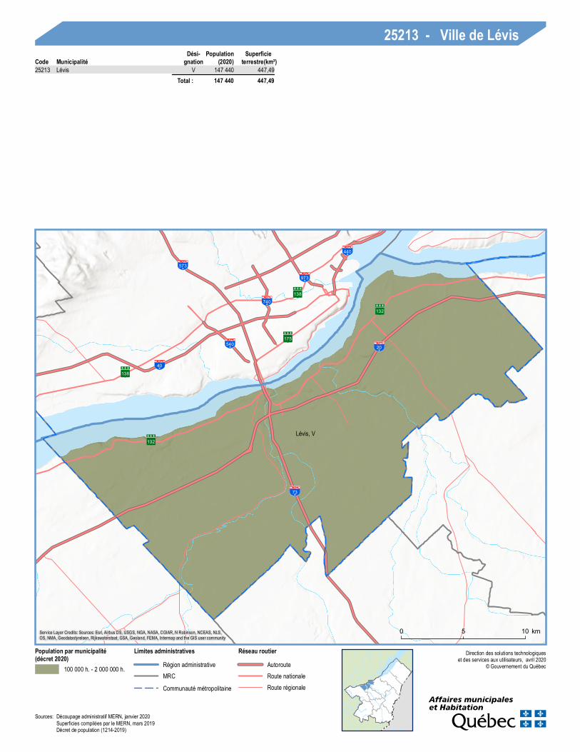
25213 - Ville de LévisCode Municipalité
Dési-gnation (2020)
Populationterrestre(km²)
Superficie
25213 Lévis V 147 440 447,49 Total : 147 440 447,49
Sources: Découpage administratif MERN, janvier 2020Superficies compilées par le MERN, mars 2019Décret de population (1214-2019)
73
Saint-Lambert-de-Lauzon, M Saint-
Isidore, M
Saint-Bernard, M
Scott, M
Sainte-Hénédine, P
Sainte-Marguerite, P
Sainte-Marie, V
Saint-Elzéar, M
Vallée-Jonction, M
Saints-Anges, P
Frampton, M
0 105 km
Direction des solutions technologiqueset des services aux utilisateurs, avril 2020
© Gouvernement du Québec
Population par municipalité(décret 2020)
0 - 1 999 h.2 000 h. - 9 999 h.10 000 h. - 49 999 h.
Limites administrativesMRCCommunauté métropolitaine
Réseau routierAutorouteRoute nationaleRoute régionale
Service Layer Credits: Sources: Esri, Airbus DS, USGS, NGA, NASA, CGIAR, N Robinson, NCEAS, NLS,OS, NMA, Geodatastyrelsen, Rijkswaterstaat, GSA, Geoland, FEMA, Intermap and the GIS user community
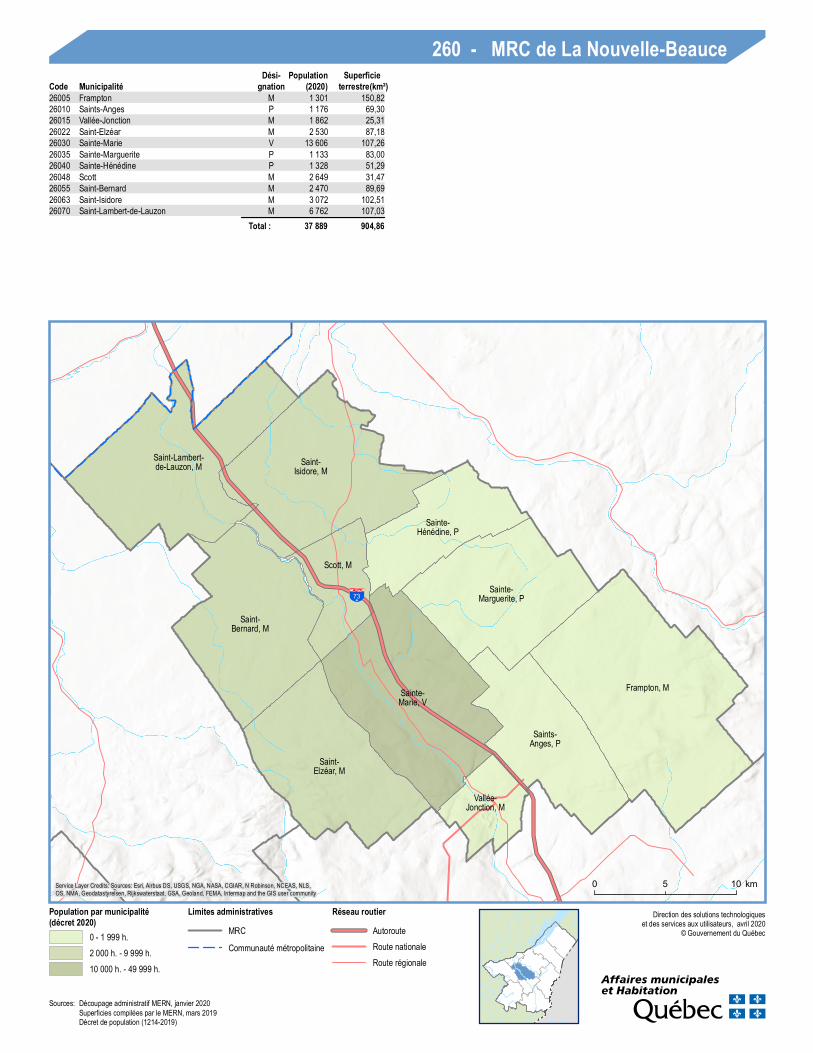
260 - MRC de La Nouvelle-BeauceCode Municipalité
Dési-gnation (2020)
Populationterrestre(km²)
Superficie
26005 Frampton M 1 301 150,8226010 Saints-Anges P 1 176 69,3026015 Vallée-Jonction M 1 862 25,3126022 Saint-Elzéar M 2 530 87,1826030 Sainte-Marie V 13 606 107,2626035 Sainte-Marguerite P 1 133 83,0026040 Sainte-Hénédine P 1 328 51,2926048 Scott M 2 649 31,4726055 Saint-Bernard M 2 470 89,6926063 Saint-Isidore M 3 072 102,5126070 Saint-Lambert-de-Lauzon M 6 762 107,03
Total : 37 889 904,86
Sources: Découpage administratif MERN, janvier 2020Superficies compilées par le MERN, mars 2019Décret de population (1214-2019)
11273
Saint-Séverin, P
Saint-Frédéric, P
Tring-Jonction, VL
Saint-Jules, P
Saint-Joseph-des-Érables, M
Saint-Joseph-de-Beauce, V
Saint-Odilon-de-
Cranbourne, P
Beauceville, V
Saint-Alfred, MSaint-
Victor, M
0 105 km
Direction des solutions technologiqueset des services aux utilisateurs, avril 2020
© Gouvernement du Québec
Population par municipalité(décret 2020)
0 - 1 999 h.2 000 h. - 9 999 h.
Limites administrativesMRC
Réseau routierAutorouteRoute nationaleRoute régionale
Service Layer Credits: Sources: Esri, Airbus DS, USGS, NGA, NASA, CGIAR, N Robinson, NCEAS, NLS,OS, NMA, Geodatastyrelsen, Rijkswaterstaat, GSA, Geoland, FEMA, Intermap and the GIS user community
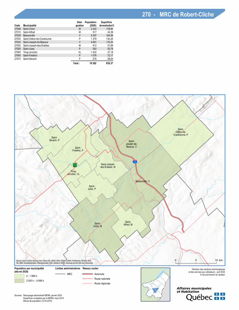
270 - MRC de Robert-ClicheCode Municipalité
Dési-gnation (2020)
Populationterrestre(km²)
Superficie
27008 Saint-Victor M 2 442 119,5027015 Saint-Alfred M 517 43,3927028 Beauceville V 6 297 164,5627035 Saint-Odilon-de-Cranbourne P 1 379 130,2527043 Saint-Joseph-de-Beauce V 4 891 115,2427050 Saint-Joseph-des-Érables M 412 51,6627055 Saint-Jules P 550 55,7827060 Tring-Jonction VL 1 422 27,1827065 Saint-Frédéric P 1 076 72,1727070 Saint-Séverin P 276 58,64
Total : 19 262 838,37
Sources: Découpage administratif MERN, janvier 2020Superficies compilées par le MERN, mars 2019Décret de population (1214-2019)
73
Saint-Magloire, M
Saint-Camille-de-Lellis, P
Sainte-Sabine, P
Saint-Luc-de-Bellechasse, M
Lac-Etchemin, MSainte-
Justine, M
Saint-Cyprien, P
Saint-Louis-de-Gonzague, M
Sainte-Rose-de-
Watford, MSaint-
Benjamin, M
Saint-Prosper, M
Sainte-Aurélie, M
Saint-Zacharie, M
0 10 205 km
Direction des solutions technologiqueset des services aux utilisateurs, avril 2020
© Gouvernement du Québec
Population par municipalité(décret 2020)
0 - 1 999 h.2 000 h. - 9 999 h.
Limites administrativesFrontière internationaleMRC
Réseau routierAutorouteRoute nationaleRoute régionale
Service Layer Credits: Sources: Esri, Airbus DS, USGS, NGA, NASA, CGIAR, N Robinson, NCEAS, NLS,OS, NMA, Geodatastyrelsen, Rijkswaterstaat, GSA, Geoland, FEMA, Intermap and the GIS user community
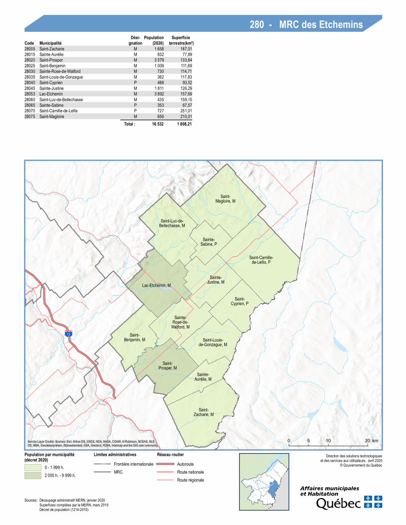
280 - MRC des EtcheminsCode Municipalité
Dési-gnation (2020)
Populationterrestre(km²)
Superficie
28005 Saint-Zacharie M 1 658 187,0128015 Sainte-Aurélie M 832 77,8928020 Saint-Prosper M 3 579 133,6428025 Saint-Benjamin M 1 009 111,8928030 Sainte-Rose-de-Watford M 730 114,7128035 Saint-Louis-de-Gonzague M 362 117,8328040 Saint-Cyprien P 488 93,5228045 Sainte-Justine M 1 811 126,2928053 Lac-Etchemin M 3 892 157,6928060 Saint-Luc-de-Bellechasse M 435 159,1528065 Sainte-Sabine P 353 67,5728070 Saint-Camille-de-Lellis P 727 251,0128075 Saint-Magloire M 656 210,01
Total : 16 532 1 808,21
Sources: Découpage administratif MERN, janvier 2020Superficies compilées par le MERN, mars 2019Décret de population (1214-2019)
173
73
Saint-Sim on-les-Mines, M
Notre-Dame-des-Pins, P
Saint-Éph rem-de-Beau ce, M
Saint-Benoît-Labre, M
Lac-Pou lin, VL Saint-Georg es, V
Saint-Ph ilibert, M
Saint-Côme--Linière, M
Saint-René, P
Saint-Martin, P
Saint-Honoré-de-Shenley, M
La Gu adelou pe, VL
Saint-Évariste-de-Forsyth, M
Saint-Hilaire-de-Dorset, P Saint-Géd éon-
de-Beau ce, M
Saint-Th éoph ile, M
0 105 km
Direc tion des solu tions tec h nolog iqu eset des services au x u tilisateu rs, avril 2020
© Gouvernement d u Q u ébec
Population par municipalité(décret 2020)
0 - 1 999 h.2 000 h. - 9 999 h.10 000 h. - 49 999 h.
Limites administrativesFrontière internationaleRég ion ad m inistrativeMRC
Réseau routierAu torou teRou te nationaleRou te rég ionale
Service Layer Cred its: Sou rces: Esri, Airbu s DS, USGS, NGA, NASA, CGIAR, N Robinson, NCEAS, NLS,OS, NMA, Geodatastyrelsen, Rijkswaterstaat, GSA, Geoland, FEMA, Interm ap and th e GIS u ser c om m u nity
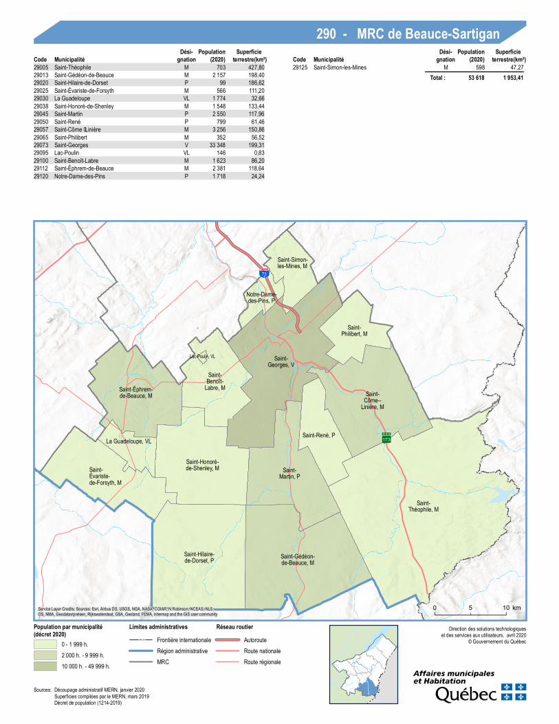
290 - MRC de Beauce-SartiganCode Municipalité
Dési-gnation (2020)
Populationterrestre(km²)
SuperficieCode Municipalité
Dési-gnation (2020)
Populationterrestre(km²)
Superficie
29005 Saint-Th éoph ile M 703 427,8029013 Saint-Géd éon-de-Beau ce M 2 157 198,4029020 Saint-Hilaire-de-Dorset P 99 186,6229025 Saint-Évariste-de-Forsyth M 566 111,2029030 La Gu adelou pe VL 1 774 32,6629038 Saint-Honoré-de-Shenley M 1 548 133,4429045 Saint-Martin P 2 550 117,9629050 Saint-René P 799 61,4629057 Saint-Côme–Linière M 3 256 150,8629065 Saint-Ph ilibert M 352 56,5229073 Saint-Georg es V 33 348 199,3129095 Lac-Pou lin VL 146 0,8329100 Saint-Benoît-Labre M 1 623 86,2029112 Saint-Éph rem-de-Beau ce M 2 381 118,6429120 Notre-Dame-des-Pins P 1 718 24,24
29125 Saint-Sim on-les-Mines M 598 47,27 Total : 53 618 1 953,41
Sou rces:Décou page ad m inistratif MERN, janvier 2020Su perfic ies com pilées par le MERN, mars 2019Décret de popu lation (1214-2019)
161
165
112
73Saint-Jacques-de-
Leeds, M
Saint-Pierre-de-Broughton, M
Sacré-Coeur-de-Jésus, P
East Broughton, MKinnear'sMills, M
Saint-Jean-de-Brébeuf, M
Saint-Adrien-d'Irlande, M
ThetfordMines, V Sainte-
Clotilde-de-Beauce, M
Adstock, M
Sainte-Praxède, P
Saint-Joseph-de-Coleraine, M
Irlande, M
Saint-Julien, M
Saint-Fortunat, M
Saint-Jacques-le-Majeur-de-Wolfestown, P Disraeli, P
Disraeli, V
Beaulac-Garthby, M
0 10 205 km
Direction des solutions technologiqueset des services aux utilisateurs, avril 2020
© Gouvernement du Québec
Population par municipalité(décret 2020)
0 - 1 999 h.2 000 h. - 9 999 h.10 000 h. - 49 999 h.
Limites administrativesRégion administrativeMRC
Réseau routierAutorouteRoute nationaleRoute régionale
Service Layer Credits: Sources: Esri, Airbus DS, USGS, NGA, NASA, CGIAR, N Robinson, NCEAS, NLS,OS, NMA, Geodatastyrelsen, Rijkswaterstaat, GSA, Geoland, FEMA, Intermap and the GIS user community
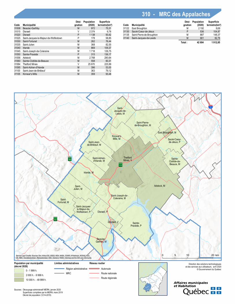
310 - MRC des AppalachesCode Municipalité
Dési-gnation (2020)
Populationterrestre(km²)
SuperficieCode Municipalité
Dési-gnation (2020)
Populationterrestre(km²)
Superficie
31008 Beaulac-Garthby M 972 75,3131015 Disraeli V 2 374 6,7631020 Disraeli P 1 138 93,4231025 Saint-Jacques-le-Majeur-de-Wolfestown P 178 58,8531030 Saint-Fortunat M 262 76,4431035 Saint-Julien M 368 82,5531040 Irlande M 869 109,3731045 Saint-Joseph-de-Coleraine M 1 718 126,7531050 Sainte-Praxède P 315 136,1731056 Adstock M 2 768 290,6431060 Sainte-Clotilde-de-Beauce M 558 60,3131084 Thetford Mines V 25 670 225,9931095 Saint-Adrien-d'Irlande M 396 53,0031100 Saint-Jean-de-Brébeuf M 363 79,1231105 Kinnear's Mills M 359 93,48
31122 East Broughton M 2 192 8,6931130 Sacré-Coeur-de-Jésus P 536 104,8731135 Saint-Pierre-de-Broughton M 887 148,3731140 Saint-Jacques-de-Leeds M 681 82,76
Total : 42 604 1 912,85
Sources: Découpage administratif MERN, janvier 2020Superficies compilées par le MERN, mars 2019Décret de population (1214-2019)
138
132 73
40
20
Leclercville, M
Lotbinière, M Sainte-Croix, M
Saint-Antoine-de-Tilly, M
Saint-Apollinaire, M
Notre-Dame-du-Sacré-Coeur-
d'Issoudun, PSaint-Édouard-de-
Lotbinière, P
Val-Alain, M
Saint-Janvier-
de-Joly, M
Laurier-Station, VL
Saint-Flavien, M
Saint-Agapit, M
Dosquet, M
Saint-Gilles, M Saint-Narcisse-de-
Beaurivage, P
Saint-Patrice-de-Beaurivage, M
Sainte-Agathe-de-Lotbinière, M
Saint-Sylvestre, M
0 105 km
Direction des solutions technologiqueset des services aux utilisateurs, avril 2020
© Gouvernement du Québec
Population par municipalité(décret 2020)
0 - 1 999 h.2 000 h. - 9 999 h.
Limites administrativesRégion administrativeMRCCommunauté métropolitaine
Réseau routierAutorouteRoute nationaleRoute régionaleLocale
Service Layer Credits: Sources: Esri, Airbus DS, USGS, NGA, NASA, CGIAR, N Robinson, NCEAS, NLS,OS, NMA, Geodatastyrelsen, Rijkswaterstaat, GSA, Geoland, FEMA, Intermap and the GIS user community
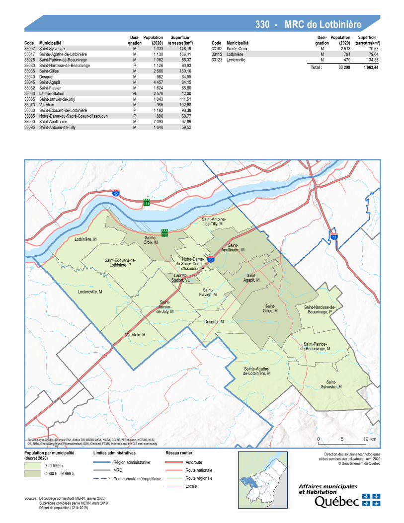
330 - MRC de LotbinièreCode Municipalité
Dési-gnation (2020)
Populationterrestre(km²)
SuperficieCode Municipalité
Dési-gnation (2020)
Populationterrestre(km²)
Superficie
33007 Saint-Sylvestre M 1 033 148,1933017 Sainte-Agathe-de-Lotbinière M 1 130 166,4133025 Saint-Patrice-de-Beaurivage M 1 062 85,3733030 Saint-Narcisse-de-Beaurivage P 1 126 60,9333035 Saint-Gilles M 2 686 180,1633040 Dosquet M 982 64,5533045 Saint-Agapit M 4 457 64,1533052 Saint-Flavien M 1 624 65,8033060 Laurier-Station VL 2 576 12,0033065 Saint-Janvier-de-Joly M 1 043 111,5133070 Val-Alain M 985 102,6833080 Saint-Édouard-de-Lotbinière P 1 192 98,3833085 Notre-Dame-du-Sacré-Coeur-d'Issoudun P 886 60,7733090 Saint-Apollinaire M 7 093 97,8933095 Saint-Antoine-de-Tilly M 1 640 59,52
33102 Sainte-Croix M 2 513 70,6333115 Lotbinière M 791 79,6433123 Leclercville M 479 134,86
Total : 33 298 1 663,44
Sources: Découpage administratif MERN, janvier 2020Superficies compilées par le MERN, mars 2019Décret de population (1214-2019)