Embed Size (px)
Citation preview
Preliminary Report
The 10 April 2021 (Mw 6.1) South of East Java Destructive Earthquake, Indonesia
Pepen Supendi, Rahmat Triyono, Dadang Permana, Makmuri, Sujabar, Khudori, Ikhsan, Dwikorita Karnawati
Meteorological, Climatological, and Geophysical Agency (BMKG)
Jl. Angkasa 1 No. 2 Kemayoran, Jakarta 10720, Indonesia
Telp. (+62 21) 4246321, Fax: (+62 21) 4246703, Website: http://www.bmkg.go.id
April 2021
Table of Contents
1. Introduction ........................................................................................................................................ 1
2. Impact of the Earthquake and Field Survey ...................................................................................... 2
3. Historical of Destructive Earthquakes in South of Java .................................................................... 6
4. Earthquake Source Mechanism and Aftershocks .............................................................................. 7
5. Concluding Remarks ........................................................................................................................... 8
References .............................................................................................................................................. 9
Appendix ............................................................................................................................................... 10
1
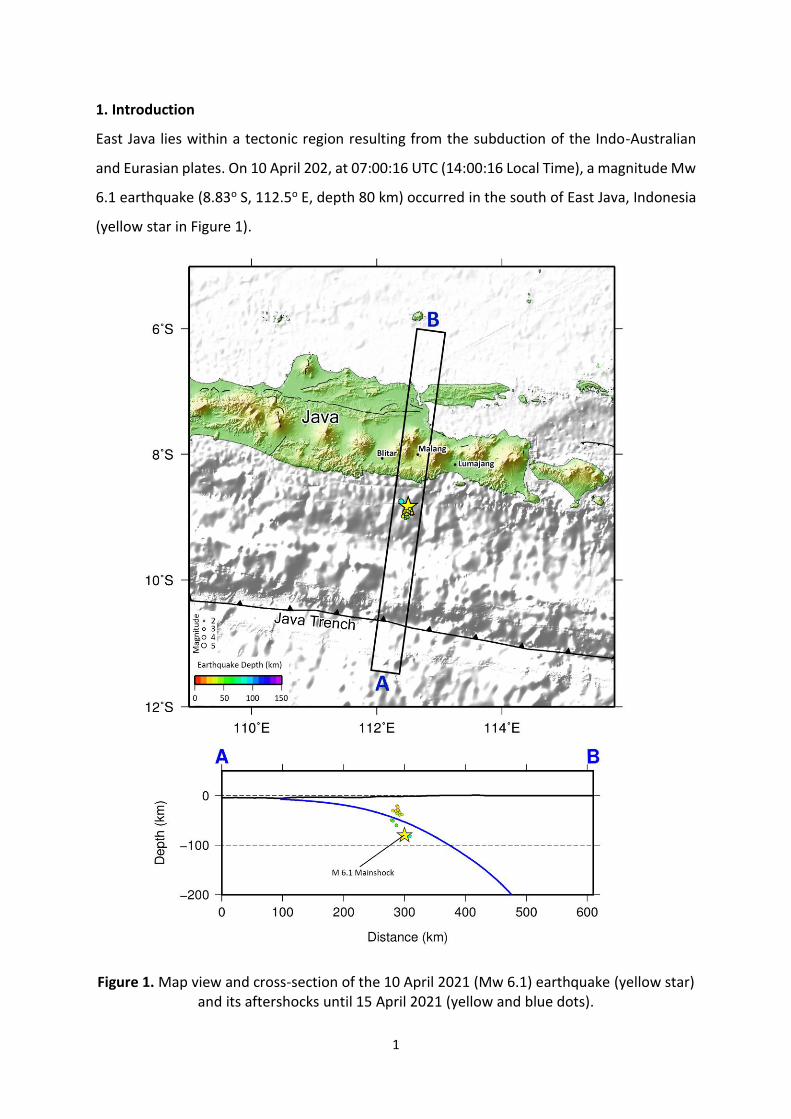
1. Introduction
East Java lies within a tectonic region resulting from the subduction of the Indo-Australian
and Eurasian plates. On 10 April 202, at 07:00:16 UTC (14:00:16 Local Time), a magnitude Mw
6.1 earthquake (8.83o S, 112.5o E, depth 80 km) occurred in the south of East Java, Indonesia
(yellow star in Figure 1).
Figure 1. Map view and cross-section of the 10 April 2021 (Mw 6.1) earthquake (yellow star) and its aftershocks until 15 April 2021 (yellow and blue dots).
2
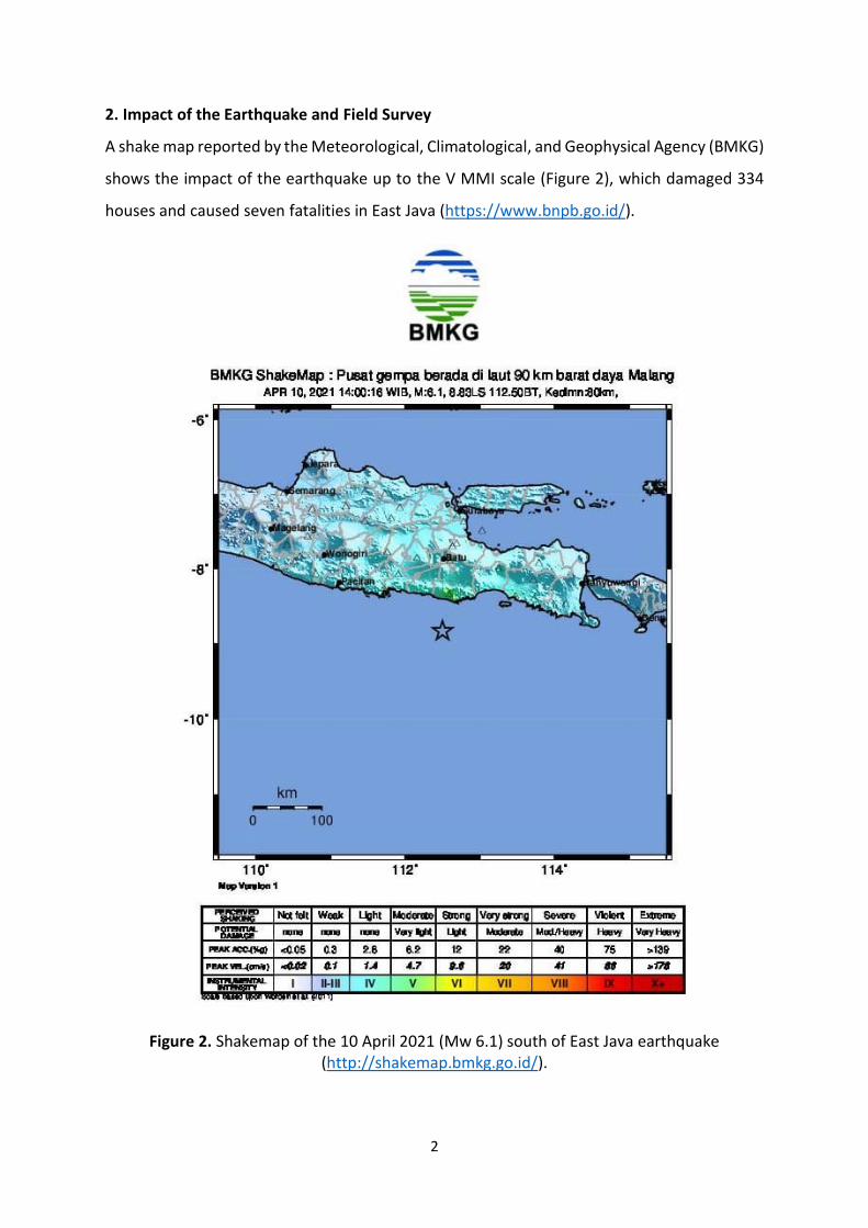
2. Impact of the Earthquake and Field Survey
A shake map reported by the Meteorological, Climatological, and Geophysical Agency (BMKG)
shows the impact of the earthquake up to the V MMI scale (Figure 2), which damaged 334
houses and caused seven fatalities in East Java (https://www.bnpb.go.id/).
Figure 2. Shakemap of the 10 April 2021 (Mw 6.1) south of East Java earthquake (http://shakemap.bmkg.go.id/).
3
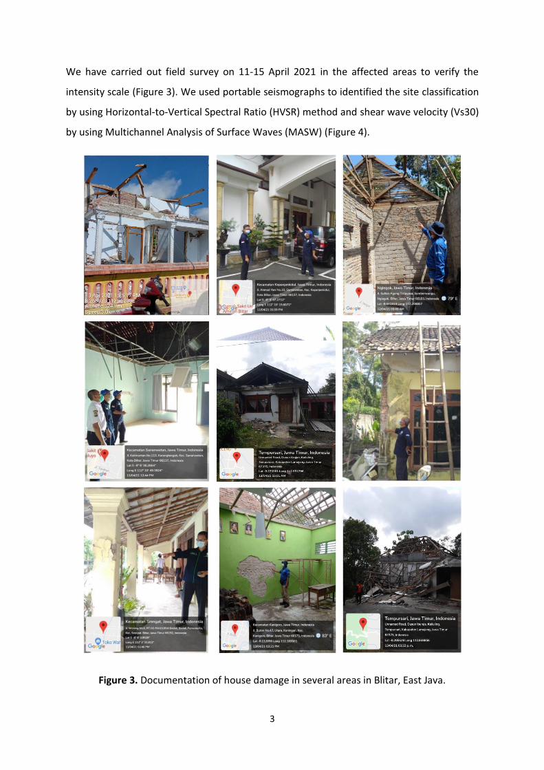
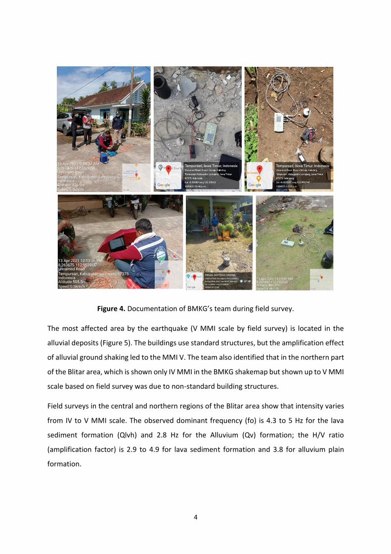
We have carried out field survey on 11-15 April 2021 in the affected areas to verify the
intensity scale (Figure 3). We used portable seismographs to identified the site classification
by using Horizontal-to-Vertical Spectral Ratio (HVSR) method and shear wave velocity (Vs30)
by using Multichannel Analysis of Surface Waves (MASW) (Figure 4).
Figure 3. Documentation of house damage in several areas in Blitar, East Java.
4
Figure 4. Documentation of BMKG’s team during field survey.
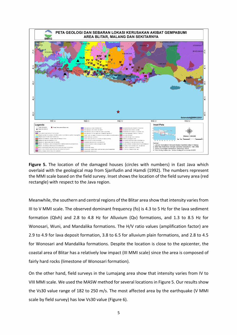
The most affected area by the earthquake (V MMI scale by field survey) is located in the
alluvial deposits (Figure 5). The buildings use standard structures, but the amplification effect
of alluvial ground shaking led to the MMI V. The team also identified that in the northern part
of the Blitar area, which is shown only IV MMI in the BMKG shakemap but shown up to V MMI
scale based on field survey was due to non-standard building structures.
Field surveys in the central and northern regions of the Blitar area show that intensity varies
from IV to V MMI scale. The observed dominant frequency (fo) is 4.3 to 5 Hz for the lava
sediment formation (Qlvh) and 2.8 Hz for the Alluvium (Qv) formation; the H/V ratio
(amplification factor) is 2.9 to 4.9 for lava sediment formation and 3.8 for alluvium plain
formation.
5
Figure 5. The location of the damaged houses (circles with numbers) in East Java which overlaid with the geological map from Sjarifudin and Hamdi (1992). The numbers represent the MMI scale based on the field survey. Inset shows the location of the field survey area (red rectangle) with respect to the Java region.
Meanwhile, the southern and central regions of the Blitar area show that intensity varies from
III to V MMI scale. The observed dominant frequency (fo) is 4.3 to 5 Hz for the lava sediment
formation (Qlvh) and 2.8 to 4.8 Hz for Alluvium (Qv) formations, and 1.3 to 8.5 Hz for
Wonosari, Wuni, and Mandalika formations. The H/V ratio values (amplification factor) are
2.9 to 4.9 for lava deposit formation, 3.8 to 6.5 for alluvium plain formations, and 2.8 to 4.5
for Wonosari and Mandalika formations. Despite the location is close to the epicenter, the
coastal area of Blitar has a relatively low impact (III MMI scale) since the area is composed of
fairly hard rocks (limestone of Wonosari formation).
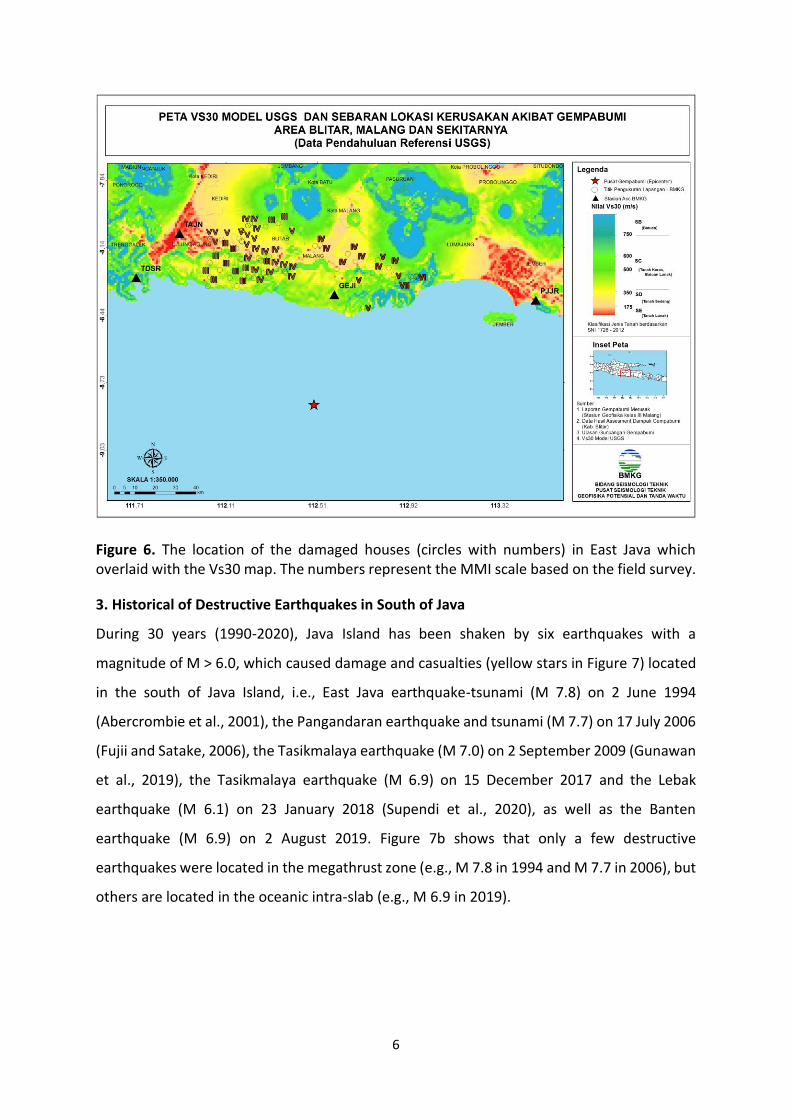
On the other hand, field surveys in the Lumajang area show that intensity varies from IV to
VIII MMI scale. We used the MASW method for several locations in Figure 5. Our results show
the Vs30 value range of 182 to 250 m/s. The most affected area by the earthquake (V MMI
scale by field survey) has low Vs30 value (Figure 6).
6
Figure 6. The location of the damaged houses (circles with numbers) in East Java which overlaid with the Vs30 map. The numbers represent the MMI scale based on the field survey.
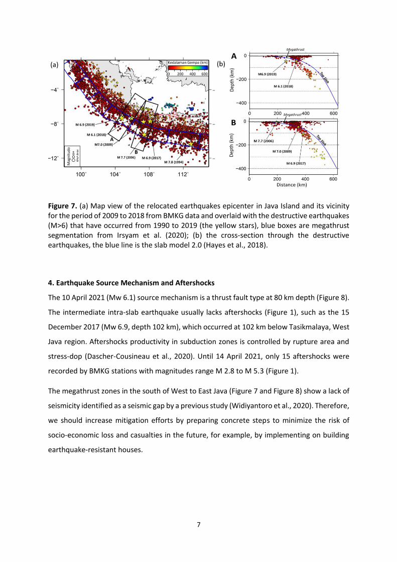
3. Historical of Destructive Earthquakes in South of Java
During 30 years (1990-2020), Java Island has been shaken by six earthquakes with a
magnitude of M > 6.0, which caused damage and casualties (yellow stars in Figure 7) located
in the south of Java Island, i.e., East Java earthquake-tsunami (M 7.8) on 2 June 1994
(Abercrombie et al., 2001), the Pangandaran earthquake and tsunami (M 7.7) on 17 July 2006
(Fujii and Satake, 2006), the Tasikmalaya earthquake (M 7.0) on 2 September 2009 (Gunawan
et al., 2019), the Tasikmalaya earthquake (M 6.9) on 15 December 2017 and the Lebak
earthquake (M 6.1) on 23 January 2018 (Supendi et al., 2020), as well as the Banten
earthquake (M 6.9) on 2 August 2019. Figure 7b shows that only a few destructive
earthquakes were located in the megathrust zone (e.g., M 7.8 in 1994 and M 7.7 in 2006), but
others are located in the oceanic intra-slab (e.g., M 6.9 in 2019).
7
Figure 7. (a) Map view of the relocated earthquakes epicenter in Java Island and its vicinity for the period of 2009 to 2018 from BMKG data and overlaid with the destructive earthquakes (M>6) that have occurred from 1990 to 2019 (the yellow stars), blue boxes are megathrust segmentation from Irsyam et al. (2020); (b) the cross-section through the destructive earthquakes, the blue line is the slab model 2.0 (Hayes et al., 2018).
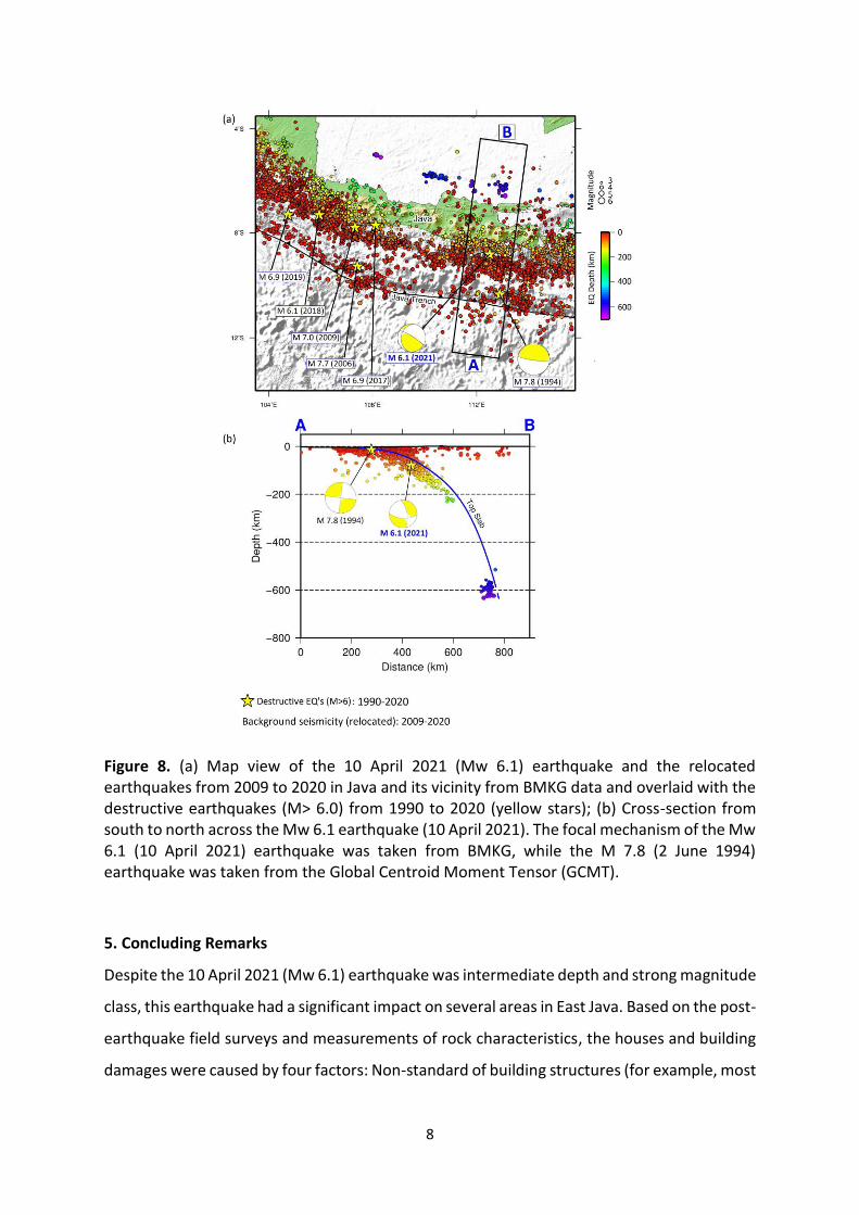
4. Earthquake Source Mechanism and Aftershocks
The 10 April 2021 (Mw 6.1) source mechanism is a thrust fault type at 80 km depth (Figure 8).
The intermediate intra-slab earthquake usually lacks aftershocks (Figure 1), such as the 15
December 2017 (Mw 6.9, depth 102 km), which occurred at 102 km below Tasikmalaya, West
Java region. Aftershocks productivity in subduction zones is controlled by rupture area and
stress-dop (Dascher-Cousineau et al., 2020). Until 14 April 2021, only 15 aftershocks were
recorded by BMKG stations with magnitudes range M 2.8 to M 5.3 (Figure 1).
The megathrust zones in the south of West to East Java (Figure 7 and Figure 8) show a lack of
seismicity identified as a seismic gap by a previous study (Widiyantoro et al., 2020). Therefore,
we should increase mitigation efforts by preparing concrete steps to minimize the risk of
socio-economic loss and casualties in the future, for example, by implementing on building
earthquake-resistant houses.
8
Figure 8. (a) Map view of the 10 April 2021 (Mw 6.1) earthquake and the relocated earthquakes from 2009 to 2020 in Java and its vicinity from BMKG data and overlaid with the destructive earthquakes (M> 6.0) from 1990 to 2020 (yellow stars); (b) Cross-section from south to north across the Mw 6.1 earthquake (10 April 2021). The focal mechanism of the Mw 6.1 (10 April 2021) earthquake was taken from BMKG, while the M 7.8 (2 June 1994) earthquake was taken from the Global Centroid Moment Tensor (GCMT).
5. Concluding Remarks
Despite the 10 April 2021 (Mw 6.1) earthquake was intermediate depth and strong magnitude
class, this earthquake had a significant impact on several areas in East Java. Based on the post-
earthquake field surveys and measurements of rock characteristics, the houses and building
damages were caused by four factors: Non-standard of building structures (for example, most
9
buildings do not use the column structures); local site effect (buildings located on the alluvium
sediment and the lava deposit); local topographic conditions (buildings close to valleys and
slopes); and location distance to the hypocenter.
References
earthquake: Slip over a subducting seamount. J Geophys Res 106:6595–6607. https://doi.org/10.1029/2000JB900403
Dascher‐Cousineau, K., Brodsky, E.E., Lay, T., Goebel, T.H.W. (2020). What Controls Variations in Aftershock Productivity? J Geophys Res Solid Earth 125:. https://doi.org/10.1029/2019JB018111
Fujii, Y., Satake, K. (2006). Source of the July 2006 West Java tsunami estimated from tide gauge records. Geophys Res Lett 33: L24317. https://doi.org/10.1029/2006GL028049
Gunawan, E., Widiyantoro, S., Marliyani, G.I., Sunarti, E., Ida, R., Gusman, A.R. (2019). Fault source of the 2 September 2009 Mw 6.8 Tasikmalaya intraslab earthquake, Indonesia: Analysis from GPS data inversion, tsunami height simulation, and stress transfer. Physics of the Earth and Planetary Interiors 291:54–61. https://doi.org/10.1016/j.pepi.2019.04.004
Hayes, G.P., Moore, G.L., Portner, D.E., Hearne, M., Flamme, H., Furtney, M. & Smoczyk, G.M. (2018). Slab2, a comprehensive subduction zone geometry model. Science, 362, 58–61, https://doi.org/10.1126/science.aat4723.
Irsyam, M., Cummins, P.R., Asrurifak, M., Faizal, F., Natawidjaja, D.H., Widiyantoro, S., Meilano, I., Triyoso, W., Rudiyanto, A., Hidayati, S., Ridwan, M., Hanifa, N.R., Syahbana, A.J. (2020). Development of the 2017 national seismic hazard maps of Indonesia. Earthquake Spectra 875529302095120. https://doi.org/10.1177/8755293020951206
Supendi P., Rohadi, S., Karnawati, D., Nugraha, A.D., Widiyantoro, S., Daryono, Muzli. (2020). Analysis of the destructive earthquakes end of 2017 (Mw 6.9) and early 2018 (Mw 6.1) south of West Java, Indonesia. E3S Web Conf 211:02003. https://doi.org/10.1051/e3sconf/202021102003
Sjarifudin, M.Z., Hamidi, S. (1992). Geology map of Blitar-Java, Research and Development
Center of Geology, Bandung
Widiyantoro, S., Gunawan, E., Muhari, A., Rawlinson, N., Mori, J., Hanifa, N.R., Susilo, S., Supendi, P., Shiddiqi, H.A., Nugraha, A.D., Putra, H.E. (2020). Implications for megathrust earthquakes and tsunamis from seismic gaps south of Java Indonesia. Sci Rep 10:15274. https://doi.org/10.1038/s41598-020-72142-z

10
Appendix
Field Survey Team
BMKG Jakarta
1. Rahmat Triyono
2. Dadang Permana
3. Robby Wallansha
4. Aditya Setyo Rahman
BMKG Pasuruan
1. Sujabar
2. Tofa R.
3. Dwi Wahyudi
4. Deni Rahman
5. Syawaludin
BMKG Karangkates
1. Ken Wirawan
2. Dana Ristanto
BMKG Yogyakarta
1. Ikhsan
2. Ayu
3. Muji