Embed Size (px)
Citation preview
witry & witry S.A.
L-6402 Echternach
T +352..72.88.57-1F +352..72.88.57-99E [email protected]
www.witry-witry.lu
32, rue du Pont I B.P.144
ag1:500
Format
Plancode
A0
Echelle
Projet
Date DessinéDernière Modification
Plan d´aménagement particulier PAP 02/01 - Partie graphique -Belval
03 Belval Sud
06 Parc Belval Sud
02 Square-Mile
01 Terrasse des HautsFourneaux
07 Parc Belval Nord
04 Belval Nord
08 Belvaux Centre
Délimitation du PAPPAP
Nombre d´ étages pleins:
II limite supérieure
I - II limite inférieure et supérieure
II obligatoire
Hauteur des constructions:
hc-x hauteur à la corniche de x m
ha-x hauteur à l´acrotère de x m
hf-x hauteur au faîte de x m
Types et dispositions des constructions:
oc
onc constructions en ordre non contigu
constructions en ordre contigu
mi maisons isolées
mj maisons jumelées
mb maisons en bande
Implantation des immeubles:
Lots privés constructibles
Terrains cédés à la commune
Délimitation de zones différentes (Abgrenzung unterschiedlicher Nutzung)
Délimitation des lots / parcelles:
Degré de mixité des fonctions:
pourcentage minimal de logements par immeublemin x%
x% y% pourcentage minimal et maximal de logements par immeuble
x% pourcentage obligatoire de logements par immeuble
Espaces verts:
espace vert public (affectation spécifiée dans la partie écrite du PAP)EVP
EVp espace vert privé (affectation spécifiée dans la partie écrite du PAP)
ADJ Aires de jeux
plantations existantes
plantations projetées
arbres à conserver
Voies de circulation:
P
rues
aires de stationnement / emplacement publics
chemins piétonniers, "pistes cyclables"
Formes des Toitures:
orientation du faîte
toiture platetp
toiture à x versants, degré d´ inclinaisontx
tm toiture mansardée
éléments bâtis ou naturels à sauvegarder
respect de conditions d´ intégration déterminées
Représentation schématique du degré d´utilisation du sol
XXX II
0,4 0,8
mi t2
Zone définies au PAG
COS - Coefficientd´occupation du sol
Type et Dispositiondes constructions
Nombre d´étages pleins ouHauteur des constructions
CMU - Coefficient maximal d´utilisation du solCUS - Coefficient d´utilisation du sol
Forme des toitures
FOND DE PLAN:
Délimitation des plans directeurs
LÉGENDE-TYPE DU PAP (Art. 25 du RGD)Donnés à titre impératif:
Légende
limites maxima de surfaces constructibles pour constructions principales
limites maxima de surfaces constructibles pour constructions principales
205 10 30 40 50 m
Remarques:
Donnés à titre indicatif
les reseaux principales en manière schématique
bande de éclairage public en manière schématique
alignement obligatoire constructions principales
Prescriptions supplémentaires
alignement obligatoire dépendances
zone d´accès au garages en sous-sol
entrée / sortie du garage en sous-sol
Reconversion de la Friche Belval
limite communale existant
limite communale projeté
zones des plantations des arbres
servitude "droit de superficie" pour le public, voir Chapitre 1.4.5 - Partie écrite du PAP
servitude "droit de superficie" pour le chemin de fer - voir Chapitre 1.4.5 - Partie écrite du PAP
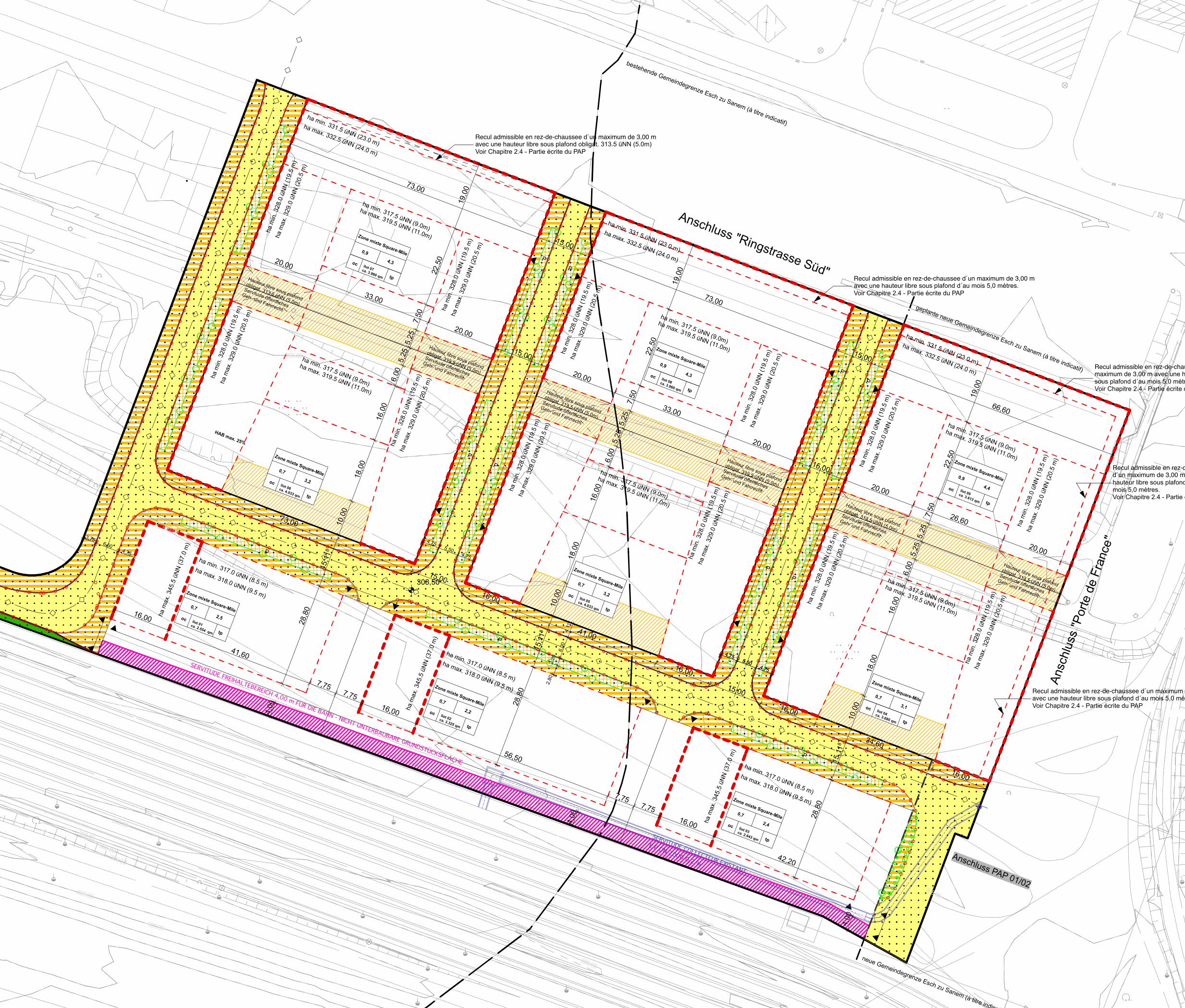
PAP 02/01
1. Base de calcul des coefficients cmu et cos du PAP 02/01:- Un Tableau récapitulatif (Abb. 59) sommaire sous chapitre 3.2 dans la Partie écrite du projet directeur permet l'observation pour le calcul des coefficients conformément le Règlement spécial pour Belval- Ouest.2. Dimensions des parcelles / lots:- La société Agora S.à r.l. & Cie est propriétaire des terrains dont fait l'objet le PAP 02/01. Un extrait cadastral est annexé dans l´exposé des motifs. L´indication des surfaces est donné que titre indicatif. Les dimensions définitives seront fixées par des plans à l´acte à établir par l´administration du cadastre et de la topographie.
WW_BEO_PAP 02/01
26.09.06 08.07.2008
Recul admissible en rez-de-chaussee d´un maximum de 3,00 mavec une hauteur libre sous plafond d´au mois 5,0 mètres.Voir Chapitre 2.4 - Partie écrite du PAP
Recul admissible en rez-de-chaussee d´un maximum de 3,00 mavec une hauteur libre sous plafond d´au mois 5,0 mètres.Voir Chapitre 2.4 - Partie écrite du PAP
Recul admissible en rez-de-chaussee d´un maximum de 3,00 mavec une hauteur libre sous plafond obligat. 313.5 üNN (5.0m)Voir Chapitre 2.4 - Partie écrite du PAP
Recul admissible en rez-de-chaussee d´unmaximum de 3,00 m avec une hauteur libresous plafond d´au mois 5,0 mètres.Voir Chapitre 2.4 - Partie écrite du PAP
Recul admissible en rez-de-chausseed´un maximum de 3,00 m avec unehauteur libre sous plafond d´aumois 5,0 mètres.Voir Chapitre 2.4 - Partie écrite du PAP
ha m
in. 3
28.0
üN
N (1
9.5
m)
ha m
ax. 3
29.0
üN
N (2
0.5
m)
ha m
in. 3
28.0
üN
N (1
9.5
m)
ha m
ax. 3
29.0
üN
N (2
0.5
m)
ha m
in. 3
28.0
üN
N (1
9.5
m)
ha m
in. 3
28.0
üN
N (1
9.5
m)
ha m
ax. 3
29.0
üN
N (2
0.5
m)
ha m
in. 3
28.0
üN
N (1
9.5
m)
ha m
ax. 3
29.0
üN
N (2
0.5
m)
ha m
in. 3
28.0
üN
N (1
9.5
m)
ha m
ax. 3
29.0
üN
N (2
0.5
m)
ha m
in. 3
28.0
üN
N (1
9.5
m)
ha m
ax. 3
29.0
üN
N (2
0.5
m)
ha m
ax. 3
45.5
üN
N (3
7.0
m)
ha m
in. 3
28.0
üN
N (1
9.5
m)
ha m
ax. 3
29.0
üN
N (2
0.5
m)
ha min. 331.5 üNN (23.0 m)
ha min. 317.5 üNN (9.0m)
ha max. 319.5 üNN (11.0m)
ha min. 317.5 üNN (9.0m)
ha max. 319.5 üNN (11.0m)
ha min. 317.5 üNN (9.0m)
ha max. 319.5 üNN (11.0m)
ha min. 317.5 üNN (9.0m)
ha max. 319.5 üNN (11.0m)
ha min. 317.5 üNN (9.0m)
ha max. 319.5 üNN (11.0m)
ha min. 317.5 üNN (9.0m)
ha max. 319.5 üNN (11.0m) ha max. 332.5 üNN (24.0 m)
ha m
ax. 3
45.5
üN
N (3
7.0
m)
ha m
ax. 3
45.5
üN
N (3
7.0
m)
ha min. 331.5 üNN (23.0 m)
ha max. 332.5 üNN (24.0 m)
ha m
in. 3
28.0
üN
N (1
9.5
m)
ha m
ax. 3
29.0
üN
N (2
0.5
m)
ha min. 331.5 üNN (23.0 m)
ha m
ax. 3
29.0
üN
N (2
0.5
m)
ha min. 317.0 üNN (8.5 m)
ha max. 318.0 üNN (9.5 m)
ha min. 317.0 üNN (8.5 m)
ha max. 318.0 üNN (9.5 m)
ha min. 317.0 üNN (8.5 m)
ha max. 318.0 üNN (9.5 m)
Anschluss PAP 01/02
ha m
in. 3
28.0
üN
N (1
9.5
m)
ha m
ax. 3
29.0
üN
N (2
0.5
m)
ha m
in. 3
28.0
üN
N (1
9.5
m)
ha m
ax. 3
29.0
üN
N (2
0.5
m)
ha m
in. 3
28.0
üN
N (1
9.5
m)
ha m
ax. 3
29.0
üN
N (2
0.5
m)
neue Gemeindegrenze Esch zu Sanem (à titre indicatif)
ha max. 332.5 üNN (24.0 m)
Hauteur libre sous plafond
obligat. 313.5 üNN (5.0m)
Servitude öffentliches
Geh- und Fahrrecht
Hauteur libre sous plafond
obligat. 313.5 üNN (5.0m)
Servitude öffentliches
Geh- und Fahrrecht
Hauteur libre sous plafond
obligat. 313.5 üNN (5.0m)
Servitude öffentliches
Geh- und Fahrrecht
Hauteur libre sous plafond
obligat. 313.5 üNN (5.0m)
Servitude öffentliches
Geh- und Fahrrecht
Hauteur libre sous plafond
obligat. 313.5 üNN (5.0m)
Servitude öffentliches
Geh- und Fahrrecht
Hauteur libre sous plafond
obligat. 313.5 üNN (5.0m)
Servitude öffentliches
Geh- und Fahrrecht
geplante neue Gemeindegrenze Esch zu Sanem (à titre indicatif)
bestehende Gemeindegrenze Esch zu Sanem (à titre indicatif)
4,755,50
4,75
16,00
41,60
7,757,75
16,00
56,50
7,757,75
16,00
42,20
5,93
6,50
3,36
3
4,755,50
4,75
4,755,50
4,75
73,00
15,00
73,00
15,00
66,60
20,00
33,00
20,00
15,00
20,00
33,00
20,00
15,00
20,00
26,60
20,00
4,00
4,11
8
6,00
2,20
2,80
4,00
73,00
15,00
16,00
41,00
16,00
15,00
16,00
34,60
16,00
19,0
0
22,5
0
7,50
5,25
5,25
6,00
16,0
0
18,0
0
10,0
0
15,1
18
28,8
0
4,00
19,0
0
22,5
0
7,50
5,25
5,25
6,00
16,0
0
18,0
0
10,0
0
15,1
18
28,8
0
19,0
0
22,5
0
7,50
5,25
5,25
6,00
16,0
0
18,0
0
10,0
0
15,1
18
28,8
0
3,756,50
4,75
308,50
308,50
0,7
oc
tp
3,1
4,3
îlot 05ca. 4.033 qm
îlot 09ca. 3.613 qm
îlot 04ca. 3.680 qm
oc
tp
4,3îlot 07ca. 3.960 qm
oc
tp
îlot 06ca. 4.033 qm
0,7
oc
oc
tp
HAB max. 25%
0,9
P
P
P
4,4
tp
oc
tp
oc
tp
oc
tp
oc
tp
PP
PP
PP
PP
Anschluss "Ringstrasse Süd"
0,7
2,4îlot 03ca. 2.643 qm
îlot 01ca. 2.554 qm
2,2îlot 02ca. 3.325 qm
2,5
Südanbindung Tunnel
Ponts et Chaussées
Südanbindung Tunnel
Ponts et Chaussées
311.00
311.00
310.0
0
310.
00
310.00
309.00
309.00
309.0
0
309.00
309.00308.00
308.00
308.0
0
308.00
308.00
308.00
308.00
308.00
308.00
308.00308.00
308.00
308.00
308.00
308.00
308.
00
308.00
307.00
307.00
307.00
307.00
307.00
307.0
0
306.00
306.00
306.
00
306.00
306.00
305.00
305.00
305.00
305.00
304.00
304.00
304.00
304.00
304.00
304.00
304.00
304.00
304.00
304.00
304.00
304.00
îlot 08ca. 3.960 qm
SERVITUDE COLLECTEUR EXISTANT
E.P DN 2000 0,2 %
0,7
0,7
3,2
0,7
3,2
0,9
0,9
SERVITUDE FREIHALTEBEREICH 4,00 m FÜR DIE BAHN - NICHT UNTERBAUBARE GRUNDSTÜCKSFLÄCHE
Ansc
hlus
s "P
orte
de
Fran
ce"
Zone mixte Square-Mile
Zone mixte Square-Mile
Zone mixte Square-Mile
Zone mixte Square-MileZone mixte Square-Mile
Zone mixte Square-Mile
Zone mixte Square-Mile
Zone mixte Square-Mile
Zone mixte Square-Mile
PAP "Square-Mile" N° 02/01
- LP_362T100A (3D Höhenlinien)_030618.dwg- SA_Grenze_Agora.dwg (Katasterplan)