Embed Size (px)
Citation preview
Bulletin de l’Institut Scientifique, Rabat, Section Sciences de la Terre, 2017, n° 39, 135-139. e-ISSN : 2458-7184
BRIEF NOTE
Effects of the winter storms of 2017 on the Atlantic coast of Rabat:
A preliminary evaluation
Effets des tempêtes hivernales de 2017 sur la côte Atlantique de Rabat :
Evaluation préliminaire
Zaineb BELKHAYAT, Rajae EL AOULA & Nadia MHAMMDI
Geophysics and Natural Hazards Laboratory (LGRN), Institut scientifique; Geophysics, Natural Patrimony and Green
Chemistry Research Center (GEOPAC), University Mohammed V in Rabat, Maroc. ([email protected])
__________________________________________________________________________________________
Abstract. This paper considers the preliminary results of storms effects on the Rabat coast that occurred on 28
February and 1st March, 2017 in Morocco, in order to identify and manage risk coastal areas in the future.
Indeed, the beaches were strongly eroded, the rock fills were destabilized and the constructions have been
flooded and devastated.
Keywords: Storm, Erosion, Coast, Rabat.
Résumé. Cet article présente les résultats préliminaires des effets de tempêtes sur la côte de Rabat au Maroc,
surgies entre le 28 février et le 1er mars 2017, pour but d’identification et de gestion des zones côtières à risque
dans le futur. En effet, les plages ont été fortement érodées, les enrochements ont été déstabilisés et les
constructions ont été submergées et détruites.
Mots-clés: Tempête, Erosion, Côte, Rabat.
__________________________________________________________________________________________
INTRODUCTION
The geographical situation of the Moroccan
coastal cities makes them vulnerable to natural
hazards and extreme events such as storms, tsunamis,
floods and erosion ... In general, statistical data on the
storms that affected the Moroccan coast during the
last century are rare, although some references were
quoted by Simonet & Tanguy (1962), Cherfaoui &
Doghmi (2002), Minoubi et al. (2013) and El
Messaoudi et al. (2016) about storm events that were
generated during the winter, and caused damage to
infrastructures, property and personal injury.
The storms of 28 February and 1st March, 2017
generated waves with 6 to 7 m of significative height
that reached the Moroccan coast between Kenitra and
Tarfaya (National Meteorological Department,
unpublished data). The objective of this short report
is to describe some effects of this storm on buildings
and coastal infrastructure along the coast of Rabat
(34°N; 6°W).
STUDY AREA
The coast of Rabat is located in the north-west of
Morocco, is oriented NE-SW and is mostly composed
of lithified sand dunes parallel to the coastline,
separated by longitudinal cliffs and depressions
(locally called Oulja), transversally cut by the
Bouregreg estuary that separates Rabat from Salé
city.
Morphologically, the barrier beach of Rabat is
characterized by lithified high dunes (probably
ancient spits) eroded frontally by sea cliff. The
southern part of the coast is made in general by small
sandy beaches (Casino, Sables d’Or, Skhirat…)
separated by rocky cliffs and limestone pavement
platforms (South of Temara, Miramar, Guéville).
(Gigout 1957, Akil 1980, Saaidi 1988, Chabli et al.
2003, Akil et al. 2008, Chahid, 2017).
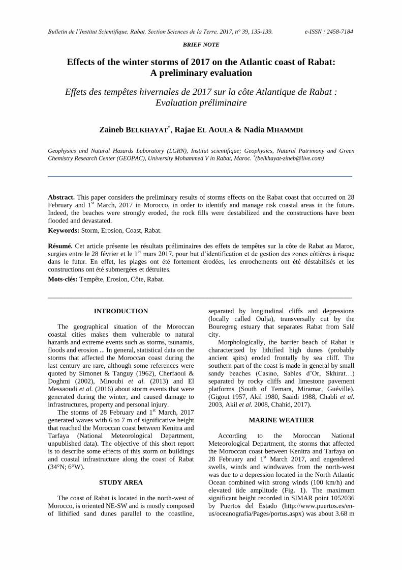
MARINE WEATHER
According to the Moroccan National
Meteorological Department, the storms that affected
the Moroccan coast between Kenitra and Tarfaya on
28 February and 1st March 2017, and engendered
swells, winds and windwaves from the north-west
was due to a depression located in the North Atlantic
Ocean combined with strong winds (100 km/h) and
elevated tide amplitude (Fig. 1). The maximum
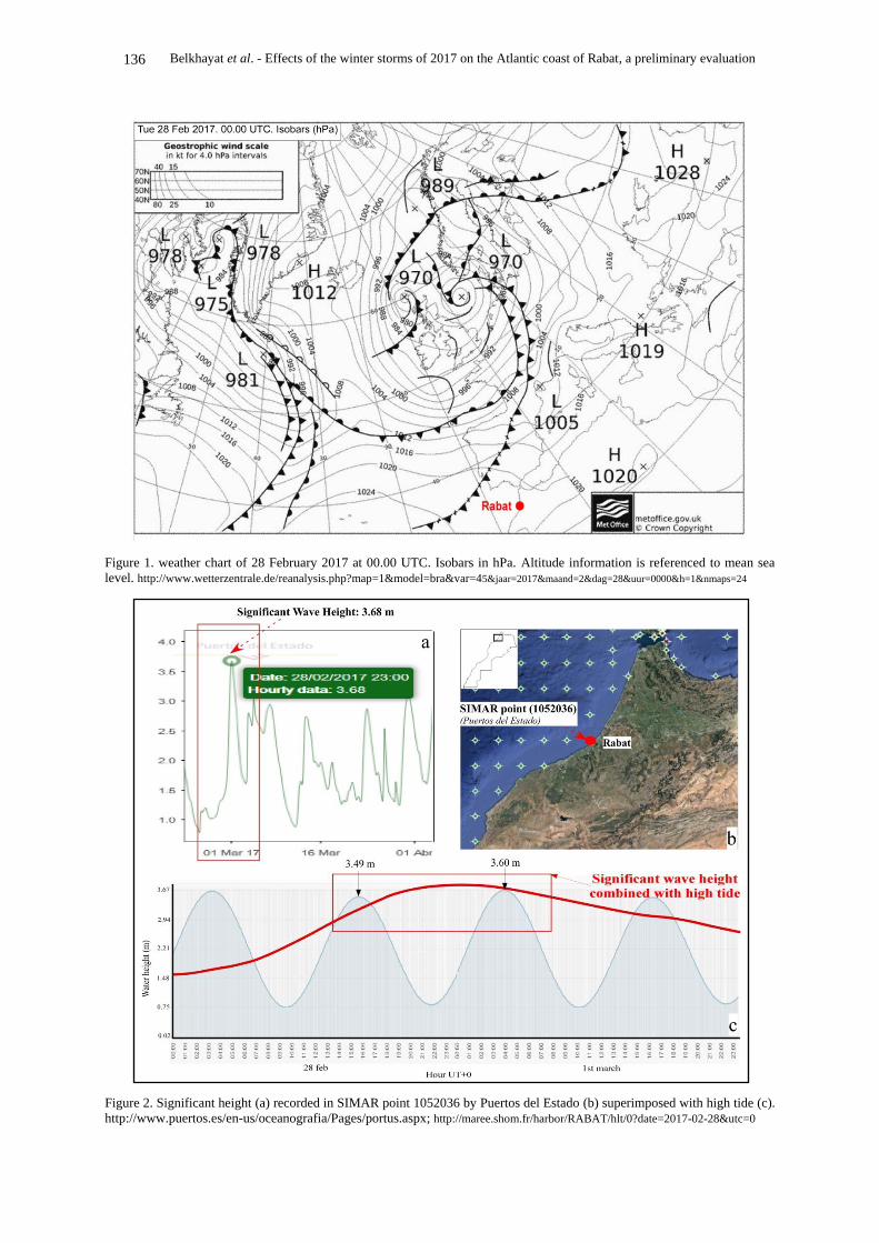
significant height recorded in SIMAR point 1052036
by Puertos del Estado (http://www.puertos.es/en-
us/oceanografia/Pages/portus.aspx) was about 3.68 m
136 Belkhayat et al. - Effects of the winter storms of 2017 on the Atlantic coast of Rabat, a preliminary evaluation
Figure 1. weather chart of 28 February 2017 at 00.00 UTC. Isobars in hPa. Altitude information is referenced to mean sea
level. http://www.wetterzentrale.de/reanalysis.php?map=1&model=bra&var=45&jaar=2017&maand=2&dag=28&uur=0000&h=1&nmaps=24
Figure 2. Significant height (a) recorded in SIMAR point 1052036 by Puertos del Estado (b) superimposed with high tide (c).
http://www.puertos.es/en-us/oceanografia/Pages/portus.aspx; http://maree.shom.fr/harbor/RABAT/hlt/0?date=2017-02-28&utc=0
Belkhayat et al. - Effects of the winter storms of 2017 on the Atlantic coast of Rabat, a preliminary evaluation 137
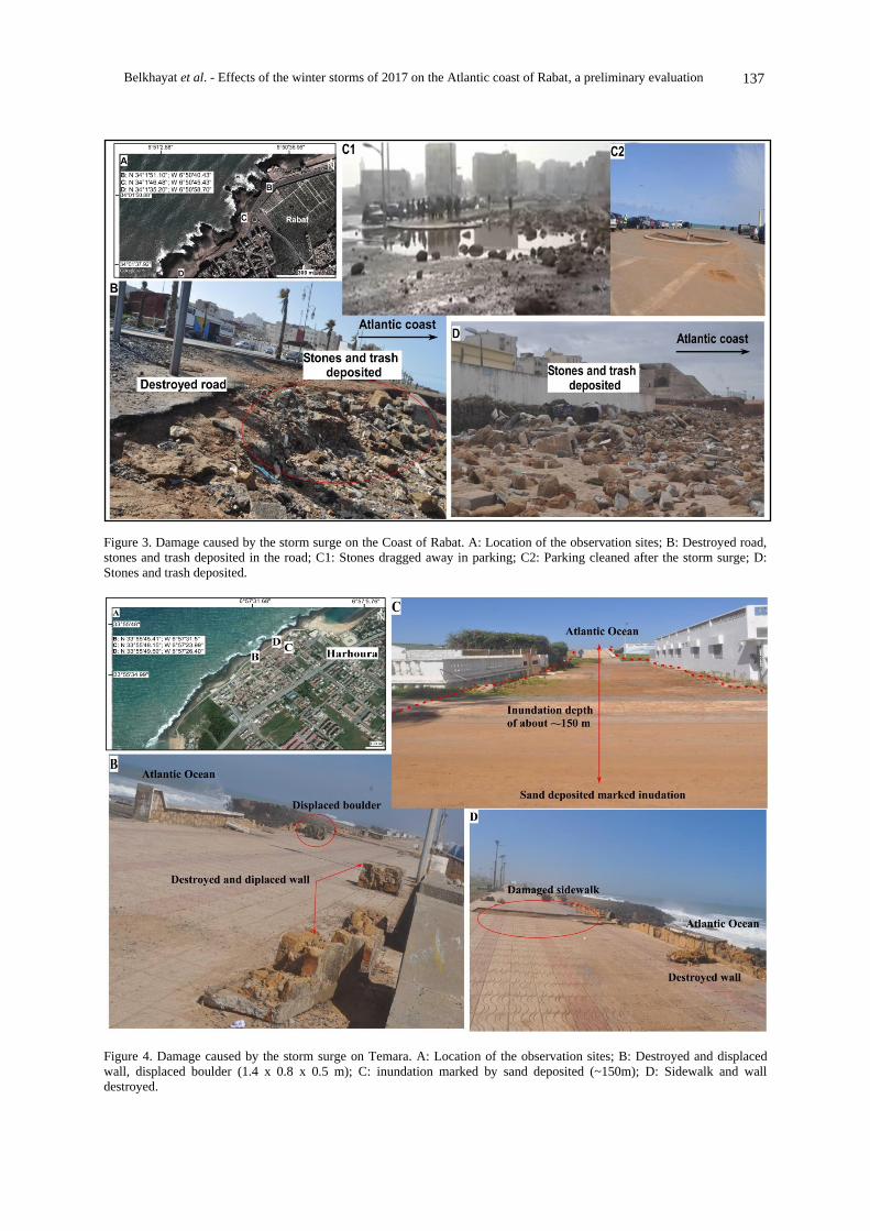
Figure 3. Damage caused by the storm surge on the Coast of Rabat. A: Location of the observation sites; B: Destroyed road,
stones and trash deposited in the road; C1: Stones dragged away in parking; C2: Parking cleaned after the storm surge; D:
Stones and trash deposited.
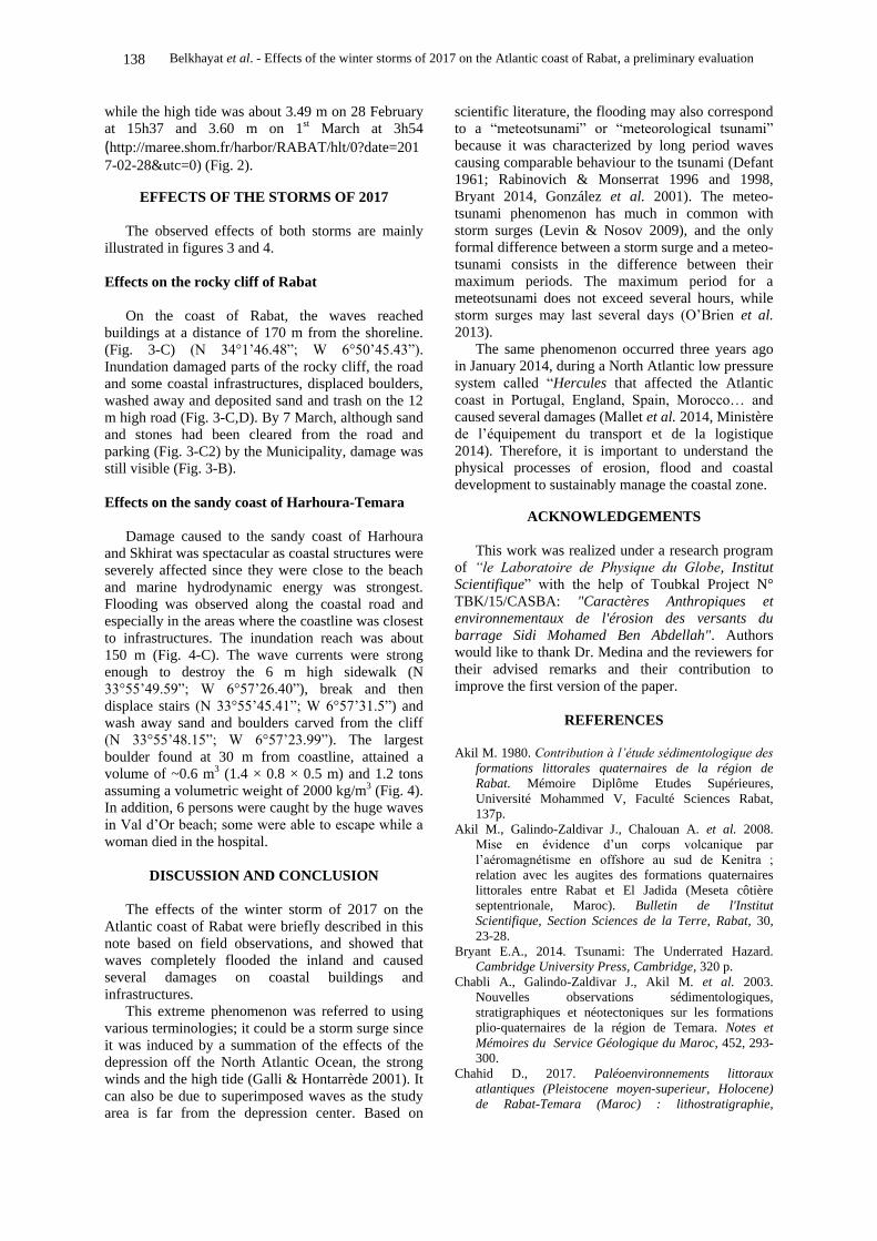
Figure 4. Damage caused by the storm surge on Temara. A: Location of the observation sites; B: Destroyed and displaced
wall, displaced boulder (1.4 x 0.8 x 0.5 m); C: inundation marked by sand deposited (~150m); D: Sidewalk and wall
destroyed.
138 Belkhayat et al. - Effects of the winter storms of 2017 on the Atlantic coast of Rabat, a preliminary evaluation
while the high tide was about 3.49 m on 28 February
at 15h37 and 3.60 m on 1st March at 3h54 (http://maree.shom.fr/harbor/RABAT/hlt/0?date=201
7-02-28&utc=0) (Fig. 2).
EFFECTS OF THE STORMS OF 2017
The observed effects of both storms are mainly
illustrated in figures 3 and 4.
Effects on the rocky cliff of Rabat
On the coast of Rabat, the waves reached
buildings at a distance of 170 m from the shoreline.
(Fig. 3-C) (N 34°1’46.48”; W 6°50’45.43”).
Inundation damaged parts of the rocky cliff, the road
and some coastal infrastructures, displaced boulders,
washed away and deposited sand and trash on the 12
m high road (Fig. 3-C,D). By 7 March, although sand
and stones had been cleared from the road and
parking (Fig. 3-C2) by the Municipality, damage was
still visible (Fig. 3-B).
Effects on the sandy coast of Harhoura-Temara
Damage caused to the sandy coast of Harhoura
and Skhirat was spectacular as coastal structures were
severely affected since they were close to the beach
and marine hydrodynamic energy was strongest.
Flooding was observed along the coastal road and
especially in the areas where the coastline was closest
to infrastructures. The inundation reach was about
150 m (Fig. 4-C). The wave currents were strong
enough to destroy the 6 m high sidewalk (N
33°55’49.59”; W 6°57’26.40”), break and then
displace stairs (N 33°55’45.41”; W 6°57’31.5”) and
wash away sand and boulders carved from the cliff
(N 33°55’48.15”; W 6°57’23.99”). The largest
boulder found at 30 m from coastline, attained a
volume of ~0.6 m3 (1.4 × 0.8 × 0.5 m) and 1.2 tons
assuming a volumetric weight of 2000 kg/m3 (Fig. 4).
In addition, 6 persons were caught by the huge waves
in Val d’Or beach; some were able to escape while a
woman died in the hospital.
DISCUSSION AND CONCLUSION
The effects of the winter storm of 2017 on the
Atlantic coast of Rabat were briefly described in this
note based on field observations, and showed that
waves completely flooded the inland and caused
several damages on coastal buildings and
infrastructures.
This extreme phenomenon was referred to using
various terminologies; it could be a storm surge since
it was induced by a summation of the effects of the
depression off the North Atlantic Ocean, the strong
winds and the high tide (Galli & Hontarrède 2001). It
can also be due to superimposed waves as the study
area is far from the depression center. Based on
scientific literature, the flooding may also correspond
to a “meteotsunami” or “meteorological tsunami”
because it was characterized by long period waves
causing comparable behaviour to the tsunami (Defant
1961; Rabinovich & Monserrat 1996 and 1998,
Bryant 2014, González et al. 2001). The meteo-
tsunami phenomenon has much in common with
storm surges (Levin & Nosov 2009), and the only
formal difference between a storm surge and a meteo-
tsunami consists in the difference between their
maximum periods. The maximum period for a
meteotsunami does not exceed several hours, while
storm surges may last several days (O’Brien et al.
2013).
The same phenomenon occurred three years ago
in January 2014, during a North Atlantic low pressure
system called “Hercules that affected the Atlantic
coast in Portugal, England, Spain, Morocco… and
caused several damages (Mallet et al. 2014, Ministère
de l’équipement du transport et de la logistique
2014). Therefore, it is important to understand the
physical processes of erosion, flood and coastal
development to sustainably manage the coastal zone.
ACKNOWLEDGEMENTS
This work was realized under a research program
of “le Laboratoire de Physique du Globe, Institut
Scientifique” with the help of Toubkal Project N°
TBK/15/CASBA: "Caractères Anthropiques et
environnementaux de l'érosion des versants du
barrage Sidi Mohamed Ben Abdellah". Authors
would like to thank Dr. Medina and the reviewers for
their advised remarks and their contribution to
improve the first version of the paper.
REFERENCES
Akil M. 1980. Contribution à l’étude sédimentologique des
formations littorales quaternaires de la région de
Rabat. Mémoire Diplôme Etudes Supérieures,
Université Mohammed V, Faculté Sciences Rabat,
137p.
Akil M., Galindo-Zaldivar J., Chalouan A. et al. 2008.
Mise en évidence d’un corps volcanique par
l’aéromagnétisme en offshore au sud de Kenitra ;
relation avec les augites des formations quaternaires
littorales entre Rabat et El Jadida (Meseta côtière
septentrionale, Maroc). Bulletin de l'Institut
Scientifique, Section Sciences de la Terre, Rabat, 30,
23-28.
Bryant E.A., 2014. Tsunami: The Underrated Hazard.
Cambridge University Press, Cambridge, 320 p.
Chabli A., Galindo-Zaldivar J., Akil M. et al. 2003.
Nouvelles observations sédimentologiques,
stratigraphiques et néotectoniques sur les formations
plio-quaternaires de la région de Temara. Notes et
Mémoires du Service Géologique du Maroc, 452, 293-
300.
Chahid D., 2017. Paléoenvironnements littoraux
atlantiques (Pleistocene moyen-superieur, Holocene)
de Rabat-Temara (Maroc) : lithostratigraphie,
Belkhayat et al. - Effects of the winter storms of 2017 on the Atlantic coast of Rabat, a preliminary evaluation 139
petrographie et geochronologie. Thèse de Doctorat,
Faculté des Sciences, Meknès, 249p.
Cherfaoui N. & Doghmi H. 2002. Vagues dans l’océan:
nouveau regard sur les digues portuaires : théorie et
exemples. Casablanca, sciences de l’ingénieur, Maroc.
435p.
Defant A. 1961. Physical Oceanography. Pergammon
Press, Oxford, 729p.
El Messaoudi B., Ait Laâmel M., El Hou M. & Bouksim,
H. 2016. Situations des fortes houles sur les côtes
atlantiques marocaines. Actes Session Plénière
Académie Hassan II des Sciences & Techniques, Rabat,
79-99.
Galli F.L., Hontarrede M. 2001. Surcote et marée de
tempête Revue de météorologie maritime de Météo-
France., 49, 79-89.
Gigout M. 1957. L’Ouljien dans le cadre du Tyrrhénien.
Bulletin de la Socité Géologique de France,7,4-5, 385-
400.
González J.I., Farreras S.F., Ochoa J. 2001. Seismic and
meteorological tsunami contributions in the Manzanillo
and Cabo San Lucas seiches of September 14, 1995.
Marine Geodesy 24, 219-227.
Levin B. and Nosov M. 2009. Physics of Tsunamis, chap.
4: The Physics of Tsunami Formation by Sources of
Nonseismic Origin Springer, 388p.
Mallet C., Garnier C., Maugard F. et al. 2014. Compte-
rendu des observations post-tempêtes sur le littoral
aquitain (décembre 2013 –janvier 2014). Rapport final.
BRGM/RP-63182-FR, 81p, 109fig.
Ministère de l’équipement du transport et de la logistique
2014. Impacts de la houle exceptionnelle du 06-07
janvier 2014 sur les infrastructures portuaires. Rapport
inédit, 33p.
Minoubi A., El Khalidi K., Chaibi M. et al. 2013. Variation
morphosédimentaire saisonnière et impact de la
tempête de Janvier 2009 sur la côte de Safi, Maroc.
ScienceLib Editions Mersenne, 5, 130202.
O’Brien L., Dudley J .M. & Dias F. 2013. Extreme wave
events in Ireland: 14680 BP-2012. Natural Hazards
Earth System. Sciences, 13, 625-648.
Rabinovich A.B., Monserrat S., 1996. Meteorological
tsunami near the Balearic and Kuril Islands: descriptive
and statistical analysis. Natural Hazards 13, 55-90.
Rabinovich A.B., Monserrat S. 1998. Generation of
meteorological tsunami (large amplitude seiches) near
the Balearic and Kuril Islands. Natural Hazards 18, 27-
55.
Saaidi E. 1988. Géologie du Quaternaire marocain. Ed
SMER, Rabat, 440p.
Simonet R, Tanguy R. 1962. Etude statistique de la houle
dans les différents ports marocains pour la période
1928–1952. Annales du Service de la Physique du
Globe et de la Météorologie, Rabat, XVI, 109-130.
Manuscrit reçu le 30/05/2017
Version révisée acceptée le 29/12/2017
Version finale reçue le 30/12/2017
Mise en ligne le 31/12/2017