Embed Size (px)
Citation preview
Lachine Canal National Historic Site of Canada
Management Plan
2018
ii
© Her Majesty the Queen in Right of Canada, represented by the Chief Executive Officer of Parks Canada, 2018. Parks Canada
LACHINE CANAL NATIONAL HISTORIC SITE OF CANADA MANAGEMENT PLAN, 2018. Paper: R64-501/2018E 978-0-660-09402-1 PDF: R64-501/2018E-PDF 978-0-660-09401-4 Cette publication est aussi disponible en français. For more information about the management plan or about LACHINE CANAL NATIONAL HISTORIC SITE OF CANADA:
Lachine Canal National Historic Site of Canada 105 McGill Street, 6th Floor Montreal (Quebec)
H2Y 2E7
Tel.: 514-283-6054 fax: 514-496-1263
E-mail: [email protected] https://www.pc.gc.ca/en/lhn-nhs/qc/canallachine/info/gestion-management
Front cover image credits
Top from left to right: Parks Canada and National Archives of Canada/PA-183232
Bottom: Parks Canada
Lachine Canal National Historic Site vii Management plan
Executive Summary
The Lachine Canal National Historic Site of Canada is located in the southern part of the island of Montreal. This 14.5 kilometre long engineering structure was built between 1821 and 1825 in order to bypass the Lachine Rapids. It not only facilitated the transport of merchandise, but it also contributed significantly to the economic and urban development of the Montreal area. It is also recognized as the founding site of the manufacturing industry in the country. The canal was designated of national historic significance in 1929. Today, the Lachine Canal continues to welcome recreational boaters and offer lockage and mooring services, while its banks and multifunctional path attract over 1.2 million strollers and cyclists annually. The remaining industrial relics as well as its unique character are also valued by heritage enthusiasts. This management plan replaces the 2004 management plan, which coincided with the reopening of the canal after being non-functional for over 30 years. A number of the objectives of the 2004 plan were achieved and were successful in terms of development, partnership and transformation of the site. Major investments announced in 2015 resulted in the current rehabilitation works of the canal infrastructure and will guarantee the maintenance of the infrastructure essential to its operation. The new management plan is therefore part of the renewal of the site and its surroundings, in the midst of a full urban redevelopment process. The plan will also allow the canal to better position itself within Montreal’s tourist and cultural activities. The vision for the Lachine Canal aims to create an emblematic and inspiring place, supported by a community committed to its protection and improvement. To achieve this vision, four key strategies will guide the management of the site over the next 10 years: Strategy 1: The Lachine Canal: a Montreal emblem!
This strategy is intended to create a strong identity for the canal and to provide a distinctive signature that is rooted in the heritage values of the site, making it a major destination for local visitors and tourists. Three objectives support this strategy: Objective 1.1: The redevelopment of the Lachine Canal is distinctive by its urban
approach and emphasizes the participation of innovative and creative stakeholders of the Montreal community.
Objective 1.2: The condition and integrity of cultural resources associated with the canal's engineering works and buildings are improved.
Objective 1.3: Dialogue with the urban planning departments of the City of Montreal boroughs is maintained and improved, in order to reinforce the uniqueness of the Lachine Canal's urban cultural landscape.
Strategy 2: A renewed visitor experience This second strategy as well as the objectives below focus on the renewal of the facilities and services offered, in order to better reflect the expectations of a variety of different users as well as the recent transformations of adjacent neighbourhoods.
viii
Objective 2.1: Visitor experience is enhanced and the full development potential of the canal is achieved.
Objective 2.2: A Master Plan is devised and innovative experiences are offered to visitors for each of the canal’s sectors, reflecting their history and unique features.
Objective 2.3: Cyclists and strollers appreciate a variety of experiences and paths available, either on the canal banks, in adjacent neighborhoods or in other Parks Canada sites that welcome cyclists.
Objective 2.4: Public docks and services for recreational boaters are added. Objective 2.5: In collaboration with its partners, the canal offers a program of
activities spread out over the four seasons. Strategy 3: An important collective asset, a development force for communities The third strategy seeks to increase integration of the canal with adjacent communities to foster their ownership and to create positive impacts. Its objectives are: Objective 3.1: The communities rally for the canal and actively contribute to its
activities and its outreach through the establishment of a new partnership approach. Objective 3.2: Increasing canal visitation translates into socio-economic and
community development opportunities for stakeholders in adjacent communities. Strategy 4: An exceptional showcase for history and innovation This strategy seeks to take advantage of the canal's urban setting to promote the unique expertise of Parks Canada and its vast network of protected areas. Objective 4.1: The Lachine Canal is a privileged site within Parks Canada for
promoting its mission and historic sites, national parks and marine conservation areas managed by the Agency.
Objective 4.2: In collaboration with the national outreach/cultural program, the Lachine Canal is actively involved in increasing awareness of historic sites, national parks and marine conservation areas.
This management plan advocates a more targeted management approach for the Peel Basin sector. Historically, the Peel Basin was a strategic point of convergence for ships navigating the canal. Today, it lies at the gateway to the Old Port and downtown Montreal and has a largely unexploited potential. The following is proposed for the Peel Basin management area: • Community partners collaborate with Parks Canada to develop a collective
development vision for the Peel Basin area and commit to integrate it into their respective projects to strengthen the unique identity of the site.
• The Peel Basin is a veritable gateway to the canal and its connections with the surrounding communities are maximized.
• The uniqueness of the Peel Basin is celebrated through innovative activities and experiences that combine both water and heritage symbols of the site and the surrounding areas.
Lachine Canal National Historic Site ix Management plan
Table of contents
Foreword ........................................................................................................................... iii
Recommandations ......................................................................................................... v
Executive Summary ..................................................................................................... vii
1.0 Introduction .............................................................................................................. 1
2.0 Significance of Lachine Canal National Historic Site ......................... 17
3.0 Planning Context ................................................................................................. 17
4.0 Vision ......................................................................................................................... 18
5.0 Key Strategies ....................................................................................................... 19
6.0 Area Management Approach for the Peel Basin ................................ 23
7.0 Summary of Strategic Environmental Assessment ............................. 28
Maps
Map 1 : Regional context .......................................................................................... 3
Map 2 : Lachine Canal National Historic Site .................................................. 5
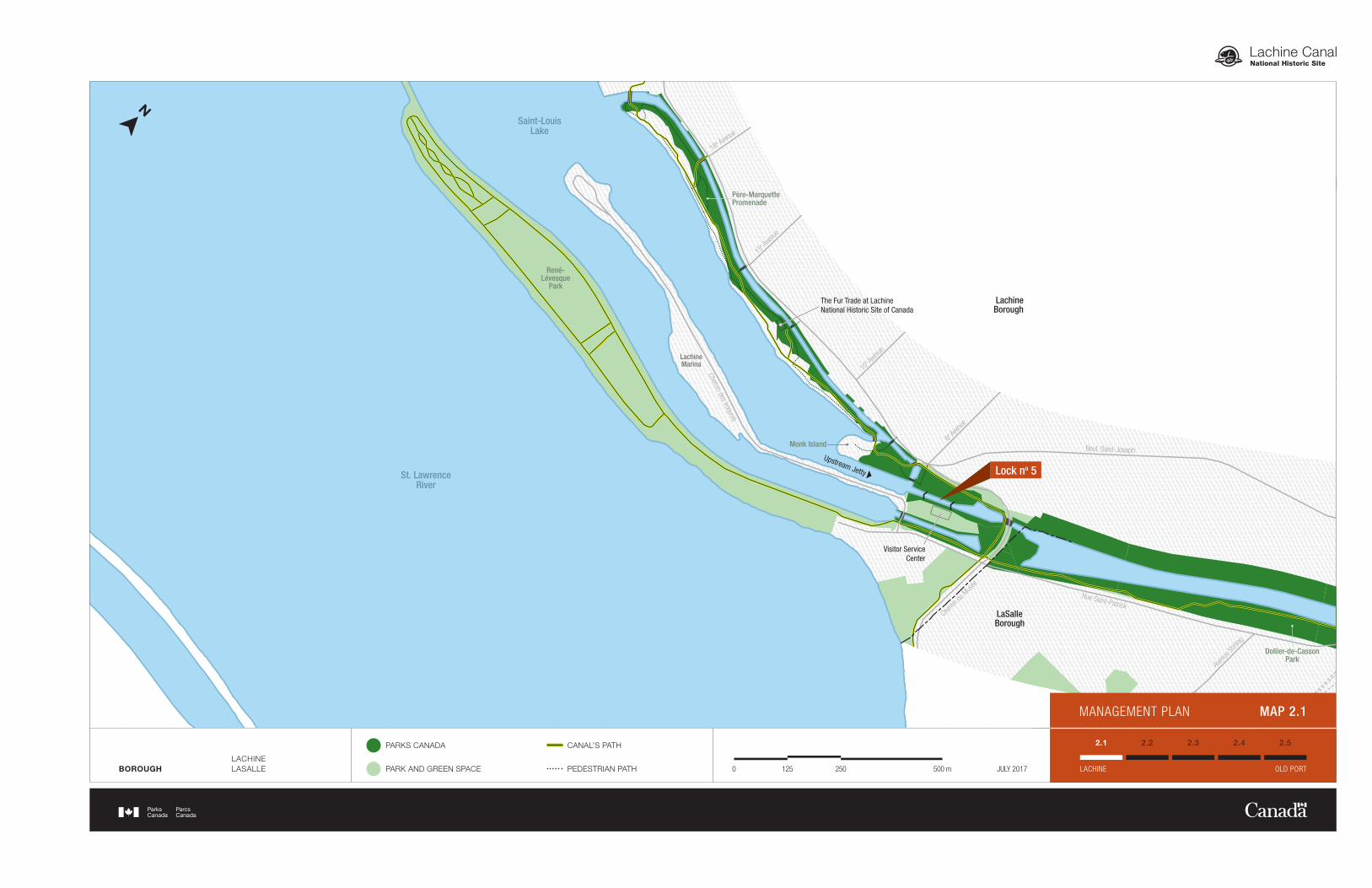
Map 2.1 ............................................................................................................................... 7
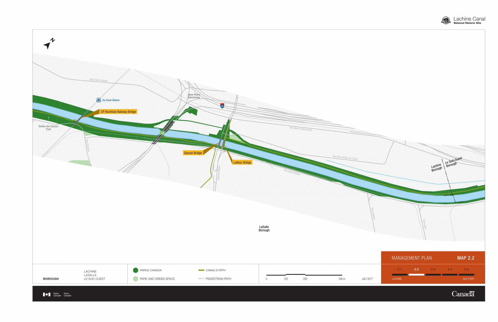
Map 2.2 ............................................................................................................................... 9
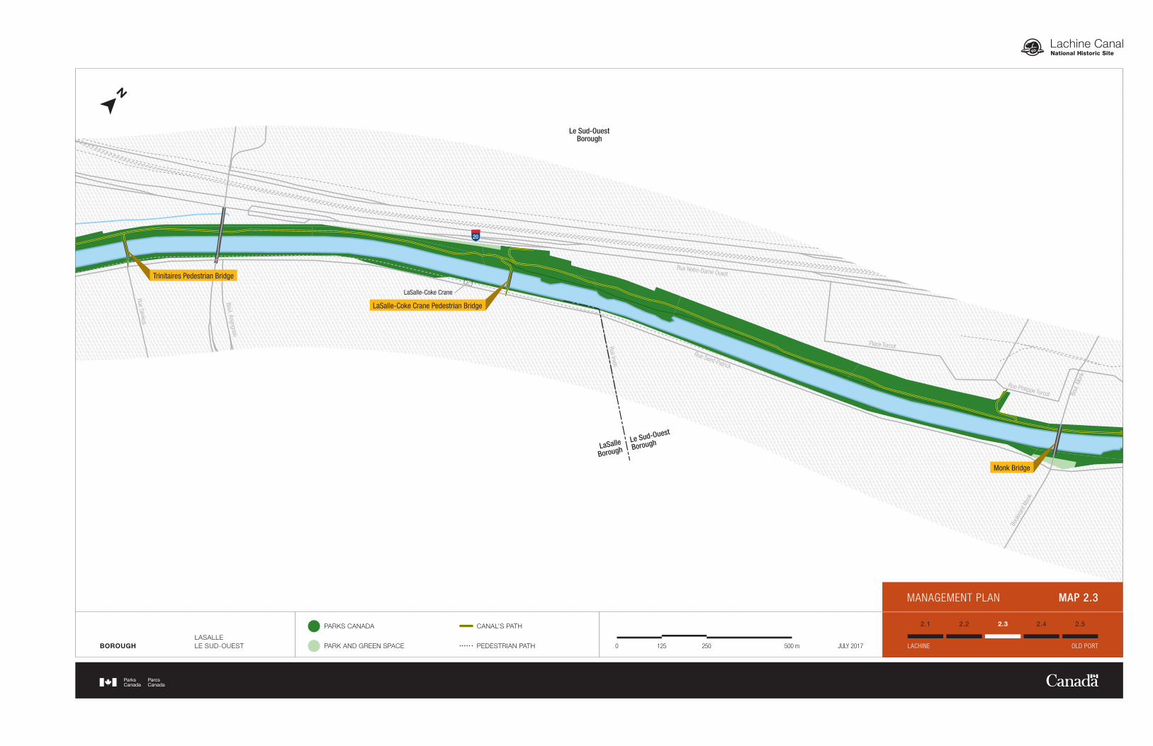
Map 2.3 ............................................................................................................................ 11
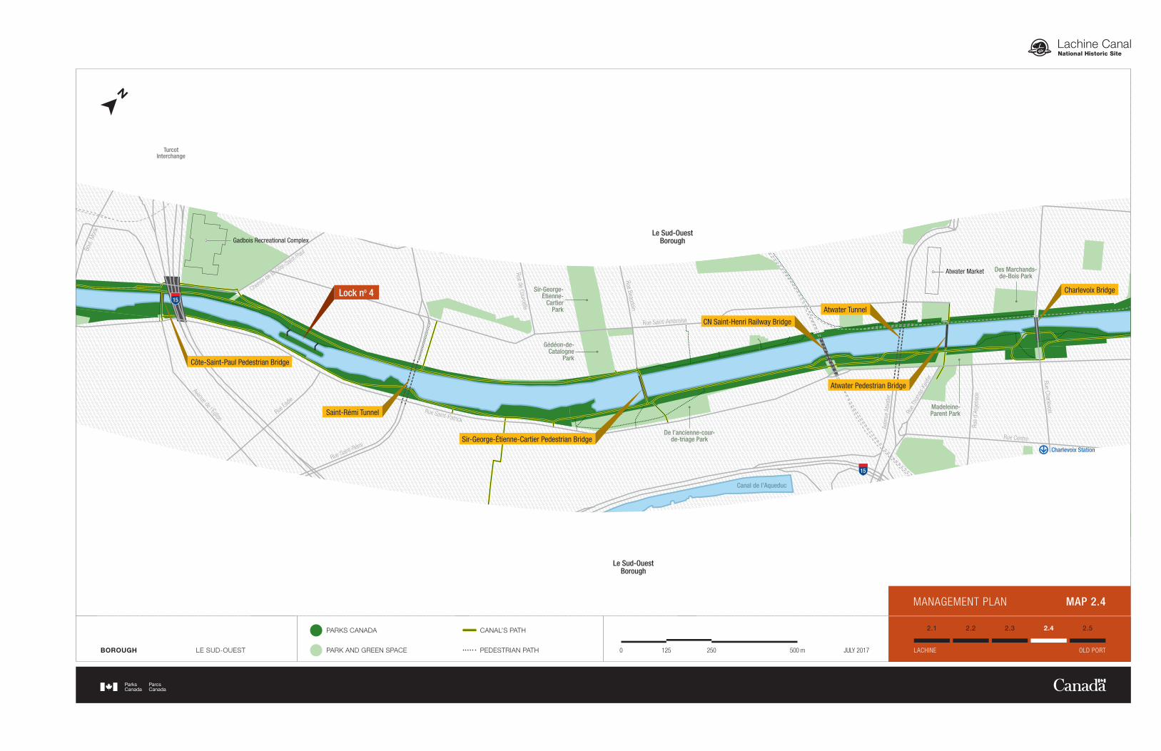
Map 2.4 ............................................................................................................................ 13
Map 2.5 ............................................................................................................................ 15
Map 3 : Peel Basin Management Area ............................................................ 25
Lachine Canal National Historic Site 1 Management plan
1.0 Introduction Parks Canada manages one of the finest and most extensive systems of protected natural and historic places in the world. The Agency’s mandate is to protect and present these places for the benefit and enjoyment of current and future generations. Future-oriented, strategic management of each national park, national marine conservation area, heritage canal and those national historic sites administered by Parks Canada supports the Agency’s vision: Canada’s treasured natural and historic places will be a living legacy, connecting hearts and minds to a stronger, deeper understanding of the very essence of Canada. The Parks Canada Agency Act requires Parks Canada to prepare a management plan for national historic sites administered by the Agency. The Lachine Canal National Historic Site of Canada Management Plan, once approved by the Minister responsible for Parks Canada and tabled in Parliament, ensures Parks Canada’s accountability to Canadians, outlining how historic site management will achieve measurable results in support of the Agency’s mandate. Canadians, local partners and many stakeholders were involved in the preparation of the management plan, helping to shape the future direction of the national historic site. The plan sets clear, strategic direction for the management and operation of Lachine Canal National Historic Site by articulating a vision, key strategies and objectives. Parks Canada will report annually on progress toward achieving the plan objectives and will review the plan every ten years or sooner if required. This plan is not an end in and of itself. Parks Canada will maintain an open dialogue on the implementation of the management plan, to ensure that it remains relevant and meaningful. The plan will serve as the focus for ongoing engagement on the management of Lachine Canal National Historic Site in years to come.
40
20
15
10
30
20
40
25
15
15
30
MONTRÉAL
LAVAL
LONGUEUILÎLE-PERROT
VAUDREUIL-DORION
CHAMBLY
SAINT-OURS
SAINT-JEAN-SUR-RICHELIEU
ONTARIO
QUÉBEC
ESTRIE
(UNITED STATES)
Sainte-Anne-de-Bellevue Canal
Carillon Canal
Saint-Ours Canal
Chambly Canal
Lachine Canal
REGION QUÉBEC WATERWAYS PARKS CANADA’S HISTORIC CANALS (QUÉBEC) 1050 20 km JULY 2017REGIONAL CONTEXT MAP 1
Le Sud-OuestBorough
Le Sud-OuestBorough
Le Sud-OuestBorough
Le Sud-OuestBorough
LaSalleBorough
LaSalleBorough
LachineBorough
LaSalleBorough
LachineBorough
Ville-MarieBorough
Le Sud-OuestBorough
René-LévesquePark
Saint-PierreInterchange
GadboisRecreational Complex
LaSalle-CokeCrane
AtwaterMarket
PeelBasin
10
15
20
20
MAP 2.1
MAP 2.2
MAP 2.3
MAP 2.4 MAP 2.5
PEEL BASIN MANAGEMENT AREA
PARKS CANADA
PARK AND GREEN SPACE 10.50 2 km JULY 2017MANAGEMENT PLAN MAP 2
Ville-Marie
BoroughLe Sud-Ouest
Borough
Le Sud-OuestBorough
Le Sud-OuestBorough
Le Sud-OuestBorough
Le Sud-Ouest
Borough
Le Sud-Ouest
BoroughLaSalle
Borough
LaSalleBorough
LaSalleBorough
LachineBorough
Lachine
Borough
Rue William
Rue Notre-Dame O
Rue Mill
Auto
rout
e Bo
nave
ntur
e
Rue de
la Com
mune O
Rue Wellington
Rue Peel
Rue McGill
Rue Ottawa
Rue Basin
Rue de la Montagne
Rue des Seigneurs
Rue Bridge
Rue Saint-Patrick
Rue du Canal
Rue Charlevoix
Rue Centre
Rue
d’Ar
gens
on
Rue
Isla
nd
Rue
de M
ontm
oren
cy
Aven
ue A
twat
er
Rue Saint-Ambroise
Rue de Courcelle
Rue Beaudoin
Chemin de la
Côte-Sain
t-Paul
Rue T
hom
as-K
eefe
r
Rue Saint-Patrick
Rue Saint-Rémi
Rue Ea
die
Avenue de l’Église
Rue Saint-Patrick
Rue Irwin
Rue Senkus
Boul. Angrignon
Rue Notre-Dame Ouest
Boule
vard
Mon
k
Boul
. Mon
k
Rue Philippe Turcot
Place Turcot
Rue Saint-Patrick
Rue Lapierre Rue Léger
Aven
ue D
olla
rd
Rue Clément
Boul. Saint-Joseph
Boul. Saint-Joseph
10e Av
enue
15e Av
enue
6e Av
enue
18e Avenue
Chemin des Iroquois
Rue Notre-Dame Ouest
Rue de la Berge-du-Canal
Rue Saint-Patrick
Aven
ue St
irling
Chemin
du M
usée
PeelBasin
Lock no 3
Lock no 4
Lock no 1
Mill BridgeWellington BridgeCharlevoix Bridge
Des Seigneurs Bridge Hall Pedestrian Bridge
Atwater Pedestrian Bridge
Atwater Tunnel
CN Saint-Henri Railway Bridge
Saint-Rémi Tunnel
Côte-Saint-Paul Pedestrian Bridge
Sir-George-Étienne-Cartier Pedestrian Bridge
CN Wellington Railway Bridge
CN du Port Bridge
Wellington Pedestrian Bridge
Lock no 2
Saint-PatrickSquare
SmithPromenade
Pointe des Seigneurs Archaelogical Site
Des éclusiersPark
Des Marchands-de-Bois Park
Gédéon-de-Catalogne
Park
De l’ancienne-cour-de-triage Park
Sir-George-Étienne-
CartierPark
Madeleine-Parent Park
Bassin-à-GravierPark
Grain Elevator no 5
Lockmasters House
Flour Docks
Lachine Canal Workshop
10
Consumers Cordage Co.
Atwater Market
Gadbois Recreational Complex
15
Monk Bridge
LaSalle-Coke Crane
15
LaSalle-Coke Crane Pedestrian Bridge
Trinitaires Pedestrian Bridge
Lafleur Bridge
Gauron Bridge
20
20
138
CP Rockfield Railway Bridge
Dollier-de-CassonPark
Saint-LouisLake
St. LawrenceRiver
René-Lévesque
Park
Monk Island
Lock no 5
Visitor ServiceCenter
The Fur Trade at LachineNational Historic Site of Canada
Père-MarquettePromenade
Downs
tream
Jetty
Upstream Jetty
Charlevoix Station
Canal de l’Aqueduc
LachineMarina
Du Canal Station
Saint-PierreInterchange
TurcotInterchange
Peel Basin Management Area
MANAGEMENT PLAN MAP 2.1
BOROUGHLACHINELASALLE
PARKS CANADA
PARK AND GREEN SPACE
CANAL’S PATH
PEDESTRIAN PATH 2501250 500 m JULY 2017
2.2 2.3 2.4 2.5
LACHINE OLD PORT
2.1
Ville-Marie
BoroughLe Sud-Ouest
Borough
Le Sud-OuestBorough
Le Sud-OuestBorough
Le Sud-OuestBorough
Le Sud-Ouest
Borough
Le Sud-Ouest
BoroughLaSalle
Borough
LaSalleBorough
LaSalleBorough
LachineBorough
Lachine
Borough
Rue William
Rue Notre-Dame O
Rue Mill
Auto
rout
e Bo
nave
ntur
e
Rue de
la Com
mune O
Rue Wellington
Rue Peel
Rue McGill
Rue Ottawa
Rue Basin
Rue de la Montagne
Rue des Seigneurs
Rue Bridge
Rue Saint-Patrick
Rue du Canal
Rue Charlevoix
Rue Centre
Rue
d’Ar
gens
on
Rue
Isla
nd
Rue
de M
ontm
oren
cy
Aven
ue A
twat
er
Rue Saint-Ambroise
Rue de Courcelle
Rue Beaudoin
Chemin de la
Côte-Sain
t-Paul
Rue T
hom
as-K
eefe
r
Rue Saint-Patrick
Rue Saint-Rémi
Rue Ea
die
Avenue de l’Église
Rue Saint-Patrick
Rue Irwin
Rue Senkus
Boul. Angrignon
Rue Notre-Dame Ouest
Boule
vard
Mon
k
Boul
. Mon
k
Rue Philippe Turcot
Place Turcot
Rue Saint-Patrick
Rue Lapierre Rue Léger
Aven
ue D
olla
rd
Rue Clément
Boul. Saint-Joseph
Boul. Saint-Joseph
10e Av
enue
15e Av
enue
6e Av
enue
18e Avenue
Chemin des Iroquois
Rue Notre-Dame Ouest
Rue de la Berge-du-Canal
Rue Saint-Patrick
Aven
ue St
irling
Chemin
du M
usée
PeelBasin
Lock no 3
Lock no 4
Lock no 1
Mill BridgeWellington BridgeCharlevoix Bridge
Des Seigneurs Bridge Hall Pedestrian Bridge
Atwater Pedestrian Bridge
Atwater Tunnel
CN Saint-Henri Railway Bridge
Saint-Rémi Tunnel
Côte-Saint-Paul Pedestrian Bridge
Sir-George-Étienne-Cartier Pedestrian Bridge
CN Wellington Railway Bridge
CN du Port Bridge
Wellington Pedestrian Bridge
Lock no 2
Saint-PatrickSquare
SmithPromenade
Pointe des Seigneurs Archaelogical Site
Des éclusiersPark
Des Marchands-de-Bois Park
Gédéon-de-Catalogne
Park
De l’ancienne-cour-de-triage Park
Sir-George-Étienne-
CartierPark
Madeleine-Parent Park
Bassin-à-GravierPark
Grain Elevator no 5
Lockmasters House
Flour Docks
Lachine Canal Workshop
10
Consumers Cordage Co.
Atwater Market
Gadbois Recreational Complex
15
Monk Bridge
LaSalle-Coke Crane
15
LaSalle-Coke Crane Pedestrian Bridge
Trinitaires Pedestrian Bridge
Lafleur Bridge
Gauron Bridge
20
20
138
CP Rockfield Railway Bridge
Dollier-de-CassonPark
Saint-LouisLake
St. LawrenceRiver
René-Lévesque
Park
Monk Island
Lock no 5
Visitor ServiceCenter
The Fur Trade at LachineNational Historic Site of Canada
Père-MarquettePromenade
Downs
tream
Jetty
Upstream Jetty
Charlevoix Station
Canal de l’Aqueduc
LachineMarina
Du Canal Station
Saint-PierreInterchange
TurcotInterchange
Peel Basin Management Area
BOROUGH
LACHINELASALLELE SUD-OUEST
PARKS CANADA
PARK AND GREEN SPACE
CANAL’S PATH
PEDESTRIAN PATH 2501250 500 m JULY 2017
2.2 2.3 2.4 2.5
LACHINE OLD PORT
2.1
MANAGEMENT PLAN MAP 2.2
Ville-Marie
BoroughLe Sud-Ouest
Borough
Le Sud-OuestBorough
Le Sud-OuestBorough
Le Sud-OuestBorough
Le Sud-Ouest
Borough
Le Sud-Ouest
BoroughLaSalle
Borough
LaSalleBorough
LaSalleBorough
LachineBorough
Lachine
Borough
Rue William
Rue Notre-Dame O
Rue Mill
Auto
rout
e Bo
nave
ntur
e
Rue de
la Com
mune O
Rue Wellington
Rue Peel
Rue McGill
Rue Ottawa
Rue Basin
Rue de la Montagne
Rue des Seigneurs
Rue Bridge
Rue Saint-Patrick
Rue du Canal
Rue Charlevoix
Rue Centre
Rue
d’Ar
gens
on
Rue
Isla
nd
Rue
de M
ontm
oren
cy
Aven
ue A
twat
er
Rue Saint-Ambroise
Rue de Courcelle
Rue Beaudoin
Chemin de la
Côte-Sain
t-Paul
Rue T
hom
as-K
eefe
r
Rue Saint-Patrick
Rue Saint-Rémi
Rue Ea
die
Avenue de l’Église
Rue Saint-Patrick
Rue Irwin
Rue Senkus
Boul. Angrignon
Rue Notre-Dame Ouest
Boule
vard
Mon
k
Boul
. Mon
k
Rue Philippe Turcot
Place Turcot
Rue Saint-Patrick
Rue Lapierre Rue Léger
Aven
ue D
olla
rd
Rue Clément
Boul. Saint-Joseph
Boul. Saint-Joseph
10e Av
enue
15e Av
enue
6e Av
enue
18e Avenue
Chemin des Iroquois
Rue Notre-Dame Ouest
Rue de la Berge-du-Canal
Rue Saint-Patrick
Aven
ue St
irling
Chemin
du M
usée
PeelBasin
Lock no 3
Lock no 4
Lock no 1
Mill BridgeWellington BridgeCharlevoix Bridge
Des Seigneurs Bridge Hall Pedestrian Bridge
Atwater Pedestrian Bridge
Atwater Tunnel
CN Saint-Henri Railway Bridge
Saint-Rémi Tunnel
Côte-Saint-Paul Pedestrian Bridge
Sir-George-Étienne-Cartier Pedestrian Bridge
CN Wellington Railway Bridge
CN du Port Bridge
Wellington Pedestrian Bridge
Lock no 2
Saint-PatrickSquare
SmithPromenade
Pointe des Seigneurs Archaelogical Site
Des éclusiersPark
Des Marchands-de-Bois Park
Gédéon-de-Catalogne
Park
De l’ancienne-cour-de-triage Park
Sir-George-Étienne-
CartierPark
Madeleine-Parent Park
Bassin-à-GravierPark
Grain Elevator no 5
Lockmasters House
Flour Docks
Lachine Canal Workshop
10
Consumers Cordage Co.
Atwater Market
Gadbois Recreational Complex
15
Monk Bridge
LaSalle-Coke Crane
15
LaSalle-Coke Crane Pedestrian Bridge
Trinitaires Pedestrian Bridge
Lafleur Bridge
Gauron Bridge
20
20
138
CP Rockfield Railway Bridge
Dollier-de-CassonPark
Saint-LouisLake
St. LawrenceRiver
René-Lévesque
Park
Monk Island
Lock no 5
Visitor ServiceCenter
The Fur Trade at LachineNational Historic Site of Canada
Père-MarquettePromenade
Downs
tream
Jetty
Upstream Jetty
Charlevoix Station
Canal de l’Aqueduc
LachineMarina
Du Canal Station
Saint-PierreInterchange
TurcotInterchange
Peel Basin Management Area
BOROUGHLASALLELE SUD-OUEST
PARKS CANADA
PARK AND GREEN SPACE
CANAL’S PATH
PEDESTRIAN PATH 2501250 500 m JULY 2017
2.2 2.3 2.4 2.5
LACHINE OLD PORT
2.1
MANAGEMENT PLAN MAP 2.3
Ville-Marie
BoroughLe Sud-Ouest
Borough
Le Sud-OuestBorough
Le Sud-OuestBorough
Le Sud-OuestBorough
Le Sud-Ouest
Borough
Le Sud-Ouest
BoroughLaSalle
Borough
LaSalleBorough
LaSalleBorough
LachineBorough
Lachine
Borough
Rue William
Rue Notre-Dame O
Rue Mill
Auto
rout
e Bo
nave
ntur
e
Rue de
la Com
mune O
Rue Wellington
Rue Peel
Rue McGill
Rue Ottawa
Rue Basin
Rue de la Montagne
Rue des Seigneurs
Rue Bridge
Rue Saint-Patrick
Rue du Canal
Rue Charlevoix
Rue Centre
Rue
d’Ar
gens
on
Rue
Isla
nd
Rue
de M
ontm
oren
cy
Aven
ue A
twat
er
Rue Saint-Ambroise
Rue de Courcelle
Rue Beaudoin
Chemin de la
Côte-Sain
t-Paul
Rue T
hom
as-K
eefe
r
Rue Saint-Patrick
Rue Saint-Rémi
Rue Ea
die
Avenue de l’Église
Rue Saint-Patrick
Rue Irwin
Rue Senkus
Boul. Angrignon
Rue Notre-Dame Ouest
Boule
vard
Mon
k
Boul
. Mon
k
Rue Philippe Turcot
Place Turcot
Rue Saint-Patrick
Rue Lapierre Rue Léger
Aven
ue D
olla
rd
Rue Clément
Boul. Saint-Joseph
Boul. Saint-Joseph
10e Av
enue
15e Av
enue
6e Av
enue
18e Avenue
Chemin des Iroquois
Rue Notre-Dame Ouest
Rue de la Berge-du-Canal
Rue Saint-Patrick
Aven
ue St
irling
Chemin
du M
usée
PeelBasin
Lock no 3
Lock no 4
Lock no 1
Mill BridgeWellington BridgeCharlevoix Bridge
Des Seigneurs Bridge Hall Pedestrian Bridge
Atwater Pedestrian Bridge
Atwater Tunnel
CN Saint-Henri Railway Bridge
Saint-Rémi Tunnel
Côte-Saint-Paul Pedestrian Bridge
Sir-George-Étienne-Cartier Pedestrian Bridge
CN Wellington Railway Bridge
CN du Port Bridge
Wellington Pedestrian Bridge
Lock no 2
Saint-PatrickSquare
SmithPromenade
Pointe des Seigneurs Archaelogical Site
Des éclusiersPark
Des Marchands-de-Bois Park
Gédéon-de-Catalogne
Park
De l’ancienne-cour-de-triage Park
Sir-George-Étienne-
CartierPark
Madeleine-Parent Park
Bassin-à-GravierPark
Grain Elevator no 5
Lockmasters House
Flour Docks
Lachine Canal Workshop
10
Consumers Cordage Co.
Atwater Market
Gadbois Recreational Complex
15
Monk Bridge
LaSalle-Coke Crane
15
LaSalle-Coke Crane Pedestrian Bridge
Trinitaires Pedestrian Bridge
Lafleur Bridge
Gauron Bridge
20
20
138
CP Rockfield Railway Bridge
Dollier-de-CassonPark
Saint-LouisLake
St. LawrenceRiver
René-Lévesque
Park
Monk Island
Lock no 5
Visitor ServiceCenter
The Fur Trade at LachineNational Historic Site of Canada
Père-MarquettePromenade
Downs
tream
Jetty
Upstream Jetty
Charlevoix Station
Canal de l’Aqueduc
LachineMarina
Du Canal Station
Saint-PierreInterchange
TurcotInterchange
Peel Basin Management Area
BOROUGH LE SUD-OUEST
PARKS CANADA
PARK AND GREEN SPACE
CANAL’S PATH
PEDESTRIAN PATH 2501250 500 m JULY 2017
2.2 2.3 2.4 2.5
LACHINE OLD PORT
2.1
MANAGEMENT PLAN MAP 2.4
Ville-Marie
BoroughLe Sud-Ouest
Borough
Le Sud-OuestBorough
Le Sud-OuestBorough
Le Sud-OuestBorough
Le Sud-Ouest
Borough
Le Sud-Ouest
BoroughLaSalle
Borough
LaSalleBorough
LaSalleBorough
LachineBorough
Lachine
Borough
Rue William
Rue Notre-Dame O
Rue Mill
Auto
rout
e Bo
nave
ntur
e
Rue de
la Com
mune O
Rue Wellington
Rue Peel
Rue McGill
Rue Ottawa
Rue Basin
Rue de la Montagne
Rue des Seigneurs
Rue Bridge
Rue Saint-Patrick
Rue du Canal
Rue Charlevoix
Rue Centre
Rue
d’Ar
gens
on
Rue
Isla
nd
Rue
de M
ontm
oren
cy
Aven
ue A
twat
er
Rue Saint-Ambroise
Rue de Courcelle
Rue Beaudoin
Chemin de la
Côte-Sain
t-Paul
Rue T
hom
as-K
eefe
r
Rue Saint-Patrick
Rue Saint-Rémi
Rue Ea
die
Avenue de l’Église
Rue Saint-Patrick
Rue Irwin
Rue Senkus
Boul. Angrignon
Rue Notre-Dame Ouest
Boule
vard
Mon
k
Boul
. Mon
k
Rue Philippe Turcot
Place Turcot
Rue Saint-Patrick
Rue Lapierre Rue Léger
Aven
ue D
olla
rd
Rue Clément
Boul. Saint-Joseph
Boul. Saint-Joseph
10e Av
enue
15e Av
enue
6e Av
enue
18e Avenue
Chemin des Iroquois
Rue Notre-Dame Ouest
Rue de la Berge-du-Canal
Rue Saint-Patrick
Aven
ue St
irling
Chemin
du M
usée
PeelBasin
Lock no 3
Lock no 4
Lock no 1
Mill BridgeWellington BridgeCharlevoix Bridge
Des Seigneurs Bridge Hall Pedestrian Bridge
Atwater Pedestrian Bridge
Atwater Tunnel
CN Saint-Henri Railway Bridge
Saint-Rémi Tunnel
Côte-Saint-Paul Pedestrian Bridge
Sir-George-Étienne-Cartier Pedestrian Bridge
CN Wellington Railway Bridge
CN du Port Bridge
Wellington Pedestrian Bridge
Lock no 2
Saint-PatrickSquare
SmithPromenade
Pointe des Seigneurs Archaelogical Site
Des éclusiersPark
Des Marchands-de-Bois Park
Gédéon-de-Catalogne
Park
De l’ancienne-cour-de-triage Park
Sir-George-Étienne-
CartierPark
Madeleine-Parent Park
Bassin-à-GravierPark
Grain Elevator no 5
Lockmasters House
Flour Docks
Lachine Canal Workshop
10
Consumers Cordage Co.
Atwater Market
Gadbois Recreational Complex
15
Monk Bridge
LaSalle-Coke Crane
15
LaSalle-Coke Crane Pedestrian Bridge
Trinitaires Pedestrian Bridge
Lafleur Bridge
Gauron Bridge
20
20
138
CP Rockfield Railway Bridge
Dollier-de-CassonPark
Saint-LouisLake
St. LawrenceRiver
René-Lévesque
Park
Monk Island
Lock no 5
Visitor ServiceCenter
The Fur Trade at LachineNational Historic Site of Canada
Père-MarquettePromenade
Downs
tream
Jetty
Upstream Jetty
Charlevoix Station
Canal de l’Aqueduc
LachineMarina
Du Canal Station
Saint-PierreInterchange
TurcotInterchange
Peel Basin Management Area
BOROUGHLE SUD-OUESTVILLE-MARIE
PARKS CANADA
PARK AND GREEN SPACE
CANAL’S PATH
PEDESTRIAN PATH 2501250 500 m JULY 2017
2.2 2.3 2.4 2.5
LACHINE OLD PORT
2.1
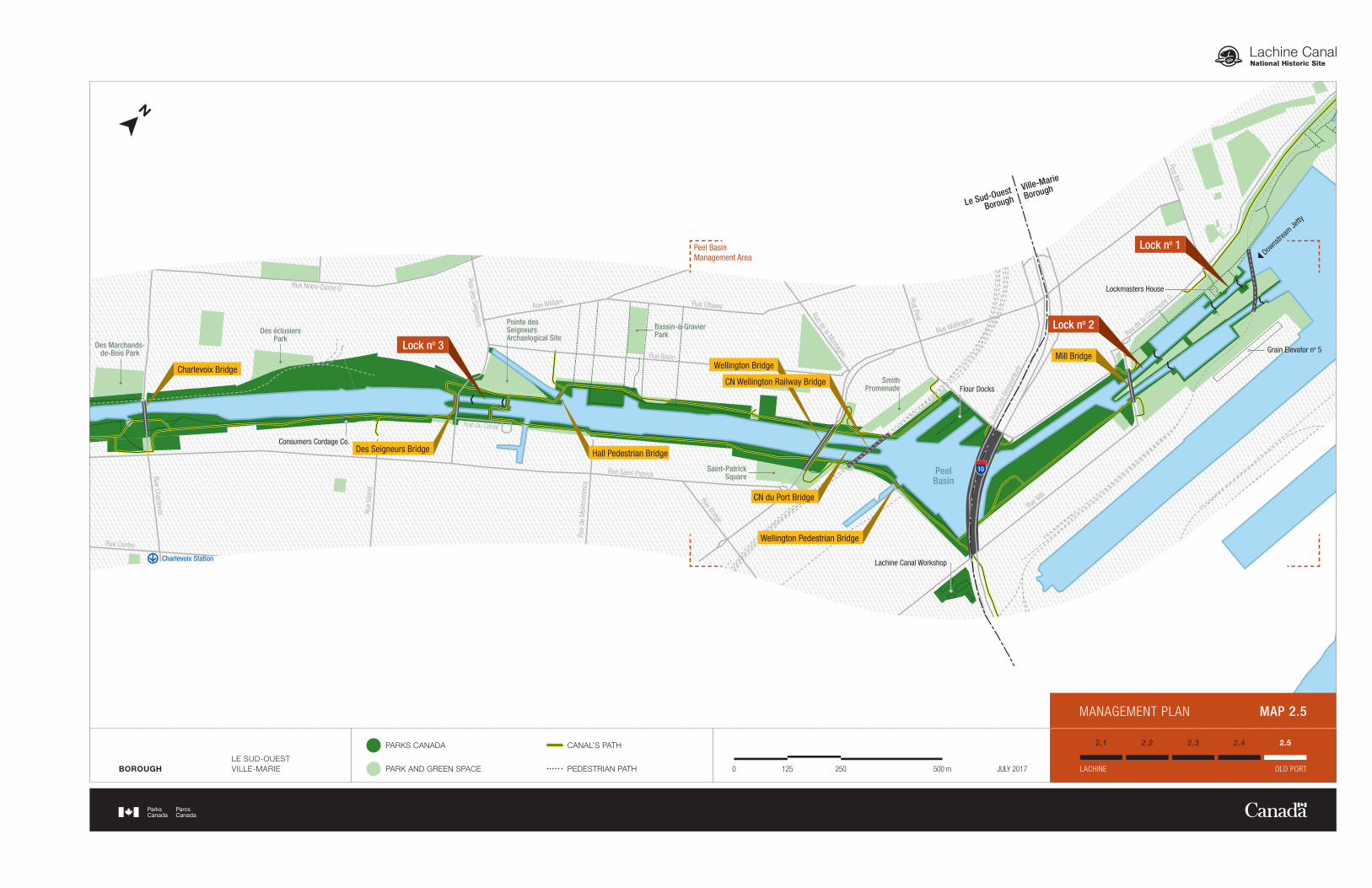
MANAGEMENT PLAN MAP 2.5
Lachine Canal National Historic Site 17
Management plan
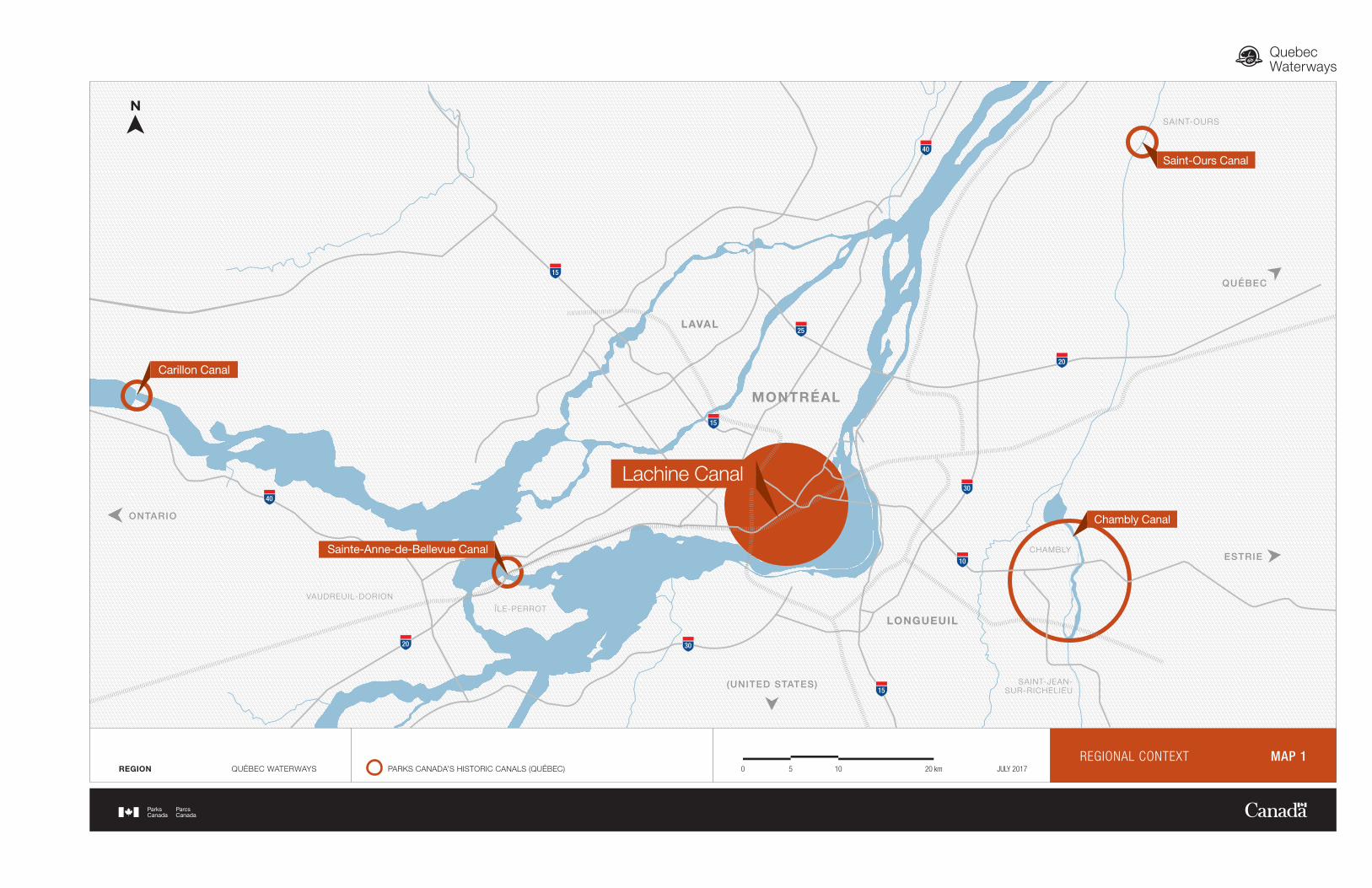
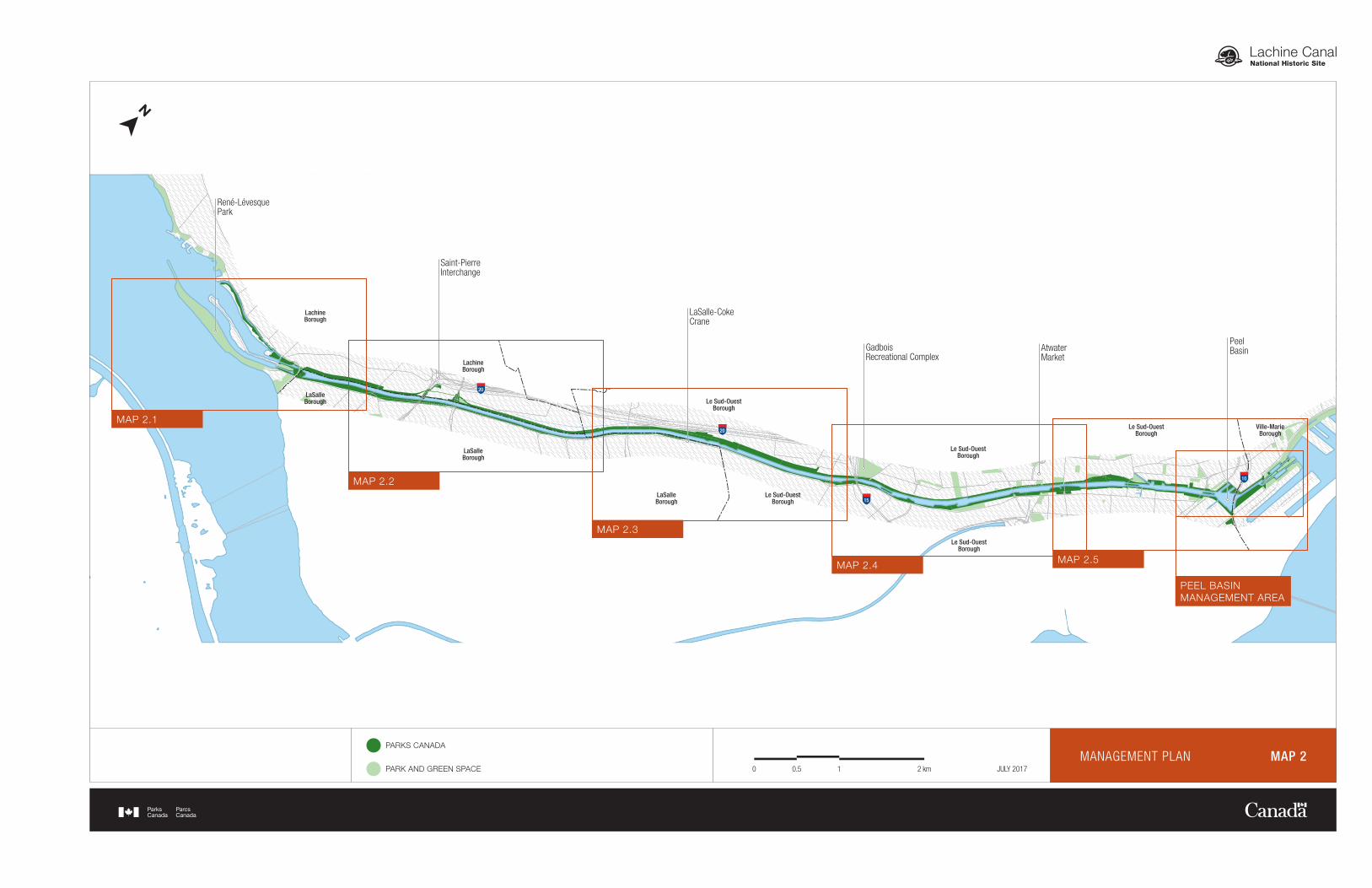
2.0 Significance of Lachine Canal National Historic Site The Lachine Canal is located in the heart of the City of Montreal. It consists of a 14.5 kilometre waterway comprised of five locks. The canal is bordered by a bustling multipurpose path which is connected to Montreal’s cycle network as well as the South Shore’s. The banks, used as a linear park, are popular for relaxation, contemplation of boats and for holding events and gatherings. The Lachine Canal is part of the five historic waterways managed by Parks Canada in Quebec.1 To these are added the Rideau Canal, Sault Ste-Marie Canal and Trent-Severn Waterway in Ontario as well as St-Peters Canal in Nova Scotia. These engineering works, which total 625 kilometres of waterways, have played a crucial role in the development and prosperity of the country. The Lachine Canal was designated a national historic site in 1929 for its determining role at the head of the Canadian canal system linking the heart of the continent to the Atlantic Ocean. Built for commercial purposes between 1821 and 1825, the canal allowed the transport of a variety of goods and merchandise to the Canadian and United States markets or abroad for export. Because of its hydraulic potential, the canal also favoured the establishment of important industrial complexes along its shores. Companies in a variety of sectors of the economy created thousands of jobs along the canal, leading to the recognition of the Lachine Canal as the first Canadian industrial corridor. Attracted by these employment opportunities, workers and their families sought to settle near their places of work, which contributed to the growth of the adjacent working-class neighbourhoods. The Lachine Canal was thus an important factor in the growth of Montreal, having contributed significantly to its economic, industrial and urban development. Even today, the Lachine Canal is a Montreal landmark. It attracted more than 1.2 million people in 2016, including more than 4,500 recreational boaters. Located at the limits of the «Quartier de l’Innovation» and the effervescent Griffintown neighbourhood, the Lachine Canal is of "exceptional heritage value", according to the City of Montreal’s urban planning documents. A number of manufacturing complexes that contributed to the notoriety of the site as an industrial corridor have now disappeared, but remnants of this glorious era still exist and shape its landscape. The preservation of their characteristics and their architecture have helped to maintain a unique character that is prized by industrial heritage lovers as well as trendy urbanites seeking innovative and unique places.
3.0 Planning Context The most recent management plan for the Lachine Canal National Historic Site was tabled in Parliament in 2004 and its objectives reflected the canal's reopening in 2002, after having been non-operational for more than 30 years. Closed to commercial shipping in 1970, the canal was reopened to recreational boating following public investments of $110 million by both the City of Montreal and the Federal Government. Several objectives of the 2004 management plan have been successfully achieved, including: the establishment of a meaningful dialogue with local public and private partners, a greater ownership of the site by users and nearby residents as well as increased efforts to integrate with adjacent communities. However, other approaches must be considered in light of the important changes taking place in the surrounding urban areas over the last decade, as well as the operational reality of the canal.
1 The four other Quebec waterways are : Chambly Canal, St-Ours Canal, Sainte-Anne-de-Bellevue Canal and Carillon Canal
18
The enhancement of the canal banks carried out in the late 1970s gave the site a new purpose as a linear park, in addition to directly contributing to the redevelopment of adjacent neighbourhoods. The development of the canal as a recreational corridor also launched important real estate developments and sparked a great desire for the enhancement of the waterway by its riverside residents. In recent years, the canal and its surroundings have undergone major changes, its landscape being transformed as a result of demolitions, the conversion of old industries to residential and commercial purposes as well as the construction of new buildings. Important infrastructure projects, owned by other public entities also affect canal property and require considerable effort to mitigate their impacts and to ensure the preservation of the site's historic values. For their part, visitors continue to come in large numbers and express the desire to access renewed facilities and additional services. The canal is used as a tranquil green space located within a dense urban environment. More and more events, some of them local in scope, others that are larger, are also held along the canal and contribute to its notoriety. The state of the site assessment conducted in 2016 revealed that the urban context, as well as the high level of visitation affect the condition and the maintenance of the canal property and its assets. In this context, ensuring public safety and the protection of the site's cultural resources become an issue. The Lachine Canal must also cope with the high expectations of the surroundings under full redevelopment and the large number of stakeholders with sometime divergent objectives. Nevertheless, the growing reputation of the Canal in Montreal’s tourist and cultural activities has led to numerous initiatives by the community as well as many opportunities. The remaining challenge is to support and channel this interest for the canal into opportunities to maintain or even increase the activities and amenities available to users in such a way that they can benefit from an improved visitor’s experience. In 2015, the Lachine Canal launched a significant rehabilitation program for its infrastructure over a 5-year period, made possible by a Federal investment of $130 million, which represents more than the initial amount granted to the reopening of the canal in 2002. This investment program will help rehabilitate infrastructure, the condition of which has deteriorated, especially the canal's masonry walls, locks, overflow weirs as well as bridges, pedestrian bridges and multifunctional path. These important investments will also ensure the sustainability of water retention and flow management structures and as a consequence, public safety. The effects of such important public investments will exceed the limits of the Federal property on the Lachine canal and will certainly benefit the surrounding neighbourhoods. All of these projects and initiatives resulted in the Lachine Canal to position itself in an evolving environment and to adapt its management priorities. This plan thus aims to update the strategic management direction to ensure that the Lachine Canal National Historic Site has a future that lives up to its potential and the aspirations of the communities that border and enliven it.
4.0 Vision
The vision below expresses the desired state of the Lachine Canal National Historic Site for the long term, around 2030.
The waterways managed by Parks Canada were once vital links for transportation and economic activity in Canada. Today they continue to perpetuate this tradition in many Canadian communities by contributing to their socio-economic development. Parks Canada will work in partnership with others to transform the canals, both the water and the land, into world-class
Lachine Canal National Historic Site 19 Management plan
sites, vibrant and animated, fostering recreation, tourism and economic development, while preserving the natural, historic and cultural environment for future generations. Internationally recognized emblem of Montreal for the development of its heritage symbols and its cultural animation, the Lachine Canal is an inspiring place. Visitors come to enjoy its historical components and industrial memory, preserved and evoked with authenticity and respect. Visitors are responsive to its journey of discovery and appreciate the crucial role played by the canal as an engine of economic development, not only for the Montreal agglomeration, but also for the country as a whole. As a fundamental part of its past and present character, the canal’s urbanity gives it a strong and distinctive signature, combining heritage and innovation. The development of its banks reflects recent changes and the needs of new clienteles that wish to explore the site. Its natural setting has also made it a valued green corridor in the heart of the city. The Peel Basin is once again a veritable hub, bringing together visitors in a festive manner and encouraging them to pursue the exploration of the canal’s different sectors and to live a variety of innovative experiences in an unparalleled environment. The Lachine Canal is also a collective asset integrated in its environment and is open to opportunities. Formerly a commercial waterway, the canal now embodies its role as a catalyst of urban redevelopment. It encourages dialogue between neighbouring communities and the many visitors who stroll along its banks. It is a reflection of communities’ commitment to its protection and its activities, and represents, like no other, a lever of economic and community development. As a cornerstone of Montreal’s history, it reflects the pride and the resilience of a community whose environment is in constant evolution. Whether as a waterway, as a hydraulic infrastructure or as a motor for economic and urban development, the canal has been and continues to be an eloquent demonstration of Canadian genius and expertise. A true flagship in an urban environment, the Lachine Canal is a privileged site to display the unique expertise of Parks Canada and the vast network of Canadian heritage sites.
5.0 Key Strategies The strategic direction for the management of the Lachine Canal National Historic Site includes four key strategies. They aim to enable the historic site to renew itself, taking into account the main issues and emerging trends as well as to be better promoted and appreciated by Canadians by taking advantage of the site's opportunities. The key strategies outlined below reflect the expectations expressed by the various communities surrounding the Lachine Canal. They describe the main approaches to managing the site over the next ten years in order to achieve the desired vision in the longer term (around 2030). Specific objectives relate to each of these key strategies and associated targets aim to measure progress toward these goals in the coming years.
20
Key strategy No. 1 The Lachine Canal: a Montreal emblem!
This strategy aims at providing the Lachine Canal with a strong and cohesive identity that will acknowledge its role as an innovative historic site preserving industrial heritage in an urban setting. In a metropolitan and competitive context, a distinctive signature based mainly on the heritage values specific to the canal will contribute to making it an emblematic place in Montreal, a prime destination both for local and international visitors alike. This unique signature as well as the preservation of its values and cultural resources will enable the Lachine Canal to join the ranks as a leading player in the tourism and cultural sphere of the greater Montreal area.
Objective 1.1: The redevelopment of the Lachine Canal is distinctive in its urban approach and emphasizes the participation of innovative and creative stakeholders of the Montreal community. o Target: Public competitions for urban initiatives will be launched by 2027.
Objective 1.2: The condition and integrity of cultural resources associated with the canal's engineering works and buildings are improved.
o Target: The canal’s buildings and engineering works are assessed to be in good condition
by 2025.
Objective 1.3: Dialogue with the City of Montreal's borough urban planning
departments is maintained and improved in order to reinforce the uniqueness of the Lachine Canal's urban cultural landscape. o Target: At least one annual meeting is held with each of the boroughs along the canal.
Key strategy No. 2 A renewed visitor experience
This strategy focuses on the renewal and improvement of the visitor experience offered to canal visitors in order to meet the new expectations of different users and those created by the redevelopment of adjacent neighborhoods. In particular, this strategy aims to increase services offered, recreation and learning opportunities as well as to better reflect recent changes in the surrounding urban communities. Ultimately, the canal will be sought for its unique corridor, an inviting route to the discovery of an authentic heritage, the contemplation of its waterway and relaxation in a green landscape.
Objective 2.1: The visitor experience is enhanced and the full development potential of the
canal is achieved.
o Target: Basic services are optimized in the different sectors of the canal by 2027. o Target: Visitor satisfaction with the overall service offer and the condition of the facilities
will increase by 5% by 2025.
Lachine Canal National Historic Site 21 Management plan
Objective 2.2: A Master Plan is devised and innovative experiences are offered to visitors for each of the canal’s sectors, reflecting their history and unique features.
o Target: An iconic cultural resource (located on Parks Canada property) is showcased in
each of the canal’s sectors by 2027. o Target: The "learning" indicator improves from red to yellow in the next state of
the site assessment in 2026. o Target: The function of the Lachine Visitor Services Centre is redefined by 2019.
Objective 2.3: Cyclists and strollers appreciate a variety of experiences and paths available,
either on the canal banks, in adjacent neighborhoods or in other Parks Canada sites that welcome cyclists.
o Target: Improvements to increase fluidity and user safety in the busiest sections of the
multifunctional path will be carried out by 2027. o Target: The "North Link" of the multifunctional path* is developed by 2020.
(* between Charlevoix and des Seigneurs streets on the north shore of the canal). o Target: New cycling routes are offered to users by 2022, in collaboration with the
boroughs of the City of Montreal and other Parks Canada historic sites or national parks.
Objective 2.4: Public docks and services for recreational boaters are added.
o Target: Night mooring stations with electricity are available to boaters by 2027. o Target: Two new public accesses to the canal for non-motorized boats are added by
2022. Objective 2.5: In collaboration with its partners, the canal offers a variety of activities
throughout the year. o Target: A winter activity concept is implemented by 2022; o Target: The number of permits issued for activities increases by 10% by 2022.
Key strategy No. 3 An important collective asset, a development force for communities
Since its reopening, the Lachine Canal has been an important lever in the redevelopment of surrounding neighbourhoods and has resulted in significant benefits for these communities and for the City of Montreal. This strategy seeks to increase the scope of this important collective asset and to reinforce its positive impact on communities. It also seeks to reaffirm the public ownership of the site and its integration with the communities that border it and that make it their own. Finally, this key strategy relies on strong partnerships to support Parks Canada in achieving its vision in the long term for the Lachine Canal.
22
Objective 3.1: The communities rally for the canal and actively contribute to its activities and its outreach through the establishment of a new partnership approach.
o Target: A Public Art Policy is developed in collaboration with communities by
2020. o Target: New sites are available to encourage citizen initiatives and activities. o Target: A round table, including communities and boroughs, is established by 2022,
in order to better coordinate protection and development initiatives. Objective 3.2: Increasing canal visitation generates socio-economic and community
development opportunities for stakeholders in adjacent communities.
o Target: New North-South connections are established with adjacent neighborhoods. o Target: By 2027, new cycling circuits are created to extend positive impacts of
tourism to the surrounding neighborhoods.
Key strategy No. 4 An exceptional showcase on history and innovation
Parks Canada possesses a unique expertise in the management and the operation of a historic canal. Due to the urban location of the Lachine Canal, Parks Canada is well positioned to demonstrate its expertise to a wide audience but also to publicize and promote the vast network of heritage sites managed by the Agency. This strategy aims to make the Lachine Canal a flagship of Parks Canada, a unique historic site whose reputation is reflected throughout the entire Agency.
Objective 4.1: The Lachine Canal is a privileged site within Parks Canada for raising awareness to its mission and historic sites, national parks and marine conservation areas managed by the Agency.
o Target: At least one citizenship ceremony for new Canadian citizens is held
annually at the canal. o Target: Two Parks Canada promotional events or national initiatives are held at the
canal each year. o Target: Partnerships are established with Montreal universities and with the
«Quartier de l’Innovation». o Target: By 2027, a dynamic showcase concept is established in the Atwater area to
better welcome visitors and to promote the identity of the Lachine Canal and Parks Canada.
Objective 4.2: In collaboration with the national outreach/cultural program, the Lachine Canal is actively involved in increasing awareness of historic sites, national parks and marine conservation areas.
o Target: By 2020, 25,000 people are contacted annually by Parks Canada
promotion teams.
Lachine Canal National Historic Site 23 Management plan
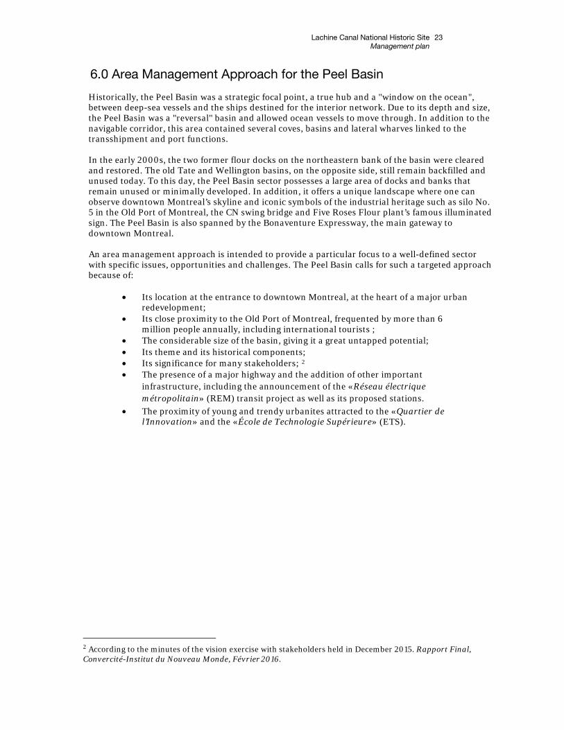
6.0 Area Management Approach for the Peel Basin
Historically, the Peel Basin was a strategic focal point, a true hub and a "window on the ocean", between deep-sea vessels and the ships destined for the interior network. Due to its depth and size, the Peel Basin was a "reversal" basin and allowed ocean vessels to move through. In addition to the navigable corridor, this area contained several coves, basins and lateral wharves linked to the transshipment and port functions. In the early 2000s, the two former flour docks on the northeastern bank of the basin were cleared and restored. The old Tate and Wellington basins, on the opposite side, still remain backfilled and unused today. To this day, the Peel Basin sector possesses a large area of docks and banks that remain unused or minimally developed. In addition, it offers a unique landscape where one can observe downtown Montreal’s skyline and iconic symbols of the industrial heritage such as silo No. 5 in the Old Port of Montreal, the CN swing bridge and Five Roses Flour plant’s famous illuminated sign. The Peel Basin is also spanned by the Bonaventure Expressway, the main gateway to downtown Montreal. An area management approach is intended to provide a particular focus to a well-defined sector with specific issues, opportunities and challenges. The Peel Basin calls for such a targeted approach because of:
• Its location at the entrance to downtown Montreal, at the heart of a major urban
redevelopment; • Its close proximity to the Old Port of Montreal, frequented by more than 6
million people annually, including international tourists ; • The considerable size of the basin, giving it a great untapped potential; • Its theme and its historical components; • Its significance for many stakeholders; 2 • The presence of a major highway and the addition of other important
infrastructure, including the announcement of the «Réseau électrique métropolitain» (REM) transit project as well as its proposed stations.
• The proximity of young and trendy urbanites attracted to the «Quartier de l’Innovation» and the «École de Technologie Supérieure» (ETS).
2 According to the minutes of the vision exercise with stakeholders held in December 2015. Rapport Final, Convercité-Institut du Nouveau Monde, Février 2016.
Ville-Marie
BoroughLe Sud-Ouest
Borough
Griffintown
Quartier de l’Innovation (ETS)
Port of Montréal
Pointe-Saint-Charles
Cité dumultimédia
Old Port of Montréal
Rue William
Rue Notre-Dame O
Rue Mill
Auto
rout
e Bo
nave
ntur
e
Rue de
la Com
mune O
Rue Wellington
Rue Welli
ngton
Rue Peel
Rue Duke
Rue King
Rue Murray
Rue McGill
Rue Ottawa
Rue Basin
Rue
du S
émin
aire
Rue de la Montagne
Rue des Seigneurs
Rue Bridge
Rue Saint-Patrick
Rue du Canal
Rue
Char
levo
ix
Rue Centre
Rue
d’Ar
gens
on
Rue
Isla
nd
Rue
de M
ontm
oren
cy
Aven
ue A
twat
er
Rue Saint-Ambroise
Rue de Courcelle
Rue Beaudoin
Chemin de la
Côte-Sain
t-Paul
Rue T
hom
as-K
eefe
r
Rue Saint-Patrick
Rue Saint-Rémi
Rue Ea
die
Avenue de l’Église
Rue Saint-Patrick
Rue Irwin
Rue Senkus
Boul. Angrignon
Rue Notre-Dame Ouest
Boule
vard
Mon
k
Boul
. Mon
k
Rue Philippe Turcot
Place Turcot
ÉchangeurSaint-Pierre
Gare du Canal
ÉchangeurTurcot
Rue Saint-Patrick
Rue Lapierre
Rue Léger
Aven
ue D
olla
rd
Rue Clément
Boul. Saint-Joseph
Boul. Saint-Joseph
10e Av
enue
15e Av
enue
6e Av
enue
18e Avenue
Chemin des Iroquois
Rue Notre-Dame Ouest
Rue de la Berge-du-Canal
Rue Saint-Patrick
Aven
ue St
irling
Chemin
du M
usée
Marina deLachine
Peel Basin
Windmill-PointBasin
AlexandraBasin
BickerdikeBasin
OldWellington
Basin
Old TateBasin
Écluse no 3
Écluse no 4
Lock no 1
Mill Bridge
Wellington Bridge
Pont Charlevoix
Pont des Seigneurs
Passerelle Atwater
Tunnel Atwater
Pont CN Saint-Henri
Tunnel Saint-Rémi
Pont de Côte-Saint-Paul
Passerelle Georges-Étienne-Cartier
CN Wellington Railway Bridge
CN du Port Bridge
Wellington Pedestrian Bridge
Lock no 2
Saint-PatrickSquare
SmithPromenade
Des ÉclusesGarden
Faubourg-Sainte-Anne
Park
Olier Park
Site archéologique de la Pointe des Seigneurs
Parc des éclusiersParc des
Marchands-de-Bois
ParcGédéon-de-
Catalogne
Parc de l’ancienne-cour-de-triage
Parc Georges-Étienne-
Cartier
ParcMadeleine-
Parent
Parc du Bassin-à-Gravier
Grain Elevator no 5
Lockmasters House
Flour Docks
10
Consumers Cordage Co.
Marché Atwater
Complexe récréatif Gadbois
15
Pont Monk
Grue LaSalle-Coke
15
Passerelle de la Grue
Passerelle des Trinitaires
Pont Lafleur
Pont Gauron
20
20
138
Pont CP Rockfield
Parc Dollier-de-Casson
Lac Saint-Louis
FleuveSaint-Laurent
ParcRené-
Lévesque
Île Monk
Écluse no 5
Centre de servicesaux visiteurs
Lieu historique national du Canada du Commerce-de-la-Fourrure-à-Lachine
PromenadePère-Marquette
Amont
Métro Charlevoix
BOROUGHLE SUD-OUESTVILLE-MARIE
PARKS CANADA
PARK AND GREEN SPACE
CANAL’S PATH
PEDESTRIAN PATH 100500 200 m JULY 2017PEEL BASIN MANAGEMENT AREA
MANAGEMENT PLAN MAP 3
Lachine Canal National Historic Site 27 Management plan
All these elements taken together grant a special status to the area, as well as a high visibility and a considerable potential for development and heritage presentation. The Peel Basin can aspire to become a driving force for the Lachine Canal and even reacquire its role as a hub, as an attractive point of convergence for the Montreal community and tourists alike. The achievement of this strategy requires strong and strategic partnerships as well as a concerted and affirmed development vision. Objectives specific to the Peel Basin Area Community partners collaborate with Parks Canada to develop a collective
development vision for the Peel Basin area and commit to integrate it into their respective projects to strengthen the unique identity of the site.
o Target: A committee is established by 2019, in order to translate and rally the interests
of each stakeholder for the development of the sector. o Target: By 2021, the Peel Basin Master Plan is accomplished in collaboration with this
committee. o Target: With respect to its mandate, Parks Canada participates in the planning of major
urban projects in the area. The Peel Basin is a veritable gateway to the canal and its connections with the
surrounding communities are maximized.
o Target: By 2025, in collaboration with the City of Montreal, the main access points to the Peel Basin are clearly recognizable with appealing landscapes.
o Target: The connection with the Old-Port of Montreal is established in priority and by 2022, its design is given specific consideration.
o Target: By 2027, connections and paths promoting active modes of transit are developed.
The uniqueness of the Peel Basin is celebrated through innovative activities and
experiences that combine both water and heritage symbols of the site and the surrounding areas.
o Target: By 2022, a call for proposals is launched to develop a signature
experience and to enliven/animate the area. o Target: At least two interventions or projects that highlight the site’s
heritage are implemented by 2023. o Target: In partnership with public, community or private organizations, a multi-
service centre is established at the Peel Basin by 2023 to meet the needs of various users.
28
7.0 Summary of Strategic Environmental Assessment Parks Canada is responsible for assessing and mitigating the impacts of management actions on ecosystems and on cultural resources. The Cabinet Directive on the Environmental Assessment of Policy, Plan and Program Proposals prepared by the Canadian Environmental Assessment Agency, requires a strategic environmental assessment of all plans and policy submitted to the federal Cabinet or to a Minister for approval deemed to have important positive or negative environmental effects. A strategic environmental assessment was undertaken on this management plan, and the management direction found within has been adjusted to respond to findings. The following is a summary of the environmental assessment:
"In accordance with the Cabinet Directive on the Environmental Assessment of Policy, Plan and Program Proposals (2004), a strategic environmental assessment was conducted on the proposed Lachine Canal National Historic Site Management Plan.
Strategic environmental assessment of management plans provide an opportunity to identify the general and unintended impacts of the proposed management actions and to assess the cumulative effects of multiple activities on the environment. The strategic environmental assessment evaluated the potential effects on natural and cultural resources and on visitor experience objectives. In this respect, the potential negative effects, including cumulative effects, on natural and cultural resources and visitor experience should be minimal. Impact assessments at the project level will address the potential negative effects of individual projects and activities on the site. The Strategic Environmental Assessment concluded that the proposed Lachine Canal National Historic Site Management Plan would have several positive effects on cultural resources and visitor experience and should not result in significant negative effects."