Embed Size (px)
Citation preview
CODEN: BSVAA6 2012 © Société vaudoise des Sciences naturellesDroits de reproduction réservés
ISSN 0037-9603Bull. Soc. vaud. Sc. nat. 93.1: 13-20
The Broye Graben System:a tectonically active graben in a compressional environment
par
Michael DIeM 1, Marius GruBer 1, Tobias IBele 2 & Jon MoSar 1*
abstract.–DiEm m., GruBEr m., iBElE T. & mOSAr J., 2012. The Broye Graben System: a tectonically active graben in a compressional environment. Bulletin de la Société vaudoise des Sciences naturelles 93.1: 13-20.The identification of normal faults affecting deltaic sediments of Pleistocene age in a gravel pit near Granges-près-marnand suggests a recent normal fault activity. insight into the geology of the Broye valley by seismic data has shown the existence of listric faults linked to the formation of a graben structure: the Broye Graben. The conjugate normal faults observed in the gravel pit strike parallel to the Broye valley and are located in the upward prolongation of the normal faults delineating the graben on its NW side. We suggest that the observed extensional fault system can be linked to the Broye Graben System. This would point to neotectonic, possibly recent, activity in the Broye Graben System.
Keywords: Broye Graben, normal faults, recent tectonics.
résumé.–DiEm m., GruBEr m., iBElE T. & mOSAr J., 2012. le Graben de la Broye: un graben tectonique actif dans un environnement compressif. Bulletin de la Société vaudoise des Sciences naturelles 93.1: 13-20.la découverte et l’analyse de failles normales dans des sédiments deltaïques du Pléistocène dans une gravière près de Granges-près-marnand suggèrent une activité tectonique récente. les résultats d’études sur les données sismiques de la région du plateau Suisse et plus particulièrement la vallée de la Broye montrent que cette dernière est une structure en graben qui affecte l’ensemble des séries géologiques jusque dans le Trias au-dessus du socle. le système de failles conjuguées découvert dans la gravière de Granges-près-marnand est parallèle aux failles de la partie NW du graben et en constituerait une prolongation vers la surface. Ces failles indiquent une extension subhorizontale orientée NW-SE. Cette découverte pourrait indiquer une activité néotectonique du système de failles du Graben de la Broye.
Mots clés: Graben de la Broye, failles normales, tectonique récente.
1 Department of Geosciences – Earth Sciences, univ. Fribourg, chemin du musée 6, CH-1700 Fribourg, Switzerland.2 Geosfer AG, Glockengasse 4, CH-9008 St Gallen. E-mail: [email protected]*corresponding author - E-mail: [email protected]
M. Diem, M. Gruber, T. Ibele & J. Mosar14
IntroductIon
The SW-NE striking Broye valley is located in the Western Swiss molasse Basin south of lake Neuchâtel (figure 1). it is bordered by steep slopes and occasional cliffs on the northern side, which are formed by lower Freshwater molasse (uSm, Aquitanian) and upper marine molasse (Omm, Burdigalian) (WeIdmann 1996), whereas the southern rim steps up more gently from the valley floor to the surrounding plateau. This very straight valley is 2 km broad at its NE tip and narrows towards the SW. The valley floor is around 460-470 m whereas the edges rise above 650 m, both to the North and to the South. it is filled with alluvial or fluvioglacial deposits (late Pleistocene to Holocene age) of about 200 m thickness between lucens and Granges-près-marnand (WeIdmann 1996 & 2002).
To the NE the Broye Graben is abutting against the south-eastern termination of the NW-SE oriented la lance strike-slip fault system. The la lance fault can be observed in the molasse Basin and extends across lake Neuchâtel, where it is subdivided in two branches. The right-lateral movement component is very well documented in the Jura mountains to the west of mont Aubert (meIa 1969, dIem 2012, Gruber 2012). interpretation of seismic data from a survey in lake (GorIn et al. 2003) shows evidence for neotectonic activity of the la lance fault, since the fault, which here has two strings, offsets the Quaternary infill at the lake bottom. To the SE the la lance fault terminates against NE-SW trending thrust faults associated with the Courtion anticlinal structure and the NE tip of the Broye Graben (figure 1).
The structural interpretation of oil exploration seismic data of the Western molasse Basin indicates the occurrence of several normal faults in the mesozoic units below the Broye valley. These faults are interpreted to cut through the Tertiary units as well and reach the surface (SommaruGa et al. 2011, SommaruGa 2011). These listric faults are located below the valley floor and can be followed along the valley. They show a normal offset in the northern section corresponding to the northern edge of the valley and a reverse offset in the southern section. The Broye valley thus forms an extensional graben structure that stretches from the city of moudon in the SW to Payerne in the NE. However, the overall regional paleostress field shows a NW-SE directed compression, as reconstructed from fault and striation analysis on surface faults (Ibele 2011). interestingly the southern termination of the graben structure, near the city of moudon, shows a more compressional state (Ibele 2011).
The occurrence of an extensional fault system in a general regional NW-SE (Neogene) compressional stress field can be explained by the presence of a triple junction with the SE tail of the la lance strike-slip fault. indeed, this WNW-ESE striking right-lateral strike slip fault is located at the NE tip of the Broye Graben structure (ParrIaux 1981, axelrod 1978 in: WeIdmann 2006, moSar et al. 2011, Ibele 2011). The interaction between the right-lateral strike-slip fault and the graben structure allows the local accommodation of extension in the northern part of the Broye Graben, whereas the southern portion suffers inversion (figure 1).
The Broye Graben System 15
normal faultInG In GranGeS-PrèS-marnand
We investigated a gravel pit near Granges-près-marnand, located along the northern part or the NE edge of the Broye Graben. The gravel pit is situated right above the possible prolongation of the normal faults associated with the northern border of the graben system.
Pleistocene deltaic sedimentary deposits are exploited in the pit. They are composed of gravels (cm to >10 cm diameter), sand and silt layers deposited in a periglacial lake during the last glacial retreat (ParrIaux 1979, tISSIèreS 1990). They show a succession of foreset beds (basal gravel layer) dipping 10-30° towards the East, which are overlain by several horizontal topset beds containing sand and silt layers (ParrIaux 1979). The basal gravel layer (“foreset unit” in Tissières 1990, see figure 6 and 7 therein for detailed geological profiles) is at least 12 m thick. The floor of the quarry does not reach the base of this layer, which is estimated to be at a depth of 14-15 m beneath the top of the foreset unit (2-3 m below present quarry floor; Creabeton, oral communication). in the near vicinity, the depth to top molasse sediments is known to be in excess of 30 m beneath the surface from borehole data (WeIdmann 1996).
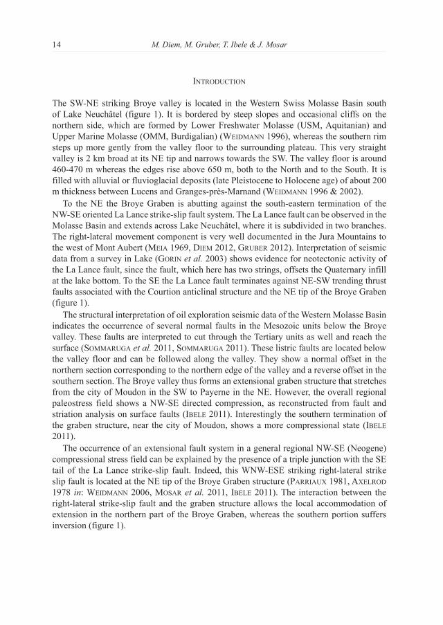
Figure 1.–interpretation model of the Broye Graben System.1: Sketch map of structures around the Broye valley with localization of profiles A-B and C-D. The part of the Broye valley between Payerne and moudon is in an extensional state, whereas a compressional regime is present south of moudon (Ibele 2011). The compressional zone of the Courtion structure, the transversal zone of the la lance fault and the extensional zone of the Broye structure are also shown (after Ibele 2011).2: Cross section through the Quaternary deltaic sediments. The deformation in the foreset beds is interpreted as the prolongation of listric faults seen in the mesozoic and Tertiary units. The overlying topset beds are an indicator of minimal age of fault activity.3: Cross section through the Broye valley with the existing normal faults in the mesozoic units and their interpreted prolongation in the Tertiary (after SommaruGa 2011, SommaruGa et al,. 2011).
M. Diem, M. Gruber, T. Ibele & J. Mosar16
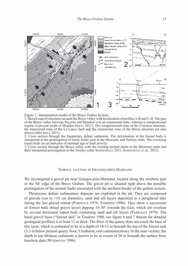
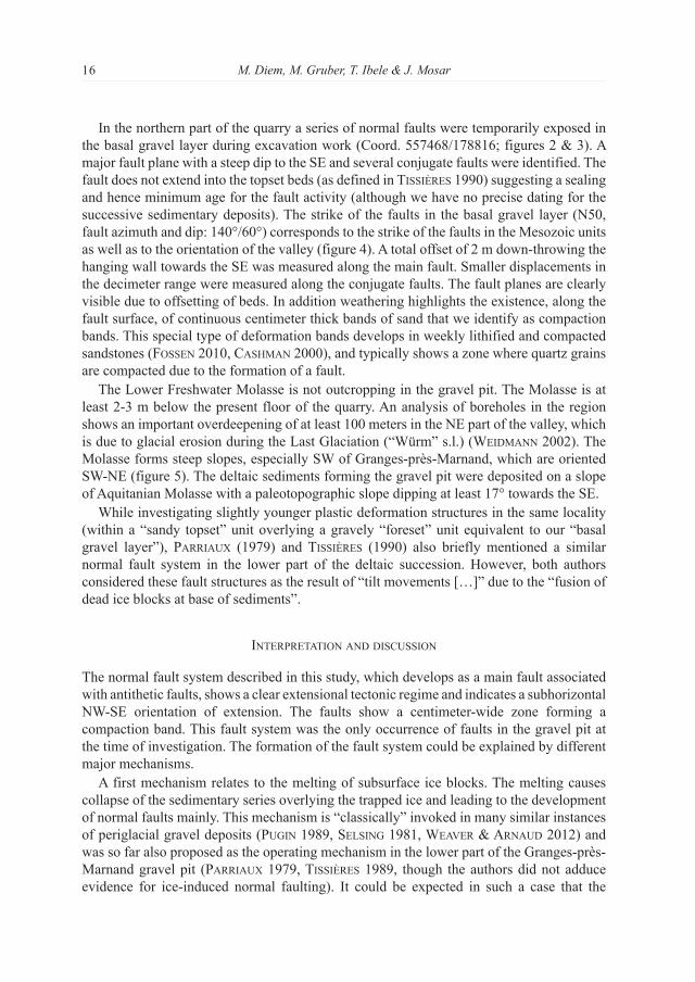
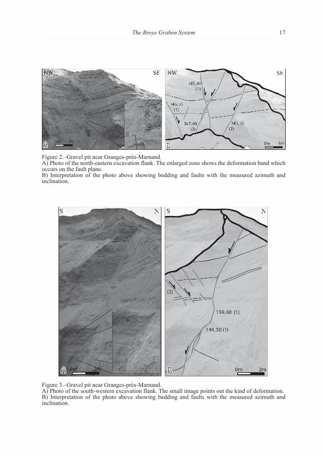
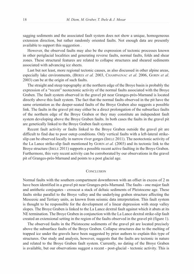
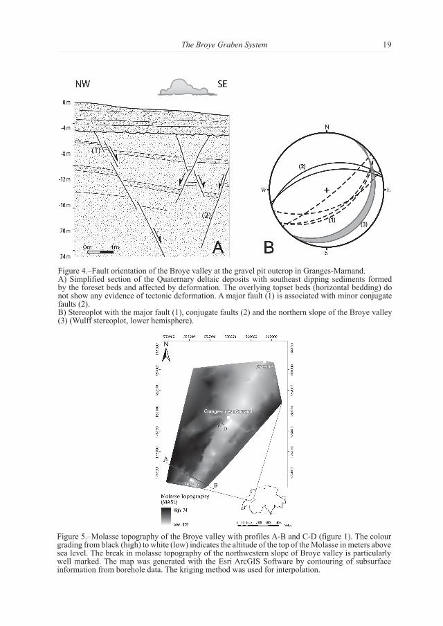
in the northern part of the quarry a series of normal faults were temporarily exposed in the basal gravel layer during excavation work (Coord. 557468/178816; figures 2 & 3). A major fault plane with a steep dip to the SE and several conjugate faults were identified. The fault does not extend into the topset beds (as defined in tISSIèreS 1990) suggesting a sealing and hence minimum age for the fault activity (although we have no precise dating for the successive sedimentary deposits). The strike of the faults in the basal gravel layer (N50, fault azimuth and dip: 140°/60°) corresponds to the strike of the faults in the mesozoic units as well as to the orientation of the valley (figure 4). A total offset of 2 m down-throwing the hanging wall towards the SE was measured along the main fault. Smaller displacements in the decimeter range were measured along the conjugate faults. The fault planes are clearly visible due to offsetting of beds. in addition weathering highlights the existence, along the fault surface, of continuous centimeter thick bands of sand that we identify as compaction bands. This special type of deformation bands develops in weekly lithified and compacted sandstones (foSSen 2010, caShman 2000), and typically shows a zone where quartz grains are compacted due to the formation of a fault.
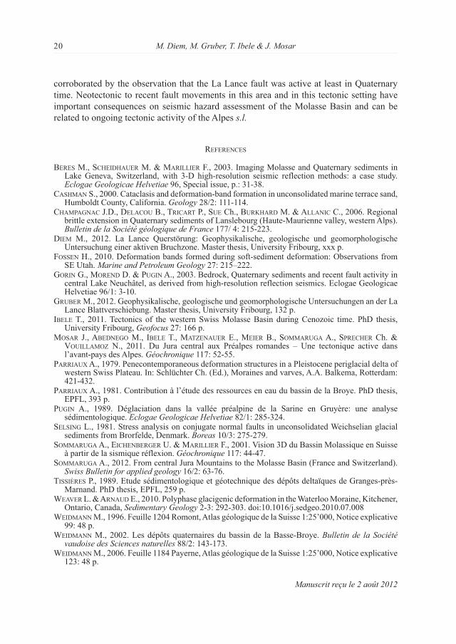
The lower Freshwater molasse is not outcropping in the gravel pit. The molasse is at least 2-3 m below the present floor of the quarry. An analysis of boreholes in the region shows an important overdeepening of at least 100 meters in the NE part of the valley, which is due to glacial erosion during the last Glaciation (“Würm” s.l.) (WeIdmann 2002). The molasse forms steep slopes, especially SW of Granges-près-marnand, which are oriented SW-NE (figure 5). The deltaic sediments forming the gravel pit were deposited on a slope of Aquitanian molasse with a paleotopographic slope dipping at least 17° towards the SE.
While investigating slightly younger plastic deformation structures in the same locality (within a “sandy topset” unit overlying a gravely “foreset” unit equivalent to our “basal gravel layer”), ParrIaux (1979) and tISSIèreS (1990) also briefly mentioned a similar normal fault system in the lower part of the deltaic succession. However, both authors considered these fault structures as the result of “tilt movements […]” due to the “fusion of dead ice blocks at base of sediments”.
InterPretatIon and dIScuSSIon
The normal fault system described in this study, which develops as a main fault associated with antithetic faults, shows a clear extensional tectonic regime and indicates a subhorizontal NW-SE orientation of extension. The faults show a centimeter-wide zone forming a compaction band. This fault system was the only occurrence of faults in the gravel pit at the time of investigation. The formation of the fault system could be explained by different major mechanisms.
A first mechanism relates to the melting of subsurface ice blocks. The melting causes collapse of the sedimentary series overlying the trapped ice and leading to the development of normal faults mainly. This mechanism is “classically” invoked in many similar instances of periglacial gravel deposits (PuGIn 1989, SelSInG 1981, Weaver & arnaud 2012) and was so far also proposed as the operating mechanism in the lower part of the Granges-près-marnand gravel pit (ParrIaux 1979, tISSIèreS 1989, though the authors did not adduce evidence for ice-induced normal faulting). it could be expected in such a case that the
The Broye Graben System 17
Figure 2.–Gravel pit near Granges-près-marnand.A) Photo of the north-eastern excavation flank. The enlarged zone shows the deformation band which occurs on the fault plane.B) interpretation of the photo above showing bedding and faults with the measured azimuth and inclination.
Figure 3.–Gravel pit near Granges-près-marnand.A) Photo of the south-western excavation flank. The small image points out the kind of deformation.B) interpretation of the photo above showing bedding and faults with the measured azimuth and inclination.
M. Diem, M. Gruber, T. Ibele & J. Mosar18
sagging sediments and the associated fault system does not show a unique, homogeneous extension direction, but rather randomly oriented faults. Not enough data are presently available to support this suggestion .
However, the observed faults may also be the expression of tectonic processes known in other periglacial localities and generating reverse faults, normal faults, folds and shear zones. These structural features are related to collapse structures and sheared sediments associated with advancing ice sheets.
last but not least, more regional tectonic causes, as also discussed in other alpine areas, especially lake environments, (bereS et al. 2003, chamPaGnac et al. 2006, GorIn et al. 2003) can be at the origin of such faults.
The straight and steep topography at the northern edge of the Broye basin is probably the expression of a “recent” neotectonic activity of the normal faults associated with the Broye Graben. The fault system observed in the gravel pit near Granges-près-marnand is located directly above this fault system. The fact that the normal faults observed in the pit have the same orientation as the deeper-seated faults of the Broye Graben also suggests a possible link. The faults in the gravel pit may either be a direct prolongation of the subsurface faults of the northern edge of the Broye Graben or they may constitute an independent fault system developing above the Broye Graben faults. in both cases the faults in the gravel pit are genetically linked to the Broye Graben fault system.
recent fault activity or faults linked to the Broye Graben outside the gravel pit are difficult to find due to poor outcp conditions. Only vertical faults with a left-lateral strike-slip can be observed locally in narrow river gorges (Ibele 2011). The neotectonic activity of the la lance strike-slip fault mentioned by GorIn et al. (2003) and its tectonic link to the Broye structure (Ibele 2011) supports a possible recent active faulting in the Broye Graben. Furthermore, this very recent activity can be corroborated by our observations in the gravel pit of Granges-près-marnand and points to a post glacial age.
concluSIon
Normal faults with the southern compartment downthrown with an offset in excess of 2 m have been identified in a gravel pit near Granges-près-marnand. The faults - one major fault and antithetic conjugates - crosscut a stack of deltaic sediments of Pleistocene age. These faults strike parallel to the Broye valley and the underlying graben structure affecting the mesozoic and Tertiary units, as known from seismic data interpretation. This fault system is thought to be responsible for the development of a linear depression with steep valley slopes. The Broye Graben is linked to the la lance dextral fault against which it abuts at its NE termination. The Broye Graben in conjunction with the la lance dextral strike-slip fault created an extensional setting in the region of the faults observed in the gravel pit (figure 1).
The observed faults in the Pleistocene sediments of the gravel pit are located precisely above the subsurface faults of the Broye Graben. Collapse structures due to the melting of trapped ice under the gravels have been suggested by prior authors to explain this type of structures. Our study and analysis, however, suggests that the faults are tectonic in nature and related to the Broye Graben fault system. Currently, no dating of the Broye Graben is available, but our observations suggest a recent - post-glacial - tectonic activity. This is
The Broye Graben System 19
Figure 5.–molasse topography of the Broye valley with profiles A-B and C-D (figure 1). The colour grading from black (high) to white (low) indicates the altitude of the top of the molasse in meters above sea level. The break in molasse topography of the northwestern slope of Broye valley is particularly well marked. The map was generated with the Esri ArcGiS Software by contouring of subsurface information from borehole data. The kriging method was used for interpolation.
Figure 4.–Fault orientation of the Broye valley at the gravel pit outcrop in Granges-marnand.A) Simplified section of the Quaternary deltaic deposits with southeast dipping sediments formed by the foreset beds and affected by deformation. The overlying topset beds (horizontal bedding) do not show any evidence of tectonic deformation. A major fault (1) is associated with minor conjugate faults (2).B) Stereoplot with the major fault (1), conjugate faults (2) and the northern slope of the Broye valley (3) (Wulff stereoplot, lower hemisphere).
M. Diem, M. Gruber, T. Ibele & J. Mosar20
corroborated by the observation that the la lance fault was active at least in Quaternary time. Neotectonic to recent fault movements in this area and in this tectonic setting have important consequences on seismic hazard assessment of the molasse Basin and can be related to ongoing tectonic activity of the Alpes s.l.
referenceS
bereS m., ScheIdhauer m. & marIllIer F., 2003. imaging molasse and Quaternary sediments in lake Geneva, Switzerland, with 3-D high-resolution seismic reflection methods: a case study. eclogae Geologicae Helvetiae 96, Special issue, p.: 31-38.
caShman S., 2000. Cataclasis and deformation-band formation in unconsolidated marine terrace sand, Humboldt County, California. Geology 28/2: 111-114.
chamPaGnac J.D., delacou B., trIcart P., Sue Ch., burkhard m. & allanIc C., 2006. regional brittle extension in Quaternary sediments of lanslebourg (Haute-maurienne valley, western Alps). Bulletin de la Société géologique de France 177/ 4: 215-223.
dIem m., 2012. la lance Querstörung: Geophysikalische, geologische und geomorphologische untersuchung einer aktiven Bruchzone. master thesis, university Fribourg, xxx p.
foSSen H., 2010. Deformation bands formed during soft-sediment deformation: Observations from SE utah. Marine and Petroleum Geology 27: 215–222.
GorIn G., morend D. & PuGIn A., 2003. Bedrock, Quaternary sediments and recent fault activity in central lake Neuchâtel, as derived from high-resolution reflection seismics. Eclogae Geologicae Helvetiae 96/1: 3-10.
Gruber m., 2012. Geophysikalische, geologische und geomorphologische untersuchungen an der la lance Blattverschiebung. master thesis, university Fribourg, 132 p.
Ibele T., 2011. Tectonics of the western Swiss molasse Basin during Cenozoic time. PhD thesis, university Fribourg, Geofocus 27: 166 p.
moSar J., abedneGo m., Ibele T., matzenauer E., meIer B., SommaruGa A., SPrecher Ch. & vouIllamoz N., 2011. Du Jura central aux Préalpes romandes – une tectonique active dans l’avant-pays des Alpes. Géochronique 117: 52-55.
ParrIaux A., 1979. Penecontemporaneous deformation structures in a Pleistocene periglacial delta of western Swiss Plateau. in: Schlüchter Ch. (Ed.), moraines and varves, A.A. Balkema, rotterdam: 421-432.
ParrIaux A., 1981. Contribution à l’étude des ressources en eau du bassin de la Broye. PhD thesis, EPFl, 393 p.
PuGIn A., 1989. Déglaciation dans la vallée préalpine de la Sarine en Gruyère: une analyse sédimentologique. eclogae Geologicae Helvetiae 82/1: 285-324.
SelSInG l., 1981. Stress analysis on conjugate normal faults in unconsolidated Weichselian glacial sediments from Brorfelde, Denmark. Boreas 10/3: 275-279.
SommaruGa A., eIchenberGer u. & marIllIer F., 2001. Vision 3D du Bassin molassique en Suisse à partir de la sismique réflexion. Géochronique 117: 44-47.
SommaruGa A., 2012. From central Jura mountains to the molasse Basin (France and Switzerland). Swiss Bulletin for applied geology 16/2: 63-76.
tISSIèreS P., 1989. Etude sédimentologique et géotechnique des dépôts deltaïques de Granges-près-marnand. PhD thesis, EPFl, 259 p.
Weaver l. & arnaud E., 2010. Polyphase glacigenic deformation in the Waterloo moraine, Kitchener, Ontario, Canada, Sedimentary Geology 2-3: 292-303. doi:10.1016/j.sedgeo.2010.07.008
WeIdmann m., 1996. Feuille 1204 romont, Atlas géologique de la Suisse 1:25’000, Notice explicative 99: 48 p.
WeIdmann m., 2002. les dépôts quaternaires du bassin de la Basse-Broye. Bulletin de la Société vaudoise des Sciences naturelles 88/2: 143-173.
WeIdmann m., 2006. Feuille 1184 Payerne, Atlas géologique de la Suisse 1:25’000, Notice explicative 123: 48 p.
Manuscrit reçu le 2 août 2012