THE LAKE CHAD DEVELOPMENT AND CLIMATE RESILIENCE ACTION PLANSUMMARY
102851 v1P
ublic
Dis
clos
ure
Aut
horiz
edP
ublic
Dis
clos
ure
Aut
horiz
edP
ublic
Dis
clos
ure
Aut
horiz
edP
ublic
Dis
clos
ure
Aut
horiz
ed

The Lake Chad Development and Climate Resilience Action Plan | 1
The Lake Chad Development and Climate Resilience Action Plan (LCDAP), or Plan de développement et d’adaptation au changement climatique du lac Tchad (PADLT), is an initiative undertaken by the Lake Chad Basin Commission (LCBC) and its six member countries: Cameroon, Central African Republic, Chad, Libya, Niger, and Nigeria.
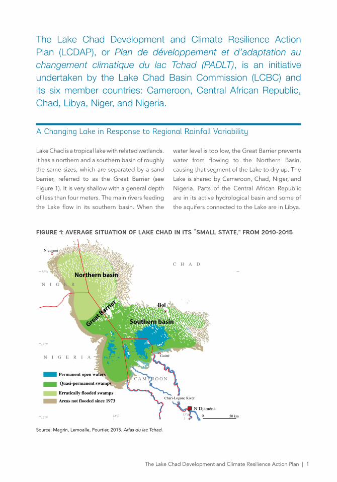
A Changing Lake in Response to Regional Rainfall Variability
Lake Chad is a tropical lake with related wetlands.
It has a northern and a southern basin of roughly
the same sizes, which are separated by a sand
barrier, referred to as the Great Barrier (see
Figure 1). It is very shallow with a general depth
of less than four meters. The main rivers feeding
the Lake flow in its southern basin. When the
water level is too low, the Great Barrier prevents
water from flowing to the Northern Basin,
causing that segment of the Lake to dry up. The
Lake is shared by Cameroon, Chad, Niger, and
Nigeria. Parts of the Central African Republic
are in its active hydrological basin and some of
the aquifers connected to the Lake are in Libya.
FIGURE 1: AVERAGE SITUATION OF LAKE CHAD IN ITS “SMALL STATE,” FROM 2010-2015
Source: Magrin, Lemoalle, Pourtier, 2015. Atlas du lac Tchad.
Northern basin
Southern basinGreat Barri
er
N I G E R
N I G E R I A
C H A D
C A M E R O O N
N’Djaména
N’guigmi
Bol
Permanent open waters
Quasi-permanent swamps
Erratically flooded swamps
Areas not flooded since 1973
0 50 km
Guitté
14°N
13°N
12°N 14°E 15°E
Chari-Logone River
2 | The Lake Chad Development and Climate Resilience Action Plan
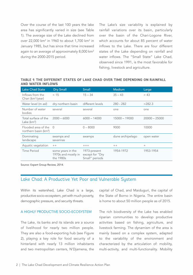
Over the course of the last 100 years the lake
area has significantly varied in size (see Table
1). The average size of the Lake declined from
over 22,000 km2 in 1960 to about 1,700 km2 in
January 1985, but has since that time increased
again to an average of approximately 8,000 km2
during the 2000-2015 period.
The Lake’s size variability is explained by
rainfall variations over its basin, particularly
over the basin of the Chari-Logone River,
which accounts for about 85 percent of water
inflows to the Lake. There are four different
states of the Lake depending on rainfall and
water inflows. The “Small State” Lake Chad,
observed since 1991, is the most favorable for
fishing, livestock and agriculture.
TABLE 1: THE DIFFERENT STATES OF LAKE CHAD OVER TIME DEPENDING ON RAINFALL AND WATER INFLOWSLake Chad State Dry Small Small Medium Large
Inflows from the Chari (km3/year)
< 15 15 – 34 35 – 43 > 43
Water level (m asl) dry northern basin different levels 280 - 282 >282.3
Number of water bodies
several several one one
Total surface of the Lake (km2)
2000 – 6000 6000 – 14000 15000 – 19000 20000 – 25000
Flooded area of the northern basin (km2)
0 0 – 8000 9000 10000
Dominating landscape
swamps and savannas
swamps dune archipelago open water
Aquatic vegetation ++ +++ ++ +
Time Period some years in the 1970s and mostly in the 1980s
1973-present except for “Dry Small” periods
1954-1972 1953-1954
Source: Expert Group Review, 2014.
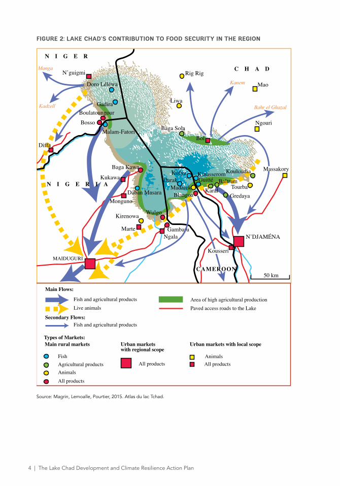
Lake Chad: A Productive Yet Poor and Vulnerable System
Within its watershed, Lake Chad is a large,
productive socio-ecosystem, yet with much poverty,
demographic pressure, and security threats.
A HIGHLY PRODUCTIVE SOCIO-ECOSYSTEM
The Lake, its banks and its islands are a source
of livelihood for nearly two million people.
They are also a food-exporting hub (see Figure
2), playing a key role for food security of a
hinterland with nearly 13 million inhabitants
and two metropolitan centers, N’Djamena, the
capital of Chad, and Maiduguri, the capital of
the State of Borno in Nigeria. The entire basin
is home to about 50 million people as of 2015.
The rich biodiversity of the Lake has enabled
riparian communities to develop productive
activities based on fishing, agriculture, and
livestock farming. The dynamism of the area is
mainly based on a complex system, adapted
to the variability of the environment and
characterized by the articulation of: mobility,
multi-activity, and multi-functionality. Mobility
2 | The Lake Chad Development and Climate Resilience Action Plan The Lake Chad Development and Climate Resilience Action Plan | 3
refers to people responding to changing natural
resources. Multi-activity means that a dominant
proportion of the population of the Lake practice
several activities (fishing, livestock, agriculture,
and also trade, and crafts) to secure revenues.
Multi-functionality refers to the successive use
of the same space for fishing, agriculture, and
livestock, following the rhythm of the annual
floods and flood recessions.
The value of Lake Chad resides therefore in
the ecosystem services it provides, and these
are particularly precious in its Sahelo-Saharan
regional environment characterized by aridity
and the erratic availability of water resources.
Recognized by the Ramsar Convention, the Lake
is being classified a World Natural Heritage Site
by UNESCO.
Photo credit: G. Margin
4 | The Lake Chad Development and Climate Resilience Action Plan
FIGURE 2: LAKE CHAD’S CONTRIBUTION TO FOOD SECURITY IN THE REGION
Source: Magrin, Lemoalle, Pourtier, 2015. Atlas du lac Tchad.
MAIDUGURI
Main rural markets Urban markets with regional scope
FishAgricultural products All products
Urban markets with local scope
Animals
AnimalsAll products
All products
Area of high agricultural production
Main Flows:
Secondary Flows:
Paved access roads to the Lake
Fish and agricultural productsLive animals
Fish and agricultural products
Types of Markets:
N I G E R
N I G E R I A
C H A D
CAMEROON50 km
N’DJAMÉNA
Kadzell
Kanem
Bahr el Ghazal
Tourba
KinasseromKofya
Karal
Rig Rig
Liwa
Kirenowa
Marte
Wulgo
MongunoDaban Masara
N’guigmi
Diffa
Kukawa
Bol
Kouloudia
Ngouri
Blangoa
Darak
Baga Kawa
Guitté
Baga Sola
Gadira
Doro Léléwa
Gambaru
Boulatoungour
Bosso
Ngala
Gredaya
BaltramMadaick
Kousseri
Massakory
Mao
Malam-Fatori
Manga
4 | The Lake Chad Development and Climate Resilience Action Plan The Lake Chad Development and Climate Resilience Action Plan | 5
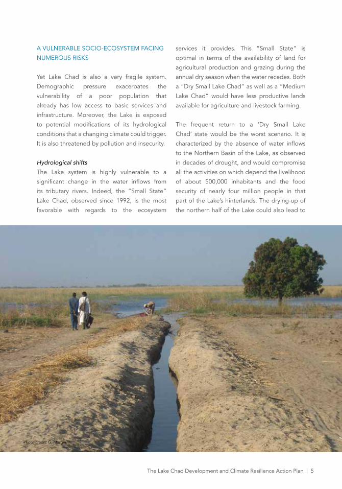
A VULNERABLE SOCIO-ECOSYSTEM FACING
NUMEROUS RISKS
Yet Lake Chad is also a very fragile system.
Demographic pressure exacerbates the
vulnerability of a poor population that
already has low access to basic services and
infrastructure. Moreover, the Lake is exposed
to potential modifications of its hydrological
conditions that a changing climate could trigger.
It is also threatened by pollution and insecurity.
Hydrological shifts
The Lake system is highly vulnerable to a
significant change in the water inflows from
its tributary rivers. Indeed, the “Small State”
Lake Chad, observed since 1992, is the most
favorable with regards to the ecosystem
services it provides. This “Small State” is
optimal in terms of the availability of land for
agricultural production and grazing during the
annual dry season when the water recedes. Both
a “Dry Small Lake Chad” as well as a “Medium
Lake Chad” would have less productive lands
available for agriculture and livestock farming.
The frequent return to a ‘Dry Small Lake
Chad’ state would be the worst scenario. It is
characterized by the absence of water inflows
to the Northern Basin of the Lake, as observed
in decades of drought, and would compromise
all the activities on which depend the livelihood
of about 500,000 inhabitants and the food
security of nearly four million people in that
part of the Lake’s hinterlands. The drying-up of
the northern half of the Lake could also lead to
Photo credit: G. Margin
6 | The Lake Chad Development and Climate Resilience Action Plan
migration to its southern shores, intensifying
pressure on resources for agriculture, fishing,
and livestock farming in the rest of the lake
area and resulting in conflicts. This transition
to a “Dry Small Lake Chad” could result from a
decrease in precipitation due to climate change
or to a significant increase in water withdrawals
from the rivers feeding the Lake, mainly from the
Chari-Logone River.
Pollution risks
Due to its very shallow depth and the prevalence
of wetlands, the Lake system is highly
vulnerable to pollution. Yet the exploitation of
hydrocarbons is expanding in the basin and the
Lake itself, and the inadequate use of pesticides
in agriculture may already have an impact on
animal health (ruminants and fish). Untreated
municipal wastewater and industrial and mining
effluents are also a risk.
Low Human Development Index and levels of
basic services and infrastructure
The human development indicators for the
Lake Chad area are far lower than national
averages, which themselves are low compared to
international standards. The area generally lacks
basic public social services and infrastructure such
as education, health, water, roads, and electricity.
(Lemoalle and Magrin, 2014; Magrin et al., 2015).
One of the highest population growth rates in
the world
The Lake Chad Basin is experiencing one of the
highest rates of population growth in the world
which could heighten risks related to the over-
exploitation of natural resources and to socio-
political instability, especially if not enough jobs
are created to provide a living for a growing
number of young adults. This demographic
pressure will also make even more pressing the
need to improve basic services and infrastructure.
Insecurity
In 2014 and 2015, the Lake Chad region was
struck by extensive violence, associated with the
Boko Haram movement, particularly in the whole
of northeastern Nigeria as well as in the border
areas of Niger, Cameroon, and Chad. Tens of
thousands of people have been displaced.
Trade has been disrupted and the regional
economy destabilized. These challenges
have strengthened the integrative dynamics
developed in recent years between the States
bordering the lake: border agreements, joint
mobilization and solidarity to restore security,
and joint projects. This cooperation is now
expected to become more concrete and
effective in the field of economic development,
including in particular the proposed Action Plan.
Information Gaps and Climate Uncertainties Make the Management of the Lake Socio-ecosystem More Complex
The population in the Lake’s basin will double
over the next 30 years, likely causing an increase
in water withdrawals for human consumption,
irrigation, and industries. Yet, according to
models from the Intergovernmental Panel
on Climate Change (IPPC), future changes
in precipitation in this part of the world
are unknown. Moreover, information on
groundwater, water withdrawals, sedimentation
in the Lake and the rivers feeding it, as well as
the functioning of floodplains is inadequate. In
this context, the management of the Lake will
need to: (a) prioritize “no regret investments
and policies” which will be beneficial in all
scenarios, and (b) improve the knowledge base
to reduce uncertainty and refine feasibility
studies before engaging in costly, large-scale,
high-risk infrastructure development.
6 | The Lake Chad Development and Climate Resilience Action Plan The Lake Chad Development and Climate Resilience Action Plan | 7
A Ten-year Multi-sectoral Development and Climate Resilience Action Plan to Turn Lake Chad into a Pole of Regional Rural Development
In order to respond to these challenges, LCBC
and its member States, with support from the
World Bank Group and in coordination with the
French Development Agency/Agence Française
de Development (AFD), have prepared the Lake
Chad Development and Climate Resilience
Action Plan (LCDAP) for the period of 2016-
2025. The core idea of the Plan is that, in parallel
to the restoration of peace and security, there is
a need to turn Lake Chad into a pole of regional
rural development. This objective is in line with
LCBC strategic planning documents developed
by LCBC during the past years, including the
Vision 2025, the Strategic Action Plan, and the
Water Charter.
To meet its objectives, the Plan intends to contribute
significantly to food security, employment, and
the social inclusion of youth by improving, in
a sustainable way: (a) the living conditions of
populations settled on the Lake’s banks and islands,
and (b) the resilience of a system characterized by
strong demographic growth, high hydrological
variability, and climate uncertainty.
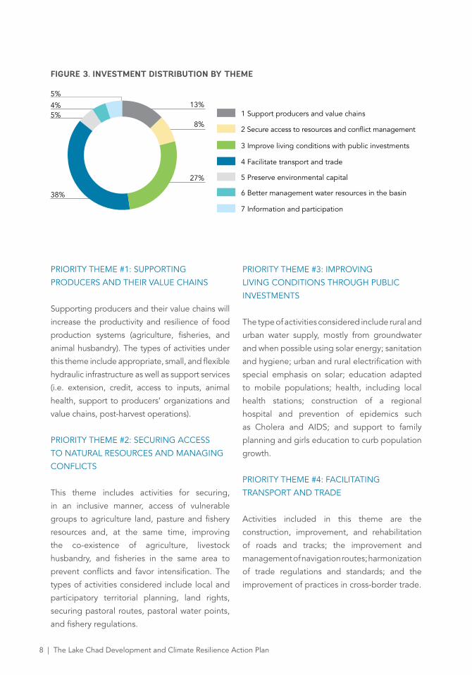
Seven Priority Themes
The LCDAP proposes a total of seven priority
themes, grouping a total of 173 activities (see
Figure 3) summarized below. Some of the
projects and measures included in the present
Action Plan come from LCBC’s five-year
investment plan (2013-2017) and its Emergency
Program for youth and vulnerable groups in the
region of Lake Chad (PURDEP) 2015-2016, as
well as recent national planning documents for
at least part of Lake Chad. Others, not identified
in those documents, have been included in the
Action Plan in order to meet its stated objective
for a ten-year planning horizon.
Photo credit: G. Margin
8 | The Lake Chad Development and Climate Resilience Action Plan
7 Information and participation
6 Better management water resources in the basin
5 Preserve environmental capital
4 Facilitate transport and trade
3 Improve living conditions with public investments
2 Secure access to resources and conflict management
1 Support producers and value chains
5%
5%8%
13%
38%
27%
4%
FIGURE 3. INVESTMENT DISTRIBUTION BY THEME
PRIORITY THEME #1: SUPPORTING
PRODUCERS AND THEIR VALUE CHAINS
Supporting producers and their value chains will
increase the productivity and resilience of food
production systems (agriculture, fisheries, and
animal husbandry). The types of activities under
this theme include appropriate, small, and flexible
hydraulic infrastructure as well as support services
(i.e. extension, credit, access to inputs, animal
health, support to producers’ organizations and
value chains, post-harvest operations).
PRIORITY THEME #2: SECURING ACCESS
TO NATURAL RESOURCES AND MANAGING
CONFLICTS
This theme includes activities for securing,
in an inclusive manner, access of vulnerable
groups to agriculture land, pasture and fishery
resources and, at the same time, improving
the co-existence of agriculture, livestock
husbandry, and fisheries in the same area to
prevent conflicts and favor intensification. The
types of activities considered include local and
participatory territorial planning, land rights,
securing pastoral routes, pastoral water points,
and fishery regulations.
PRIORITY THEME #3: IMPROVING
LIVING CONDITIONS THROUGH PUBLIC
INVESTMENTS
The type of activities considered include rural and
urban water supply, mostly from groundwater
and when possible using solar energy; sanitation
and hygiene; urban and rural electrification with
special emphasis on solar; education adapted
to mobile populations; health, including local
health stations; construction of a regional
hospital and prevention of epidemics such
as Cholera and AIDS; and support to family
planning and girls education to curb population
growth.
PRIORITY THEME #4: FACILITATING
TRANSPORT AND TRADE
Activities included in this theme are the
construction, improvement, and rehabilitation
of roads and tracks; the improvement and
management of navigation routes; harmonization
of trade regulations and standards; and the
improvement of practices in cross-border trade.
8 | The Lake Chad Development and Climate Resilience Action Plan The Lake Chad Development and Climate Resilience Action Plan | 9
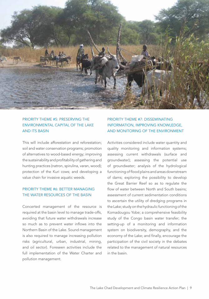
PRIORITY THEME #5: PRESERVING THE
ENVIRONMENTAL CAPITAL OF THE LAKE
AND ITS BASIN
This will include afforestation and reforestation;
soil and water conservation programs; promotion
of alternatives to wood-based energy; improving
the sustainability and profitability of gathering and
hunting practices (natron, spirulina, varan, wood);
protection of the Kuri cows; and developing a
value chain for invasive aquatic weeds.
PRIORITY THEME #6: BETTER MANAGING
THE WATER RESOURCES OF THE BASIN
Concerted management of the resource is
required at the basin level to manage trade-offs,
avoiding that future water withdrawals increase
so much as to prevent water inflows into the
Northern Basin of the Lake. Sound management
is also required to manage increasing pollution
risks (agricultural, urban, industrial, mining,
and oil sector). Foreseen activities include the
full implementation of the Water Charter and
pollution management.
PRIORITY THEME #7: DISSEMINATING
INFORMATION, IMPROVING KNOWLEDGE,
AND MONITORING OF THE ENVIRONMENT
Activities considered include water quantity and
quality monitoring and information systems;
assessing current withdrawals (surface and
groundwater); assessing the potential use
of groundwater; analysis of the hydrological
functioning of flood plains and areas downstream
of dams; exploring the possibility to develop
the Great Barrier Reef so as to regulate the
flow of water between North and South basins;
assessment of current sedimentation conditions
to ascertain the utility of dredging programs in
the Lake; study on the hydraulic functioning of the
Komadougou Yobe; a comprehensive feasibility
study of the Congo basin water transfer; the
setting-up of a monitoring and information
system on biodiversity, demography, and the
economy of the Lake; and finally, encourage the
participation of the civil society in the debates
related to the management of natural resources
in the basin.
Photo credit: G. Margin
10 | The Lake Chad Development and Climate Resilience Action Plan
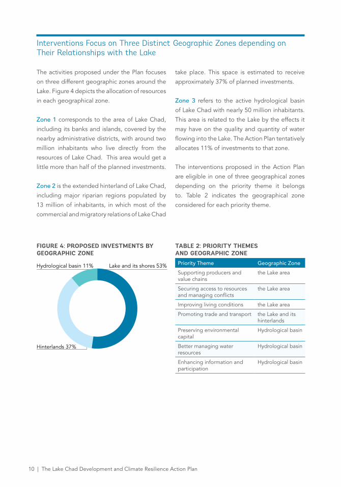
FIGURE 4: PROPOSED INVESTMENTS BY GEOGRAPHIC ZONE
TABLE 2: PRIORITY THEMES AND GEOGRAPHIC ZONEPriority Theme Geographic Zone
Supporting producers and value chains
the Lake area
Securing access to resources and managing conflicts
the Lake area
Improving living conditions the Lake area
Promoting trade and transport the Lake and its hinterlands
Preserving environmental capital
Hydrological basin
Better managing water resources
Hydrological basin
Enhancing information and participation
Hydrological basin
Lake and its shores 53%
Hinterlands 37%
Hydrological basin 11%
Interventions Focus on Three Distinct Geographic Zones depending on Their Relationships with the Lake
The activities proposed under the Plan focuses
on three different geographic zones around the
Lake. Figure 4 depicts the allocation of resources
in each geographical zone.
Zone 1 corresponds to the area of Lake Chad,
including its banks and islands, covered by the
nearby administrative districts, with around two
million inhabitants who live directly from the
resources of Lake Chad. This area would get a
little more than half of the planned investments.
Zone 2 is the extended hinterland of Lake Chad,
including major riparian regions populated by
13 million of inhabitants, in which most of the
commercial and migratory relations of Lake Chad
take place. This space is estimated to receive
approximately 37% of planned investments.
Zone 3 refers to the active hydrological basin
of Lake Chad with nearly 50 million inhabitants.
This area is related to the Lake by the effects it
may have on the quality and quantity of water
flowing into the Lake. The Action Plan tentatively
allocates 11% of investments to that zone.
The interventions proposed in the Action Plan
are eligible in one of three geographical zones
depending on the priority theme it belongs
to. Table 2 indicates the geographical zone
considered for each priority theme.
10 | The Lake Chad Development and Climate Resilience Action Plan The Lake Chad Development and Climate Resilience Action Plan | 11
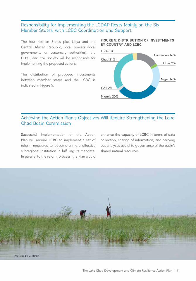
Responsibility for Implementing the LCDAP Rests Mainly on the Six Member States, with LCBC Coordination and Support
The four riparian States plus Libya and the
Central African Republic, local powers (local
governments or customary authorities), the
LCBC, and civil society will be responsible for
implementing the proposed actions.
The distribution of proposed investments
between member states and the LCBC is
indicated in Figure 5.
FIGURE 5: DISTRIBUTION OF INVESTMENTS BY COUNTRY AND LCBC
Achieving the Action Plan’s Objectives Will Require Strengthening the Lake Chad Basin Commission
Successful implementation of the Action
Plan will require LCBC to implement a set of
reform measures to become a more effective
subregional institution in fulfilling its mandate.
In parallel to the reform process, the Plan would
enhance the capacity of LCBC in terms of data
collection, sharing of information, and carrying
out analyses useful to governance of the basin’s
shared natural resources.
Libya 2%
Niger 16%
Nigeria 30%
CAR 2%
Chad 31%
LCBC 3%Cameroon 16%
Photo credit: G. Margin
12 | The Lake Chad Development and Climate Resilience Action Plan
References
Magrin G., Pourtier R., Lemoalle J. (dir.), 2015.
Atlas du lac Tchad, Paris, Passages, République
du Tchad, AFD, IRD, 227p.
Lemoalle J., Magrin G. (dir.), 2014. Le
développement du lac Tchad : situation
actuelle et futurs possibles, CBLT, Marseille,
IRD-Editions, coll. Expertise collégiale bilingue
français-anglais, 216p. + clé USB (contributions
intégrales des experts : 638p.)
The 5-year investment plan, LCBC, 2014.
The Priority Development Emergency Program
for youth and vulnerable people in Lake Chad
(PURDEP), LCBC, 2015.
This document has benefited from Passages-
ADAPes cooperation for the reproduction of
maps from « Atlas du lac Tchad » (2015).

12 | The Lake Chad Development and Climate Resilience Action Plan
Recommended