Embed Size (px)
Citation preview
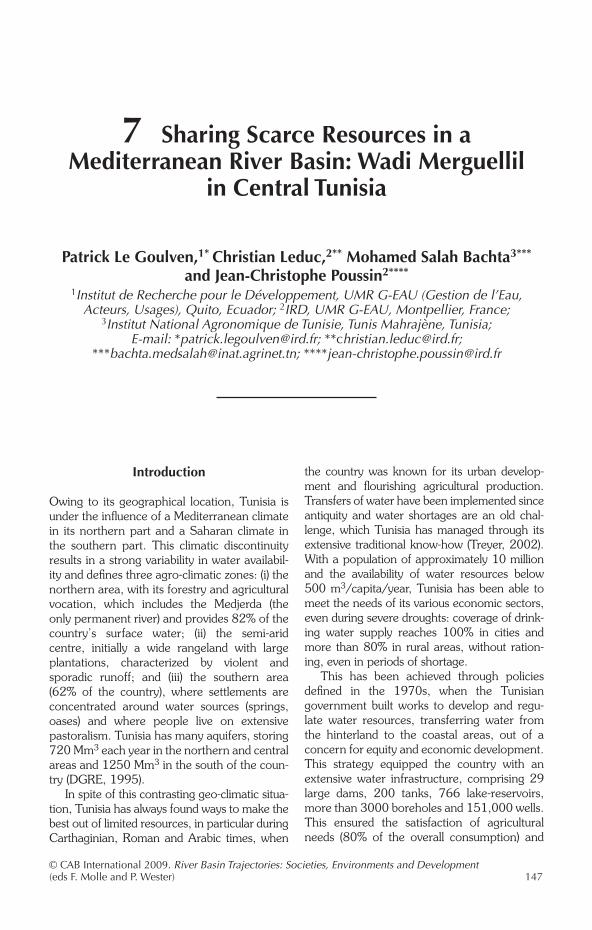
7 Sharing Scarce Resources in a Mediterranean River Basin: Wadi Merguellil
in Central Tunisia
Patrick Le Goulven,1* Christian Leduc,2** Mohamed Salah Bachta3*** and Jean-Christophe Poussin2****
1Institut de Recherche pour le Développement, UMR G-EAU (Gestion de l’Eau, Acteurs, Usages), Quito, Ecuador; 2IRD, UMR G-EAU, Montpellier, France;
3Institut National Agronomique de Tunisie, Tunis Mahrajène, Tunisia; E-mail: *[email protected]; **[email protected];
***[email protected]; ****[email protected]
Introduction
Owing to its geographical location, Tunisia is under the influence of a Mediterranean climate in its northern part and a Saharan climate in the southern part. This climatic discontinuity results in a strong variability in water availabil-ity and defines three agro-climatic zones: (i) the northern area, with its forestry and agricultural vocation, which includes the Medjerda (the only permanent river) and provides 82% of the country’s surface water; (ii) the semi-arid centre, initially a wide rangeland with large plantations, characterized by violent and sporadic runoff; and (iii) the southern area (62% of the country), where settlements are concentrated around water sources (springs, oases) and where people live on extensive pastoralism. Tunisia has many aquifers, storing 720 Mm3 each year in the northern and central areas and 1250 Mm3 in the south of the coun-try (DGRE, 1995).
In spite of this contrasting geo-climatic situa-tion, Tunisia has always found ways to make the best out of limited resources, in particular during Carthaginian, Roman and Arabic times, when
the country was known for its urban develop-ment and flourishing agricultural production. Transfers of water have been implemented since antiquity and water shortages are an old chal-lenge, which Tunisia has managed through its extensive traditional know-how (Treyer, 2002). With a population of approximately 10 million and the availability of water resources below 500 m3/capita/year, Tunisia has been able to meet the needs of its various economic sectors, even during severe droughts: coverage of drink-ing water supply reaches 100% in cities and more than 80% in rural areas, without ration-ing, even in periods of shortage.
This has been achieved through policies defined in the 1970s, when the Tunisian government built works to develop and regu-late water resources, transferring water from the hinterland to the coastal areas, out of a concern for equity and economic development. This strategy equipped the country with an extensive water infrastructure, comprising 29 large dams, 200 tanks, 766 lake-reservoirs, more than 3000 boreholes and 151,000 wells. This ensured the satisfaction of agricultural needs (80% of the overall consumption) and
© CAB International 2009. River Basin Trajectories: Societies, Environments and Development (eds F. Molle and P. Wester) 147
148 P. Le Goulven et al.
allowed the development of mass tourism along the coast, an activity characterized by a seasonal demand for good-quality water.
The central area has not been directly impacted by the growth of tourism but it has undergone changes through its relationship with the coastal area (called the ‘Sahel’) in terms of labour migration, water transfers and emergence of new markets for agricultural produce. Kairouan, the main town in this area, is located above an aquifer which collects the water of three river basins (Zeroud, Merguellil, Nebhana) draining the Tunisian central high-lands. These basins were first closed by dams (constructed between 1965 and 1989) designed to protect Kairouan from exceptional floods. The Merguellil basin was also the target of vari-ous soil and water conservation works from the 1960s onwards, which formed a part of succes-sive regional development plans and water resources management policies. However, water users and other stakeholders played a very small part in these strategies – which were planned and implemented by the central administration – and these are nowadays increasingly questioned and challenged.
The Merguellil basin provides an ideal case study to analyse the effect of the progressive establishment of water infrastructure, its use by various segments of the population and their impact on the spatial and social distribution of water resources. In spite of costly investments, the water tables of the aquifers of the upper basin and of the Kairouan plain are dropping at an increasing rate. The Merguellil basin also provides the opportunity to examine the modes of governance, as well as the economic and regulatory tools which might assist in the control of access to water resources.
Characteristics of the Merguellil Basin
Environmental context
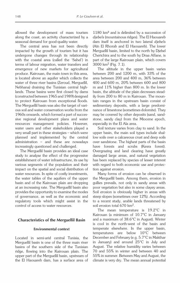
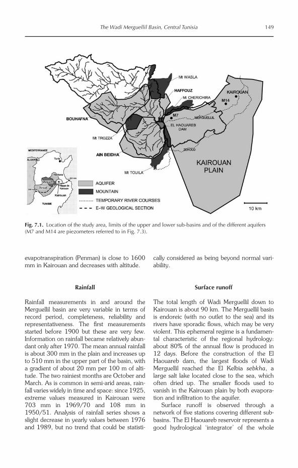
Located in semi-arid central Tunisia, the Merguellil basin is one of the three main river basins of the southern side of the Tunisian ridge, flowing into the Kairouan plain. The upper part of the Merguellil basin, upstream of the El Haouareb dam, has a surface area of
1180 km² and is delimited by a succession of djebels (mountainous ridges). The El Haouareb dam itself is anchored in two lateral djebels (Aïn El Rhorab and El Haouareb). The lower Merguellil basin, limited to the north by Djebel Cherichira and to the south by Draa Affane, is part of the large Kairouan plain, which covers 3000 km2 (Fig. 7.1).
The altitude in the upper basin varies between 200 and 1200 m, with 33% of the area between 200 and 400 m, 36% between 400 and 600 m, 20% between 600 and 800 m and 11% higher than 800 m. In the lower basin, the altitude of the plain decreases stead-ily from 200 to 80 m in Kairouan. The moun-tain ranges in the upstream basin consist of sedimentary deposits, with a large predomi-nance of limestone (sometimes dolomite). They may be covered by other deposits (sand, sand-stone, sandy clay) from the Miocene epoch, especially in the El Ala area.
Soil texture varies from clay to sand. In the upper basin, the main soil types include shal-low soils over a calcareous crust and deep soils over sandstone. The highest parts of the basin have forests and scrubs (Kesra forest). Overgrazing and land clearing have greatly damaged large areas, and natural vegetation has been replaced by species of lesser interest with regard to both economic use and protec-tion against erosion.
Many forms of erosion can be observed in the Merguellil basin. Among them, erosion in gullies prevails, not only in sandy areas with poor vegetation but also in some clayey areas. Soil erosion is obviously higher in areas with steep slopes (sometimes over 12%). According to a recent study, arable lands threatened by soil erosion total 670 km2.
The mean temperature is 19.2°C in Kairouan (a minimum of 10.7°C in January and a maximum of 38.6°C in August). Winter is cool in the north-west of the basin and temperate elsewhere. In the upper basin, temperatures are below 10°C between December and February (e.g. 5.7°C in Makthar in January) and around 25°C in July and August. The relative humidity varies between 70 and 55% in winter and between 40 and 55% in summer. Between May and August, the climate is very dry. The mean annual potential
The Wadi Merguellil Basin, Central Tunisia 149
evapotranspiration (Penman) is close to 1600 mm in Kairouan and decreases with altitude.
Rainfall
Rainfall measurements in and around the Merguellil basin are very variable in terms of record period, completeness, reliability and representativeness. The first measurements started before 1900 but these are very few. Information on rainfall became relatively abun-dant only after 1970. The mean annual rainfall is about 300 mm in the plain and increases up to 510 mm in the upper part of the basin, with a gradient of about 20 mm per 100 m of alti-tude. The two rainiest months are October and March. As is common in semi-arid areas, rain-fall varies widely in time and space: since 1925, extreme values measured in Kairouan were 703 mm in 1969/70 and 108 mm in 1950/51. Analysis of rainfall series shows a slight decrease in yearly values between 1976 and 1989, but no trend that could be statisti-
cally considered as being beyond normal vari-ability.
Surface runoff
The total length of Wadi Merguellil down to Kairouan is about 90 km. The Merguellil basin is endoreic (with no outlet to the sea) and its rivers have sporadic flows, which may be very violent. This ephemeral regime is a fundamen-tal characteristic of the regional hydrology: about 80% of the annual flow is produced in 12 days. Before the construction of the El Haouareb dam, the largest floods of Wadi Merguellil reached the El Kelbia sebkha, a large salt lake located close to the sea, which often dried up. The smaller floods used to vanish in the Kairouan plain by both evapora-tion and infiltration to the aquifer.
Surface runoff is observed through a network of five stations covering different sub-basins. The El Haouareb reservoir represents a good hydrological ‘integrator’ of the whole
Fig. 7.1. Location of the study area, limits of the upper and lower sub-basins and of the different aquifers (M7 and M14 are piezometers referred to in Fig. 7.3).
150 P. Le Goulven et al.
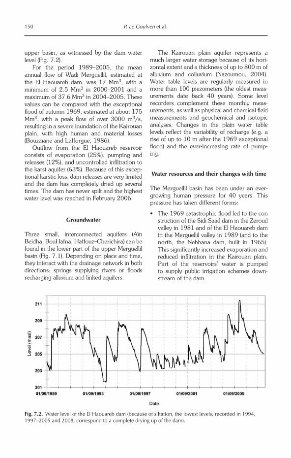
upper basin, as witnessed by the dam water level (Fig. 7.2).
For the period 1989–2005, the mean annual flow of Wadi Merguellil, estimated at the El Haouareb dam, was 17 Mm3, with a minimum of 2.5 Mm3 in 2000–2001 and a maximum of 37.6 Mm3 in 2004–2005. These values can be compared with the exceptional flood of autumn 1969, estimated at about 175 Mm3, with a peak flow of over 3000 m3/s, resulting in a severe inundation of the Kairouan plain, with high human and material losses (Bouzaïane and Lafforgue, 1986).
Outflow from the El Haouareb reservoir consists of evaporation (25%), pumping and releases (12%), and uncontrolled infiltration to the karst aquifer (63%). Because of this excep-tional karstic loss, dam releases are very limited and the dam has completely dried up several times. The dam has never spilt and the highest water level was reached in February 2006.
Groundwater
Three small, interconnected aquifers (Aïn Beidha, BouHafna, Haffouz–Cherichira) can be found in the lower part of the upper Merguellil basin (Fig. 7.1). Depending on place and time, they interact with the drainage network in both directions: springs supplying rivers or floods recharging alluvium and linked aquifers.
The Kairouan plain aquifer represents a much larger water storage because of its hori-zontal extent and a thickness of up to 800 m of alluvium and colluvium (Nazoumou, 2004). Water table levels are regularly measured in more than 100 piezometers (the oldest meas-urements date back 40 years). Some level recorders complement these monthly meas-urements, as well as physical and chemical field measurements and geochemical and isotopic analyses. Changes in the plain water table levels reflect the variability of recharge (e.g. a rise of up to 10 m after the 1969 exceptional flood) and the ever-increasing rate of pump-ing.
Water resources and their changes with time
The Merguellil basin has been under an ever-growing human pressure for 40 years. This pressure has taken different forms:
• The1969catastrophicfloodledtotheconstruction of the Sidi Saad dam in the Zeroud valley in 1981 and of the El Haouareb dam in the Merguellil valley in 1989 (and to the north, the Nebhana dam, built in 1965). This significantly increased evaporation and reduced infiltration in the Kairouan plain. Part of the reservoirs’ water is pumped to supply public irrigation schemes down-stream of the dam.
Fig. 7.2. Water level of the El Haouareb dam (because of siltation, the lowest levels, recorded in 1994, 1997–2005 and 2008, correspond to a complete drying up of the dam).
The Wadi Merguellil Basin, Central Tunisia 151
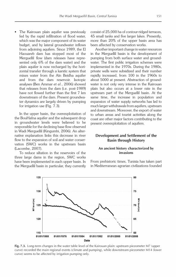
• TheKairouanplain aquiferwas previouslyfed by the rapid infiltration of flood water, which was the major component of its water budget, and by lateral groundwater inflows from adjoining aquifers. Since 1989, the El Haouareb dam has stopped most of the Merguellil flow (dam releases have repre-sented only 6% of the dam water) and the plain aquifer is now recharged by the hori-zontal transfer through a karstic system that mixes water from the Aïn Beidha aquifer and from the dam reservoir. Isotopic ana lyses (Ben Ammar et al., 2006) showed that releases from the dam (i.e. post-1989) have not flowed further than the first 7 km downstream of the dam. Present groundwa-ter dynamics are largely driven by pumping for irrigation use (Fig. 7.3).
In the upper basin, the overexploitation of the BouHafna aquifer and the subsequent drop in groundwater levels were believed to be responsible for the declining base flow observed in Wadi Merguellil (Kingumbi, 2006). An alter-native explanation links this decrease in river flow to the expansion of soil and water conser-vation (SWC) works in the upstream basin (Lacombe, 2007).
To reduce siltation in the reservoirs of the three large dams in the region, SWC works have been implemented in each upper basin. In the Merguellil basin in particular, they currently
consist of 25,000 ha of contour-ridged terraces, 45 small tanks and five larger lakes. Presently, more than 20% of the upper basin area has been affected by conservation works.
Another important change in water resources in the Merguellil basin is the development of pumping from both surface water and ground-water. The first public irrigation schemes were implemented in the 1970s. During the 1980s, private wells were subsidized and their number rapidly increased, from 100 in the 1960s to about 5000 at present. Abstraction of ground-water is not only very intense in the Kairouan plain but also occurs at a lower rate in the upstream part of the Merguellil basin. At the same time, the increase in population and expansion of water supply networks has led to much larger withdrawals from aquifers, upstream and downstream. Moreover, the export of water to urban areas and tourist activities along the coast are other major factors contributing to the present overexploitation of aquifers.
Development and Settlement of the Basin through History
An ancient history characterized by invasions
From prehistoric times, Tunisia has taken part in Mediterranean agrarian civilizations founded
Fig. 7.3. Long-term changes in the water table level of the Kairouan plain: upstream piezometer M7 (upper curve) recorded the main regional events (climate and pumping), while downstream piezometer M14 (lower curve) seems to be affected by irrigation pumping only.
152 P. Le Goulven et al.
on cereals (maize, barley) and small cattle (small ox, grey donkey, sheep). The common olive tree and the carob tree were known by the first inhabitants of the country, the Berbers, along with the wild vine, the fig tree and the almond tree, which are thought to be indigenous species. But it was the Phoenician coloniza-tion, around 800 bc, which brought the tech-niques of arboriculture, and multiplied orchards and gardens, as testified by the famous treatise written by Magon during the 3rd century bc.
Rome colonized the northern part of Tunisia in 146 bc, and the centre and the south later on. Its presence until the 5th century ad led to a refining of Carthaginian farming techniques and the development of very sophisticated irri-gation schemes (Géroudet, 2004a). Tunisian maize and olive oil were essential condiments in Roman food. In the same way, the tech-niques of breeding and craft industry devel-oped: the orange-red, sigillated ceramics produced in the heart of the area were found in the whole Mediterranean basin as of the end of 2nd century ad.
In the Merguellil region, Romans populated the mountainous zones in particular (Kesra, Makthar, El Alaa, Djebel Ousselet) and devel-oped olive trees. They were grown at higher altitudes, in sandy soils, with low densities (five to six trees/ha) and were surrounded by small, low walls to ensure good water supply (Géroudet, 2004a). The Romans had a good command of many hydraulic techniques and constructed many cisterns, tanks and aque-ducts. Nowadays, farmers still collect the fruits of ‘Roman olive trees’.
Between the fall of the Roman and Byzantine empires and the French coloniza-tion, the countryside was regularly plundered by successive invasions by tribes coming from Arabia (in particular starting from the 7th century), and from the south of Egypt (Beni Hillel in 1051). This latter tribe devastated the south and the heart of the country, destroyed the city of Kairouan and the countryside – cutting down part of the old Roman olive trees – and destroyed water-harvesting structures. Fertile areas were thus abandoned and seden-tary populations hid in the mountains: livestock breeding replaced agriculture. There was no notable improvement of agriculture under the Ottoman Empire, when the heavy taxes
imposed on peasants limited agricultural devel-opment (Géroudet, 2004b).
Founded in 670 ad by Oqba Ibn Nafaa, the city of Kairouan is located on a rich alluvial plain and close to a sebkha, which was used as a water reserve and pasture for the horses and camels of armies. One century later, the city was connected by underground conduits to large reservoirs located a few kilometres apart (Qsar Al Mâ) and supplied by neighbouring wadis (Mahfoudh et al., 2004). The Aghlabides (800–909 ad) enlarged these reservoirs, and Kairouan was, by then, the intellectual and political centre of the Maghreb.
Spatial settlement during the 18th and 19th centuries
Historical records from the 18th century reveal a tribe-based society where individuals only exist as a member of a tribe. The history of its founder, of his migrations and then of his descendants belongs to the history of the tribe and makes it possible to legitimize the occupa-tion of a particular piece of land. The exten-sion of the territory occupied by these tribes was not measured and natural topographic elements provided only landmarks. Boundaries were social: the territory of the tribe ended where that of another tribe started. Certain tribes have an affiliation to a marabout (religious leader); others have neither a founder nor a history of migration and this is the case with the Berber tribes.
Livelihoods combined a concentration of agricultural production on limited areas where water was accessible with an extensive exploi-tation of dispersed pastoral resources (Genin et al., 2006). Rangelands were collective and croplands were at the disposal of all, protected against foreign invasions by the whole tribe. Rules for cultivated land, gardens and water use varied according to groups and natural conditions. Since Roman times the local popu-lation has acquired a good technical know-how concerning the control of stream flows and the enhancing of infiltration using small-scale land and water conservation works.
In such a contrasting environment, the inventoried techniques are very diverse: benches (tabias) and field terraces on sloppy
The Wadi Merguellil Basin, Central Tunisia 153
land, works in the wadis to slow down the flow (jessours), small tanks to store water in summer, canals to divert and spread flood flow (mgoud), water collectors with controlled and directed flow (meskat), groundwater tapping, and distri-bution by irrigation channels or seguias.
The rudimentary aspect of these works was compensated for by a sophisticated social management of water based on the seguia, which is used as a dividing, conveyance and final distribution channel, regulated by elabo-rate and precise customary rights. The same social group selected the site and the charac-teristics of the works, and organized their maintenance and their exploitation.
Conditions of access to water structured these rural tribes into groups of owners (water and land), and beneficiaries without property rights and generally marginalized, who pro-vided labour for construction, maintenance and man age ment of these infrastructures. The cohabitation of these two social groups was defined by a set of rules referring to water prop-erty, its distribution and maintenance of the works. These rules were accepted by all and specified the statutes and the roles of each indi-vidual in the tribe. Even if water often remained ‘the friend of the powerful’ (Bedoucha, 1987), there was a coherence between technical tools and management goals, which ensured the overall performance of the system.
French protectorate (1881–1956) and evolution of societies
More centred on the north and the Sahel, the French presence in the Merguellil area was limited to only two large properties: the El Haouareb farm (3700 ha) and the Ousseltia-Pichon farm (8000 ha). Their contribution remained technical in nature, with the develop-ment of strictly rainfed arboriculture. However, colonization modified the basin landscape, as tractors and modern ploughs partially destroyed the fesguias,1 the seguias, the terraces and the small stone-wall reservoirs which obstructed passage, thus increasing erosion.
Tribal structures changed little by little. Generalization of schooling made the prevail-ing social order anachronistic, with younger generations rarely agreeing to return to agricul-
tural work. Demographic growth caused strong pressure on natural resources, and successive intergenerational divisions resulted in strategies of both agricultural intensification and land expansion through clearing, with a consequent clear degradation of natural resources.
These external intrusions often came with radical technological innovations, which gener-ally remained the prerogative of certain classes within rural societies, leading to a form of dual-istic agriculture. This implied notable changes in the social relationships regarding property, access to resources and their exploitation towards productive ends. The reproduction of rural societies was affected by processes of adjustment and the end of a social model based on access to water governed by rules defined and enforced by local communities.
Independence and the development of large-scale hydraulics works
Post-independent Tunisia sought to structure space and sedentarize its population through the development of hydro-agricultural schemes. Collective decision making would be entrusted to the government and the administration, and would thus free individuals from the tribal struc-ture (Bachta et al., 2005; Bachta and Zaibet, 2006). The state built a large hydraulic infra-structure to capture, transfer and allocate water resources. This intervention can be broken down into three phases (Feuillette et al., 1998), followed by a period of reflection.
Technical investments
The construction of large infrastructural works was based on a logic of better distributing water resources between areas and of multiple uses in order to accelerate the development of the country, by increasing agricultural production in the northern area (considered as the ‘bread-basket of the country’), then by transferring the surplus towards coastal areas to feed the main centres of population, the tourist industry and key zones of high-value irrigated agriculture.
Legal and incentive measures
In parallel, authorities created legal regulations (the Water Code) which transformed the legal
154 P. Le Goulven et al.
status of the resource (public, inalienable and imprescriptible), established new rights of use and entrusted their implementation to the Ministry of Agriculture. Centralized institutions were created to implement national strategies at a regional level: sectoral general directo-rates, regional development offices, and a national company (SONEDE) for domestic water supply and sanitation (WS&S).
Technical investments were encouraged by incentives to intensify water use and by allow-ing easy and cheap access to the resource to priority uses: to ensure water supply and sani-tation to all, to stabilize rural incomes in order to limit rural outmigration, to ensure food secu-rity and to develop both export agriculture (citrus fruits) and tourism.
The economy phase
Mobilization of water resources slowed down because the cost of construction increased. Authorities strengthened regulation and state control (including the collection of fees) and also improved technical management of exist-ing hydraulics works (interconnections between works, multiple uses, optimization of alloca-tion). Water demand is high and diversified but there is yet no way of calling into question the use made of the resource. The difficulties encountered in the collection of operation and maintenance (O&M) fees in public irrigation schemes contributed to the extinction of the development offices in 1986 and to their replacement by the Regional Commission for Agricultural Development (CRDA) and local associations of collective interest (AIC) institu-tions, whose attributions were defined by amendments to the Water Code in 1987:
• AICs are endowedwith a legal status andare created on the initiative of the users or the administration. A yearly management agreement must be signed with the admin-istration. AICs cover the O&M costs of the hydraulic infrastructure put under their responsibility. The revenue comes from the contributions of the members, subsidies from the CRDA, and the sale of water.
• The CRDA is a structure created by the1989 decentralization law and established
at the level of the gouvernorat.2 It is a pluri-disciplinary structure composed of sections (arrondissements), which represent most national general directorates. Supervision of the AIC is one of the missions of the CRDA that receives the fees for the use of water. The water resources section is a water police, which establishes fines and lawsuits and transmits them to the police chief for processing by a civil jurisdiction.
Forthcoming shortages and ad hoc policies
At the end of the 1990s, various national stud-ies forecast a substantial discrepancy between water demand and water supply by around 2010. This led Tunisia to strengthen its control of water demand, using technical tools supported by complementary economic, legal and institutional measures:
• Pricing policy: the price of agricultural water doubled between 1989 and 1996. Pricing of domestic water follows a block-tariff, consumption by hotels being charged at the higher block level.
• Incentives for water savings: laws and decrees were promulgated to encour-age irrigators to save water; localized irri-gation was subsidized up to 60%; and the state rehabilitated infrastructure in public schemes.
• Reinforcement of collective management: AICs were turned into groups of collective interest (GIC), with extended roles and responsibilities. The authorities hoped to achieve financial disengagement and the collection of fees through the AICs.
• Small and medium hydraulic works: in 1995, the legislation on SWC defined vari-ous types of work to be implemented: tabias and vegetated benches on the top of the slopes to fight erosion and to increase water infiltration into the soil; short-lifespan tanks with no technical management to control siltation of larger dams (1000 planned, more than 400 built in 2000); larger tanks linked to human uses (203 planned, more than 100 completed); and water structures to infiltrate water or to spread flood water. These small works offer a better distribution and allocation of water
The Wadi Merguellil Basin, Central Tunisia 155
resources in the basin. They should increase storage capacity by using underground stor-age, slow down erosion and protect larger reservoirs by trapping part of the sediments. However, they decrease the flow to down-stream dams, and the management of the basin becomes more complex since it must integrate a whole set of superimposed water management schemes.
Impacts of public policies on the Merguellil basin
From 1956 to 1962, reafforestation works and construction of tabias were carried out to help solve unemployment problems. From 1962 to 1973, a development plan for the upper basin was designed under USAID auspices but its implementation – without local participation – was not a success. From 1974 to 1980, due to opposition from peasants, SWC works were carried out only on state land and forests.
In 1989, the El Haouareb dam was built, just before Wadi Merguellil reaches the Kairouan plain. This dam, oversized to protect Kairouan from extreme floods (such as that of
1969), supplies the El Haouareb irrigation scheme and recharges the downstream aquifer through continuous seepage. The rights to use the aquifer are assigned by the state, which established 15 public irrigation schemes supplied with groundwater wells as part of its policy to settle nomadic groups.
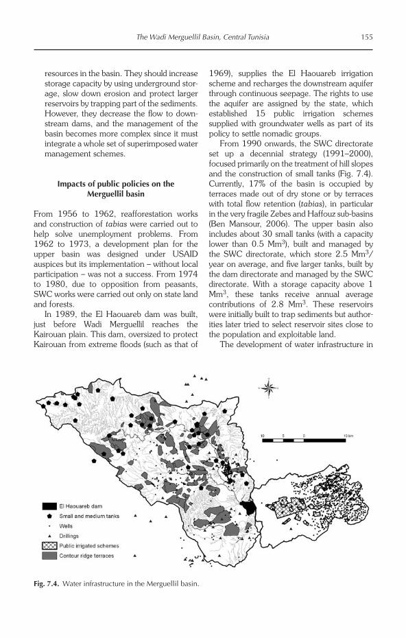
From 1990 onwards, the SWC directorate set up a decennial strategy (1991–2000), focused primarily on the treatment of hill slopes and the construction of small tanks (Fig. 7.4). Currently, 17% of the basin is occupied by terraces made out of dry stone or by terraces with total flow retention (tabias), in particular in the very fragile Zebes and Haffouz sub-basins (Ben Mansour, 2006). The upper basin also includes about 30 small tanks (with a capacity lower than 0.5 Mm3), built and managed by the SWC directorate, which store 2.5 Mm3/year on average, and five larger tanks, built by the dam directorate and managed by the SWC directorate. With a storage capacity above 1 Mm3, these tanks receive annual average contributions of 2.8 Mm3. These reservoirs were initially built to trap sediments but author-ities later tried to select reservoir sites close to the population and exploitable land.
The development of water infrastructure in
Fig. 7.4. Water infrastructure in the Merguellil basin.
156 P. Le Goulven et al.
the Merguellil basin illustrates the impact of successive public policies well, with the notable exception of groundwater wells, which have proliferated since 1974 in both upstream and downstream aquifers, despite official prohibi-tion. The wells are deepened by a local manual technique (forage à bras) as the water table drops, without intervention of the CRDA water police because authorities prefer to turn a blind eye to these practices and to encourage regional agricultural development.
Present Agriculture and Water Uses in the Merguellil Basin
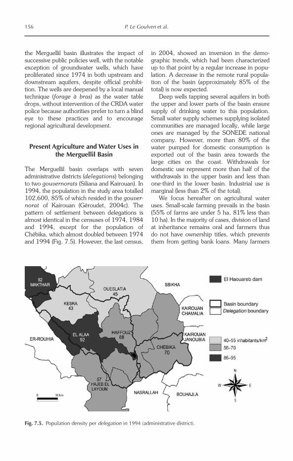
The Merguellil basin overlaps with seven administrative districts (delegations) belonging to two gouvernorats (Siliana and Kairouan). In 1994, the population in the study area totalled 102,600, 85% of which resided in the gouver-norat of Kairouan (Géroudet, 2004c). The pattern of settlement between delegations is almost identical in the censuses of 1974, 1984 and 1994, except for the population of Chébika, which almost doubled between 1974 and 1994 (Fig. 7.5). However, the last census,
in 2004, showed an inversion in the demo-graphic trends, which had been characterized up to that point by a regular increase in popu-lation. A decrease in the remote rural popula-tion of the basin (approximately 85% of the total) is now expected.
Deep wells tapping several aquifers in both the upper and lower parts of the basin ensure supply of drinking water to this population. Small water supply schemes supplying isolated communities are managed locally, while large ones are managed by the SONEDE national company. However, more than 80% of the water pumped for domestic consumption is exported out of the basin area towards the large cities on the coast. Withdrawals for domestic use represent more than half of the withdrawals in the upper basin and less than one-third in the lower basin. Industrial use is marginal (less than 2% of the total).
We focus hereafter on agricultural water uses. Small-scale farming prevails in the basin (55% of farms are under 5 ha, 81% less than 10 ha). In the majority of cases, division of land at inheritance remains oral and farmers thus do not have ownership titles, which prevents them from getting bank loans. Many farmers
Fig. 7.5. Population density per delegation in 1994 (administrative district).
The Wadi Merguellil Basin, Central Tunisia 157
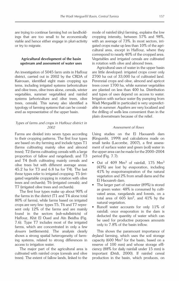
are trying to continue farming but on landhold-ings that are too small to be economically viable and hence either engage in pluri-activity or try to migrate.
Agricultural development of the basin upstream and assessment of water uses
An investigation of 5045 farm units in Haffouz district, carried out in 2002 by the CRDA of Kairouan, identified eight main cropping sys tems, including irrigated systems (arboriculture and olive trees, olive trees alone, cereals, winter vegetables, summer vegetables) and rainfed systems (arboriculture and olive trees, olive trees, cereals). This survey also identified a typology of farming systems that can be consid-ered as representative of the upper basin.
Types of farms and crops in Haffouz district in 2002
Farms are divided into seven types according to their cropping patterns. The first four types are based on dry farming and include types T1 (farms cultivating mainly olive and almond trees); T2 (farms cultivating cereals with a large proportion of fallow and rangeland); and T3 and T4 (both cultivating mainly cereals and olive trees but with different average areas: 45.2 ha for T3 and 6.8 ha for T4). The last three types refer to irrigated cropping: T5 (irri-gated vegetable cropping in rotation with olive trees and orchards); T6 (irrigated cereals); and T7 (irrigated olive trees and orchards).
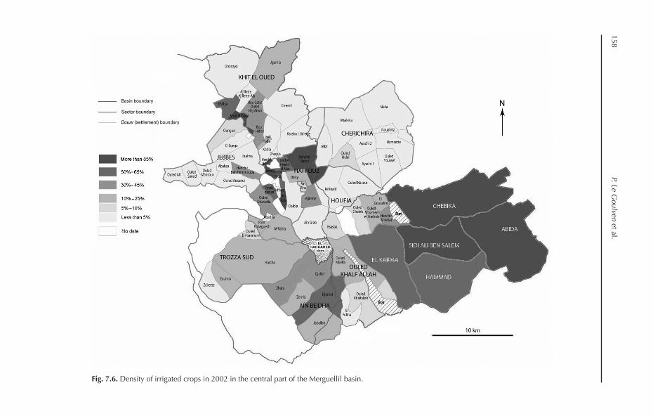
The first four types make up about 90% of the farms in the district (T1 and T4 alone total 80% of farms), while farms based on irrigated crops are very few: types T5, T6 and T7 repre-sent only 12% of the farms and are mainly found in the sectors (sub-subdistricts) of Haffouz, Khit El Oued and Aïn Beidha (Fig. 7.6). Type T7 includes most of the irrigated farms, which are concentrated in only a few douars (settlements). The analysis clearly shows a strong spatial heterogeneity of farm-ing systems, related to strong differences in access to irrigation water.
The major part of the agricultural area is cultivated with rainfed crops (cereals and olive trees). The extent of fallow lands, linked to the
mode of rainfed (dry) farming, explains the low cropping intensity, between 57% and 98%, with an average of 73%. In most sectors, irri-gated crops make up less than 10% of the agri-cultural area, except in Haffouz, where they correspond to nearly 40% of the cropped area. Vegetables and irrigated cereals are cultivated in rotation with olive and almond trees.
Agricultural uses of water in the upper basin are little developed: irrigated crops cover only 2700 ha out of 33,000 ha of cultivated land. Perennial crops and olive, almond and apricot trees cover 1700 ha, while summer vegetables are planted on less than 400 ha. Distribution and types of uses depend on access to water. Irrigation with surface water (by pumping from Wadi Merguellil in particular) is very unpredict-able in summer. Aquifers are very localized and the drilling of wells less convenient than in the plain downstream because of the relief.
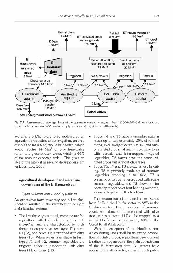
Assessment of flows
Using studies on the El Haouareb dam (Kingumbi, 1999) and calculations made on small tanks (Lacombe, 2007), a first assess-ment of surface water and green (soil) water in the upper area can be made for the 2000–2004 period (Fig. 7.7):
• Out of 409 Mm3 of rainfall, 175 Mm3 (43%) are lost by evaporation, including 41% by evapotranspiration of the natural vegetation and 2% from small dams and the El Haouareb dam.
• Thelargerpartofrainwater(89%)isstoredas green water: 48% is consumed by culti-vated areas, rangelands and forests, on a total area of 605 km2, and 41% by the natural vegetation.
• Runoff water accounts for only 11% ofrainfall; once evaporation in the dam is deducted the quantity of water which can be used for productive purposes amounts only to 7.8% of the basin inflow.
This shows the paramount importance of dryland farming, which uses the soil storage capacity (600 Mm3 for the basin, based on a reserve of 100 mm) and whose storage effi-ciency (88% for daily rainfall under 15 mm) is important (Dridi, 2000). If rainfed cereal production in the basin, which produces, on
158 P. Le G
oulven et al.
Fig. 7.6. Density of irrigated crops in 2002 in the central part of the Merguellil basin.
The Wadi Merguellil Basin, Central Tunisia 159
average, 2.6 t/ha, were to be replaced by an equivalent production under irrigation, an area of 6500 ha (at 4 t/ha) would be needed, which would require 14 Mm3 of blue (renewable runoff and groundwater) water, which is 44% of the amount exported today. This gives an idea of the interest in seeking drought-resistant varieties (Luc, 2005).
Agricultural development and water use downstream of the El Haouareb dam
Types of farms and cropping patterns
An exhaustive farm inventory and a first clas-sification resulted in the identification of eight main farming systems:
• Thefirstthreetypesmostlycombinerainfedagriculture with livestock (more than 1.5 sheep/ha) and are characterized by their dominant crops: olive trees (type T1), cere-als (T2), and cereals intercropped with olive trees (T3). When water is available in farm types T1 and T2, summer vegetables are irrigated either in association with olive trees (T1) or alone (T2).
• TypesT4andT6haveacroppingpatternmade up of approximately 20% of rainfed crops, exclusively of cereals in T4, and 80% of irrigated crops. T4 farms grow olive trees with cereals and intercropped irrigated vegetables; T6 farms have the same irri-gated crops but without olive trees.
• TypesT5,T7andT8areexclusivelyirrigat-ing. T5 is primarily made up of summer vegetables cropping in full field; T7 isprimarily olive trees intercropped with some summer vegetables, and T8 shows an im portant proportion of fruit-bearing orchards, alone or together with olive trees.
The proportion of irrigated crops varies from 24% in the Houfia sector to 88% in the Chebika sector. The proportion of summer vegetables, alone or intercropped with olive trees, varies between 11% of the cropped area in the Houfia sector and nearly 40% in the Ouled Khalf Allah sector.
With the exception of the Houfia sector, which distinguishes itself by its strong propor-tion of rainfed crops, agricultural development is rather homogeneous in the plain downstream of the El Harouareb dam. All sectors have access to irrigation water, either through public
Fig. 7.7. Assessment of average flows of the upstream zone of Merguellil basin (2000–2004) (E, evaporation; ET, evapotranspiration; WSS, water supply and sanitation; douars, settlements).
160 P. Le Goulven et al.
schemes or through private wells and boreholes pumping water from the Kairouan aquifer.
This results in a cropping pattern that includes 70% of irrigated crops, with 30% devoted to summer vegetables (melons, water-melons, peppers and tomatoes). This cultiva-tion of summer vegetables is the mainstay of irrigation development because it yields hand-some revenues. Its development is associated with the adoption of drip-irrigation, which is subsidized by the state at the level of 60% of capital costs for small farmers. This irrigation technique is also very labour saving, and asso-ciated fertigation allows farmers to strongly increase yields and therefore incomes.
Farmers can increase their areas cultivated with summer vegetables, but these crops are very risky and sensitive to market variations and vagaries. For example, prices of melons and watermelons are divided by three between
the first early productions and the main produc-tion season, approximately one month later.
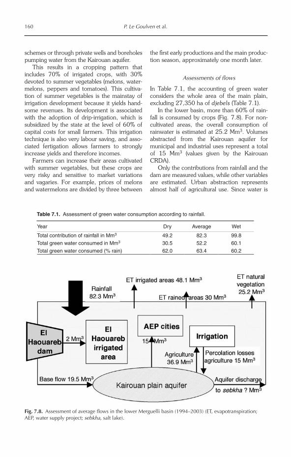
Assessments of flows
In Table 7.1, the accounting of green water considers the whole area of the main plain, excluding 27,350 ha of djebels (Table 7.1).
In the lower basin, more than 60% of rain-fall is consumed by crops (Fig. 7.8). For non-cultivated areas, the overall consumption of rainwater is estimated at 25.2 Mm3. Volumes abstracted from the Kairouan aquifer for municipal and industrial uses represent a total of 15 Mm3 (values given by the Kairouan CRDA).
Only the contributions from rainfall and the dam are measured values, while other variables are estimated. Urban abstraction represents almost half of agricultural use. Since water is
Table 7.1. Assessment of green water consumption according to rainfall.
Year Dry Average Wet
Total contribution of rainfall in Mm3 49.2 82.3 99.8
Total green water consumed in Mm3 30.5 52.2 60.1
Total green water consumed (% rain) 62.0 63.4 60.2
Fig. 7.8. Assessment of average flows in the lower Merguelli basin (1994–2003) (ET, evapotranspiration; AEP, water supply project; sebkha, salt lake).
The Wadi Merguellil Basin, Central Tunisia 161
exported and there is no return flow to the aquifer, this amounts to a net loss for the zone. The main inflow is rainfall and groundwater flows from the upper basin; the contribution of the dam through releases of surface water is very limited. Observations of aquifer levels confirm the imbalance between inflow and outflow and point to a shortfall of 17.4 Mm3, with agriculture as the main cause for this imbalance (net consumption of 21.9 Mm3) (Luc, 2005).
Competition for water between agriculture and other activities is very strong in the plain, but all sectors do not face the same constraints. Drinking water supply is a priority according to the Water Code, and abstraction is supposed to be done only through authorized and con trolled boreholes. Agricultural use in public schemes is also based on controlled ground-water abstraction, but the administration has, in fact, very little control over private wells. These wells are deepened in order to follow the decline of the aquifer and have spread out in the area, despite renewed prohibition. They came along with changes in agricultural prac-tices through the introduction of melons and watermelons, both of which ensure a hand-some income to farmers.
Assessment of flows in the entire basin
Most of the agricultural production in the upper basin is based on green water and its contribu-tion is also very substantial in the plain. In such a context, it is interesting to increase the volume of water stored in the ground and to make better use of it. For blue water at a global level, withdrawals for municipal and industrial use (27 Mm3) and irrigation (34 Mm3) are of the same order of magnitude and almost exclu-sively withdrawn from aquifers that are overex-ploited. The replacement of dryland farming by irrigated crops would jeopardize the balance of the aquifers and affect the export of drinking water to the Sahel zone.
Assessment of the lower basin is more complex. The aquifer drops but its functioning is poorly known. The basin being closed, with no natural outflow except the sebkha and the sea in case of extraordinary events, all the blue water available is currently mobilized and
depleted. To build further tanks and dams in the upper basin would be tantamount to a re-appropriation and redistribution of existing (and already used) resources. The only water which is not yet fully mobilized is green water. Because of farmers’ aversion to risk, produc-tion of dry farming is limited, even in wet years. Thus, substantial progress is possible by devel-oping crop varieties with better resistance to drought and stress and by improving cropping techniques, for example dry farming and mulching.
The very significant amount of water ex ported for domestic use induces a real competition for water and could place farmers in a difficult situation in case of shortages, since drinking water is a national priority.
Impacts and Valorization of Installations
After reviewing the status of main crops in the basin, we now turn to the assessment of the impact of water-harvesting structures in the upper basin. This is done through the compar-ison of the water flows before (1989–1996) and after (1997–2005) the implementation of SWC works.
Impacts of installations on the allocation of water
The analysis of runoff–rainfall relationships showed that the expansion of SWC infrastruc-ture on 21% of the upper basin area between 1989–1996 and 1997–2005 induced a drop of 41–50% in the runoff to downstream areas (Lacombe, 2007). This confirms the efficiency of water-harvesting techniques (Nasri, 2007) and their capacity to reduce runoff towards the dam. But this, of course, comes at the detri-ment of the users of the Kairouan aquifer, who have seen water tables dropping by between 0.25 and 1 m/year since the 1980s (Feuillette, 2001).
Assessments of the tabias
Dridi (2000) showed that soil depth seldom exceeds 1 m. Below this, limestone or the rock substratum stops or modifies the percolation of
162 P. Le Goulven et al.
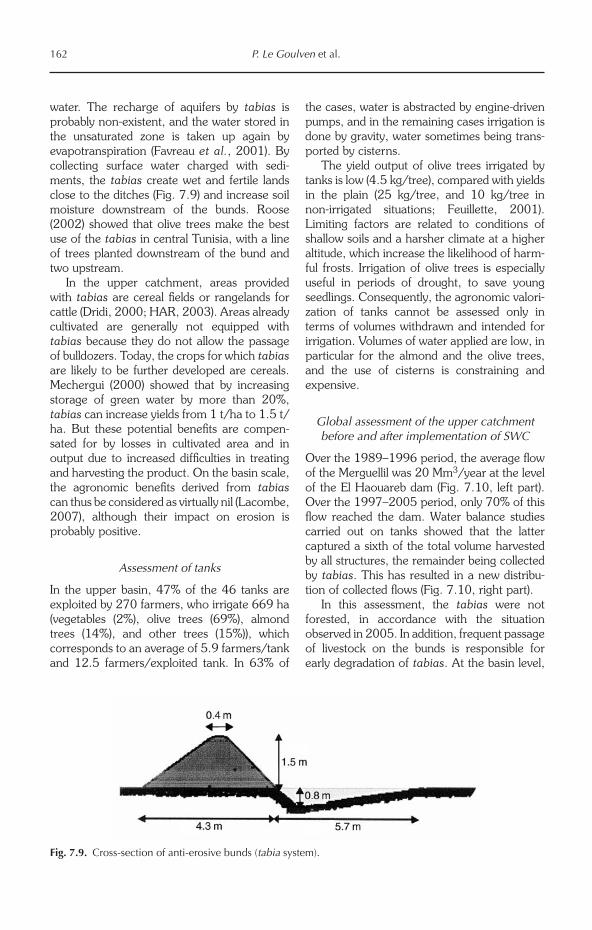
water. The recharge of aquifers by tabias is probably non-existent, and the water stored in the unsaturated zone is taken up again by evapotranspiration (Favreau et al., 2001). By collecting surface water charged with sedi-ments, the tabias create wet and fertile lands close to the ditches (Fig. 7.9) and increase soil moisture downstream of the bunds. Roose (2002) showed that olive trees make the best use of the tabias in central Tunisia, with a line of trees planted downstream of the bund and two upstream.
In the upper catchment, areas provided with tabias are cereal fields or rangelands for cattle (Dridi, 2000; HAR, 2003). Areas already cultivated are generally not equipped with tabias because they do not allow the passage of bulldozers. Today, the crops for which tabias are likely to be further developed are cereals. Mechergui (2000) showed that by increasing storage of green water by more than 20%, tabias can increase yields from 1 t/ha to 1.5 t/ha. But these potential benefits are compen-sated for by losses in cultivated area and in output due to increased difficulties in treating and harvesting the product. On the basin scale, the agronomic benefits derived from tabias can thus be considered as virtually nil (Lacombe, 2007), although their impact on erosion is probably positive.
Assessment of tanks
In the upper basin, 47% of the 46 tanks are exploited by 270 farmers, who irrigate 669 ha (vegetables (2%), olive trees (69%), almond trees (14%), and other trees (15%)), which corresponds to an average of 5.9 farmers/tank and 12.5 farmers/exploited tank. In 63% of
the cases, water is abstracted by engine-driven pumps, and in the remaining cases irrigation is done by gravity, water sometimes being trans-ported by cisterns.
The yield output of olive trees irrigated by tanks is low (4.5 kg/tree), compared with yields in the plain (25 kg/tree, and 10 kg/tree in non-irrigated situations; Feuillette, 2001). Limiting factors are related to conditions of shallow soils and a harsher climate at a higher altitude, which increase the likelihood of harm-ful frosts. Irrigation of olive trees is especially useful in periods of drought, to save young seedlings. Consequently, the agronomic valori-zation of tanks cannot be assessed only in terms of volumes withdrawn and intended for irrigation. Volumes of water applied are low, in particular for the almond and the olive trees, and the use of cisterns is constraining and expensive.
Global assessment of the upper catchment before and after implementation of SWC
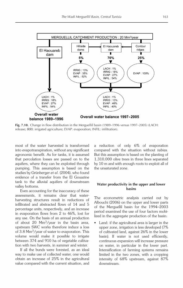
Over the 1989–1996 period, the average flow of the Merguellil was 20 Mm3/year at the level of the El Haouareb dam (Fig. 7.10, left part). Over the 1997–2005 period, only 70% of this flow reached the dam. Water balance studies carried out on tanks showed that the latter captured a sixth of the total volume harvested by all structures, the remainder being collected by tabias. This has resulted in a new distribu-tion of collected flows (Fig. 7.10, right part).
In this assessment, the tabias were not forested, in accordance with the situation observed in 2005. In addition, frequent passage of livestock on the bunds is responsible for early degradation of tabias. At the basin level,
Fig. 7.9. Cross-section of anti-erosive bunds (tabia system).
The Wadi Merguellil Basin, Central Tunisia 163
most of the water harvested is transformed into evapotranspiration, without any significant agronomic benefit. As for tanks, it is assumed that percolation losses are passed on to the aquifers, where they can be exploited through pumping. This assumption is based on the studies by Grünberger et al. (2004), who found evidence of a transfer from the El Gouazine tank to the alluvial aquifers of downstream valley bottoms.
Even accounting for the inaccuracy of these assessments, it remains clear that water-harvesting structures result in reductions of infiltrated and abstracted flows of 14 and 5 percentage units, respectively, and an increase in evaporation flows from 2 to 46%, lost for any use. On the basis of an annual production of about 20 Mm3/year in the basin area, upstream SWC works therefore induce a loss of 3.8 Mm3/year of water to evaporation. This volume would make it possible to irrigate between 374 and 910 ha of vegetable cultiva-tion with two harvests, in summer and winter.
If all the bunds were forested, as an ideal way to make use of collected water, one would obtain an increase of 25% in the agricultural value compared with the current situation, and
a reduction of only 6% of evaporation compared with the situation without tabias. But this assumption is based on the planting of 1,310,000 olive trees in three lines separated by 10 m and with enough roots to exploit all of the unsaturated zone.
Water productivity in the upper and lower basins
The econometric analysis carried out by Albouchi (2006) on the upper and lower parts of the Merguellil basin for the 1994–2003 period examined the use of four factors mobi-lized in the aggregate production of the basin:
• Land: if the agricultural area is larger in the upper zone, irrigation is less developed (7% of cultivated land, against 26% in the lower basin). If water is not used efficiently, continuous expansion will increase pressure on water, in particular in the lower part. Intensification of farming systems remains limited in the two zones, with a cropping intensity of 68% upstream, against 87% downstream.
Fig. 7.10. Change in flow distribution in the Merguellil basin (1989–1996 versus 1997–2005) (LACH: release; IRRI: irrigated agriculture; EVAP: evaporation; INFIL: infiltration).
164 P. Le Goulven et al.
• Water: water consumption strongly in creased in the two zones, from 5.5 to 9 Mm3 in the upper basin and from 13.5 to 34 Mm3 in the lower basin, i.e. increases of 65% and 152%, respectively. In contrast, we can observe a drop in water consump-tion per hectare on irrigated land in the downstream part, but withdrawals are still at 3859 m3/ha, against 2315 m3/ha in the upper basin. This lower application of water upstream reflects a still ‘extensive’ and recent irrigation, but farmers are increas-ingly attracted by crops with high added value. Downstream irrigators are already specialized in such products and, rather, seek to save water in order to expand their plots.
• Labour: agricultural employment, including available family labour and occasional hired labour, increased by approximately 13% in the two zones because of the expansion of irrigated areas and of the limited mechaniza-tion of agriculture. Increases in employment and per hectare labour input are higher in the lower basin (twice the values for the upper basin), which can be explained by the intensity of labour demand in vegetable cultivation. Farms in the upper part are characterized by lesser integration into the market, and resort to the abundant family labour and seasonal migrations to the lower basin, when occasional labour may amount to 60% of all labour requirements.
• Capital: capital is limited to the use of vari-able inputs; collected data evidenced a more intensive use of capital in the lower part, 203 Tunisian Dinars (DT)/ha versus 82 DT/ha in the upper part, which reflects the differential level of intensification. Produc-tion of cereals and vegetables is higher downstream (12,550 t and 56,280 t, against 12,240 t and 7740 t upstream), due to the irrigation of the former (maize, barley) and to a better technical control of the latter. However, tree and animal production are still higher upstream, because of the impor-tance of olive trees and because all herds (sheep, goats, cattle) are larger.
The net income is understandably higher in the downstream part, with a 10-year observa-tion average value of DT 12.3 million. In the
upstream part, this income only totalled DT 2.5 million and was even negative during the first 4 years of observation, showing that the land and family labour factors were not valued at market prices. This can explain the migration of young people from the upper to the lower part of the basin, where irrigation allows for the remuner-ation of all factors and the accumulation of profit.
The price of irrigation water varies between 0.08 and 0.12 DT/m3 over the whole zone of study, while average water productivity is 0.18 DT/m3 upstream and 0.39 DT/m3 down-stream. This shows the existence of rents in the two zones, particularly downstream, where revenue is accumulated in the value of land. The analysis also indicates that there is consid-erable potential to improve the economic effi-ciency of the two zones and to increase the generated overall income. A first estimate of the determinants of efficiency discards factors like specialization, integration into the market, availability of fodder or the degree of technical assistance, which are statistically non-signifi-cant. The effect of water saving is significant but weak, which can be explained by a poor command of these recently introduced tech-niques and by a tendency to expand irrigated areas rather than to intensify cultivation on them (Bachta et al., 2000). Access to credit has a strong positive effect on technical, alloca-tive and economic efficiency; according to some farmers, the lack of financing is much more constraining than the lack of water. Producers having access to credit generally have better information on the prices of prod-ucts and of production factors, and are more motivated to adopt new technologies. Finally, small-scale farming negatively influences both technical and economic efficiency, which suggests that a land policy designed to prevent or limit the fragmentation of farms would be desirable.
According to the analysis, continued imple-mentation of SWC works in the upper basin without attendant public support would lead to a drop of overall gross product in the basin. Further construction would deprive the most productive downstream zone of part of its water supply and would accentuate pressure on the aquifer. This loss can be mitigated by increasing the efficiency of the upper basin
The Wadi Merguellil Basin, Central Tunisia 165
(land reform, access to credit), but none of the scenarios considered is able to reverse the conclusions of the analysis.
Prospective Analysis
Possible or planned changes
There is often confusion between hydrological variability, which is naturally very high in the Mediterranean region, and climate change. Until now, no statistically significant change in rainfall has been observed at the Mediterranean scale (Cudennec et al., 2007), although depending on authors and methods, opposite conclusions were proposed in countries such as Spain and Italy. An overall worsening of rainfall in the Mediterranean basin remains hypothetical. At the Tunisian scale, the study of 43 long data sets of rainfall (Sakiss et al., 1994) did not find any consistent trend. Changes that could be identified at an even smaller scale, such as central Tunisia (e.g. Kingumbi et al., 2005), have to be put in the context of this overall stability.
Present global circulation models do not represent the Mediterranean climate with satis-fying accuracy, especially with regard to the extreme rainfall variability in time and space. Whatever the future climate in Tunisia, climatic changes in other parts of the world may also affect the study area in indirect ways. The recent worldwide rise in cereal prices, for example, partly linked to droughts in North America and Australia, led to a quick and unex-pected increase in the Tunisian fixed prices.
The previous sections showed that the most important and rapid changes in regional water resources are consequences of human activi-ties on the environment, and the induced redis-tribution of water in time and space, between blue water and green water, groundwater and surface water, and upstream and downstream parts of the basin. New conservation works planned by the authorities consist of three dams and bench terraces over 30,000 ha, which will further decrease the river flow, the inflow to the El Haouareb dam and, conse-quently, the recharge of the Kairouan plain aquifer.
Concerning the uses of water, Tunisia is
characterized by a recent fast demographic growth (population has doubled since 1970 but is now levelling off), a concentration of the population in the coastal urban centres and a seasonal peak in the flux of foreign tourists (6 million/year). The increases in population and in the standard of living, and improved cover-age of water supply in rural areas, have resulted in a continuous rise in domestic water demand. At the local scale, the Merguellil basin experi-enced a continuous demographic growth up to 1994, but the 2004 census showed a more complex evolution in recent years. While Kairouan and its surroundings continue to grow, an exodus of the rural population towards towns close to Chébikah and Haffouz is observed. This trend, caused by social and economic problems, is likely to continue in the next decades, according to the pattern widely observed in the Mediterranean basin.
These local and regional trends will increase the demand for water transfers towards urban and tourist centres of the Sahel, which already amount to 12 Mm3/year, as well as withdraw-als for the local population and industries (pres-ently 15 Mm3/year). But the water demand for agriculture is, and will remain, the biggest problem. With the integration of Tunisia into the world agricultural markets, the growing demand from local and tourist populations, vegetable farming – a very water- and labour-intensive activity – should continue to expand, together with plantations of new fruit species in demand on the world market (almonds, apples, etc.).
The future of SWC works
The SWC works of the upper basin are not completely satisfactory: a large part of the harvested water is lost by evaporation and very few new water uses have developed. In theory, the planting of 1.3 million olive trees would allow full use of the harvested water, but this number should be doubled to make the tabias, planned up to 2011, profitable. This hypothe-sis appears quite unrealistic, in particular because they require regular maintenance. In the absence of maintenance, they are damaged by breaches, which automatically cause other breaches in other tabias downstream. This
166 P. Le Goulven et al.
succession of ruptures accentuates the runoff concentration and leads to the formation of gullies. Erosion in areas of SWC works without maintenance is then even worse than in natural conditions. Studies on small tanks in El Gouazine showed that, 8 years after their construction, these SWC works had already lost 60% of their storage capacity. The runoff coefficient and the sediment transport went back to their initial values before the SWC works (Nasri et al., 2004).
Under such conditions, there is little likeli-hood that the remaining population of the upper basin will undertake the maintenance of plantations and conservation works, especially when people were not consulted during their construction, or even opposed them, thus forc-ing authorities to build them on public land.
Small tanks were initially established to trap sediments and to protect the El Haouareb dam. They fulfil their role properly since their average lifespan is about 20–25 years. Currently, only some of the largest and well-located tanks are exploited in an intensive way. In general, there is no collective management, with each irrigator using pump sets subsidized by the government to abstract water from the tank. Intensification is limited because the risk of water shortage is high, especially during drought years. Setting up water user associations is not expected to change this situation, especially given the fast sedimentation of the reservoirs.
It is often said that global warming will increase the frequency of extreme events, in particular droughts lasting several years, with more irregular rainfall. If such changes occur, they would be detrimental to the lifespan of SWC works (via breaching, faster filling) and to their usefulness, because ditches are not able to store water to bridge rain events. However, the El Haouareb dam would be of greater interest in stopping exceptional floods and reassuring rural and urban populations down-stream in the Kairouan plain. It is large enough to undergo sedimentation and subsequent reduction in storage for many years.
One can thus imagine the future with an extensive use of most of the basin upstream (rainfed farming of olive trees and cereals, grazing lands) and an intensive exploitation of land endowed with groundwater resources, on an area that would guarantee water supply for
a sequence of drought years. In addition to its protective role against flooding of the city, the El Haouareb dam would only be used to trans-fer water to the Kairouan aquifer. The manage-ment of water in the zone would be, in fact, essentially limited to the management of groundwater.
Groundwater management
Dynamics of the upper basin aquifers (Haffouz, Aïn Beidha, BouHafna) are insufficiently known (recharge, connections), but the first models available emphasize their fragility. They are exploited by private wells, without any control on withdrawals, and also supply the Sahel region with domestic water. The Kairouan plain aquifer supplies about 15 well-based public schemes and thousands of private wells, manually deepened if necessary when the water table drops. Although formally a protected area, the Kairouan aquifer remains, in fact, a free-access collective resource: restric-tive regulations are not respected and hand-dug boreholes are always more numerous, even in public schemes. Farmers attempt to free themselves from the rigidity of water turns and directly access groundwater to cultivate melon and watermelon with drip-irrigation. Law enforcement is difficult because the water police function is entrusted to the institution in charge of regional development, which chooses to preserve social peace in an area struck by unemployment rather than to safeguard the long-term durability of the system.
Water shortages are not imminent, given the thickness of the aquifer, but the continuous drop in the groundwater level will make access to water more and more difficult for small producers; those located at the aquifer margins will see their resource disappear. In addition, the deeper layers of the aquifer have lower transmissivity and a higher mineral content. Water quality will most likely deteriorate in the long term.
Aware of the importance of aquifers, Tunisian authorities explore various recharge techniques, even if this will probably not be sufficient to offset overdraft. The El Haouareb dam loses most of its water through karstic cracks, which constitute an unexpected but interesting process
The Wadi Merguellil Basin, Central Tunisia 167
of recharge of the Kairouan plain aquifer. This saves water from evaporation and smoothes inter-annual climatic fluctuations (the storage capacity of the Kairouan plain aquifer is much higher than the dam’s, by more than an order of magnitude). The rest of the dam water is pumped for irrigation and also evaporates. Keeping water in the dam for satisfying the irri-gation demand is a short-term approach, but is not pertinent at a regional scale. A more proac-tive management would include dam releases in spring, in order to save a part of the dam water presently lost by evaporation (five times higher in July than in January). According to our calcu-lations, about half of the released volumes would be gained by the Kairouan plain aquifer: since 1989, 24 Mm3 could have been saved, which is greater than the mean annual groundwater inflow to the Kairouan aquifer from the dam and the upstream Aïn Beidha aquifer over the same period. Obviously, such an improvement would only bring a limited amount of ‘new’ water into the regional water budget, but this is the most efficient solution in a region where water resources are scarce and already overex-ploited.
Alternative solutions should also be searched for. Urban and tourist centres of the Sahel coast could turn to desalination of seawater for domestic supply, as in several other Mediter-ranean areas. The price of desalination strongly dropped with the development of reverse osmosis (between €0.5 and €1.00 per m3). For instance, the Balearic Islands and the Canaries resort to desalination to meet the demand of the tourist season, as does Andalusia, which runs several plants in order to avoid conflicts between tourist and agricultural activities.
The overexploitation of the aquifers in the basin cannot be stopped without an effective management of agricultural demand and its acceptance by the population. An agent-based simulation model was used to test various management policies (Feuillette et al., 2003) by representing the interactions between water supply and demand, investment strategies of farmers and their decisions to dig wells, and interactions between farmers. A first scenario simulates the impact of adoption of drip-irriga-tion systems, as advocated by the authorities. The model revealed an increase in farm income but a very clear rise in pumping and in the number of wells. Ground-truthing showed that
the farmers make a benefit after 1 year only because the drip system is subsidized by the government by up to 60%. This enables farm-ers to grow melons and watermelons, sold at a good price to the hotels on the coast, 100 km away. In the following years, farmers try to increase production by all means: extension of the irrigated area, renting of additional land, increase in the power of pumps, digging of new wells, etc. The shift to micro-irrigation, without attendant measures, would compound the over-exploitation of the aquifer, i.e. the exact oppo-site of the expected outcome. Additional simulations showed that the combination of drip-irrigation and a very high pricing of water when used beyond a given quota gives the best results: reasonable profit-making by farmers through a better valorization of water combined with a substantial reduction in total with-drawals.
To enforce regulation, the administration can try to control current individual dynamics by strengthening control: electrification of all the pump sets, systematic installation of three-phased electric meters and political support to the national electric company to recover fees. Such proposals are obviously difficult to imple-ment. The administration can also initiate a process of turning management responsibilities over to water user associations at the borehole level. Faysse (2001) showed the collective bene-fit resulting from the application of flexible rules by an association of irrigators. Concerning deep-well-based irrigation schemes, manage-ment by associations with increasingly broad attributions, and the disengagement of the state at the CRDA level, gradually become the rule. However, the adoption of a more participatory management could be temporarily hindered by difficulties in identifying supportive interest groups. The support of users, who have long been kept away from management, will proba-bly come up with the awareness of the fragility of the aquifer, regarded until now as an inex-haustible resource crossed by large underground rivers.
Conclusion
Located in the heart of Tunisia in a semi-arid zone, the Merguellil basin belonged, until the

168 P. Le Goulven et al.
19th century, to a tribe-based society. Agricultural modes of production typical of this Mediterranean environment combined a concentration of investments on the limited areas where water was accessible with an extensive exploitation of scattered pastoral resources.
During the French protectorate, the arrival of a few colonists induced a first modification of land use, but the most important changes in land and water resources development policies happened after independence, when the appearance of the basin was deeply modified: closing of the basin by the El Haouareb dam in 1989, and implementation of water-harvesting structures and small tanks since the 1980s.
The Merguellil basin is typical of the prob-lems faced in Tunisia and in the Mediterranean basin in general: limited water resources; inter-mittent flows; strong increase in, and diversifi-cation of, demand; strong human-induced hydrological changes; competition between declining upstream rural societies and a more dynamic urban/tourist downstream, or coastal, zone; and very localized uses of overexploited aquifers.
The soil and water conservation (SWC) works in the Merguellil basin, planned at the national level and implemented without consul-tation or participation of the users, are conse-quently very poorly exploited. These works result in a reduction of infiltration and abstrac-tion and in a substantial increase in losses by evaporation. By reducing surface runoff, they also decrease the inflow to the El Haouareb dam and, consequently, the recharge of the Kairouan aquifer, which is used in a very productive way.
The SWC works are likely to deteriorate with time because the administration has not planned any maintenance and the population hardly feels concerned. In the near future, management of aquifers will be the central issue, because of their pivotal role in support-ing intensification of irrigated production and supplying cities. The remainder of the basin will probably remain confined to extensive farming: rangelands and rainfed farming of cereals and olive trees.
To restore a balanced use of the aquifers without impacting the development of the area too much, the administration will have to implement demand-management policies, an uphill battle with very few successes recorded worldwide.
Acknowledgments
We wish to thank all those who took part in the work undertaken on the Merguellil basin, within the framework of the MERGUSIE programme, and in particular the many students of Tunisian and French universities. Thank you all those who elaborated the various thematic syntheses within the framework of a convention with IWMI: their documents were used as a support of this chapter.
Notes
1 Fesguias are big public water tanks with a capacity that can reach hundreds of cubic metres.
2 Gouvernorat, or wilaya in Arabic: administrative region directed by a governor appointed by the president. There are 24 gouvernorats in Tunisia.
References
Albouchi, L. (2006) Gestion de l’eau en Tunisie: d’une période de mobilisation à une politique de réallocation de la ressource selon sa valorization économique. Cas du bassin versant du Merguellil, Tunisie Centrale. PhD thesis, University Montpellier I, Montpellier, France.
Bachta, M.S. and Zaibet, L. (2006) Espaces agraires et environnement en Tunisie: la permanence des cadres spatiaux au cours du 20ème siècle. Séminaire sur l’avenir de l’agriculture en Méditerranée, projet UE Wademed, Cahors, France, 6th November 2006.
Bachta, M.S., Le Goulven, P., Le Grusse, P. and Luc J.P. (2000) Environnement institutionnel et relations physiques pour une gestion intégrée de l’eau dans le milieu semi-aride méditerranéen. Le cas tunisien. Séminaire International Montpellier 2000, “Hydrologie des Régions Méditerranéennes”. Montpellier, France, 11–13 Octobre 2000. PHI-V/ Documents Techniques en Hydrologie, 51, 177–186.
The Wadi Merguellil Basin, Central Tunisia 169
Bachta, M.S., Zaibet, L. and Albouchi, L. (2005) Impact Assessment of Water Resources Development in the Merguellil Basin: Kairouan, Tunisia. Report for the Comprehensive Assessment of Water Management in Agriculture. International Water Management Institute, Colombo, Sri Lanka.
Bedoucha, G. (1987) L’Eau, l’Amie du Puissant. Une Communauté Oasienne du Sud Tunisien. Editions des Archives Contemporaines, Paris.
Ben Ammar, S., Zouari, K., Leduc, C. and M’Barek, J. (2006) Caractérisation isotopique de la relation entre barrage et nappe dans le bassin du Merguellil (plaine de Kairouan, Tunisie centrale). Hydrological Sciences Journal 51(2), 272–284.
Ben Mansour, H. (2006) Dynamiques des Ouvrages de Conservation des Eaux et des Sols dans le Bassin Amont du Merguellil. Report for the Comprehensive Assessment of Water Management in Agriculture. International Water Management Institute, Colombo, Sri Lanka.
Bouzaïane, S. and Lafforgue, A. (1986) Monographie Hydrologique des Oueds Zeroud et Merguellil. Technical report. Directorate Générale des Ressources en Eau/Institut Française de Recherche Scientifique pour le Développement en Coopération, Tunis, Tunisia.
Cudennec, C., Leduc, C. and Koutsoyiannis, D. (2007) Dryland hydrology in Mediterranean regions – a review. Hydrological Sciences Journal 52(6), 1077–1087.
DGRE (Direction Générale des Ressources en Eau) (1995) Situation de l’Exploitation des Nappes Phréatiques. Technical report. Ministère de l’Agriculture, Tunisia.
Dridi, B. (2000) Impact des aménagements sur la disponibilité des eaux de surface dans le bassin versant du Merguellil (Tunisie centrale). PhD thesis, University of Strasbourg, France.
Favreau G., Leduc C. and Schroeter, P. (2001) Reply to comment on ‘Long-term rise in a Sahelian water-table: the Continental Terminal in South-West Niger’ by Leduc, C., Favreau, G., Schroeter, P. (2001). Journal of Hydrology 243, 43–54; Journal of Hydrology 255(1–4), 263–265.
Faysse, N. (2001) L’influence des règles collectives d’allocation de l’eau sur les choix stratégiques des agriculteurs. Des petits périmètres irrigués tunisiens aux prélèvements en rivière dans le bassin de l’Adour. PhD thesis, University of Paris, X Nanterre, Paris.
Feuillette, S. (2001) Vers une gestion de la demande sur une nappe en accès libre: exploration des interactions ressources usages par les systèmes multi-agents. Application à la nappe de Kairouan, Tunisie Centrale. PhD thesis, University of Montpellier II, Montpellier.
Feuillette, S., Le Goulven, P. and Bachta, M.S. (1998) Les pouvoirs législatifs, règlementaires et juridiques en Tunisie confrontés à la gestion des nappes souterraines. Colloque SFER « L’irrigation et la gestion collective de la ressource en eau en France et dans le monde », Montpellier, 19–20th November 1998.
Feuillette, S., Bousquet, F. and Le Goulven, P. (2003) SINUSE: a multi-agent model to negotiate water demand management on a free access water table. Environmental Modelling & Software 18(5), 413–427.
Genin, D., Guillaume, H., Ouessar, M., Ouled Belgacem, A., Romagny, B., Sghaïer, M. and Taamallah, H. (2006) Entre Désertification et Développement, la Jeffara Tunisienne. IRD–Cérès Editions–IRA, Paris.
Géroudet, C. (2004a) Histoire du Peuplement et Histoire Agraire. Report for the Comprehensive Assessment of Water Management in Agriculture. International Water Management Institute, Colombo, Sri Lanka. www.iwmi.cgiar.org/assessment/files/word/projectdocuments/merguellil/partie1.pdf
Géroudet, C. (2004b) Politiques Agricoles et Structures Foncières. Report for the Comprehensive Assessment of Water Management in Agriculture. International Water Management Institute, Colombo, Sri Lanka. www.iwmi.cgiar.org/assessment/files/word/projectdocuments/merguellil/partie2.pdf
Géroudet, C. (2004c) Evolution Démographique de 1966 à Nos Jours. Report for the Comprehensive Assessment of Water Management in Agriculture. International Water Management Institute, Colombo, Sri Lanka. www.iwmi.cgiar.org/assessment/files/word/projectdocuments/merguellil/partie3a.pdf
Grünberger, O., Montoroi, J.P. and Nasri, S. (2004) Quantification of water exchange between a hill reservoir and groundwater using hydrological and isotopic modelling. El Gouazine, Tunisia. C.R. Geoscience 336, 1453–1462.
HAR (Société d’hydraulique et d’aménagement rural) (2003) Etude de Planification des Aménagements CES dans le Gouvernorat de Silinana. Phase 2. Rapport Final Pour la Direction Générale de l’Aménagement et de la Conservation des Terres Agricoles (DG/ACTA). Ministère de l’Agriculture, de l’Environnement et des Ressources Hydrauliques, Tunis, Tunisia.
Kingumbi, A. (1999) Bilan et Modélisation de la Retenue du Barrage d’El Haouareb. Mémoire de DEA en Modélisation Hydraulique et Environnement. Ecole Nationale d’Ingénieurs de Tunis, Tunis, Tunisia.
Kingumbi, A. (2006) Modélisation hydrologique d’un bassin affecté par des changements d’occupation. Cas du Merguellil en Tunisie centrale. PhD thesis, University of Tunis, El Manar, Tunisia.
Kingumbi, A., Bargaoui, Z. and Hubert, P. (2005) Investigation of the rainfall variability in the central part of Tunisia. Hydrological Sciences Journal 50(3), 493–508.
170 P. Le Goulven et al.
Lacombe, G. (2007) Evolution et usages de la ressource en eau dans un bassin versant aménagé semi-aride. Le cas du Merguellil en Tunisie Centrale. PhD thesis, University of Montpellier 2, Montpellier.
Luc, J.P. (2005) Blue and Green Water and Water Accounting: the Merguellil River Basin. Report for the Comprehensive Assessment of Water Management in Agriculture. International Water Management Institute/Institut de recherche pour de développement, Tunisia. www.iwmi.cgiar.org/assessment/files_new/research_projects/river_basin_development_and_management/bluegreenwater_rapport_luc.pdf
Mahfoudh, F., Baccouch, S. and Yazidi, B. (2004) L’Histoire de l’Eau et des Installations Hydrauliques dans le Bassin de Kairouan. Report for the Comprehensive Assessment of Water Management in Agriculture. International Water Management Institute, Colombo, Sri Lanka. http://www.iwmi.cgiar.org/assessment/files/word/projectdocuments/merguellil/histoire eau kairouan.pdf
Mechergui, M. (2000) La petite hydraulique et son impact sur la vie du paysan, les eaux de ruissellement, la conservation en eau et en sol et les ressources en eau vers l’aval dans un bassin versant: cas de deux bassins versants de Siliana et du Kef en Tunisie. Conférence: Relations terre-eau dans les bassins versants ruraux, Conférence électronique, 18 septembre au 27 octobre 2000. FAO, Rome, www.fao.org/AG/agL/watershed/watershed/papers/papercas/paperfr/case18fr.pdf
Nasri, S. (2007) Caractéristiques et impacts hydrologiques de banquettes en cascade sur un versant semi-aride en Tunisie centrale. Hydrological Sciences Journal 52(6), 1134–1145.
Nasri, S., Albergel, J., Berndtsson, R. and Lamachère, J.M. (2004) Impact des banquettes sur le ruissellement d’un petit bassin versant. Revue des Sciences de l’Eau 17(2), 265–289.
Nazoumou, Y. (2004) Analyse du Réservoir Aquifère de la Plaine de Kairouan. Report for the Comprehensive Assessment of Water Management in Agriculture. International Water Management Institute, Colombo, Sri Lanka.
Roose, E. (2002) Banquettes mécaniques et techniques traditionnelles de GCES pour la zone méditerranéenne semi-aride de Tunisie. In: Roose, E., Sabir, M. and De Noni, G. (eds) Techniques Traditionnelles de GCES en Milieu Méditerranéen. Institut de recherche pour le développement, Rabat, Morocco, pp. 155–168.
Sakiss, N., Ennabli, N., Slimani, M. and Baccour, H. (1994) La Pluviométrie en Tunisie a-t-elle Changé Depuis 2000 ans? Institut National de la Météorologie & Institut National Agronomique de Tunisie, Tunis, Tunisia.
Treyer, S. (2002) Analyse des Stratégies et Prospectives de l’eau en Tunisie. Rapport I: Monographie de L’eau en Tunisie. Report for ‘Plan Bleu’. Plan Bleu, Foundation Sophia Antipolis, Antibes, France.
Le Goulven Patrick, Leduc Christian, Salah Bachta M.,
Poussin Jean-Christophe.
Sharing scarce resources in a Mediterranean river basin
: Wadi Merguellil in central Tunisia.
In : Molle François (ed.), Wester P. (ed.). River basin
trajectories : societies, environments and development.
Wallingford : CABI, 2009, p. 147-170.
(Comprehensive Assessment of Water Management in
Agriculture ; 8).
ISBN 978-1-84593-538-2


![Performance of LBSap Vaccine after Intradermal Challenge ... · including regions of the Americas, the Mediterranean basin, Asia and Europe [3]. Often, the prevalence of infected](https://img.pdfslide.fr/doc/110x75/5fd16613a4452b211773550c/performance-of-lbsap-vaccine-after-intradermal-challenge-including-regions-of.jpg)