Embed Size (px)
Citation preview
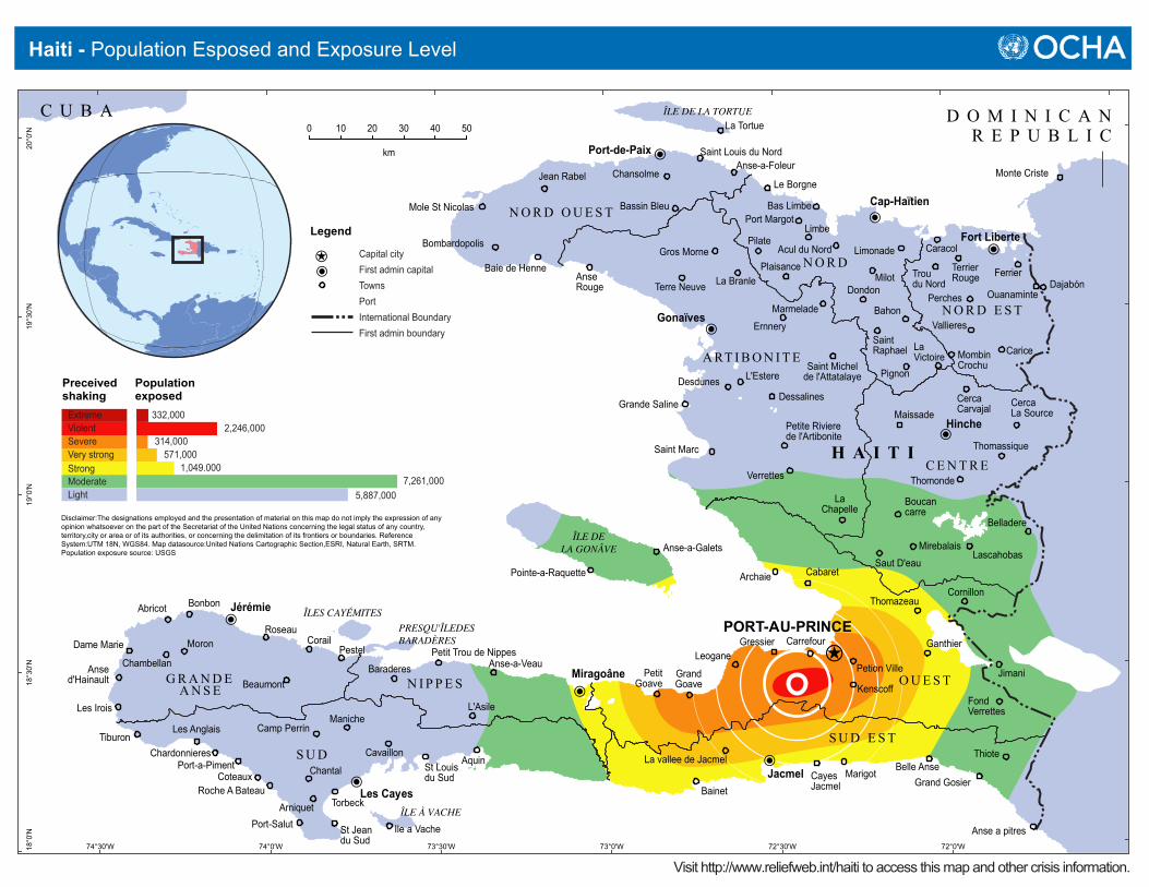
PORT-AU-PRINCE
Cap-Haïtien
Gonaïves
Hinche
Jacmel
Jérémie
Les Cayes
Miragoâne
Port-de-Paix
Fort Liberte
Les AnglaisTiburon
Chantal
Arniquet
Camp PerrinManiche
CavaillonSt Louisdu Sud
Aquin
GrandGoave
PetitGoave
Bainet
Pestel
Roseau
BonbonAbricot
Dame Marie
Les Irois
Moron
Ansed'Hainault Beaumont
CorailPetit Trou de Nippes
Baraderes Anse-a-Veau
L'Asile
La vallee de JacmelCayesJacmel
Marigot
Ernnery
CercaCarvajal
Vallieres
TerrierRougeTrou
du Nord
CercaLa Source
Thomassique
Belladere
Jimani
LascahobasSaut D'eau
Thomonde
Maissade
Pignon
LaVictoire Mombin
Crochu
Bahon
Milot
Limonade
Dondon
SaintRaphael
Marmelade
Saint Michelde l'Attatalaye
Dessalines
Petite Rivierede l'Artibonite
Verrettes
LaChapelle
Mirebalais
Grande Saline
Desdunes L'Estere
AnseRouge
Mole St Nicolas
Bombardopolis
Baie de Henne
Jean Rabel
Bassin Bleu
ChansolmeAnse-a-Foleur
Saint Louis du Nord
Le Borgne
Port MargotLimbe
PilateGros Morne
La BranlePlaisance
Anse a pitres
Grand Gosier
FondVerrettes
Ganthier
Thomazeau
CabaretArchaie
LeoganeChambellan
Perches
Ferrier
Carice
Bas Limbe
Acul du Nord
Terre Neuve
Boucancarre
Kenscoff
Carrefour
Petion Ville
Gressier
Cornillon
Ile a Vache
Anse-a-Galets
Pointe-a-Raquette
La Tortue
Caracol
Belle Anse
Torbeck
St Jeandu Sud
Port-Salut
CoteauxPort-a-Piment
Chardonnieres Thiote
Roche A Bateau
Ouanaminte
Monte Criste
Dajabón
Saint Marc
C U B A D O M I N I C A NR E P U B L I C
H A I T I
S U D E S T
N O R D E S T
A RT I B O N I T E
C E N T R E
S U D
G R A N D EA N S E
N O R D O U E S T
N I P P E S
N O R D
O U E S T
ÎLE DE LA TORTUE
ÎLE DELA GONÂVE
PRESQU'ÎLEDESBARADÈRES
ÎLES CAYÉMITES
ÎLE À VACHE
72°0'W72°30'W73°0'W73°30'W74°0'W74°30'W
20°0
'N19
°30'
N19
°0'N
18°3
0'N
18°0
'N
0 10 20 30 40 50
km
Legend
Capital cityFirst admin capitalTowns
International BoundaryPort
First admin boundary
Disclaimer:The designations employed and the presentation of material on this map do not imply the expression of any opinion whatsoever on the part of the Secretariat of the United Nations concerning the legal status of any country, territory,city or area or of its authorities, or concerning the delimitation of its frontiers or boundaries. Reference System:UTM 18N, WGS84. Map datasource:United Nations Cartographic Section,ESRI, Natural Earth, SRTM. Population exposure source: USGS
Haiti - Population Esposed and Exposure Level
Visit http://www.reliefweb.int/haiti to access this map and other crisis information.
LightModerate
Very strongSevereViolentExtreme
Preceivedshaking
7,261,0005,887,000
1,049.000571,000
314,0002,246,000
332,000
Populationexposed
Strong