Embed Size (px)
Citation preview
Descriptif / BeschreiBung / Description
Wettolsheim
Trois Épis
Soultzbach-les-Bains
EguisheimStosswihr
Munster
Ingersheim
Turckheim
Labaroche
Les Hautes Huttes
Wihr-au-Val
WintzenheimD417
D10
D417
D10
GR 532GR 531
D11
D48
D11
D11
D11
P A R C N A T U R E L R É G I O N A L
D E S B A L L O N S D E S V O S G E S
Fecht
Hohlandsbourg
MuséeMémorialdu Linge
Hagueneck
Les Trois Châteaux
0Légendes Cartographie
2,5 km
le Grand Hohnack982 m
765 m.966 m.
555 m.
456 m. Forêt Comm. d’Eguisheim
Forêt Comm. de Forêt Communale de Wihr-au-Val
Forêt C
om
m. d
e
W
ihr-a
u-Val
Forêt Comm. de Hattstatt
Forêt Comm. d’OrbeyCol du Wettstein
882 m.
Col de Marbach706 m.
Le Pré du Bois
Gueberschwihr
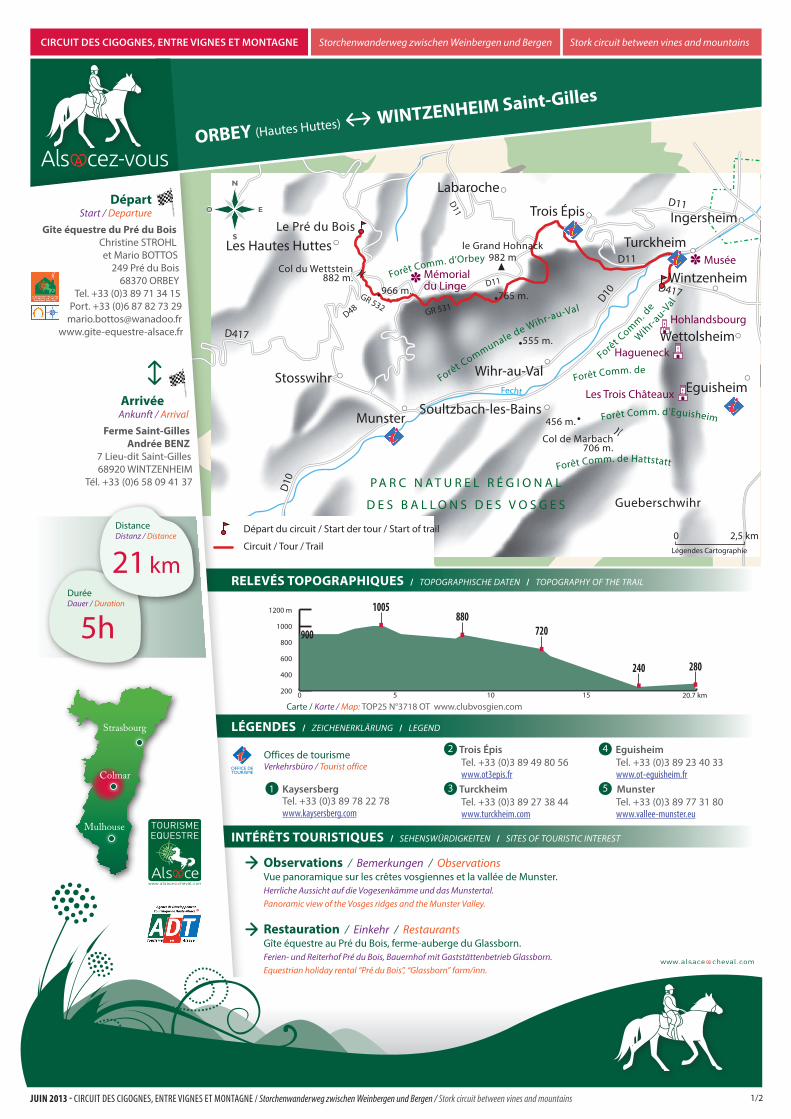
Départ du circuit / Start der tour / Start of trail
Circuit / Tour / Trail
LÉgendes / Zeichenerklärung / legend
IntÉrêts tourIstIques / SehenSwürdigkeiten / SiteS of touriStic intereSt
reLevÉs topographIques / topographiSche daten / topography of the trail
Strasbourg
Mulhouse
Colmar
5hDuréedauer / duration
21 km
Distancedistanz / distance
0 5 10 15 20.7 km200
400
600
800
1000
1200 m
900
1005880
720
240 280
orBeY (Hautes Huttes) WIntZenheIM saint-gilles
CirCuit des Cigognes, entre vignes et montagne Storchenwanderweg zwischen weinbergen und Bergen Stork circuit between vines and mountains
observations / Bemerkungen / observations Vue panoramique sur les crêtes vosgiennes et la vallée de Munster.herrliche aussicht auf die Vogesenkämme und das Munstertal.panoramic view of the Vosges ridges and the Munster Valley.
restauration / einkehr / restaurantsGîte équestre au Pré du Bois, ferme-auberge du Glassborn.ferien- und reiterhof pré du Bois, Bauernhof mit gaststättenbetrieb glassborn.equestrian holiday rental “pré du Bois”, “glassborn” farm/inn.
départ Start / departure
gîte équestre du pré du BoisChristine STROHL et Mario BOTTOS
249 Pré du Bois68370 ORBEY
Tel. +33 (0)3 89 71 34 15 Port. +33 (0)6 87 82 73 29
[email protected] www.gite-equestre-alsace.fr
arrivée ankunft / arrival
Ferme saint-gilles andrée BenZ
7 Lieu-dit Saint-Gilles 68920 WINTZENHEIM
Tél. +33 (0)6 58 09 41 37
Offices de tourismeVerkehrsbüro / tourist office
3 turckheim Tel. +33 (0)3 89 27 38 44 www.turckheim.com
2 trois Épis Tel. +33 (0)3 89 49 80 56 www.ot3epis.fr
5 munster Tel. +33 (0)3 89 77 31 80 www.vallee-munster.eu
4 eguisheim Tel. +33 (0)3 89 23 40 33 www.ot-eguisheim.fr
Carte / karte / Map: TOP25 N°3718 OT www.clubvosgien.com
1/2JUIN 2013 - CirCuit des Cigognes, entre vignes et montagne / Storchenwanderweg zwischen Weinbergen und Bergen / Stork circuit between vines and mountains
1 Kaysersberg Tel. +33 (0)3 89 78 22 78 www.kaysersberg.com
Descriptif / BeschreiBung / Description
0 km
1,8 km
5 km
7,5 km
18 km
0 km 0 km
1,8 km 1,8 km
5 km 5 km
7,5 km
7,5 km
12 km
Strasbourg
Mulhouse
Colmar
descrIptIF / BeSchreiBung / deScription
Départ du gîte équestre du Pré du Bois (alt. 850 m). Remonter le chemin du Pré du Bois vers le sud jusqu’au point côté 892, puis prendre à gauche.Suivre la route sur 200 m, et à l’intersection continuer tout droit vers le sud. Après 100 m, prendre le chemin qui part dans le virage et qui passe devant la ferme, en direction du Rain de la Croix. Rester sur le chemin jusqu’au point coté 876 à proximité du cimetière militaire français du Col du Wettstein (alt. 882 m).
Longer la route D 48 vers le sud sur 300 m jusqu’au croisement, tourner à gauche, longer le parking et emprunter le GR 532 (rectangle jaune) jusqu’à la Ferme Auberge du Glasborn (alt. 940 m). Au passage, admirez la vue panoramique sur les Crêtes Vosgiennes et la Vallée de Munster. Continuer sur le GR 532 vers le Schratzmaennele et rejoindre le Col du Baerenstall (alt. 975 m). On y trouve le cimetière militaire allemand. Attention : ne pas monter au sommet du Schratzmaennele, le contourner par le sud.
Traverser la route D 5 b1, et prendre le chemin balisé croix rouge qui descend à droite du cimetière, en direction de Gunsbach. Suivre le chemin sur 800 m jusqu'au point 863. Quitter ce chemin et suivre le chemin balisé croix jaune jusqu’a la Croix de Wihr.
A 200 m de la Croix de Wihr, quitter le chemin balise croix jaune pour prendre vers l’est le chemin non balisé, qui après 500 m est balisé chevalet bleu. Continuer ce chemin qui est balisé chevalet bleu sur 500 m, puis qui est non balisé, et rejoindre Giragoutte au point 802. Longer, puis traverser la route D 11 VI en suivant le balisage rectangle jaune. Après 250 m traverser à nouveau la route, passer au lieu-dit Obschel. possibilité de restauration à l’auberge obschel.
Quitter Obschel vers le sud par le chemin balisé croix bleue sur 1 km jusqu’aux grands chemins blancs, puis partir vers l’Est sur le chemin blanc en passant aux blockhaus, puis au lieu-dit Engelhof et rejoindre le point 349. Quitter ce chemin toujours vers l’Est pour rejoindre Turckheim au point 255.
Longer la rivière Fecht jusqu’au niveau du pont du camping.
Suivre le balisage rectangle jaune qui passe au lycée Agricole et au lieu-dit St Gilles.
Start am Reiterhof Pré du Bois (850 m Höhe). Den Weg Chemin du Pré du Bois Richtung Süden bis Punkt 892 aufsteigen, dann links abbiegen. Der Strasse 200 m folgen, an der Kreuzung geradeaus in Richtung Süden weiter reiten. Nach 100 m in den Weg in der Kurve einbiegen, der am Bauernhof vorbeiführt in Richtung Rain de la Croix. Bis Punkt 876 auf diesem Weg bleiben, nahe des französischen Soldatenfriedhofs des Wettstein-Passes (882 m Höhe).
300 m auf der D 48 Richtung Süden bleiben, an der Kreuzung links abbiegen, am Parkplatz entlang, dann den Wanderweg GR 532 (gelbes Rechteck) nehmen bis zum Bauernhof mit Gaststättenbetrieb Glasborn (940m Höhe). Genießen Sie die herrliche Aussicht über die Vogesenkämme und das Munstertal. Weiter auf dem GR 532 Richtung Schratzmaennele gelangen Sie zum Baerenstall-Pass (975 m Höhe). Hier liegt der deutsche Soldatenfriedhof. Achtung: Nicht zum Gipfel des Schratzmaennele aufsteigen, sondern ihn im Süden umreiten.
Die D 5 b1 überqueren und in den Weg mit der Markierung „rotes Kreuz“ einbiegen, der rechts vom Friedhof abgeht und hinunter nach Gunsbach führt. Dem Weg 800 m bis Punkt 863 folgen. Diesen Weg verlassen und den mit dem gelben Kreuz bis zum Kreuz von Wihr nehmen.
200 m davor diesen Weg verlassen, um nach Osten den Weg ohne Markierung zu nehmen. Nach 500m erhält er 500 m weit die Markierung „blaues Kreuz“ und verliert sie dann wieder. Darauf bis Giragoutte am Punkt 802 bleiben. An der Straße D 11 VI zuerst entlanggehen und sie dann überqueren indem man das gelbe Rechteck befolgt. Nach 250 m geht es wieder auf die andere Seite der Straße durch die Nebengemeinde Obschel. Verpflegungsmöglichkeit in der herberge obschel.
Obschel in Richtung Süden auf dem Weg mit blauem Kreuz verlassen und 1 km bis zu den großen weißen Wegen darauf bleiben, dann nach Osten auf dem weißen Weg an einem Blockhaus vorbei und durch die Nebengemeinde Engelhof bis zum Punkt 349 gehen. Diesen Weg immer Richtung Osten verlassen, um nach Turckheim am Punkt 255 zu kommen.
An der Fecht (ein Bach) entlang bis zur Campingbrücke reiten.
Der Markierung „gelbes Rechteck“ folgen, die am Landwirtschaftsgymnasium und an dem Nebenort „Saint-Gilles“ vorbeiführt.
Departure from the equestrian holiday rental "Pré du Bois". Go up the "Pré du Bois" path southwards until you reach PC 892, then turn left. Follow the road for 200 m and continue straight on southwards at the intersection. After 100 m, take the path that starts on the corner and passes in front of the farm, in the direction of Rain de la Croix. Stay on the path until PC 876, near the French Military Cemetery of the Col du Wettstein (alt. 882 m).
Take the D 48 road southwards for 300 m until the intersection, turn left, pass alongside the parking lot and take the GR 532 (yellow rectangle) as far as the "Glassborn" farm/inn (alt. 940 m). On the way, admire the panoramic view of the ridges of the Vosges and the Munster Valley. Continue on the GR 532 towards the Schratzmaennele to reach Col du Baerenstall (alt. 975 m). A German military cemetery is located here. NB: do not go up to the summit of Schratzmaennele, go around it to the south.
Cross the D 5 b1 road and take the path marked with red crosses that descends to the right of the cemetery, in the direction of Gunsbach. Follow the path for 800 m until you reach point 863. Leave this track behind you and follow the track that is waymarked with a yellow cross until you get to the Croix de Wihr.
200m away from the Croix de Wihr, leave the track that is waymarked with a yellow cross to take the non-waymaked track to the east. After 500m it turns into a waymarked track with a blue trestle. Carry on on this track which is waymarked with the blue stand over a distance of 500m, then ther is no waymarking and you meet up with Giragoutte at dot number 802. Ride along that track, then cross the D 11 VI road and follow the yellow rectangle waymark. 250m farther on, cross the road again , go past the hamlet called Obschel. you can have something to eat at the obschel inn.
Leave Obschel, head due south by taking the track that is waymarked with a blue cross over 1 Km till you get to the big white tracks, the head due east on the white track going past the blockhaus, then at the Engelhof hamlet and meetup with dot 349. Leave this track while still heading east to join up with Turckheim at dot 255.
Ride along the river Fecht until you get to the campsite bridge.
Follow the yellow rectangle waymarking that takes you past the lycée Agricole and to the hamlet called St Gilles.
CirCuit des Cigognes, entre vignes et montagne Storchenwanderweg zwischen weinbergen und Bergen Stork circuit between vines and mountains
21 km
12 km
18 km
21 km
18 km
12 km
21 km
2/2JUIN 2013 - CirCuit des Cigognes, entre vignes et montagne / Storchenwanderweg zwischen Weinbergen und Bergen / Stork circuit between vines and mountains
orBeY (Hautes Huttes) WIntZenheIM saint-gilles