Embed Size (px)
Citation preview

territorium 14
33
QUATERNARY EVOLUTION OF THE SERRA DO MARÃO AND ITS CONSEQUENCESIN THE PRESENT DYNAMICS
António de Sousa Pedrosa, Bernardo Serpa Marques,Bruno Martins, José Henrique Sousa
Faculdade de Letras, Universidade do [email protected]
RESUMO
Situada no Norte de Portugal, a Serra do Marão faz parte de um conjunto orográfico que separa a áreamontanhosa de Entre Douro e Minho da área planáltica de Trás-os-Montes. As características do tempo nasépocas mais frias do Quaternário foram muito importantes no que respeita aos processos morfogenéticos, queactuaram sobre as suas vertentes, criando depósitos que então as regularizaram e que hoje condicionam adinâmica actual.
Palavras chave: Quaternário, depósitos periglaciares, dinâmica de vertentes, ravinas, deslizamentos.
ABSTRACT
Localised in the north of Portugal, Serra do Marão is part of a mountainous range that separates the mountainsof Entre Douro e Minho from the plateaux of Trás-os-Montes. Weather characteristics of Quaternary coldest timeswere very important in terms of morphogenetic processes, which acted on its slopes, creating deposits that,nowadays, are conditioning the present dynamics.
Key words: Quaternary, periglacial deposits, slope dynamics, gullies, landslides.
RÉSUMÉ
Située dans le nord du Portugal, la Serra do Marão fait partie de l'ensemble orographique qui sépare leshauteurs de l'Entre Douro et Minho des plateaux du Trás-os-Montes. Les caractéristiques des temps froids duQuaternaire ont été très importantes en ce qui concerne les processus morphogénétiques existants sur les versants,aujourd'hui conditionnant la dynamique actuelle.
Mots clé: Quaternaire, dépôts périglaciaires, dynamique de versants, ravins, glissements.
pp. 33-43
RISCOS - Associação Portuguesa de Riscos, Prevenção e Segurança
34
Introduction
The Serra do Marão (as it is called locally) is amountainous massif situated in the North of Portugalformed mainly of Palaeozoic structures. It is stronglymarked by the Hercynian orogeny, which is responsiblefor a large number of faults and fractures. Neo-tectonicphenomena, which are quite common in northernPortugal, influenced this structure and created newfaults which made the morphostructure of this area evenmore complex.
The Marão is part of a mountainous range with anorth-south direction and is therefore parallel to theAtlantic coast, which explains the heavy rainfall on theslopes turned to the west in contrast to a much lowerprecipitation on the slopes facing the east.
During the Quaternary the action of the cold weatherwas very important in terms of the morphogeneticprocesses that acted on the slopes. On the one hand,the deposits regularised the slopes; on the other, theyconditioned the present dynamics, as will bedemonstrated in this paper.
Geomorphologic features
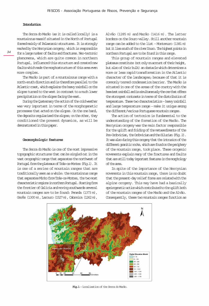
The Serra do Marão is one of the most impressivetopographic structures that can be singled out in thevast orographic range that separates the northwest ofPortugal from the plateaux of Trás-os-Montes (Fig.1). Itis one of a series of mountain ranges that aretraditionally seen as a whole: the mountainous rangethat separates Minho from Trás-os-Montes, the two mostcharacteristic regions in northern Portugal. Starting fromthe frontier of Galicia and moving southwards severalmountain ranges are to be found: Peneda (1373 m),Gerês (1300 m), Larouco (1527 m), Cabreira (1262 m),
Alvão (1285 m) and Marão (1416 m). The latterborders on the Douro valley. Still another mountainrange can be added to the list – Montemuro (1381 m)but it lies south of the river Douro. The highest points innorthern Portugal are to be found in this range.
This group of mountain ranges and elevatedplateaux constitute (not only on account of their height,but also of their bulk) an obstacle which determines amore or less rapid transformation in the Atlanticcharacter of the landscapes; because of that it iscommonly termed condensation barrier. The Marão issituated in one of the areas of the country with theheaviest rainfall and is simultaneously the one that offersthe strongest contrasts in terms of the distribution oftemperature. These two characteristics – heavy rainfalland large temperature range – make it unique amongthe different/various Portuguese mountain ranges.
The action of tectonics is fundamental to theunderstanding of the formation of the Marão. TheHercynian orogeny was the main factor responsiblefor the uplift and folding of the metasediments of thePre-Ordovician, the Ordovician and the Silurian (Fig. 2).It was also during this orogeny that the intrusion of thedifferent granitic rocks, which are found on the peripheryof the mountain range, took place. These orogenicmovements explain many of the fractures and faultsthat are still today important features in the morphologyof the area.
In spite of the importance of the Hercynianmovements in this mountain range, there is no doubtthat the present-day relief forms are related with thealpine orogeny. This may have had a basicallyepeirogenetic action which contributed to the uplift bothof the mountain ranges of the Marão and the Alvão.Consequently, these two mountain ranges function as
Fig.1 - Localisation of the Serra do Marão.

territorium 14
35
a horst both in relation to the group of tectonicdepressions where the river Corgo flows and also tothe graben of the river Tâmega. In fact, the effects of theorogeny are still to be felt and the neo-tectonics goeson acting on the present relief forms (PEDROSA, A., 1993,1994). That is, tectonic action continues to transformthem; thus it is a permanent risk that must be taken intoaccount, notably when building infrastructures such asroads, railways, dams and even houses.
Lithology is another important science that canexplain some relief forms that are found in the Marão.The different granitic rocks, for example, areresponsible for the great number of alveoli that existthere. No matter what their form and size are or theheight at which they may be found, they areundoubtedly related to the different types of granite.They also account for a series of microforms such astors, block chaos, “vascas”, “caneluras” which areclearly connected with the physical, chemical andmineralogical characteristics of these rocks.
The quartzite is a type of rock that has a specialimportance in the morphology of the Marão (PEDROSA,1993) in spite of being quite often found in the upperparts of its slopes. They are almost always foundhalfway up the slopes, which can be explained by theaction of tectonics. Nevertheless, although this type ofquartzite outcropping is more exposed to erosiveprocesses due to its situation, it undoubtedly contributesto the fact that though the inclination of the slopes isalways steep the erosion acts more slowly.
In the schist areas there are several depressions oftectonic origin, but the fundamental characteristic is inthis case the regulation of the slopes by deposits relatedto morphogenetic processes which took place in the
recent Quaternary and which were caused by thefreeze/thaw action. As such, they correspond to colderclimates, which are responsible for a very rapidevolution of the slopes (Photo1).
Origin of the deposits
The effects of the different morphogenetic processeswhich happened in the past can only be inferred fromvestiges that are still observable nowadays: the slopedeposits. It is not always easy to interpret them. Manyhave been destroyed, thus proving the existence of apowerful morphogenetic action which is related tocolder climates in the course of the Quaternary.
The deposits which were found are importantevidence of the evolution of the slopes, not only at ahigh altitude (PEDROSA, A.,1994a) but also in areas atlow altitude in places near the coast (PEDROSA, A.,1989,1994c; REBELO, F. & PEDROSA, A.,1993).
Fig. 2 – Geological sketch map of the Serra do Marão.
Photo 1 - Schist slope regularised by Quaternary deposits.

RISCOS - Associação Portuguesa de Riscos, Prevenção e Segurança
36
The climate must then have been much moreunstable than it is now with temperatures that madegelifraction in situ possible, above all in higher placeswhere vegetation was scarce or non-existent.
The material must have been made transportedalong the slopes by gelifluction associated with a cold,dry climate (DAVEAU, S., 1973; REBELO, F. 1986; CORDEIRO,A. R., 1986a; PEDROSA, A., 1993, 1994a); it is possibleto observe the existence of coiffes (VALADAS, B., 1984).Nevertheless, the above mentioned movement must nothave been carried out only by the action of ice but alsoby means of more or less generalised solifluctions oreven by debris flows and sheet floods. The existence ofpalaeogullies may lead to the conclusion that therewere larger quantities of water, at least during part ofthe year; this would make possible the formation ofgullies in the materials accumulated at the foot of theslopes by other morphogenetic processes.
Thus, the accumulation of materials along theslopes would have been necessary for the formation ofsuch palaeogullies but the morphogenetic processescould have been different. Absolutely necessary fortheir formation was, however, the alternation of drier,colder periods with others which were damper andhypothetically less cold (PEDROSA, A.,1993).
The palaeosols found seem to indicate climaticfluctuations during which the existence of colderclimates, hypothetically drier, contrasted with periodsof higher biostasis which might mean that there werehigher quantities of rainfall and/or milder temperatures.
The oldest deposit found in the Marão is prior to28000 BP; it was possible to find a palaeosol thatfossilises it dating back to 28440 +/- 490 BP. It maycorrespond to the so called Würm II (PEDROSA, A.,1993).It is a deposit with heterometric characteristics,probably the result of the deposition of materialtransported by debris flow, although the possibility ofits having resulted from glacial action is not to be putaside (Fig. 3).
After the deposition of the materials that form thatdeposit, the climate may have evolved; it may havebecome moister and the temperatures milder. This mayhave been responsible for the pedogenesis and theappearance of the above mentioned paleosoil. Theclimate must have become slightly warmer incomparison with the prior phase; this fact gave way tothe pedogenesis and the colonisation of the slopes byvegetation, making them reach a dynamic equilibrium.
Later on the climate must have turned cooler, whichled to the formation of new slope deposits whichfossilised the palaeosoil. Due to the disappearance ofthe vegetation, the slopes must have been more exposedto the action of fragmentation by the action of ice. Theanalysis of the deposits allows the observer to concludethat the morphogenetic processes must have been notonly mass movements of the solifluction type but alsodebris flows. And again comes a period of pedogenesiswhich dates back to around 21340 +/- 350 BP.
The next phase corresponds to the influence of the“Upper Würmian Full Glaciation” (Pleniglaciarsuperior Würmiano), the last glacial stage of thePleistocene. This phase was extremely important in theevolution of the slopes in northern Portugal. In fact,there is a large number of slope deposits whose originis to be found in this period (Photo 2). The climate musthave been cold and relatively dry because it isresponsible for the gelifraction of the rocks (DAVEAU, S.,1973; REBELO, F., 1986; CORDEIRO, A. R.,1986b; REBELO,F., & PEDROSA, A., 1993).
The analysis of these deposits demonstrated thatthe main process of transportation along the slopeswas the action of the ice – gelifluxion, further provedby the existence of coiffes (VALADAS, 1984). Otherprocesses such as the action of gravity are, however,not to be ignored. The study of the stratified slopedeposits does not exclude the possibility of othermovements such as debris flows at least in some partsof the slopes.
Fig. 3 – Stratigraphic column of the superficial formations inthe area of the Serra do Marão.
Photo 2 – Stratified slope deposit near Campanhó, where it ispossible to observe paleogullies.

territorium 14
37
With the beginning of the Tardiglacial (CORDEIRO,A. R.,1990) the climate must have become warmer andthe rainfall heavier, which must have altered themorphogenetic processes; now the most common arethose connected with the runoff and fluvial dynamicsinstead of those related to the action of the ice.
Parallel to the significant movement of materialswhich occurred in this period there was an extensivemovement of materials resulting from priormorphogenetic processes transported more by fluvialaction than by the action of the ice and solifluctions inperiods of thawing. (PEDROSA, A.,1993). Theycontributed to the filling of the bottoms of small valleysand the regularisation of a large part of the slopes(REBELO, F., 1975; REBELO, F. & PEDROSA, A., 1993; PEDROSA,A., 1988, 1993).
However, the climate warming verified at thebeginning of the Tardiglacial cannot have been linear(COUDE-GAUSSEN, G.,1981; FERREIRA, A. B., 1985; Rebelo,F., 1985, 1986; CUNHA, L., 1988; CORDEIRO, A. R.,1986a, 1988).Today the existence of at least threemoments in the last Tardiglacial are recognised (NONN,1966; GUILLEN, 1962; DAVEAU, 1973, 1978), with aninterphase and a recurrence of a very cold, dry phase(JORDA, 1980; GARMENDIA, 1989; VLIET-LANOE, 1988). Infact, it seems that the Tardiglacial is characterised bythe existence of several climatic fluctuations (CORDEIRO,1990; Pedrosa, A., 1994c); MARTINS, 1999), confirmedby the features of the formation of Covelo do Monte.About 11000 BP a new climatic crisis must haveoccurred (CORDEIRO, A. R. , 1990; GULLIEN et al., 1978;GARMENDIA, 1984); it would have led not only to theoccurrence of processes related to the action of the icebut also to generalised solifluctions which may havecaused the remixing of deposits formed by priorprocesses.
It is possible to find a great heterogeneity in theTardiglacial deposits, which depends on the exposureof the slopes, on their rock substratum and on theirinclination (PEDROSA, A., 1994b; MARTINS, 1999); butthe fundamental factor must have been the snowfallduring a part of the year and its thawing in the warmerperiod, which was probably the time of the heaviestrainfall. The most important processes must have beenthe solifluctions which were responsible for theregularisation of a great part of the slopes as well asthe occurrence of slides especially extensive debrisflows, whose marks can still be traced on the bottomsof the valleys (Photo 3).
However, it is not possible to find mature soils; themajority are entisols and are quickly affected by smallclimatic changes. A new warming seems to havereached its peak by 8000 BP as it was possible to findin the Marão some palaeosols which are contemporarywith this period known as Holocene climatic optimum.
Around 5000 BP when the sub-Boreal period began(GOUDIE, 1979) an increase in erosion must have takenplace; this increase is probably connected with a dropin temperature as well as with some human activities,especially the burning of land to renew the vegetationand obtain new pastureland, which would increasethe power of such erosion processes as runoff andsplash (PEDROSA, A., 1993). Solifluctions must also haveoccurred in some parts of the slopes, above all in higherplaces facing north. In the Marão the best example ofthis period is the formation of Lameira.
Gravity slumping associated with a massivecongelifraction of rocks may correspond to differentgenerations of these forms or, at least, to the existenceof different periods which activated their formation andevolution. In the Marão they are generally found atheights superior to 700m and are sometimes associatedwith steep inclines, especially on shady slopes. Animportant phase in the origin of these forms may havebeen the short glacial age, which occurred in the 17thand 18th centuries (LADURIE, 1983). This process is stillactive nowadays in places situated on shady slopeswhere the bare rock appears on the surface withoutany soil or vegetation covering it (PEDROSA, A.,1993).
The importance of slope deposits for the presentslope morphodynamics
The geomorphologic dynamics of the mountainranges of northern Portugal is very complex since boththe factors and the intervening agents as well as theirinteraction are diverse. Even if only the natural agentsare taken into account, there is still the interaction ofseveral factors whose relative importance varies fromregion to region or even from place to place, makingthe active morphogenetic processes different. It isindispensable to understand the behaviour of thefundamental climatic elements – precipitation andtemperature – to explain the action of the processeswhich are responsible for the present evolution of theslopes, but it is also necessary to take into accountfactors such as the lithology, the morphology, thebiogeography and the surface formations.
Photo 3 – Tardiglacial deposit regularising great part of theslopes of the Serra do Marão.

RISCOS - Associação Portuguesa de Riscos, Prevenção e Segurança
38
The importance of the formation of gullies
In these areas the formation of gullies is clearlyconditioned by the existence of a slope deposit, whichworks as a regulator because there are no trees orquite often because man has acted on this terrain.
The examples that will now be given show clearlywhat has just been said.
In July 1992, on a slope near the village of Paradelado Monte (municipality of Santa Marta de Penaguião)there was a very heavy shower. Unfortunately, it is notrecorded, owing to the small geographic extension ofthe area on which it rained and the non-existence ofpluviometres, but it is estimated to have reached valuesvery nearly 30 mm while it lasted (about 1 hour); inconsequence, two big gullies appeared (Photo 4).
slope (30º), the growth of new vegetation is ratherslow. The whole slope is regularised by a deposit whichin some places is more than 2 meters thick. More orless in the middle of the slope two tracks were openedon the slopes to lay a system of waterpipes. This wasthe background in which the slope gullying began. Atfirst the runoff flowed along one of the tracks andformed gullies. Later the drainage stopped flowingalong the tracks, turned in the direction of the steeperincline and formed two gullies whose depth is clearlyconditioned by the depth of the deposit whichregularises the slope. As soon as the water reachedthe schists in situ the gully thalweg could not becomedeeper; it became wider and the water transported theslope material which was not well consolidated. Oneof them deepened a pre-existing gully while the otherdeveloped at first parallel to a small valley that existedon the slope, later using only its final part; as aconsequence, its thalweg became deeper.
In order to calculate the quantity of materialtransported, the length, the width and depth of the twogullies, they were measured in different sections. Theresults of these measurements were as follows: in oneof the gullies the volume of material transported wasabout 465 m3 while in the other it was a bit more:about 570 m3 (Chart 1). All this material must havebeen transported only in the short period of time duringwhich the rain poured down; one of the gullies has acone of dejection just above the road (Photo 5), formedby the coarser materials, while the material transportedby the other crossed the road and ran down the slopeinto the main brook.
Photo 4 – Gullying in the area of Paradela do Monte.
In July 1991 there had been a fire which hadcompletely destroyed the vegetation covering thatslope. Due to the altitude and the inclination of theslope (30º), the growth of new vegetation is ratherslow. The whole slope is regularised by a deposit whichin some places is more than 2 meters thick. More orless in the middle of the slope two tracks were openedon the slopes to lay a system of waterpipes. This wasthe background in which the slope gullying began. Atfirst the runoff flowed along one of the tracks andformed gullies. Later the drainage stopped flowingalong the tracks, turned in the direction of the steeperincline and formed two gullies whose depth is clearlyconditioned by the depth of the deposit whichregularises the slope. As soon as the water reachedthe schists in situ the gully thalweg could not becomedeeper; it became wider and the water transported theslope material which was not well consolidated. Oneof them deepened a pre-existing gully while the otherdeveloped at first parallel to a small valley that existedon the slope, later using only its final part; as aconsequence, its thalweg became deeper.
In July 1991 there had been a fire which hadcompletely destroyed the vegetation covering thatslope. Due to the altitude and the inclination of the
Chart 1- Dimension and Volume of material transported bythe gullies.
Photo 5 – Detail of the material deposited in the slopeafter gullying.
LengthVolume of transported
material
max. min. max. min.
(m) (m) (m) (m)
Gully 1 160,7 2,6 0,3 2,5 0,1 465,8
Gully 1 120,9 7,7 1 3 0,8 570,2
(m) (m3)
Width Depth

territorium 14
39
The importance of mass movements
Mass movements can have a greater or smallercomplexity because they can be the result of differentprocesses which can only be identified by an analysisof each individual case. Roughly speaking, they cango from the moving of small individual particles to thefall of big stones and slow or fast flows.
However, these movements cannot be explainedonly by adverse meteorological conditions, as neitherheavy rainfalls nor all the long periods of precipitationalways give rise to soil movements. Therefore, it isnecessary to look for other factors which acting togethermake it possible to explain the onset of the initialmovement which causes the earth-flow .
In several recent studies different authors (REBELO,2001; PEDROSA, 1993, 1994a, 1994b, 2001; PEDROSA,LOURENÇO, FELGUEIRAS, 2001; PEDROSA, MARTINS, 2001;PEDROSA, BATEIRA, SOARES,1995; PEDROSA, MARQUES,1994) have tried to systematise the factors that are ofgreater importance for the onset of these processes innorthern Portugal. Natural factors that can influencethe occurrence of debris flows and mass movementshave been considered up to this moment. Nevertheless,factors related to human interference are more andmore frequent. Some are connected with the subdividingof estates into plots for the building of houses, otherswith the building of roads and railways which implyextensive back filling (aterro) and excavation(desaterro) of land; these alter the conditions ofequilibrium on the slope and are responsible for theoccurrence or, at least, for starting the initial process.
Humankind has been a geomorphological agentfor a long time and in this role is becoming more andmore important. Human influence creates “humanisedlandscapes” which do not always safeguard theoperation of the natural processes and thus contributeto situations which, left to nature, might eventuallyhappen but much, much later.
It is unquestionable that many of these movements(not only the individualised ones such as landslides,earth falls, mudflows, and so on, but also those that acttogether) almost always happen after periods of heavyrainfall which leave the soil, the alteration mantles(mantos de alteração) and the slope deposits saturatedor near saturation, so creating conditions to initiate theearth flow.
Besides, the infiltration resulting from the rainwateractivates the underground circulation which sometimesrespects former palaeotopographies, i. e., former smallriver valleys fossilised by slope deposits. The watermanages to trickle between the rock, little or not altered,and the overlying deposits. When these undergroundflows are strong and are associated with the waterinfiltrated directly from the rainfall, they can contributeto the fluidity of the overlying deposits and, in doing
so, to create conditions for their starting a movementwhich often extends downstream through flowscontaining a higher or smaller quantity of mud.
Besides the hydroclimatic conditions, structuralaspects both lithological and tectonic are sometimesfundamental factors, often playing an important partin that they condition the type of movement, its size andthe evolution of the area affected.
Quite often it is the net of faults and fractures thatcontributes to facilitate the alteration of the rocks andallows a more efficient infiltration of water whichreaches progressively deeper levels and ends up bymaking the surface mass movements easier.
The geomorphological factors are the most variedand those that have more significant repercussionswhen connected with other factors – natural and human.
The steepness of the slope is another morphologicalfactor of great importance for the onset of massmovements. The above mentioned authors speak of steepinclines almost always superior to 30% as being oneof the morphological factors decisive for the fastevolution of the slopes and it is one of the criteria thatmay provide important elements for the definition ofareas of potential risk.
Breaks in the slope, above all when they contributeto the increase of the incline downstream, are a localfactor responsible for the worsening of the conditionsof the occurrence of movements; because of that, theydeserve a special reference.
Besides the incline, the form of the slope also playsan important part in the creation of conditions favourableto the development of processes of slope evolution.
Slope regulation by surface formations isundoubtedly one of the factors that may contribute in amore decisive way to the development of these massmovements, which according to their characteristicscan lead to movements sometimes slow sometimes fast.Thus, when the surface formation corresponds to deepalteration mantles, capable of absorbing largequantities of water, it can lead to extensive massmovements. In fact, the great thickness of the alterationmantle or of the deposit favours the water infiltration;the saturation point can then be reached and the soilmay begin to collapse. The great absorption powermay slow down the beginning of the movement andbring about its development in stages over the courseof several days.
Another frequent situation has to do with the thinslope deposits of the Quaternary, rich in argillaceousmaterial with a great capacity to absorb water, lyingon rocks which are little altered and which quite oftenact as an efficient sliding surface. In the schist andquartzite areas of the mountain ranges in northernPortugal, this is one of the most efficient natural

RISCOS - Associação Portuguesa de Riscos, Prevenção e Segurança
40
processes of slope evolution. In fact, when heavy rainfalls for long periods of time on steep slopes regularisedby slope deposits, mass movements such as debrisflows happen frequently.
Debris flows in the Serra do Marão
Debris flows are a frequent occurrence on theslopes of the Marão. They are related to the quantity ofrainfall, the steep inclination of the slopes and aboveall to the regularisation of the schist slopes by thedeposits of the Quaternary which have already beenmentioned in the first part of this paper. In fact, it is onthe discontinuity surface which coincides with thecontact between the slope deposits and the bedrockthat the failure occurs and the debris flow begins.
In fact, surface formations constituted by the slopedeposits of the Quaternary allow the infiltration of therainwater that then flows through the deposit materialsbut above all in the surface of contact between themand the metasedimentary rocks, which owing to theirimpermeability, lead to the accumulation and flow ofthe infiltrated water. Thus, when the period of rainfall islong, the fluidity of the overlying deposits may increase,causing the rupture.
In 1992 several debris flows occurred inconsequence of a long period of precipitation (A.Pedrosa, 1993); they happened near the villages ofMontes e Póvoa da Serra, whose slopes are steepand covered with trees; but the fundamental reasonwas the fact that they were regularised by deposits(Photos 6 and 7).
Later, in 1997, after a few very rainy days, somemore debris flows occurred in slopes with the samecharacteristics as those already described. This is thecase of Portal da Freita (Photo 8) and of Carvalhadade Baixo (Photo 9) both near the village of Montes.
Again in 2001, after a long period of rainfall, therewere debris flows down several slopes; all of them hadthe same characteristics: a steep inclination and thepresence of a surface formation with a thickness of 1.5 / 2metres which regularises the slopes. In that same year,besides the occurrence of debris flows in new places,there were also new movements in the locations ofprevious flows, such as the ones in Póvoa da Serra orin Montes.
Photo 6 – Characteristics of the debris flow of Póvoa da Serra.
Photo 7 – Another detail of the debris flow in Póvoa da Serra.
Photo 9 – Debris flow in Carvalhal de Baixo where it ispossible to observe that the place of the flow began coincides
with slope are regularised by deposit.
Photo 8 – Detail of the place where the debris flow of Portalda Freita began, whose failure is clearly related with the
contact of the deposit with the bedrock.

territorium 14
41
The one that had the most serious consequenceshappened place near Mesão Frio (Volta Grande)(Photo 10). It reached road no N101 (Amarante –Peso da Régua), dragging two cars that were drivingalong it and causing the death of one of the drivers.This example shows clearly the risk of building roadson the foot of slopes with the characteristics that havebeen described because processes of rapid change inthe characteristics of the slopes often occur in thesecircumstances, leading to a greater instability of theregolith materials that regularise the slope.
one goes from steeper slopes to gentler ones, onemay observe the deceleration of the erosionprocesses in favour of processes of accumulation ofmaterials (YOUNG, 1969).
Slope inclinations have great influence on thedynamics of any present-day morphogenetic process;therefore, it is an ever present factor in the analysis andunderstanding of the morphogenetic processes andtheir action.
On the slopes on which these flows occurred themean inclination varies between 30º and 40º which isan important element in the onset of the whole process.In some places the gradient is even higher: for example,near Póvoa da Serra the mean slope inclination is over40º. However, near the scars in the place where thedebris flow began the angle is over 60º.
But on the slopes of the Marão it is the fact that theyare regularised by slope deposits that are very differentin size that facilitates the infiltration of rainwater evenon steep slopes. The water reaches quickly the planeof contact with the bedrock, which is relativelyimpermeable. That is where the rupture occurs whichallows the debris flow to begin.
The study of the present morphogenetic processesmay contribute to knowledge about the natural hazards(MARTIN, 1987; REBELO, 1991b, 1994; BRYANT, 1991).Knowing the elements that interact on the slopes isfundamental; they must be understood from a dynamicpoint of view, distinguishing between the major andthe minor factors.
The geomorphologist must know as deeply aspossible the combinations and ways in which thesefactors act. But although it is possible to map areaswhere landslides may take place, the forecast of theoccurrence of such phenomena is based merely on aprobability and not on a precise indication both intime and in space.
However, the study of a growing number of casesrelated to specific morphogenetic processes makes itpossible to get a deeper insight into the way theseprocesses operate, which will enable the authorities tomitigate their harmful consequences, to establish ascale of risks and draw maps showing the vulnerableareas in the landscape.
Bibliography
BRYANT, E.A. (1991) - Natural Hazards, University Press,Cambridge.
CORDEIRO, A. R. (1986a) - Evolução das vertentes naSerra da Freita, dissertação no âmbito das provas deAptidão Pedagógica e Capacidade Científica àFaculdade de Letras da Universidade de Coimbra,Coimbra, (policopiado).
Photo 10 – Location of the occurrence of the debris flow of Volta Grande which affected road N101 and dragged two
cars causing one death among the car occupants.
Conclusion
The behaviour of climatic elements is important forthe understanding of the morphogenetic processes. Theanalysis of such elements cannot confine itself to themean values because it is important to know theirvariation, not only during one year but also over alarger number of years, especially on account of theconsequences that that variation may have on themorphogenetic processes (REBELO, 1983; BRYANT,1991;FAUGÈRES, 1991).
Mass movements do not always coincide with theday of the heaviest rainfall; quite often they occur ondays on which the precipitation is scarce or even non-existent. So it is indispensable to observe thepluviometric values of periods further from the day onwhich the movement occurred. Although there may bea relationship between the occurrence of very heavyrainfall and the occurrence of movements theprolonging of heavy rain over many days causes soilsaturation (FLAGEOLLET, 1989). Thus, in areas with largequantities of argillaceous material the relationship ofheavy rainfall to earthflow movement is not so direct,because its water absorption capacity is very high,which retards the occurrence of the slip.
Another important factor in the dynamics of themorphogenetic processes is morphology. Thus, when

RISCOS - Associação Portuguesa de Riscos, Prevenção e Segurança
42
CORDEIRO, A. R. (1986b) - “Nota preliminar sobre asformas e formações periglaciares na Serra da Freita”,Cadernos de Geografia, 5, Coimbra, p. 161-172.
CORDEIRO, A. R. (1988) - “Evolução das vertentes daSerra da Freita no Quaternário recente”, Cadernos deGeografia, 7, Coimbra, p. 87-133.
CORDEIRO, A. R. (1990) - “O depósito de Varzielas (Serrado Caramulo): contribuição para o estudo doTardiglaciar Würmiano em Portugal”, Cadernos deGeografia, 9, Coimbra, p. 49-60.
COUDÉ - GAUSSEN, G. (1981) - “Les Serras de Peneda etdo Gerês: Étude de géomorphologie”, Memórias doC.E.G., 5, Lisboa.
CUNHA, L. (1988) - “As Serras Calcárias de Condeixa-Sicó-Alvaiázere. Estudo de Geomorfologia”,Dissertação de Doutoramento, Faculdade de Letrasda Universidade de Coimbra, Coimbra.
DAVEAU, S. (1973) - “Quelques exemples d’évolutionquaternaire des versants au Portugal”, Finisterra, 15(VIII): p. 5-47, C.E.G., Lisboa.
DAVEAU, S. (1978) - Le périglaciaire d’altitude auPortugal, Colloque sur le périglaciaire d’altitude dudomaine méditerranéen et abords, AssociationGéographoque d’Álsace, Strasbourg, p.63-78.
FAUGÉRES, L. (1991) - “La géo-cindynique, Géo-sciencedu risque”, Bull. Assoc. Géographes Françaises, nº3,Paris, p.179-193.
FLAGEOLLET, Jean-Claude (1989) – Les mouvements deterrain et leur prévention, Masson, Paris.
GARMENDIA, M. C. P. (1988) - “Dynamique de vegetationtardiglaciaire et holocene du Centre-Nord de l’Espagned’après l’analyse pollinique”, Thése en Sciences, spéc.Paleoécologie, de l’Université d’Aix-Marseille III.
GOUDIE, A. (1979) – Environmental Change, ClarendonPress, Oxford.
GUILLEN, Y. (1962) – “Néoglaciaire et Tardiglaciaire:Géochimie, Palynologie, Préhistoire”, Annales deGeographie, 383 (LXXI), p. 1-35.
GUILLEN, Y. et al. (1978) - “Les climats et les hommes enEurope et en Afrique septentrional de 28 000 BP à 10000 BP”, Bull. Assoc. Fr. Etud. Quatern., 4 (15), p. 187-193.
JORDA, M. (1980) - Morphogenèse et évolution despaysages dans les Alpes de Haute Provence depuis leTardiglaciaire: facteurs naturels et facteursanthropiques, Bull. Assoc. Géog. Fr., p. 75-81.
LADURIE, E. Le Roy (1983) - Histoire du climat depuisl’an mil, Flammarion, Paris.
MARTIN, J. (1987) - “Les risques natureis au Maroc:reflections preliminaires, Hommage a Gerard Maurer-Les milieux et les hommes dans les paysmediterranéenms”, fasc 11, Études mediterranéens,Centre Interuniversitaire d’études Mediterranéens,Poitiers, p. 275-290.
MARTINS, Bruno (1999) - Estudo das formaçõessuperficiais na vertente norte da Serra do Alvão –Contributo para o seu conhecimento geomorfológico,IICT, ed. Autor, 101 pp, Lisboa.
NONN, H. (1966) – “Les regions côtières de la Galice(Espagne): Étude geomorphologique”, Thése Lettres,Pub. Fac. Lettres, Unv. Strasbourg, Strasbourg.
PEDROSA, A. S. (1989) - “A Importância do Frio naEvolução das Vertentes na área de S. Miguel-o-Anjo”,Cadernos de Geografia, nº 8, IEG, Coimbra, 1989p. 199-207.
PEDROSA, A. S. (1993) – Serra do Marão: Estudo degeomorfologia, Dissertação de Doutoramento,Faculdade de Letras da Universidade. do Porto, Porto.
PEDROSA, A. S. (1994a) – Contributo para oconhecimento da dinâmca geomorfológica das serrasdo Norte de Portugal. O exemplo da serra do Marão,Rurália, Arouca, p. 69-90.
PEDROSA, A. S. (1994b) – “As actividades humanas eos processos morfológicos. O exemplo da Serra doMarão”, Territorium, Coimbra, p. 23-34.PEDROSA, A. S. (1994c) - “O Periglaciar no Norte dePortugal: O estado actual dos conhecimentos,Periglaciarismo en la Península Ibérica, Canaria yBaleares”, Granada, p. 55 - 73.
PEDROSA, A. (2001) - “Movimentos em massa eordenamento do território”, in Actas do II Semináriosobre Recursos Naturais, Ambiente e Ordenamentodo Território, Vila Real , CF-7-11.
PEDROSA, A.; MARQUES, B. Serpa (1994 ) - “Man's actionand slope erosion: A case study in Tâmega Basin(1981)”, Territorium, 1, Coimbra, p. 23-34.

territorium 14
43
PEDROSA, A. S. et. al. (1995) – “Covelo do Gerês:Contribuição para o estudo dos movimentos de massano Norte de Portugal”, Territorium, 2, Coimbra, p.21-32.
PEDROSA, A. S. et. al. (2001) – Metodologia para oestudo dos ravinamentos, Metodologias de Estudo deProcessos de Erosão, FLUP, Porto, p. 85-98.
PEDROSA, A. S.; LOURENÇO, L.; FELGUEIRAS, J. (2001) -“Movimentos em massa: exemplos ocorridos no Nortede Portugal”, Revista Técnica e Formativa da EscolaNacional de Bombeiros, Ano 5, nº 17, p. 25-39.
PEDROSA, A; MARTINS, Bruno (2001) - “Os movimentosem massa e os depósitos de vertente em áreasmetassedimentares: alguns exemplos no Norte dePortugal”, in Actas do II Seminário sobre RecursosNaturais, Ambiente e Ordenamento do Território, VilaReal, CO-161-169.
REBELO, F. (1975) - “Serras de Valongo: estudo deGeomorfologia”, Suplementos de Biblos, 9, Coimbra.
REBELO, Fernando (1985) - "História e Geografia Física- Reflexões em torno de um caso de interdisciplinaridadedesenvolvido por Jaime Cortesão". Cidadania eHistória, Revista de História Económica e Social, 6-7,Lisboa, Sá da Costa, p. 103-110.
REBELO, F. (1986) - “Modelado periglaciar de baixaaltitude em Portugal”, Cadernos de Geografia, 5,Coimbra, p. 127-137.
REBELO, F. (1991) – “Geografia Física e Riscos naturais:alguns exemplos de riscos geomorfologicos emvertentes e arribas no domínio mediterrânico”, Biblos,LXVII, Coimbra, p. 353-371.
REBELO, F. (1994) – “Do ordenamento do território àgestão dos riscos naturais. A importância da GeografiaFísica salientada através de casos seleccionados emPortugal”, Territorium, Coimbra, p. 7-15.
REBELO, F. (2001) – Riscos naturais e acção antrópica,Imprensa da Universidade, Coimbra.
REBELO, F; PEDROSA, A. (1993) - “Novas observaçõessobre depósitos relacionados com o frio na área deValongo - S. Miguel-o-Anjo”, El Cuaternario en Espanay Portugal, volume II, Madrid, p. 501-504.
VLIET-LANOE, B. (1988) - Le role de la glace de ségrégationdans les formations superficielles de l’Europe de l’Ouest.Processus et héritages. Thèses de Doctorat d’Etat Mens.Géographie, Univ. Paris I, tome 1 et 2, Caen, 854 pp.
VALADAS, Bernard (1984) - Les hautes terres du massifCentral Fançais. Contribution à l’étude desmorphodynamiques récentes sur versants cristallins etvolcaniques, Vol. I, II, Université de Paris I, Paris.