Embed Size (px)
Citation preview

Environment of the Yukon
G.G.E. SCUDDER
Department of Zoology, University of British Columbia6270 University Blvd., Vancouver, British Columbia V6T 1Z4
Abstract. The Yukon Territory, situated in the northwest corner of Canada adjacent to Alaska, and north of 60°,has a rugged and complex physiography and geology, dominated by mountainous terrain. There are five majorwatersheds, several large rivers, and many smaller, rich river valleys. The area has innumerable small ponds anddamp depressions, but few large lakes. Yukon climate is typified by long, cold winters and short, warm summers.The Yukon has the most variable climate in North America, and across the Territory nine distinct climatic regionscan be recognized. Most of the Yukon has either permanent, discontinuous or scattered permafrost. Cryosolic soilsdominate in the northern permanent permafrost areas, whereas Brunisolic soils occur in the south where there isdiscontinuous or scattered permafrost.
The dominant vegetation types in the Yukon are arctic tundra, alpine tundra, taiga or subarctic forest, borealforest and subalpine-shrub forest. Arctic tundra and taiga prevail in the northern part of the Territory, whereas theboreal forest and subalpine-shrub forest characterize the southern part. Alpine tundra occurs at higher elevationsthroughout the Territory. Five distinct ecozones and 23 ecoregions are now recognized in the Yukon. In addition,scattered throughout the Territory are a number of habitats of special interest to entomologists. These includesprings, peatlands, saline flats, sand dunes, and distinctive xeric sites with Artemisia frigida-grass communities.During the Pleistocene much of the Yukon remained ice-free and was part of Beringia, the largest refugial area inthe north during the last ice age. As such, the Yukon is a central focus of biogeography in the Nearctic region.
Résumé. L’environnement au Yukon. Le territoire du Yukon, situé dans la partie nord-ouest du Canada, juste à côtéde l’Alaska, au nord du 60e parallèle, a une géologie et une physiographie accidentées et complexes et est dominépar les systèmes de montagnes. On y trouve cinq bassins hydrographiques principaux, plusieurs grandes rivières etde nombreuses petites vallées de cours d’eau plus petits. Le terrain est parsemé d’innombrables petits étangs etdépressions humides mais compte peu de grands lacs. Les hivers sont longs et froids, les étés, courts et chauds. LeYukon est soumis aux conditions climatiques les plus variables en Amérique du Nord et neuf régions climatiquesdistinctes peuvent être reconnues. Presque toute la surface du Yukon est recouverte de pergélisol permanent,discontinu ou clairsemé. Les cryosols sont dominants dans les zones de pergélisol permanent du nord, alors que lesbrunisols dominent dans le sud où le pergélisol est discontinu ou clairsemé.
Les principaux types de végétation du Yukon sont ceux de la toundra arctique, de la toundra alpine, de la taïga,ou des forêts subarctique, boréale ou buissonneuse subalpine. La toundra arctique et la taïga dominent dans la partienord du territoire, alors que la forêt boréale et la forêt buissonneuse subalpine caractérisent la partie australe. Latoundra alpine se rencontre en altitude dans tout le territoire. On reconnaît maintenant cinq écozones distinctes et23 écorégions au Yukon. De plus, un grand nombre d’habitats d’intérêt particulier pour les entomologistes seretrouvent un peu partout dans le territoire: sources, tourbières, plateaux salés, dunes de sable, ainsi que denombreuses zones xériques à communautés Artemisia frigida-herbacées. Au cours du Pléistocène, le Yukon estresté en grande partie déglacé et formait une partie de la Béringie, la plus grande zone refuge du nord au cours desdernières glaciations. Le Yukon est donc une zone biogéographique d’intérêt primordial dans la région néarctique.
Introduction
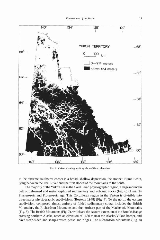
The Yukon Territory occupies an area of 482 681 km2 (Oswald and Senyk 1977) innorthwestern Canada (Fig. 1). It is bounded on the north by the Beaufort Sea. In the westalong 141°W longitude it abuts Alaska, and along 60°N latitude it meets British Columbia.The eastern boundary with the Northwest Territories is an irregular line following the heightof land from about 136°30′W longitude in the north to about 124°W longitude in the south.
The Yukon is a rugged territory of mountains, rough plateaus and valleys. Most of thesouthern three-fifths of the Territory is above 914 metres in elevation (Fig. 2). Only a fewmajor roads traverse the complex terrain (Fig. 3). However, these roads cross the Territoryfrom east to west, and from north to south. In the process they provide access to the major
pp. 13 – 57 in H.V. Danks and J.A. Downes (Eds.), Insects of the Yukon. Biological Survey of Canada (Terrestrial Arthropods),Ottawa. 1034 pp. © 1997

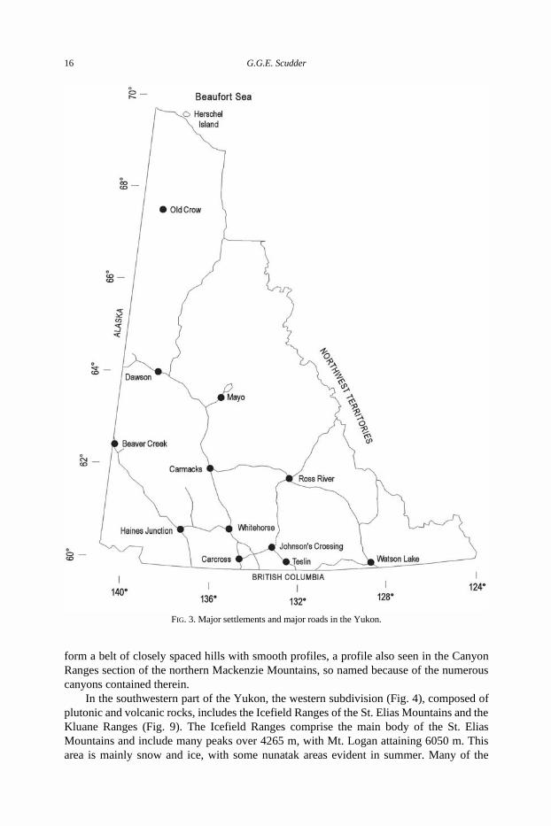
subarctic and boreal ecozones and to more than half of the distinctive ecoregions in theYukon. There are only about 12 major settlements (Fig. 3), with all but one of them in thesouthern half of the Territory and connected by the major roads. The one exception is OldCrow in the north, which can be reached by air.
Physiography and Geology
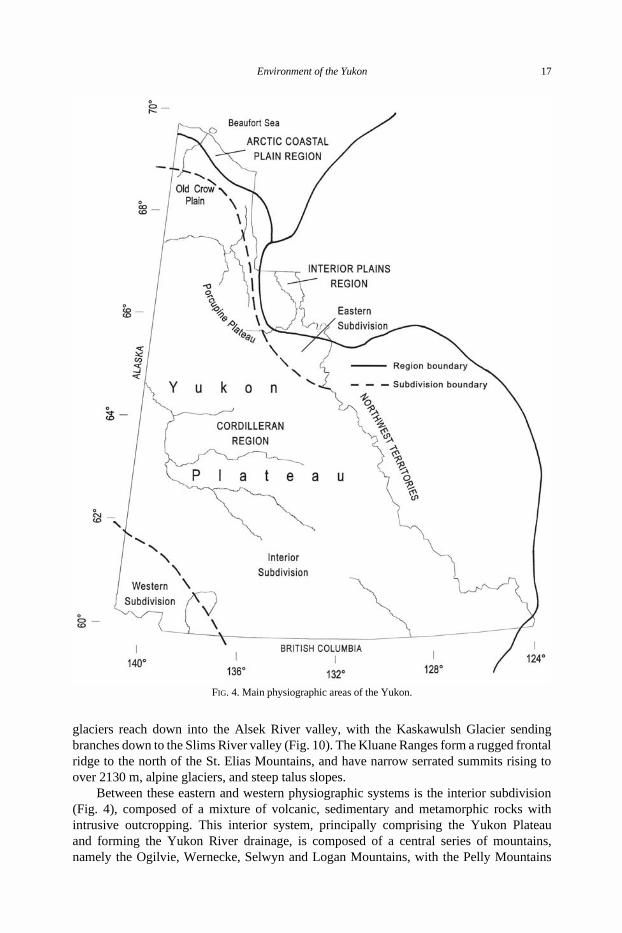
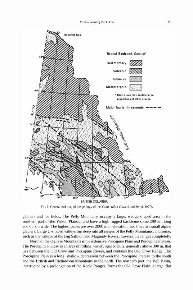
The physiography of the Yukon has been considered by Bostock (1948, 1961, 1970)and Tarnocai et al. (1993). The geology of the Territory is described in detail by Gabrielseand Yorath (1992) and summarized in map form by Clague (1989a). There are three majorphysiographic regions in the Yukon (Fig. 4), which have their own distinctive geology(Fig. 6). The Yukon Coastal Plain is part of the Arctic Coastal Plain physiographic region,and is formed of little-deformed sediments and volcanics, mainly of Mesozoic and Cenozoicages. The Yukon Coastal Plain is a narrow strip of land along the Beaufort Sea, and includesHerschel Island (Fig. 4). The plain, which decreases in elevation to the west, is largely anerosional surface cut into Tertiary sandstone and shale, that is covered with a thin veneer ofrecent sediment. The unglaciated area west of Herschel Island is an almost flat, lacustrineplain, incised by streams and rivers, with the coastal scarp interrupted by alluvial fans andfloodplains at the mouth of the Malcolm River and Firth River (Fig. 13). The glaciated areato the east of Herschel Island, largely covered with late Wisconsinan morainal materials, isspotted with lakes and ponds of thermokarst origin (Rampton 1982).
The northeastern part of the Yukon, which includes the Peel Plateau, is part of theInterior Plains physiographic region, and is formed of thick, flat-lying Phanerozoic strata.The Peel Plateau is a striking and rather even land surface lying between the eastern frontof the Richardson Mountains and the northern front of the Mackenzie Mountains (Fig. 5).
FIG. 1. Geographical reference map for the Yukon.
14 G.G.E. Scudder
In the extreme southwest corner is a broad, shallow depression, the Bonnet Plume Basin,lying between the Peel River and the first slopes of the mountains to the south.
The majority of the Yukon lies in the Cordilleran physiographic region, a large mountainbelt of deformed and metamorphosed sedimentary and volcanic rocks (Fig. 6) of mainlyPhanerozoic and Proterozoic age. This Cordilleran region in the Yukon is divisible intothree major physiographic subdivisions (Bostock 1948) (Fig. 4). To the north, the easternsubdivision, composed almost entirely of folded sedimentary strata, includes the BritishMountains, the Richardson Mountains and the northern part of the Mackenzie Mountains(Fig. 5). The British Mountains (Fig. 7), which are the eastern extension of the Brooks Rangecrossing northern Alaska, reach an elevation of 1680 m near the Alaska/Yukon border, andhave steep-sided and sharp-crested peaks and ridges. The Richardson Mountains (Fig. 8)
FIG. 2. Yukon showing territory above 914 m elevation.
Environment of the Yukon 15
form a belt of closely spaced hills with smooth profiles, a profile also seen in the CanyonRanges section of the northern Mackenzie Mountains, so named because of the numerouscanyons contained therein.
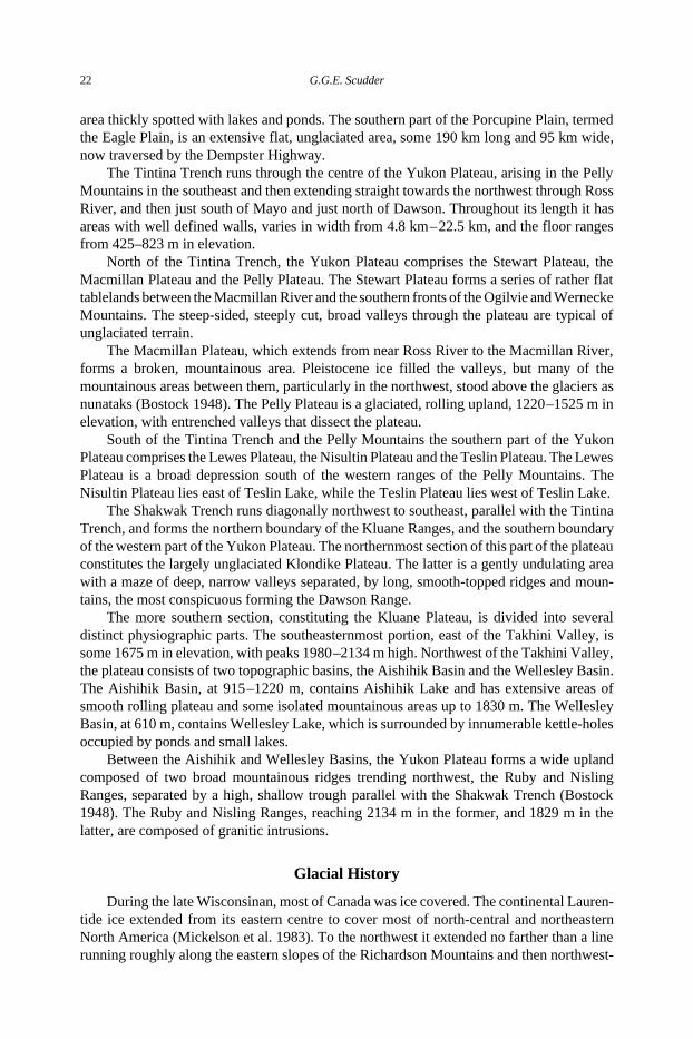
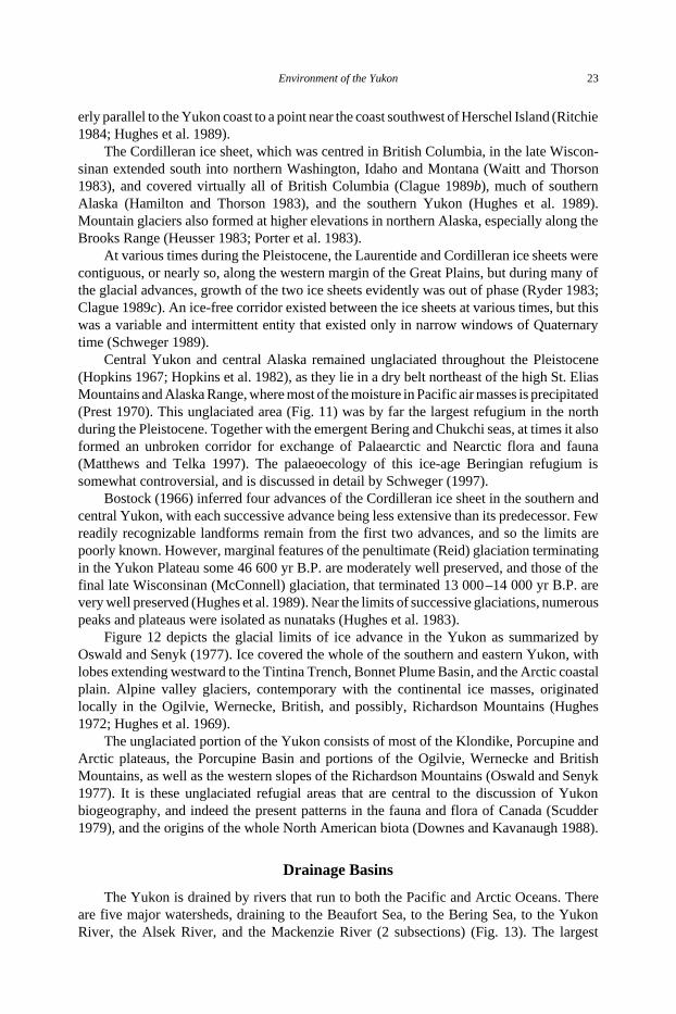
In the southwestern part of the Yukon, the western subdivision (Fig. 4), composed ofplutonic and volcanic rocks, includes the Icefield Ranges of the St. Elias Mountains and theKluane Ranges (Fig. 9). The Icefield Ranges comprise the main body of the St. EliasMountains and include many peaks over 4265 m, with Mt. Logan attaining 6050 m. Thisarea is mainly snow and ice, with some nunatak areas evident in summer. Many of the
FIG. 3. Major settlements and major roads in the Yukon.
16 G.G.E. Scudder
glaciers reach down into the Alsek River valley, with the Kaskawulsh Glacier sendingbranches down to the Slims River valley (Fig. 10). The Kluane Ranges form a rugged frontalridge to the north of the St. Elias Mountains, and have narrow serrated summits rising toover 2130 m, alpine glaciers, and steep talus slopes.
Between these eastern and western physiographic systems is the interior subdivision(Fig. 4), composed of a mixture of volcanic, sedimentary and metamorphic rocks withintrusive outcropping. This interior system, principally comprising the Yukon Plateauand forming the Yukon River drainage, is composed of a central series of mountains,namely the Ogilvie, Wernecke, Selwyn and Logan Mountains, with the Pelly Mountains
FIG. 4. Main physiographic areas of the Yukon.
Environment of the Yukon 17
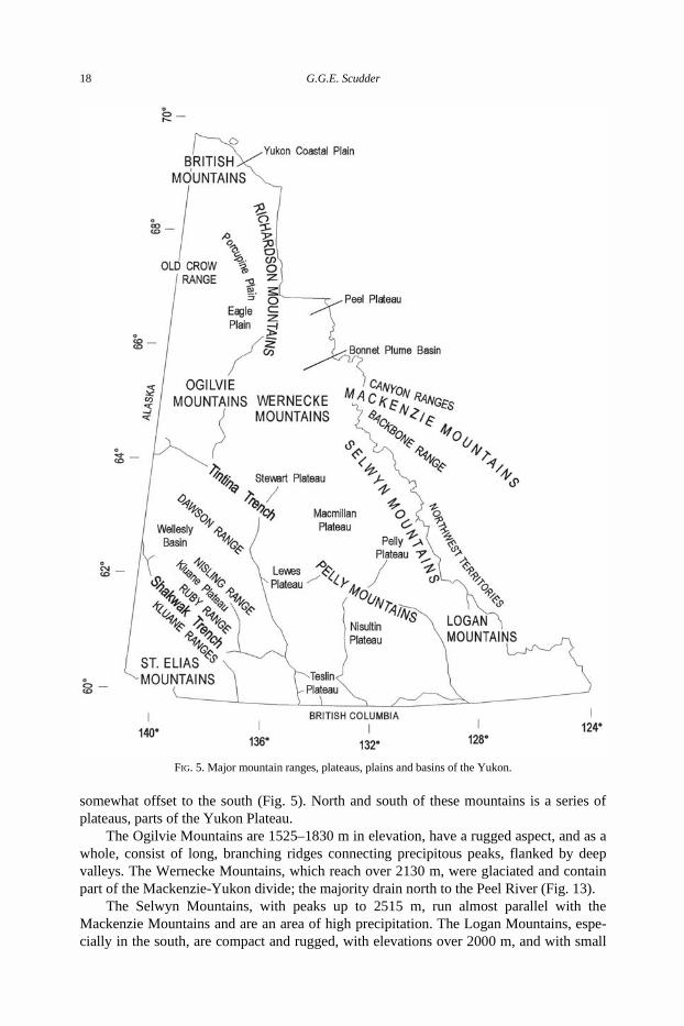
somewhat offset to the south (Fig. 5). North and south of these mountains is a series ofplateaus, parts of the Yukon Plateau.
The Ogilvie Mountains are 1525–1830 m in elevation, have a rugged aspect, and as awhole, consist of long, branching ridges connecting precipitous peaks, flanked by deepvalleys. The Wernecke Mountains, which reach over 2130 m, were glaciated and containpart of the Mackenzie-Yukon divide; the majority drain north to the Peel River (Fig. 13).
The Selwyn Mountains, with peaks up to 2515 m, run almost parallel with theMackenzie Mountains and are an area of high precipitation. The Logan Mountains, espe-cially in the south, are compact and rugged, with elevations over 2000 m, and with small
FIG. 5. Major mountain ranges, plateaus, plains and basins of the Yukon.
18 G.G.E. Scudder
glaciers and ice fields. The Pelly Mountains occupy a large, wedge-shaped area in thesouthern part of the Yukon Plateau, and have a high rugged backbone some 290 km longand 65 km wide. The highest peaks are over 2000 m in elevation, and there are small alpineglaciers. Large U-shaped valleys run deep into all ranges of the Pelly Mountains, and some,such as the valleys of the Big Salmon and Magundy Rivers, traverse the ranges completely.
North of the Ogilvie Mountains is the extensive Porcupine Plain and Porcupine Plateau.The Porcupine Plateau is an area of rolling, widely spaced hills, generally above 300 m, thatlies between the Old Crow and Porcupine Rivers, and contains the Old Crow Range. ThePorcupine Plain is a long, shallow depression between the Porcupine Plateau to the southand the British and Richardson Mountains to the north. The northern part, the Bell Basin,interrupted by a prolongation of the Keele Ranges, forms the Old Crow Plain, a large, flat
FIG. 6. Generalized map of the geology of the Yukon (after Oswald and Senyk 1977).
Environment of the Yukon 19
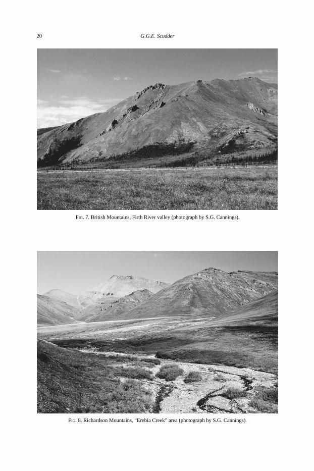
FIG. 7. British Mountains, Firth River valley (photograph by S.G. Cannings).
FIG. 8. Richardson Mountains, “Erebia Creek” area (photograph by S.G. Cannings).
20 G.G.E. Scudder
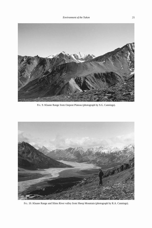
FIG. 9. Kluane Range from Outpost Plateau (photograph by S.G. Cannings).
FIG. 10. Kluane Range and Slims River valley from Sheep Mountain (photograph by R.A. Cannings).
Environment of the Yukon 21
area thickly spotted with lakes and ponds. The southern part of the Porcupine Plain, termedthe Eagle Plain, is an extensive flat, unglaciated area, some 190 km long and 95 km wide,now traversed by the Dempster Highway.
The Tintina Trench runs through the centre of the Yukon Plateau, arising in the PellyMountains in the southeast and then extending straight towards the northwest through RossRiver, and then just south of Mayo and just north of Dawson. Throughout its length it hasareas with well defined walls, varies in width from 4.8 km – 22.5 km, and the floor rangesfrom 425–823 m in elevation.
North of the Tintina Trench, the Yukon Plateau comprises the Stewart Plateau, theMacmillan Plateau and the Pelly Plateau. The Stewart Plateau forms a series of rather flattablelands between the Macmillan River and the southern fronts of the Ogilvie and WerneckeMountains. The steep-sided, steeply cut, broad valleys through the plateau are typical ofunglaciated terrain.
The Macmillan Plateau, which extends from near Ross River to the Macmillan River,forms a broken, mountainous area. Pleistocene ice filled the valleys, but many of themountainous areas between them, particularly in the northwest, stood above the glaciers asnunataks (Bostock 1948). The Pelly Plateau is a glaciated, rolling upland, 1220 –1525 m inelevation, with entrenched valleys that dissect the plateau.
South of the Tintina Trench and the Pelly Mountains the southern part of the YukonPlateau comprises the Lewes Plateau, the Nisultin Plateau and the Teslin Plateau. The LewesPlateau is a broad depression south of the western ranges of the Pelly Mountains. TheNisultin Plateau lies east of Teslin Lake, while the Teslin Plateau lies west of Teslin Lake.
The Shakwak Trench runs diagonally northwest to southeast, parallel with the TintinaTrench, and forms the northern boundary of the Kluane Ranges, and the southern boundaryof the western part of the Yukon Plateau. The northernmost section of this part of the plateauconstitutes the largely unglaciated Klondike Plateau. The latter is a gently undulating areawith a maze of deep, narrow valleys separated, by long, smooth-topped ridges and moun-tains, the most conspicuous forming the Dawson Range.
The more southern section, constituting the Kluane Plateau, is divided into severaldistinct physiographic parts. The southeasternmost portion, east of the Takhini Valley, issome 1675 m in elevation, with peaks 1980 –2134 m high. Northwest of the Takhini Valley,the plateau consists of two topographic basins, the Aishihik Basin and the Wellesley Basin.The Aishihik Basin, at 915 –1220 m, contains Aishihik Lake and has extensive areas ofsmooth rolling plateau and some isolated mountainous areas up to 1830 m. The WellesleyBasin, at 610 m, contains Wellesley Lake, which is surrounded by innumerable kettle-holesoccupied by ponds and small lakes.
Between the Aishihik and Wellesley Basins, the Yukon Plateau forms a wide uplandcomposed of two broad mountainous ridges trending northwest, the Ruby and NislingRanges, separated by a high, shallow trough parallel with the Shakwak Trench (Bostock1948). The Ruby and Nisling Ranges, reaching 2134 m in the former, and 1829 m in thelatter, are composed of granitic intrusions.
Glacial History
During the late Wisconsinan, most of Canada was ice covered. The continental Lauren-tide ice extended from its eastern centre to cover most of north-central and northeasternNorth America (Mickelson et al. 1983). To the northwest it extended no farther than a linerunning roughly along the eastern slopes of the Richardson Mountains and then northwest-
22 G.G.E. Scudder
erly parallel to the Yukon coast to a point near the coast southwest of Herschel Island (Ritchie1984; Hughes et al. 1989).
The Cordilleran ice sheet, which was centred in British Columbia, in the late Wiscon-sinan extended south into northern Washington, Idaho and Montana (Waitt and Thorson1983), and covered virtually all of British Columbia (Clague 1989b), much of southernAlaska (Hamilton and Thorson 1983), and the southern Yukon (Hughes et al. 1989).Mountain glaciers also formed at higher elevations in northern Alaska, especially along theBrooks Range (Heusser 1983; Porter et al. 1983).
At various times during the Pleistocene, the Laurentide and Cordilleran ice sheets werecontiguous, or nearly so, along the western margin of the Great Plains, but during many ofthe glacial advances, growth of the two ice sheets evidently was out of phase (Ryder 1983;Clague 1989c). An ice-free corridor existed between the ice sheets at various times, but thiswas a variable and intermittent entity that existed only in narrow windows of Quaternarytime (Schweger 1989).
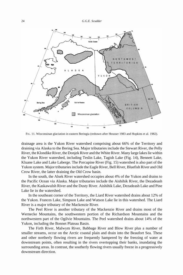
Central Yukon and central Alaska remained unglaciated throughout the Pleistocene(Hopkins 1967; Hopkins et al. 1982), as they lie in a dry belt northeast of the high St. EliasMountains and Alaska Range, where most of the moisture in Pacific air masses is precipitated(Prest 1970). This unglaciated area (Fig. 11) was by far the largest refugium in the northduring the Pleistocene. Together with the emergent Bering and Chukchi seas, at times it alsoformed an unbroken corridor for exchange of Palaearctic and Nearctic flora and fauna(Matthews and Telka 1997). The palaeoecology of this ice-age Beringian refugium issomewhat controversial, and is discussed in detail by Schweger (1997).
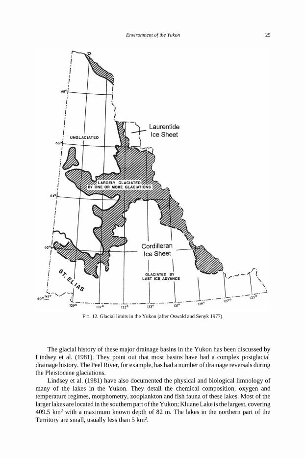
Bostock (1966) inferred four advances of the Cordilleran ice sheet in the southern andcentral Yukon, with each successive advance being less extensive than its predecessor. Fewreadily recognizable landforms remain from the first two advances, and so the limits arepoorly known. However, marginal features of the penultimate (Reid) glaciation terminatingin the Yukon Plateau some 46 600 yr B.P. are moderately well preserved, and those of thefinal late Wisconsinan (McConnell) glaciation, that terminated 13 000 –14 000 yr B.P. arevery well preserved (Hughes et al. 1989). Near the limits of successive glaciations, numerouspeaks and plateaus were isolated as nunataks (Hughes et al. 1983).
Figure 12 depicts the glacial limits of ice advance in the Yukon as summarized byOswald and Senyk (1977). Ice covered the whole of the southern and eastern Yukon, withlobes extending westward to the Tintina Trench, Bonnet Plume Basin, and the Arctic coastalplain. Alpine valley glaciers, contemporary with the continental ice masses, originatedlocally in the Ogilvie, Wernecke, British, and possibly, Richardson Mountains (Hughes1972; Hughes et al. 1969).
The unglaciated portion of the Yukon consists of most of the Klondike, Porcupine andArctic plateaus, the Porcupine Basin and portions of the Ogilvie, Wernecke and BritishMountains, as well as the western slopes of the Richardson Mountains (Oswald and Senyk1977). It is these unglaciated refugial areas that are central to the discussion of Yukonbiogeography, and indeed the present patterns in the fauna and flora of Canada (Scudder1979), and the origins of the whole North American biota (Downes and Kavanaugh 1988).
Drainage Basins
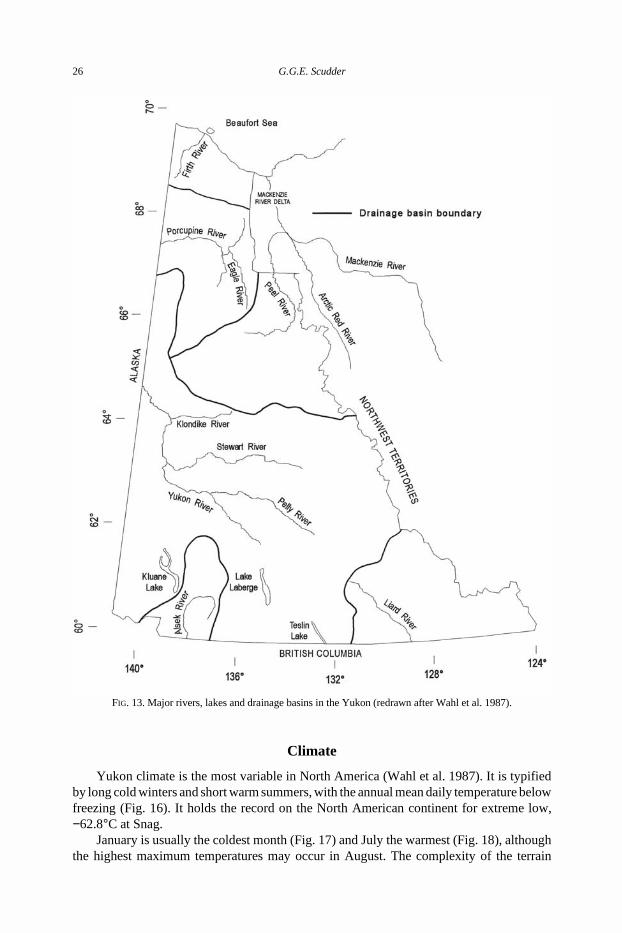
The Yukon is drained by rivers that run to both the Pacific and Arctic Oceans. Thereare five major watersheds, draining to the Beaufort Sea, to the Bering Sea, to the YukonRiver, the Alsek River, and the Mackenzie River (2 subsections) (Fig. 13). The largest
Environment of the Yukon 23
drainage area is the Yukon River watershed comprising about 66% of the Territory anddraining via Alaska to the Bering Sea. Major tributaries include the Stewart River, the PellyRiver, the Klondike River, the Donjek River and the White River. Many large lakes lie withinthe Yukon River watershed, including Teslin Lake, Tagish Lake (Fig. 14), Bennett Lake,Kluane Lake and Lake Laberge. The Porcupine River (Fig. 15) watershed is also part of theYukon system. Major tributaries include the Eagle River, Bell River, Bluefish River and OldCrow River, the latter draining the Old Crow basin.
In the south, the Alsek River watershed occupies about 4% of the Yukon and drains tothe Pacific Ocean via Alaska. Major tributaries include the Aishihik River, the DezadeashRiver, the Kaskawulsh River and the Dusty River. Aishihik Lake, Dezadeash Lake and PineLake lie in the watershed.
In the southeast corner of the Territory, the Liard River watershed drains about 12% ofthe Yukon. Frances Lake, Simpson Lake and Watson Lake lie in this watershed. The LiardRiver is a major tributary of the Mackenzie River.
The Peel River is another tributary of the Mackenzie River and drains most of theWernecke Mountains, the southwestern portion of the Richardson Mountains and thenorthwestern part of the Ogilvie Mountains. The Peel watershed drains about 14% of theYukon, including the Bonnet Plateau Basin.
The Firth River, Malwym River, Babbage River and Blow River plus a number ofsmaller streams, occur on the Arctic coastal plain and drain into the Beaufort Sea. Theseand other northerly flowing rivers are frequently hampered by the freezing of water atdownstream points, often resulting in the rivers overtopping their banks, inundating thesurrounding areas. In contrast, the southerly flowing rivers usually freeze in a progressivelydownstream direction.
FIG. 11. Wisconsinan glaciation in eastern Beringia (redrawn after Heusser 1983 and Hopkins et al. 1982).
24 G.G.E. Scudder
The glacial history of these major drainage basins in the Yukon has been discussed byLindsey et al. (1981). They point out that most basins have had a complex postglacialdrainage history. The Peel River, for example, has had a number of drainage reversals duringthe Pleistocene glaciations.
Lindsey et al. (1981) have also documented the physical and biological limnology ofmany of the lakes in the Yukon. They detail the chemical composition, oxygen andtemperature regimes, morphometry, zooplankton and fish fauna of these lakes. Most of thelarger lakes are located in the southern part of the Yukon; Kluane Lake is the largest, covering409.5 km2 with a maximum known depth of 82 m. The lakes in the northern part of theTerritory are small, usually less than 5 km2.
FIG. 12. Glacial limits in the Yukon (after Oswald and Senyk 1977).
Environment of the Yukon 25
Climate
Yukon climate is the most variable in North America (Wahl et al. 1987). It is typifiedby long cold winters and short warm summers, with the annual mean daily temperature belowfreezing (Fig. 16). It holds the record on the North American continent for extreme low,−62.8°C at Snag.
January is usually the coldest month (Fig. 17) and July the warmest (Fig. 18), althoughthe highest maximum temperatures may occur in August. The complexity of the terrain
FIG. 13. Major rivers, lakes and drainage basins in the Yukon (redrawn after Wahl et al. 1987).
26 G.G.E. Scudder
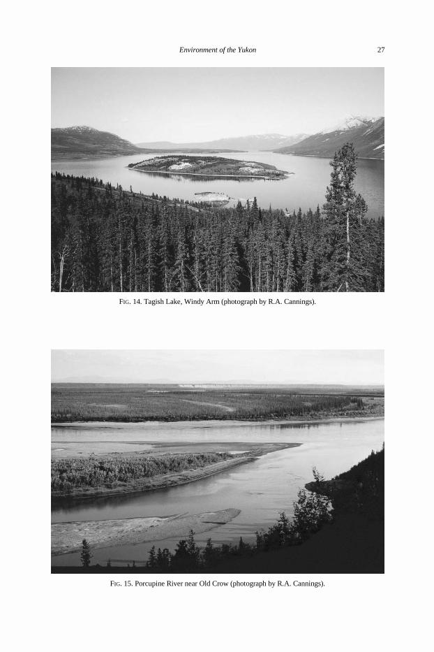
FIG. 14. Tagish Lake, Windy Arm (photograph by R.A. Cannings).
FIG. 15. Porcupine River near Old Crow (photograph by R.A. Cannings).
Environment of the Yukon 27
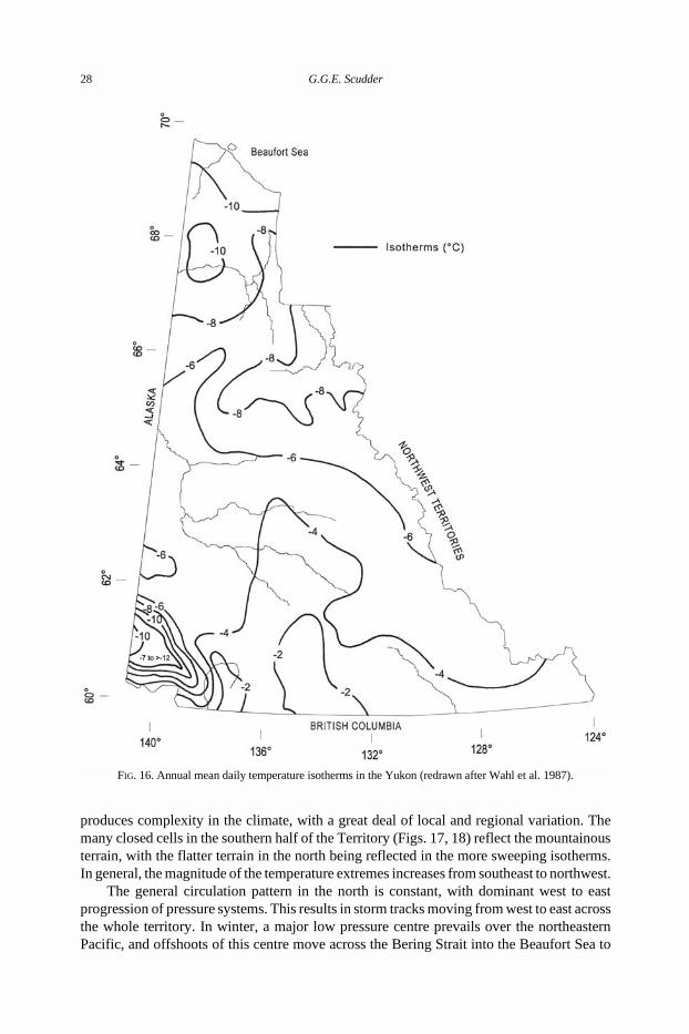
produces complexity in the climate, with a great deal of local and regional variation. Themany closed cells in the southern half of the Territory (Figs. 17, 18) reflect the mountainousterrain, with the flatter terrain in the north being reflected in the more sweeping isotherms.In general, the magnitude of the temperature extremes increases from southeast to northwest.
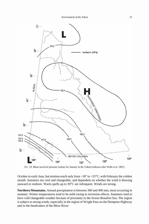
The general circulation pattern in the north is constant, with dominant west to eastprogression of pressure systems. This results in storm tracks moving from west to east acrossthe whole territory. In winter, a major low pressure centre prevails over the northeasternPacific, and offshoots of this centre move across the Bering Strait into the Beaufort Sea to
FIG. 16. Annual mean daily temperature isotherms in the Yukon (redrawn after Wahl et al. 1987).
28 G.G.E. Scudder
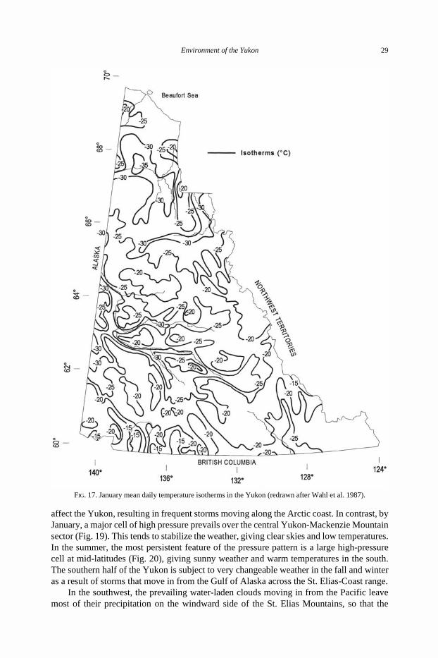
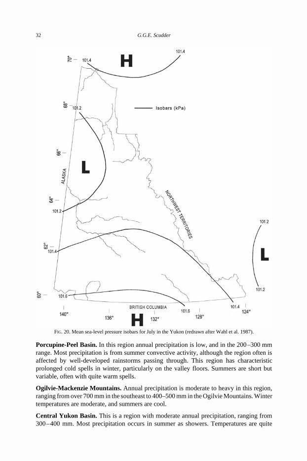
affect the Yukon, resulting in frequent storms moving along the Arctic coast. In contrast, byJanuary, a major cell of high pressure prevails over the central Yukon-Mackenzie Mountainsector (Fig. 19). This tends to stabilize the weather, giving clear skies and low temperatures.In the summer, the most persistent feature of the pressure pattern is a large high-pressurecell at mid-latitudes (Fig. 20), giving sunny weather and warm temperatures in the south.The southern half of the Yukon is subject to very changeable weather in the fall and winteras a result of storms that move in from the Gulf of Alaska across the St. Elias-Coast range.
In the southwest, the prevailing water-laden clouds moving in from the Pacific leavemost of their precipitation on the windward side of the St. Elias Mountains, so that the
FIG. 17. January mean daily temperature isotherms in the Yukon (redrawn after Wahl et al. 1987).
Environment of the Yukon 29
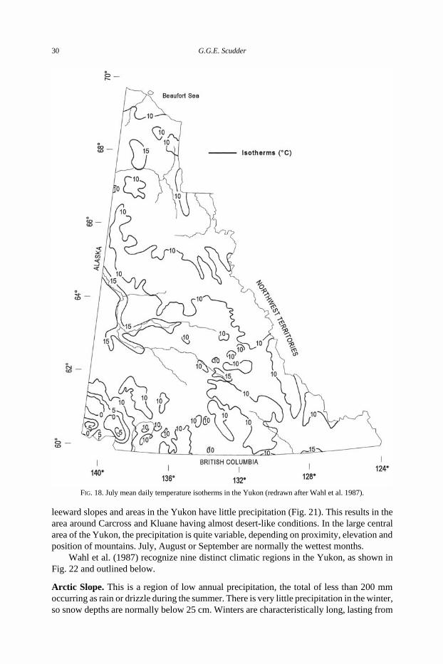
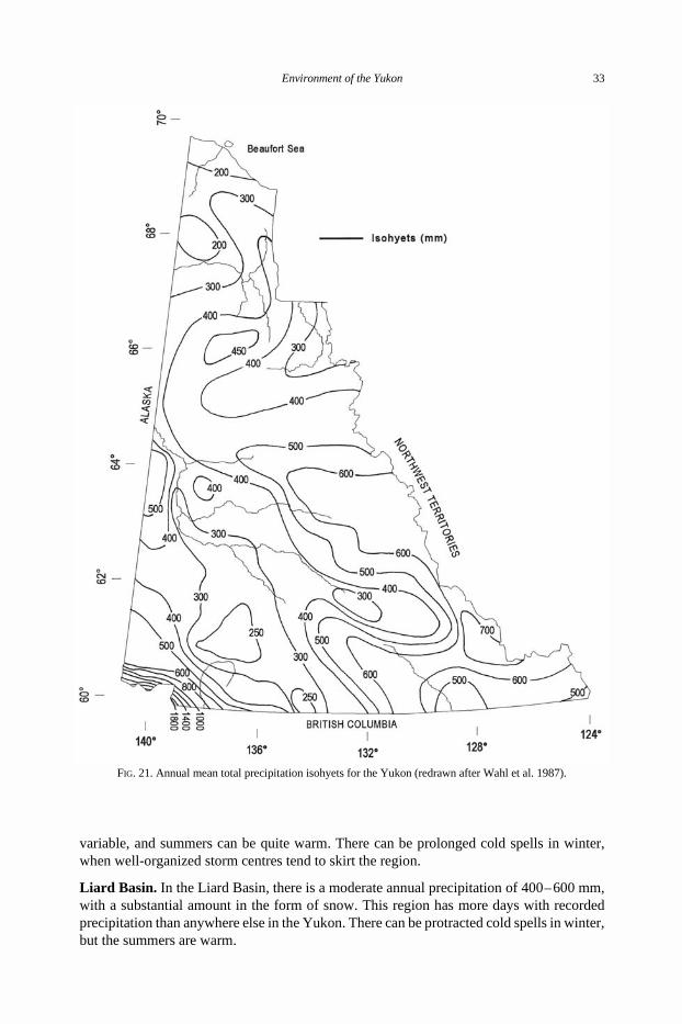
leeward slopes and areas in the Yukon have little precipitation (Fig. 21). This results in thearea around Carcross and Kluane having almost desert-like conditions. In the large centralarea of the Yukon, the precipitation is quite variable, depending on proximity, elevation andposition of mountains. July, August or September are normally the wettest months.
Wahl et al. (1987) recognize nine distinct climatic regions in the Yukon, as shown inFig. 22 and outlined below.
Arctic Slope. This is a region of low annual precipitation, the total of less than 200 mmoccurring as rain or drizzle during the summer. There is very little precipitation in the winter,so snow depths are normally below 25 cm. Winters are characteristically long, lasting from
FIG. 18. July mean daily temperature isotherms in the Yukon (redrawn after Wahl et al. 1987).
30 G.G.E. Scudder
October to early June, but minima reach only from −50° to −55°C, with February the coldestmonth. Summers are cool and changeable, and dependent on whether the wind is blowingseaward or onshore. Warm spells up to 30°C are infrequent. Winds are strong.
Northern Mountains. Annual precipitation is between 300 and 400 mm, most occurring insummer. Winter temperatures tend to be mild owing to inversion effects. Summers tend tohave cold changeable weather because of proximity to the frozen Beaufort Sea. The regionis subject to strong winds, especially in the region of Wright Pass on the Dempster Highwayand in the headwaters of the Blow River.
FIG. 19. Mean sea-level pressure isobars for January in the Yukon (redrawn after Wahl et al. 1987).
Environment of the Yukon 31
Porcupine-Peel Basin. In this region annual precipitation is low, and in the 200 –300 mmrange. Most precipitation is from summer convective activity, although the region often isaffected by well-developed rainstorms passing through. This region has characteristicprolonged cold spells in winter, particularly on the valley floors. Summers are short butvariable, often with quite warm spells.
Ogilvie-Mackenzie Mountains. Annual precipitation is moderate to heavy in this region,ranging from over 700 mm in the southeast to 400–500 mm in the Ogilvie Mountains. Wintertemperatures are moderate, and summers are cool.
Central Yukon Basin. This is a region with moderate annual precipitation, ranging from300 – 400 mm. Most precipitation occurs in summer as showers. Temperatures are quite
FIG. 20. Mean sea-level pressure isobars for July in the Yukon (redrawn after Wahl et al. 1987).
32 G.G.E. Scudder
variable, and summers can be quite warm. There can be prolonged cold spells in winter,when well-organized storm centres tend to skirt the region.
Liard Basin. In the Liard Basin, there is a moderate annual precipitation of 400 – 600 mm,with a substantial amount in the form of snow. This region has more days with recordedprecipitation than anywhere else in the Yukon. There can be protracted cold spells in winter,but the summers are warm.
FIG. 21. Annual mean total precipitation isohyets for the Yukon (redrawn after Wahl et al. 1987).
Environment of the Yukon 33
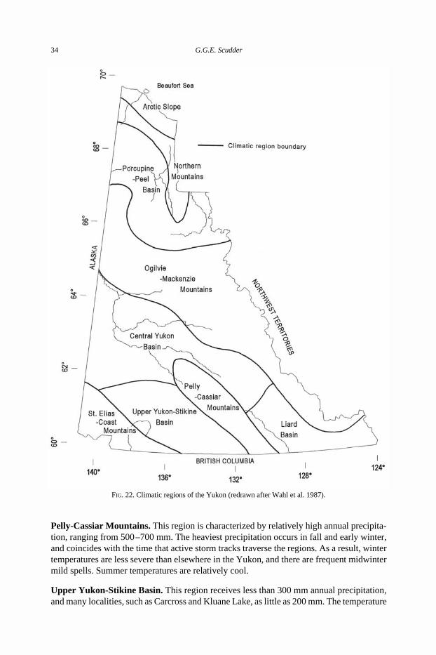
Pelly-Cassiar Mountains. This region is characterized by relatively high annual precipita-tion, ranging from 500 –700 mm. The heaviest precipitation occurs in fall and early winter,and coincides with the time that active storm tracks traverse the regions. As a result, wintertemperatures are less severe than elsewhere in the Yukon, and there are frequent midwintermild spells. Summer temperatures are relatively cool.
Upper Yukon-Stikine Basin. This region receives less than 300 mm annual precipitation,and many localities, such as Carcross and Kluane Lake, as little as 200 mm. The temperature
FIG. 22. Climatic regions of the Yukon (redrawn after Wahl et al. 1987).
34 G.G.E. Scudder
regime is typically continental, with a great deal of variability on both a daily and seasonalbasis. The proximity to the Pacific Ocean results in more frequent midwinter mild spellsthan occur elsewhere in the Yukon.
St. Elias-Coast Mountains. The climate in this region is transitional between the wetmaritime climate of the windward coastal area and the dry continental climate northeast ofthe massive mountains. Annual total precipitation is up to 4000 mm on the coast, butdecreases to under 300 mm in the Shakwak Trench. Precipitation is mostly in the form ofsnow above 3000 m, and major snow accumulation occurs between 1500 and 3000 m. Thisresults in the extensive network of glaciers in the Icefield Ranges, within the St. EliasMountains. Valley glaciers extend downslope from accumulation zones to the 900 –1200 mlevel. At low elevations, liquid precipitation occurs from mid-May to September.
Temperatures in the region vary widely as a result of the complex topography and stormpaths from the Gulf of Alaska. The mean annual temperature within the St. Elias Mountainsabove 2500 m is −10°C to −15°C. The region is one of the windiest in the Yukon.
Permafrost
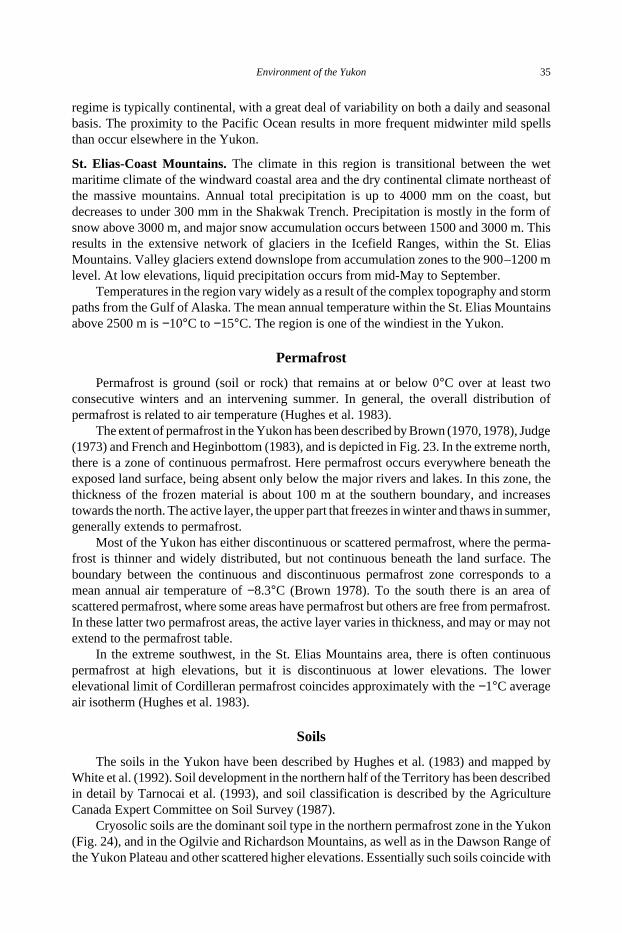
Permafrost is ground (soil or rock) that remains at or below 0°C over at least twoconsecutive winters and an intervening summer. In general, the overall distribution ofpermafrost is related to air temperature (Hughes et al. 1983).
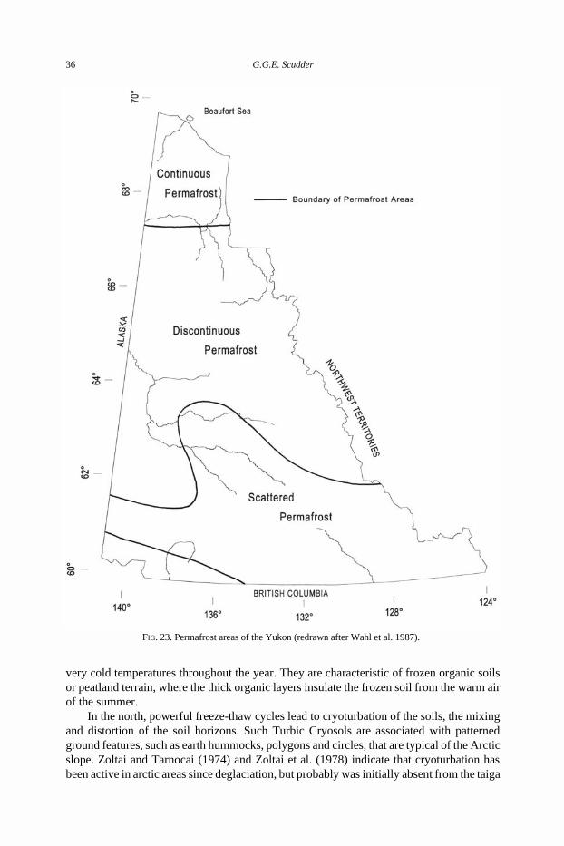
The extent of permafrost in the Yukon has been described by Brown (1970, 1978), Judge(1973) and French and Heginbottom (1983), and is depicted in Fig. 23. In the extreme north,there is a zone of continuous permafrost. Here permafrost occurs everywhere beneath theexposed land surface, being absent only below the major rivers and lakes. In this zone, thethickness of the frozen material is about 100 m at the southern boundary, and increasestowards the north. The active layer, the upper part that freezes in winter and thaws in summer,generally extends to permafrost.
Most of the Yukon has either discontinuous or scattered permafrost, where the perma-frost is thinner and widely distributed, but not continuous beneath the land surface. Theboundary between the continuous and discontinuous permafrost zone corresponds to amean annual air temperature of −8.3°C (Brown 1978). To the south there is an area ofscattered permafrost, where some areas have permafrost but others are free from permafrost.In these latter two permafrost areas, the active layer varies in thickness, and may or may notextend to the permafrost table.
In the extreme southwest, in the St. Elias Mountains area, there is often continuouspermafrost at high elevations, but it is discontinuous at lower elevations. The lowerelevational limit of Cordilleran permafrost coincides approximately with the −1°C averageair isotherm (Hughes et al. 1983).
Soils
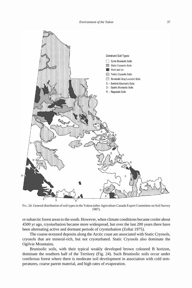
The soils in the Yukon have been described by Hughes et al. (1983) and mapped byWhite et al. (1992). Soil development in the northern half of the Territory has been describedin detail by Tarnocai et al. (1993), and soil classification is described by the AgricultureCanada Expert Committee on Soil Survey (1987).
Cryosolic soils are the dominant soil type in the northern permafrost zone in the Yukon(Fig. 24), and in the Ogilvie and Richardson Mountains, as well as in the Dawson Range ofthe Yukon Plateau and other scattered higher elevations. Essentially such soils coincide with
Environment of the Yukon 35
very cold temperatures throughout the year. They are characteristic of frozen organic soilsor peatland terrain, where the thick organic layers insulate the frozen soil from the warm airof the summer.
In the north, powerful freeze-thaw cycles lead to cryoturbation of the soils, the mixingand distortion of the soil horizons. Such Turbic Cryosols are associated with patternedground features, such as earth hummocks, polygons and circles, that are typical of the Arcticslope. Zoltai and Tarnocai (1974) and Zoltai et al. (1978) indicate that cryoturbation hasbeen active in arctic areas since deglaciation, but probably was initially absent from the taiga
FIG. 23. Permafrost areas of the Yukon (redrawn after Wahl et al. 1987).
36 G.G.E. Scudder
or subarctic forest areas to the south. However, when climate conditions became cooler about4500 yr ago, cryoturbation became more widespread, but over the last 200 years there havebeen alternating active and dormant periods of cryoturbation (Zoltai 1975).
The coarse-textured deposits along the Arctic coast are associated with Static Cryosols,cryosols that are mineral-rich, but not cryoturbated. Static Cryosols also dominate theOgilvie Mountains.
Brunisolic soils, with their typical weakly developed brown coloured B horizon,dominate the southern half of the Territory (Fig. 24). Such Brunisolic soils occur underconiferous forest where there is moderate soil development in association with cold tem-peratures, coarse parent material, and high rates of evaporation.
FIG. 24. General distribution of soil types in the Yukon (after Agriculture Canada Expert Committee on Soil Survey1987).
Environment of the Yukon 37
Most of the southern half of the Yukon has Eutric Brunisols, which are not strongly acidand have a well developed Ah horizon. However, in the southern Selwyn Mountains and theLogan Mountains, and other scattered areas such as the Coast Mountains and the CassiarMountains, Dystric Brunisols are found, brunisols which are strongly acid but lack awell-developed Ah horizon. Brunisolic gray luvisolic soils, with clay accumulation in theB horizon, are confined to the southeast corner of the Territory in the Liard River basin.These luvisolic soils develop in cool to cold soil climates, and typically occur on fine-tex-tured glacio-lacustrine deposits.
Chernozemic soils, with well-developed, base-rich, mineral-organic surface horizons(Ah), are grassland soils, and are not common in the Yukon. They occur on the warm, steepsouth-facing slopes in the south and central Yukon, particularly along the Yukon Riversystem. Regosolic soils, with very weak horizon development, are also scarce, and are largelyconfined to the valley bottoms of the Peel and Yukon River system.
There are extensive areas of the Yukon that lack soil development. Such rock outcropareas occur mainly in the Richardson, Ogilvie, Selwyn, Logan and St. Elias Mountains.
Vegetation
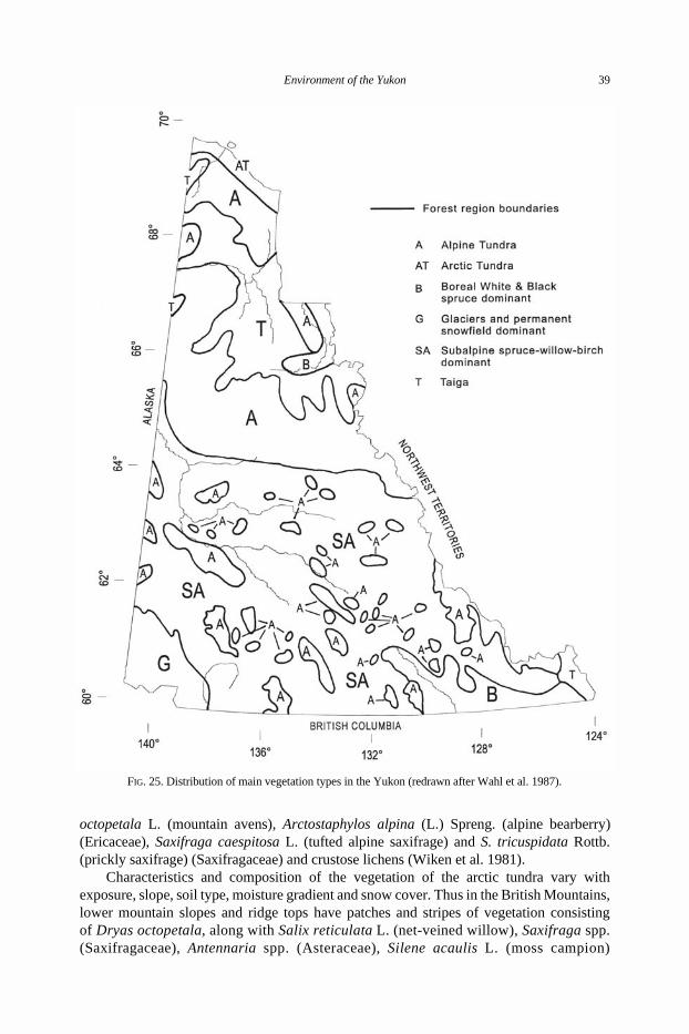
The vegetation of the Yukon, like the rest of northern Canada, strongly reflectslatitudinal and elevational temperature gradients (Hughes et al. 1983). The dominantvegetation types in the Yukon are arctic tundra, alpine tundra, taiga or subarctic forest, borealforest and subalpine-shrub forest (Fig. 25).
Arctic Tundra. Arctic tundra, which occurs as the dominant vegetation type in the low arcticYukon Coastal Plain, is treeless, with a continuous vegetative cover (Fig. 26). Typical arctictundra plants include Eriophorum vaginatum L. (sheathed cottongrass) and Carex aquatilisWahlenb. (aquatic sedge) (Cyperaceae), Salix arctica Pall. (arctic willow) (Salicaceae),Cassiope tetragona (L.) D. Don (white arctic bell-heather) (Ericaceae), Rumex arcticusTrautv. (arctic dock) (Polygonaceae), and Dryas integrifolia M. Vahl. (arctic avens)(Rosaceae) (Wiken et al. 1981).
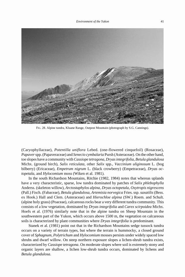
In upland areas, the vegetation consists primarily of tussocks of cottongrass (Eriopho-rum spp.), interspersed with trailing shrubs and heaths. In low-lying depressions, sedgesand mosses are dominant. Thus, in upland areas, such as the area between Fish Creek andClarence Lagoon, the elevated and well drained central portion of Herschel Island (Fig. 27),and the higher morainal areas east of Herschel Island, the vegetation consists of expansesof tussock tundra dominated by Eriophorum vaginatum, Ledum decumbens (Ait) Lodd.(narrow-leaved Labrador tea) and Vaccinium vitis-idaea L. ssp. minus (Ludd.) Hult. (moun-tain cranberry) (Ericaceae), Betula nana L. ssp. exilis (Sukatsch.) Hult. (dwarf birch)(Betulaceae) and mosses (Wiken et al. 1981).
Lowland areas, which are dominated by low-centre frost polygons, have cores coveredby sedges and Sphagnum spp., along with Ledum decumbens, Andromeda polifolia L. (bogrosemary) (Ericaceae), Vaccinium vitis-idaea, Salix spp., and Betula nana forming elevatedrims. High-centre polygons have tussocks of Eriophorum vaginatum in the elevated centralportions, and mostly Carex aquatilis in the ice-wedge troughs (Wiken et al. 1981).
Alpine Tundra. Alpine tundra (Fig. 28) occurs throughout the British-Richardson Moun-tains, the Ogilvie, Wernecke and Selwyn Mountains, the St. Elias Mountains, and scatteredat higher elevations in the interior Cordilleran region of the Yukon, especially in the PellyMountains and Dawson Ranges (Fig. 4). Typical alpine tundra plants include Dryas
38 G.G.E. Scudder
octopetala L. (mountain avens), Arctostaphylos alpina (L.) Spreng. (alpine bearberry)(Ericaceae), Saxifraga caespitosa L. (tufted alpine saxifrage) and S. tricuspidata Rottb.(prickly saxifrage) (Saxifragaceae) and crustose lichens (Wiken et al. 1981).
Characteristics and composition of the vegetation of the arctic tundra vary withexposure, slope, soil type, moisture gradient and snow cover. Thus in the British Mountains,lower mountain slopes and ridge tops have patches and stripes of vegetation consistingof Dryas octopetala, along with Salix reticulata L. (net-veined willow), Saxifraga spp.(Saxifragaceae), Antennaria spp. (Asteraceae), Silene acaulis L. (moss campion)
FIG. 25. Distribution of main vegetation types in the Yukon (redrawn after Wahl et al. 1987).
Environment of the Yukon 39
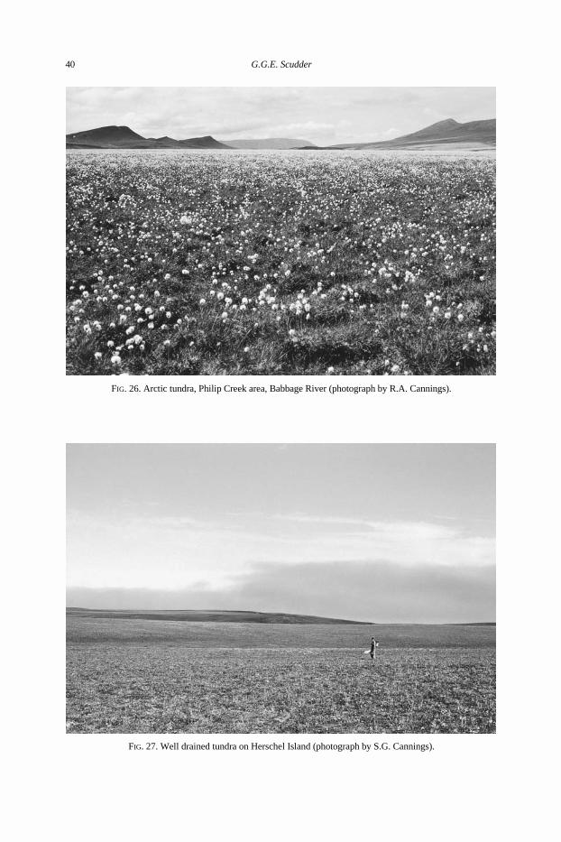
FIG. 26. Arctic tundra, Philip Creek area, Babbage River (photograph by R.A. Cannings).
FIG. 27. Well drained tundra on Herschel Island (photograph by S.G. Cannings).
40 G.G.E. Scudder
(Caryophyllaceae), Potentilla uniflora Lebed. (one-flowered cinquefoil) (Rosaceae),Papaver spp. (Papaveraceae) and Senecio cymbalaria Pursh (Asteraceae). On the other hand,toe slopes have a community with Cassiope tetragona, Dryas integrifolia, Betula glandulosaMichx. (ground birch), Salix reticulata, other Salix spp., Vaccinium uliginosum L. (bogbilberry) (Ericaceae), Empetrum nigrum L. (black crowberry) (Empetraceae), Dryas oc-topetala, and Hylocomium moss (Wiken et al. 1981).
In the south Richardson Mountains, Ritchie (1982, 1984) notes that whereas uplandshave a very characteristic, sparse, low tundra dominated by patches of Salix phlebophyllaAnderss. (skeleton willow), Arctostaphylos alpina, Dryas octopetala, Oxytropis nigrescens(Pall.) Fisch. (Fabaceae), Betula glandulosa, Artemisia norvegica Fries. ssp. saxatilis (Bess.ex Hook.) Hall and Clem. (Asteraceae) and Hierochloe alpina (SW.) Roem. and Schult.(alpine holy grass) (Poaceae), calcareous rocks bear a very different tundra community. Thisconsists of a low vegetation, dominated by Dryas integrifolia and Carex scirpoidea Michx.Hoefs et al. (1976) similarly note that in the alpine tundra on Sheep Mountain in thesouthwestern part of the Yukon, which occurs above 1500 m, the vegetation on calcareoussoils is characterized by plant communities where Dryas integrifolia is predominant.
Stanek et al. (1981) point out that in the Richardson Mountains sedge tussock tundraoccurs on a variety of terrain types, but where the terrain is hummocky, a closed groundcover of Sphagnum, Polytrichum and Hylocomium mosses persists under widely spaced lowshrubs and dwarf willow. On steep northern exposure slopes a lichen-shrub tundra exists,characterized by Cassiope tetragona. On moderate slopes where soil is extremely stony andorganic layers are shallow, a lichen low-shrub tundra occurs, dominated by lichens andBetula glandulosa.
FIG. 28. Alpine tundra, Kluane Range, Outpost Mountain (photograph by S.G. Cannings).
Environment of the Yukon 41
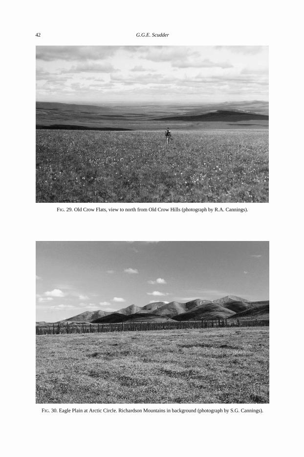
FIG. 29. Old Crow Flats, view to north from Old Crow Hills (photograph by R.A. Cannings).
FIG. 30. Eagle Plain at Arctic Circle. Richardson Mountains in background (photograph by S.G. Cannings).
42 G.G.E. Scudder
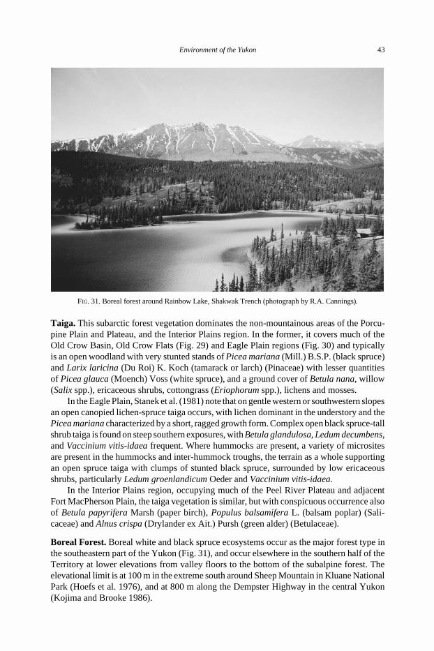
Taiga. This subarctic forest vegetation dominates the non-mountainous areas of the Porcu-pine Plain and Plateau, and the Interior Plains region. In the former, it covers much of theOld Crow Basin, Old Crow Flats (Fig. 29) and Eagle Plain regions (Fig. 30) and typicallyis an open woodland with very stunted stands of Picea mariana (Mill.) B.S.P. (black spruce)and Larix laricina (Du Roi) K. Koch (tamarack or larch) (Pinaceae) with lesser quantitiesof Picea glauca (Moench) Voss (white spruce), and a ground cover of Betula nana, willow(Salix spp.), ericaceous shrubs, cottongrass (Eriophorum spp.), lichens and mosses.
In the Eagle Plain, Stanek et al. (1981) note that on gentle western or southwestern slopesan open canopied lichen-spruce taiga occurs, with lichen dominant in the understory and thePicea mariana characterized by a short, ragged growth form. Complex open black spruce-tallshrub taiga is found on steep southern exposures, with Betula glandulosa, Ledum decumbens,and Vaccinium vitis-idaea frequent. Where hummocks are present, a variety of micrositesare present in the hummocks and inter-hummock troughs, the terrain as a whole supportingan open spruce taiga with clumps of stunted black spruce, surrounded by low ericaceousshrubs, particularly Ledum groenlandicum Oeder and Vaccinium vitis-idaea.
In the Interior Plains region, occupying much of the Peel River Plateau and adjacentFort MacPherson Plain, the taiga vegetation is similar, but with conspicuous occurrence alsoof Betula papyrifera Marsh (paper birch), Populus balsamifera L. (balsam poplar) (Sali-caceae) and Alnus crispa (Drylander ex Ait.) Pursh (green alder) (Betulaceae).
Boreal Forest. Boreal white and black spruce ecosystems occur as the major forest type inthe southeastern part of the Yukon (Fig. 31), and occur elsewhere in the southern half of theTerritory at lower elevations from valley floors to the bottom of the subalpine forest. Theelevational limit is at 100 m in the extreme south around Sheep Mountain in Kluane NationalPark (Hoefs et al. 1976), and at 800 m along the Dempster Highway in the central Yukon(Kojima and Brooke 1986).
FIG. 31. Boreal forest around Rainbow Lake, Shakwak Trench (photograph by R.A. Cannings).
Environment of the Yukon 43
This forest is dominated by Picea glauca in most late seral and climatic climax stands.It is usually accompanied by a number of other trees that have a broad boreal distributionacross Canada, and have moved into the Yukon from the east in postglacial time (Delcourtand Delcourt 1987). These include Picea mariana, Populus tremuloides Michx. (tremblingaspen), P. balsamifera, Larix laricina and Betula papyrifera (these important plants areillustrated in Stanek and Orloci 1987). However, in the Yukon, two other conifers of westernorigin are major components of the white and black spruce boreal forests, namely Pinuscontorta Dougl. (lodgepole pine) and Abies lasiocarpa (Hook.) Nutt. (alpine fir) (Pinaceae).
Species composition and vegetation characteristics vary according to climate, aspect,soil type and drainage, with dense black spruce-moss communities developing in imperfectlydrained sites (Meideniger and Pojar 1991). Stanek (1980) has described the vegetation typesin the Liard Basin, noting that here Picea glauca is dominant in primary and old secondarystands. Populus tremuloides forms secondary stands on finer soils in warm sites, while Piceamariana and Larix laricina are characteristic in some wetlands, but Salix shrub communitiesoccur in others. Betula papyrifera occurs sporadically.
Bonnor and Oswald (1989) in their reconnaissance inventory of Yukon forest resourcespoint out that nearly all of the land below the alpine zone in the southern Yukon has beenburnt in the last 300 years, much of it several times; because Picea glauca takes at least 25years to produce viable seed, lacks serotinous cones, and does not reproduce by layering,this tree is sparse or virtually absent in many areas. Indeed, some tracts of land in the southernYukon currently support only shrubs owing to the elimination of tree species and theirpropagules as a result of repeated fires at short intervals (Oswald and Brown 1990).
Pinus contorta and Populus tremuloides owe their existence for the most part to theoccurrence of fire, because they are initial invaders in recolonization. Pinus contortapossesses serotinous cones which release lots of seeds when opened by fire and can startreproducing in less than 10 years; it thrives best on relatively coarse, textured, moderatelywell to excessively drained soils that can have a moisture deficit during the summer (Bonnorand Oswald 1989). Populus tremuloides, on the other hand, reproduces after fire largely bysuckering, especially on finer textured, moist or somewhat alkaline sites.
Oswald and Brown (1986), in their study of the forest around Lake Laberge, describeover 50 distinct plant communities involving Picea glauca, P. mariana, Pinus contorta andPopulus tremuloides. Douglas (1974) described the plant communities in the boreal whiteand black spruce forest ecosystem in the Alsek River region in the southwest Yukon, notingthat here is a mosaic of forest, shrub and herb communities. This mosaic results fromthe variable climate within the region and frequent disturbance by both fire and geomor-phological (mainly fluvial) processes. These factors create twenty-one distinct communitytypes, which is extremely diverse for a boreal forest area.
Subalpine Forest-shrub. The subalpine zone, with a characteristic spruce-willow-birchecosystem (Meidinger and Pojar 1991), occurs between the boreal white and black spruceforest and the alpine tundra zone. Krajina (1975) recognized two elevational subzones, alower forested subzone and an upper shrub subzone. In the former, tree cover is like that inthe boreal white and black spruce zone, but the occurrence of Betula glandulosa in forestedas well as the non-forested upper subzone indicates the subalpine habitat.
Kojima and Brooke (1986) report that the shrub subzone on the Dempster Highwayis characterized by the shrub thickets of Betula glandulosa and Salix spp. (mostly S. plani-folia Pursh ssp. pulchra (Cham.) Argus). B. glandulosa is common on moderately towell-drained habitats near and above treeline, but is gradually replaced by Salix spp.,
44 G.G.E. Scudder
especially S. planifolia ssp. pulchra and S. glauca L., in more moist habitats near the baseof slopes or valley bottoms, where willow may completely dominate the vegetation. In placesin the subalpine zone Picea mariana occurs as Krummholtz.
Stanek et al. (1981) describe this subalpine shrub vegetation type on the gently slopingterrain of the Eagle Plain as a dwarf shrub tundra, noting that characteristic species in additionto B. glandulosa and S. planifolia ssp. pulchra, and irregularly scattered P. mariana, includeArctostaphylos alpina, A. rubra (Rehd. and Wilson) Fern., Empetrum nigrum L. (Empe-traceae), Ledum decumbens, Rubus chamaemorus L. (Rosaceae), Petasites frigidus (L.)Fries. (Asteraceae), Vaccinium uliginosum and V. vitis-idaea, sedges such as Carex spp. andEriophorum vaginatum, the grasses Arctagrostis latifolia (R. Br.) Griseb. and Calamagrostiscanadensis (Michx.) Beauv. (Poaceae) and lichens.
In the Alsek River region, the subalpine zone, which occurs up to 1080 –1370 m, isdominated essentially by tall (up to 3 – 4 m) shrubs, mainly Salix spp. with scattered Piceaglauca (Douglas 1974). In the Sheep Mountain area of Kluane National Park, the subalpinezone occurs between 1100 and 1500 m (Hoefs et al. 1976), with two distinct plantassociations. One occurs on mesic sites and is dominated by Betula glandulosa, Salix glauca,S. reticulata and Arctostaphylos rubra. The other occurs on sites which are more hygric,with longer snow duration, and is dominated by B. glandulosa, S. glauca, S. lanata L.,S. reticulata, Arctostaphylos rubra, Cassiope tetragona and Vaccinium uliginosum.
Notable Habitats
A number of notable habitats in the Yukon are likely to have special and distinctiveinsect faunas. These habitats include springs, peatlands, saline flats, sand dunes and xericArtemisia frigida-grass communities.
Springs. There are a number of major springs in the Yukon (Souther and Halstead 1969).The hotsprings at Takhini and the sulphur springs at Engineer Creek on the DempsterHighway are just two examples. Unfortunately, there appears to be no detailed and compre-hensive study of the characteristics and biota of the Yukon springs. However, one mightexpect Diptera, Coleoptera, and Trichoptera to occur in such habitats, as these are typicalspring inhabitants (Danks and Williams 1991).
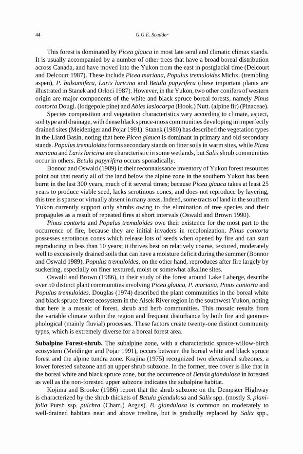
Peatlands. There are extensive peatlands in the Yukon (Natural Wetlands Working Group1988; Tarnocai et al. 1995) (Fig. 32). In the Yukon coastal plain, permafrost underlies allthe low arctic wetlands at shallow depths, and the wetlands are induced by the developmentof ice wedges in the ground. These result in either low-centre polygons with soil- andpeat-formed dams around shallow pools (Fig. 33), or high-centre polygons that result frompeat accumulation (Zoltai 1987).
In the subarctic alpine tundra and taiga areas, the predominant form of the peatland isa peat plateau, wherein a perennially frozen peatland is elevated by permafrost above theregional water table (Zoltai 1987). Zoltai (1987) notes that such peat plateaus are dry on thesurface, except for small damp depressions, and generally have vegetation that resemblesthat of the surrounding uplands. However, the surrounding fens are rich in nutrients, andsupport mainly sedge and moss vegetation communities. In the boreal forest, the peatlandsare mostly in the form of fens, with bogs uncommon (Zoltai 1987). Fens are waterloggedpeatlands, with water generally rich in mineral nutrients, and with pH 5.5 – 7.5. Bogs incontrast are peat-covered wetlands, generally lacking nutrients and with acidic waters,usually with pH , 4.5 (Zoltai 1987).
Environment of the Yukon 45
Although data on occurrence of insects in fens is very scanty, a number of Odonata andColeoptera, in particular, are restricted to bogs (Danks and Rosenberg 1987). Becausepeatlands are extensive in the Yukon, it is expected that peatland-adapted species in at leastthese two groups of insects will be common in the Territory.
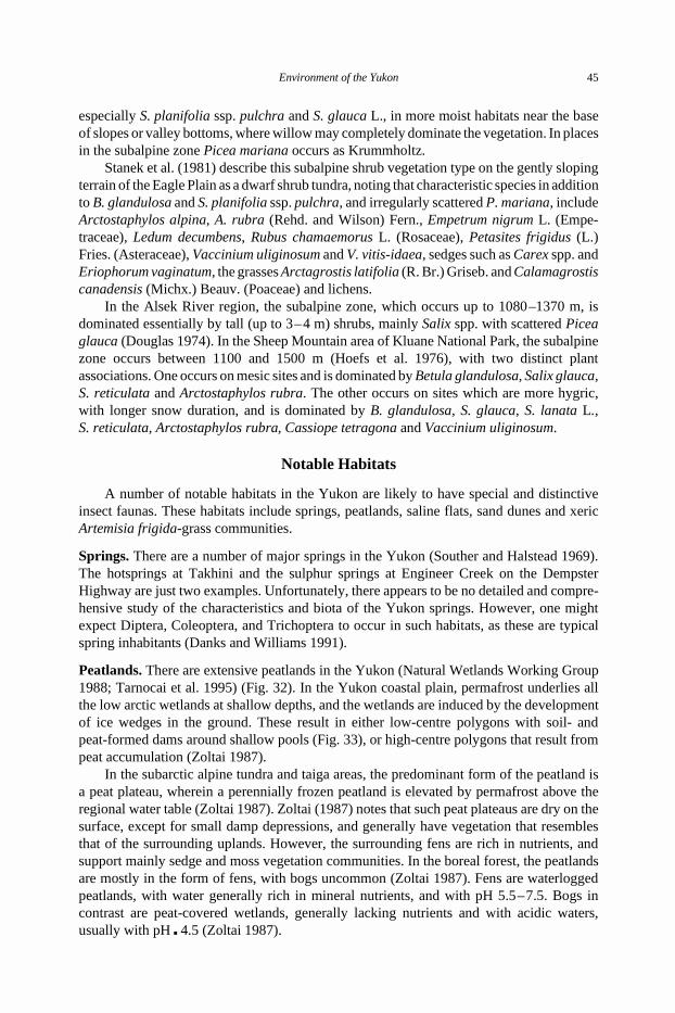
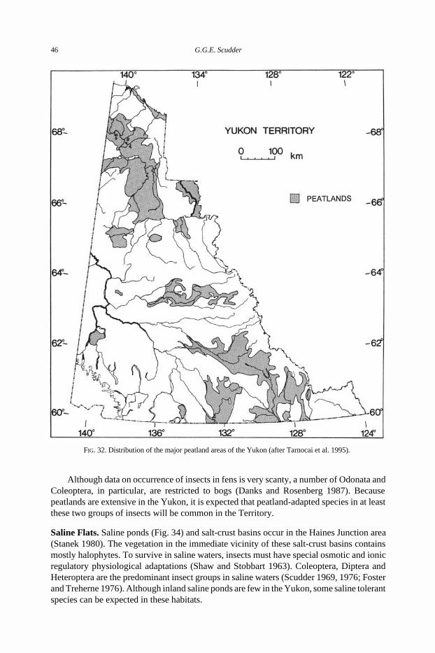
Saline Flats. Saline ponds (Fig. 34) and salt-crust basins occur in the Haines Junction area(Stanek 1980). The vegetation in the immediate vicinity of these salt-crust basins containsmostly halophytes. To survive in saline waters, insects must have special osmotic and ionicregulatory physiological adaptations (Shaw and Stobbart 1963). Coleoptera, Diptera andHeteroptera are the predominant insect groups in saline waters (Scudder 1969, 1976; Fosterand Treherne 1976). Although inland saline ponds are few in the Yukon, some saline tolerantspecies can be expected in these habitats.
FIG. 32. Distribution of the major peatland areas of the Yukon (after Tarnocai et al. 1995).
46 G.G.E. Scudder
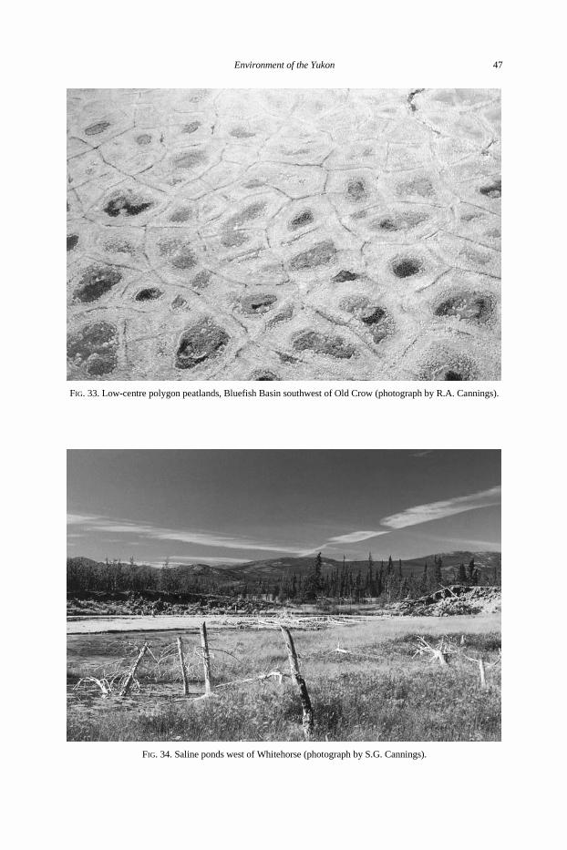
FIG. 33. Low-centre polygon peatlands, Bluefish Basin southwest of Old Crow (photograph by R.A. Cannings).
FIG. 34. Saline ponds west of Whitehorse (photograph by S.G. Cannings).
Environment of the Yukon 47
Sand Dunes. The main sand-dune areas in the Yukon occur in the south near Carcross andin the Alsek River region. Douglas (1974) describes two distinct herb communities in thedunes near the junction of the Alsek and Dezadeash Rivers. One occurs on the stabilizedsand dunes and is characterized by a continuous but sparse cover of Carex sabulosa Turcz.ssp. leiophylla (Mack.) Pors. The other occurs on aeolian sands in the lee of the semistabilizeddune formations and is dominated by Calamagrostis sp. Douglas (1974) found this Calama-grostis community to be the richest (floristically) herb community in the Alsek River region,with a total of 55 plant species. Included in these species are Artemisia norvegica, Thalictrumoccidentale Gray (Ranunculaceae), Elymus calderi Barkworth (= Agropyron yukonenseauct. plur. non Scribn. and Merr.), Festuca rubra L. (Poaceae), and Hierochloe hirta(Schrank) Borbas ssp. arctica G. Weim.
This specialized habitat is poorly collected in the Beringian area, but one lepidopteransand-dune restricted species is known to occur in the Carcross dunes (Lafontaine and Wood1988). The sand-dune area may also share species with the xeric Artemisia frigida L.-grasscommunities.
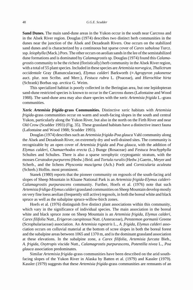
Xeric Artemisia frigida-grass Communities. Distinctive xeric habitats with Artemisiafrigida-grass communities occur on warm and south-facing slopes in the south and centralYukon, particularly along the Yukon River, but also in the north on the Firth River and nearOld Crow (Scudder 1993) (Fig. 35). These grassland habitats have a distinctive insect fauna(Lafontaine and Wood 1988; Scudder 1993).
Douglas (1974) describes such an Artemisia frigida-Poa glauca Vahl community alongthe Alsek and Dezadeash River, on extremely dry and well-drained sites. The community isrecognizable by an open cover of Artemisia frigida and Poa glauca, with the addition ofElymus calderi, Chamaerhodos erecta (L.) Bunge (Rosaceae) and Festuca brachyphyllaSchultes and Schultes. There is also a sparse xerophytic cryptogamic stratum, with themosses Ceratodon purpurens (Hedw.) Brid. and Tortula ruralis (Hedw.) Gaertn., Meyer andScherb., and the lichens Physconia muscigena (Ach.) Poelt and Cornicularia aculeata(Schreb.) Hoffm. most prominent.
Stanek (1980) reports that the pioneer community on regosols of the south-facing aridslopes of Sheep Mountain in Kluane National Park is an Artemisia frigida-Elymus calderi-Calamagrostis purpurascens community. Further, Hoefs et al. (1976) note that suchArtemisia fridiga-Elymus calderi grassland communities on Sheep Mountain develop mostlyon very fine loess aeolian (frequently still active) regosols, in both the boreal white and blackspruce as well as the subalpine spruce-willow-birch zones.
Hoefs et al. (1976) distinguish five distinct plant associations within this community,which vary in the significance of individual species. The main association in the borealwhite and black spruce zone on Sheep Mountain is an Artemisia frigida, Elymus calderi,Carex filifolia Nutt., Erigeron caespitosus Nutt. (Asteraceae), Penstemon gormanii Greene(Scrophulariaceae) association. An Artemisia rupestris L., A. frigida, Elymus calderi asso-ciation occurs on colluvial material at the bottom of scree slopes in both the boreal forestand the subalpine areas between 1065 and 1370 m, and is the dominant grassland associationat these elevations. In the subalpine zone, a Carex filifolia, Artemisia furcata Bieb.,A. frigida, Oxytropis viscida Nutt., Calamagrostis purpurascens, Potentilla nivea L., Poaglauca association predominates.
Similar Artemisia frigida-grass communities have been described on the arid south-facing slopes of the Yukon River in Alaska by Batten et al. (1979) and Kassler (1979).Kassler (1979) suggests that these Artemisia frigida-grass communities are remnants of an
48 G.G.E. Scudder
earlier late Pleistocene arctic steppe ecosystem. Whether this arid steppe-like communitydominated Beringia in the late Pleistocene as claimed by Guthrie (1985, 1990), and is nowrepresentative of an extinct biome (Matthews 1976), or instead is a remnant of an earliertundra-steppe mosaic (Ager 1982, 1983), or an upland xeric tundra (Schweger 1982), thereis no doubt that this is a unique and special habitat in the Yukon. It contains a number ofrare plant species (Batten et al. 1979), many grassland insects with southern affinities(Scudder 1993), and Pleistocene refugial endemic insects (Anderson 1984).
FIG. 35. Known occurrence of xeric Artemisia frigida in the Yukon (redrawn after Cody 1996): major roads are alsoshown.
Environment of the Yukon 49
Similar relics of the xerophytic vegetation of Beringia occur in northeastern Asia(Yurtsev 1982). It is certain that the Artemisia frigida-grass communities on warm, aridsouth-facing slopes are among the most interesting and notable habitats in the Yukon.
Ecogeographic Regions, Ecozones and Ecoregions of the YukonThe various physiographic areas of the Yukon, together with their associated climate
and vegetation, are major reference points for understanding and interpreting the distributionof the biota. Oswald and Senyk (1977) identified 22 ecoregions in the Yukon, areas of landwhere the vegetation, soils and permafrost reflect the regional climate.
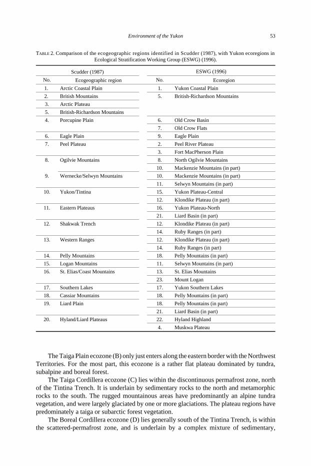
In 1987, I used the Oswald and Senyk (1977) ecoregion scheme, combined withBostock’s (1948) physiographic divisions of the Yukon, to produce a map of 20 eco-geographic regions that could be used in the description and analysis of the distribution ofthe different insect groups in the Territory. This map (Fig. 36) is reproduced herein, becausemany authors in the Insects of the Yukon have referred to it in their individual chapters.
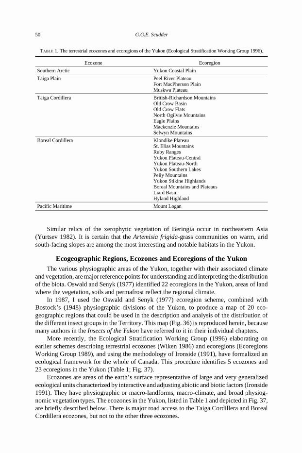
More recently, the Ecological Stratification Working Group (1996) elaborating onearlier schemes describing terrestrial ecozones (Wiken 1986) and ecoregions (EcoregionsWorking Group 1989), and using the methodology of Ironside (1991), have formalized anecological framework for the whole of Canada. This procedure identifies 5 ecozones and23 ecoregions in the Yukon (Table 1; Fig. 37).
Ecozones are areas of the earth’s surface representative of large and very generalizedecological units characterized by interactive and adjusting abiotic and biotic factors (Ironside1991). They have physiographic or macro-landforms, macro-climate, and broad physiog-nomic vegetation types. The ecozones in the Yukon, listed in Table 1 and depicted in Fig. 37,are briefly described below. There is major road access to the Taiga Cordillera and BorealCordillera ecozones, but not to the other three ecozones.
TABLE 1. The terrestrial ecozones and ecoregions of the Yukon (Ecological Stratification Working Group 1996).
Ecozone Ecoregion
Southern Arctic Yukon Coastal Plain
Taiga Plain Peel River PlateauFort MacPherson PlainMuskwa Plateau
Taiga Cordillera British-Richardson MountainsOld Crow BasinOld Crow FlatsNorth Ogilvie MountainsEagle PlainsMackenzie MountainsSelwyn Mountains
Boreal Cordillera Klondike PlateauSt. Elias MountainsRuby RangesYukon Plateau-CentralYukon Plateau-NorthYukon Southern LakesPelly MountainsYukon Stikine HighlandsBoreal Mountains and PlateausLiard BasinHyland Highland
Pacific Maritime Mount Logan
50 G.G.E. Scudder
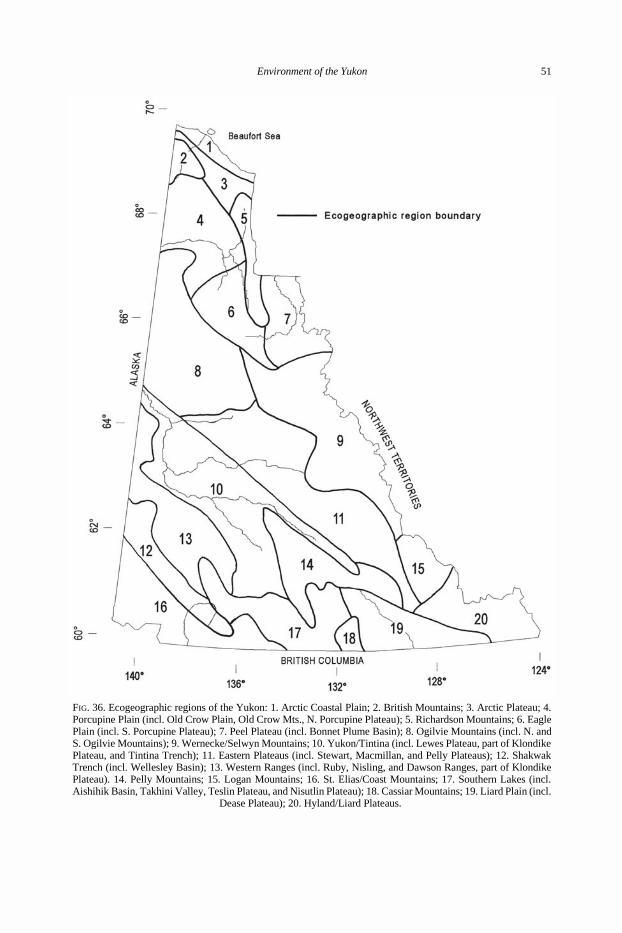
FIG. 36. Ecogeographic regions of the Yukon: 1. Arctic Coastal Plain; 2. British Mountains; 3. Arctic Plateau; 4.Porcupine Plain (incl. Old Crow Plain, Old Crow Mts., N. Porcupine Plateau); 5. Richardson Mountains; 6. EaglePlain (incl. S. Porcupine Plateau); 7. Peel Plateau (incl. Bonnet Plume Basin); 8. Ogilvie Mountains (incl. N. andS. Ogilvie Mountains); 9. Wernecke/Selwyn Mountains; 10. Yukon/Tintina (incl. Lewes Plateau, part of KlondikePlateau, and Tintina Trench); 11. Eastern Plateaus (incl. Stewart, Macmillan, and Pelly Plateaus); 12. ShakwakTrench (incl. Wellesley Basin); 13. Western Ranges (incl. Ruby, Nisling, and Dawson Ranges, part of KlondikePlateau). 14. Pelly Mountains; 15. Logan Mountains; 16. St. Elias/Coast Mountains; 17. Southern Lakes (incl.Aishihik Basin, Takhini Valley, Teslin Plateau, and Nisutlin Plateau); 18. Cassiar Mountains; 19. Liard Plain (incl.
Dease Plateau); 20. Hyland/Liard Plateaus.
Environment of the Yukon 51
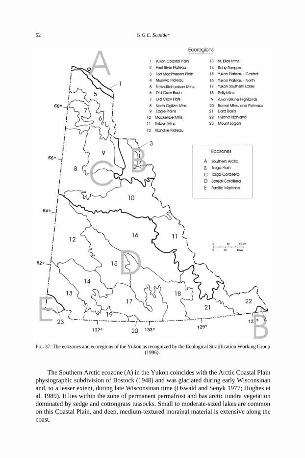
The Southern Arctic ecozone (A) in the Yukon coincides with the Arctic Coastal Plainphysiographic subdivision of Bostock (1948) and was glaciated during early Wisconsinanand, to a lesser extent, during late Wisconsinan time (Oswald and Senyk 1977; Hughes etal. 1989). It lies within the zone of permanent permafrost and has arctic tundra vegetationdominated by sedge and cottongrass tussocks. Small to moderate-sized lakes are commonon this Coastal Plain, and deep, medium-textured morainal material is extensive along thecoast.
FIG. 37. The ecozones and ecoregions of the Yukon as recognized by the Ecological Stratification Working Group(1996).
52 G.G.E. Scudder
The Taiga Plain ecozone (B) only just enters along the eastern border with the NorthwestTerritories. For the most part, this ecozone is a rather flat plateau dominated by tundra,subalpine and boreal forest.
The Taiga Cordillera ecozone (C) lies within the discontinuous permafrost zone, northof the Tintina Trench. It is underlain by sedimentary rocks to the north and metamorphicrocks to the south. The rugged mountainous areas have predominantly an alpine tundravegetation, and were largely glaciated by one or more glaciations. The plateau regions havepredominately a taiga or subarctic forest vegetation.
The Boreal Cordillera ecozone (D) lies generally south of the Tintina Trench, is withinthe scattered-permafrost zone, and is underlain by a complex mixture of sedimentary,
TABLE 2. Comparison of the ecogeographic regions identified in Scudder (1987), with Yukon ecoregions inEcological Stratification Working Group (ESWG) (1996).
Scudder (1987) ESWG (1996)
No. Ecogeographic region No. Ecoregion
1. Arctic Coastal Plain 1. Yukon Coastal Plain
2. British Mountains 5. British-Richardson Mountains
3. Arctic Plateau
5. British-Richardson Mountains
4. Porcupine Plain 6. Old Crow Basin
7. Old Crow Flats
6. Eagle Plain 9. Eagle Plain
7. Peel Plateau 2. Peel River Plateau
3. Fort MacPherson Plain
8. Ogilvie Mountains 8. North Ogilvie Mountains
10. Mackenzie Mountains (in part)
9. Wernecke/Selwyn Mountains 10. Mackenzie Mountains (in part)
11. Selwyn Mountains (in part)
10. Yukon/Tintina 15. Yukon Plateau-Central
12. Klondike Plateau (in part)
11. Eastern Plateaus 16. Yukon Plateau-North
21. Liard Basin (in part)
12. Shakwak Trench 12. Klondike Plateau (in part)
14. Ruby Ranges (in part)
13. Western Ranges 12. Klondike Plateau (in part)
14. Ruby Ranges (in part)
14. Pelly Mountains 18. Pelly Mountains (in part)
15. Logan Mountains 11. Selwyn Mountains (in part)
16. St. Elias/Coast Mountains 13. St. Elias Mountains
23. Mount Logan
17. Southern Lakes 17. Yukon Southern Lakes
18. Cassiar Mountains 18. Pelly Mountains (in part)
19. Liard Plain 18. Pelly Mountains (in part)
21. Liard Basin (in part)
20. Hyland/Liard Plateaus 22. Hyland Highland
4. Muskwa Plateau
Environment of the Yukon 53
volcanic, intrusive and metamorphic bedrock. Most of the ecozone lies within the Yukondrainage system, and has predominantly boreal white and black spruce forest, subalpinespruce-willow-birch, and alpine tundra at the higher elevations.
The Pacific Maritime ecozone (E) is the extensive wet ecozone of the Pacific coast thatjust reaches into the southwestern corner of the Yukon. The ecozone is predominantly veryhigh-elevation ice fields, alpine glaciers and summit outcrops. There is no terrestrialvegetation or soil development in this region.
Ecoregions are subdivisions of the ecozones, characterized by distinctive large orderlandforms or assemblages of regional landforms, small order macro- or mesoclimates, andvegetational assemblages. The 23 ecoregions in the Yukon listed in Table 1 and mapped inFig. 37 are described by the Ecological Stratification Working Group (1996). Table 2provides comparisons of these ecoregions with the ecogeographic regions identified inScudder (1987).
The Yukon in Summary
The general environmental features of the Yukon show it to be a relatively cold, rugged,and mountainous area, much of which is covered by relatively sparse or stunted vegetation,including arctic and alpine tundra, and subalpine and open subarctic forests. Nevertheless,the Yukon has relatively rich river valleys and substantial areas in the south with a surprisingdiversity of subtypes of forest and other vegetation. Moreover, several specific insecthabitats, such as warm, south-facing slopes, have particular interest in the context of currentfaunal diversity and faunal history.
During the Pleistocene much of the Yukon remained ice-free and was part of Beringia,the largest refugial area in the north during the last ice age. As such, the Yukon is a centralfocus of biogeography in the Nearctic region.
Acknowledgements
Research for this paper was supported by grants from the National Research Council ofCanada. I am indebted to D.A. Demarchi (B.C. MELP), D. Russell (Canadian WildlifeService, Whitehorse) and S. Smith (Agriculture and Agri-Food Canada, Whitehorse) forproviding information and maps. R.A. Cannings and S.G. Cannings kindly provided land-scape photographs. I thank L. Lucas for preparing the various illustrations and text.
ReferencesAger, T.A. 1982. Vegetational history of western Alaska during the Wisconsinan glacial interval and the Holocene.
pp. 75 – 93 in D.M. Hopkins, J.V. Matthews Jr., C.E. Schweger, and S.B. Young (Eds.), Paleoecology ofBeringia. Academic Press, New York. 489 pp.
______ 1983. Holocene vegetational history of Alaska. pp. 128 –141 in H.J. Wright (Ed.), Late-QuaternaryEnvironments of the United States. Vol. 2. The Holocene. Univ. Minnesota Press, Minneapolis. 277 pp.
Agriculture Canada Expert Committee on Soil Survey. 1987. The Canadian System of Soil Classification. 2ndedition. Res. Brch Agric. Can. Publ. 1646. 164 pp.
Anderson, R.S. 1984. Connatichela artimisiae, a new genus and species of weevil from the Yukon Territory(Coleoptera: Curculionidae: Leptopiinae): Taxonomy, paleontology, and biogeography. Can. Ent. 116:1571 –1580.
Batten, A.R., D.F. Murray, and J.C. Dawe. 1979. Threatened and Endangered Plants in Selected Areas of the BLMFortymile Planning Unit, Alaska. U.S. Department of the Interior BLM-Alaska Technical Report 3. 127 pp.
Bonnor, G.M. and E.T. Oswald. 1989. The Yukon Forest Reconnaissance Inventory 1985. Forestry Canada, Pacificand Yukon Region Information Report BC-X-315. 30 pp.
Bostock, H.S. 1948. Physiography of the Canadian Cordillera, with Special Reference to the Area North of theFifty-fifth Parallel. Geol. Surv. Can. Mem. 247. 106 pp.
54 G.G.E. Scudder
______ 1961. Physiography and resources of the Yukon. Can. Geogr. J. 63:112 –119.______ 1966. Notes on Glaciation in Central Yukon Territory. Geol. Surv. Can. Pap. 65 -36. 18 pp.______ 1970. Physiographic subdivisions of Canada. pp. 9 – 30 in R.J.W. Douglas (Ed.), Geology and Economic
Minerals of Canada. Department of Energy, Mines and Resources, Canada. Economic Geology Report No. 1.838 pp.
Brown, R.J.E. 1970. Permafrost in Canada. Its Influence on Northern Development. Univ. Toronto Press, Toronto.234 pp.
______ 1978. Permafrost. Plate 32 in Hydrological atlas of Canada. Canadian National Committee for theInternational Hydrological Decade, Ministry of Supply and Services, Ottawa.
Clague, J.J. 1989a. Bedrock geology (Canadian Cordillera). pp. 22 – 25 in R.J. Fulton (Ed.), Quaternary Geologyof Canada and Greenland. Geological Survey of Canada, Ottawa. 839 pp.
______ 1989b. Cordilleran ice sheet. pp. 40 – 42 in R.J. Fulton (Ed.), Quaternary Geology of Canada and Greenland.Geological Survey of Canada, Ottawa. 839 pp.
______ 1989c. Relationships of Cordilleran and Laurentide glaciers. pp. 42 – 43 in R.J. Fulton (Ed.), QuaternaryGeology of Canada and Greenland. Geological Survey of Canada, Ottawa. 839 pp.
Danks, H.V. and D.M. Rosenberg. 1987. Aquatic insects of peatlands and marshes in Canada: synthesis ofinformation and identification of needs for research. pp. 163 –174 in D.M. Rosenberg and H.V. Danks (Eds.),Aquatic Insects of Peatlands and Marshes in Canada. Mem. ent. Soc. Can. 140. 174 pp.
Danks, H.V. and D.D. Williams. 1991. Arthropods of springs, with particular reference to Canada: synthesis andneeds for research. pp. 203 – 217 in D.D. Williams and H.V. Danks (Eds.), Arthropods of Springs, withParticular Reference to Canada. Mem. ent. Soc. Can. 155. 217 pp.
Delcourt, P.A. and H.R. Delcourt. 1987. Long-term Forest Dynamics of the Temperate Zone. A Case Study ofLate-Quaternary Forests in Eastern North America. Springer-Verlag, New York, Berlin, Heidelberg. 439 pp.
Douglas, G.W. 1974. Montane zone vegetation of the Alsek River region, southwestern Yukon. Can. J. Bot.52:2505 – 2532.
Downes, J.A. and D.H. Kavanaugh (Eds.). 1988. Origins of the North American Insect Fauna. Mem. ent. Soc. Can.144. 168 pp.
Ecological Stratification Working Group. 1996. A national ecological framework for Canada. Agriculture andAgri-Food Canada, Research Branch, Centre for Land and Biological Resource Research and EnvironmentCanada, State of the Environment Directorate, Ecozone Analysis Branch, Ottawa/Hull. 125 pp. and map at1:7 500 000 scale. [“1995”]
Ecoregions Working Group. 1989. Ecoclimatic Regions of Canada, First Approximation. Ecoregions WorkingGroup of the Canada Committee on Ecological Land Classification. Ecological Land Classification Series,No. 23. Sustainable Development Branch, Canadian Wildlife Service, Conservation and Protection, Environ-ment Canada, Ottawa. 119 pp. and map at 1:7 500 00.
Foster, W.A. and J.E. Treherne. 1976. Insects of marine saltmarshes: problems and adaptations. pp. 5 – 42 in L.Cheng (Ed.), Marine Insects. North-Holland Publishing Co., Amsterdam, Oxford. 581 pp.
French, H.M. and J.A. Heginbottom (Eds.). 1983. Guidebook to Permafrost and Related Features of the NorthernYukon Territory and Mackenzie Delta, Canada. Division of Geological and Geophysical Surveys, Departmentof Natural Resources, State of Alaska, Fairbanks. 186 pp.
Gabrielse, H. and C.J. Yorath (Eds.). 1992. Geology of the Cordilleran Orogen in Canada. Geological Survey ofCanada, Ottawa. 844 pp.
Guthrie, R.D. 1985. Woolly arguments against the mammoth steppe—a new look at the palynological data. Q. Rev.Archaeol. 6:9 –16.
______ 1990. Frozen Fauna of the Mammoth Steppe: The Story of Blue Babe. Univ. Chicago Press, Chicago andLondon. 323 pp.
Hamilton, T.D. and R.M. Thorson. 1983. The Cordilleran ice sheet in Alaska. pp. 38 – 52 in S.C. Porter (Ed.),Late-Quaternary Environments of the United States. Vol. 1. The Late Pleistocene. Univ. Minnesota Press,Minneapolis. 407 pp.
Heusser, C.J. 1983. Vegetational history of the northwestern United States including Alaska. pp. 239 – 258 inS.C. Porter (Ed.), Late-Quaternary Environments of the United States. Vol. 1. The Late Pleistocene. Univ.Minnesota Press, Minneapolis. 407 pp.
Hoefs, M., I. McT. Cowan, and V.J. Krajina. 1976. Phytosociological analysis and synthesis of Sheep Mountain,southwest Yukon Territory, Canada. Syesis 8 (Supplement 1) (1975):125 – 228.
Hopkins, D.M. (Ed.). 1967. The Bering Land Bridge. Stanford Univ. Press, Stanford. 495 pp.Hopkins, D.M., J.V. Matthews Jr., C.E. Schweger, and S.B. Young (Eds.). 1982. Paleoecology of Beringia.
Academic Press, New York. 489 pp.Hughes, O.L. 1972. Surficial Geology of Northern Yukon Territory and Northwestern District of Mackenzie,
Northwest Territories. Geol. Surv. Can. Pap. 69-36. 11 pp.Hughes, O.L., R.B. Campbell, J.E. Muller, and J.O. Wheeler. 1969. Glacial Limits and Flow Patterns, Yukon
Territory, South of 65 Degrees North Latitude. Geol. Surv. Can. Pap. 68-34. 9 pp.Hughes, O.L., N.W. Rutter, and J.J. Clague. 1989. Yukon Territory (Quaternary stratigraphy and history, Cordil-
leran Ice Sheet). pp. 58 – 61 in R.J. Fulton (Ed.), Quaternary Geology of Canada and Greenland. GeologicalSurvey of Canada, Ottawa. 839 pp.
Environment of the Yukon 55
Hughes, O.L., R.O. van Everdingen, and C. Tarnocai. 1983. Regional setting-physiography and geology. pp. 5 – 34in H.M. French and J.A. Heginbottom (Eds.), Guidebook to Permafrost and Related Features of the NorthernYukon Territory and Mackenzie Delta, Canada. Division of Geological and Geophysical Surveys, Departmentof Natural Resources, State of Alaska, Fairbanks. 186 pp.
Ironside, G.R. 1991. Ecological land survey: Background and general approach. in H.A. Stelfox, G.R. Ironside,and J.L. Kansas (Eds.), Guidelines for the Integration of Wildlife and Habitat Evaluations with EcologicalLand Survey. Wildlife Habitat Canada and Canadian Wildlife Service, Environment Canada, Ottawa. 107 pp.
Judge, A.S. 1973. Deep temperature observation in the Canadian North. Permafrost: North American contributionto the Second International Conference on Permafrost, Yakutsk, Siberia, July 1973:35 – 40.
Kassler, K.C. 1979. Relicts of the Late Pleistocene arctic-steppe: investigations of certain south-facing slopes ininterior Alaska. B.A. thesis, Middlebury College. 70 pp.
Kojima, S. and R.C. Brooke. 1986. An Annotated Vascular Flora of Areas Adjacent to the Dempster Highway,Central Yukon Territory. I. Pteridophyta, Gymnospermae and Monocotyledonae. Br. Columb. Prov. Mus.Contribs Nat. Sci. 3(1985). 816 pp.
Krajina, V.J. 1975. Some observations on the three biogeoclimatic zones in British Columbia, Yukon andMacKenzie District. Phytocoenologia 2:396 – 400.
Lafontaine, J.D. and D.M. Wood. 1988. A zoogeographic analysis of the Noctuidae (Lepidoptera) of Beringia, andsome inferences about past Beringian habitats. pp. 109 –123 in J.A. Downes and D.H. Kavanaugh (Eds.),Origins of the North American Insect Fauna. Mem. ent. Soc. Can. 144. 168 pp.
Lindsey, C.C., K. Patalas, R.A. Bodaly, and C.P. Archibald. 1981. Glaciation and the physical, chemical andbiological limnology of Yukon lakes. Can. Tech. Rep. Fish. aquat. Sci. 966. 37 pp.
Matthews, J.V., Jr. 1976. Arctic-steppe - an extinct biome. AMQUA Abstracts 4:73 – 77.Matthews, J.V., Jr., and A. Telka. 1997. Insect fossils from the Yukon. pp. 911 – 963 in H.V. Danks and J.A. Downes
(Eds.), Insects of the Yukon. Biological Survey of Canada (Terrestrial Arthropods), Ottawa.Meidinger, D. and J. Pojar. 1991. Ecosystems of British Columbia. British Columbia Ministry of Forests, Victoria,
B.C. 330 pp.Mickelson, D.M., L. Clayton, D.S. Fullerton, and H.W. Borns Jr. 1983. The late Wisconsin glacial record of the
Laurentice ice sheet in the United States. pp. 3 – 37 in S.C. Porter (Ed.), Late-Quaternary Environments of theUnited States. Vol. 1. The Late Pleistocene. Univ. Minnesota Press, Minneapolis. 407 pp.
Natural Wetlands Working Group. 1988. Canada Wetland Regions in Wetlands of Canada. Sustainable Develop-ment Branch, Environment Canada. Ecological Land Classification Series, No. 24.
Oswald, E.T. and B.N. Brown. 1986. Forest Communities in Lake Laberge Ecoregion, Yukon Territory. CanadianForestry Service, Pacific Forestry Centre Information Report BC-X-282. 97 pp.
______ 1990. Vegetation Establishment During 5 Years Following Wildfire in Northern British Columbia andSouthern Yukon Territory. Forestry Canada, Pacific and Yukon Region Information Report BC-X-320. 46 pp.
Oswald, E.T. and J.P. Senyk. 1977. Ecoregions of Yukon Territory. Fisheries and Environment Canada, CanadianForestry Service, Pacific Forest Research Centre Information Report BC-X-164. 115 pp.
Porter, S.C., K.L. Pierce, and T.D. Hamilton. 1983. Late Wisconsin mountain glaciation in the Western UnitedStates. pp. 71 –111 in S.C. Porter (Ed.), Late-Quaternary Environments of the United States. Vol. 1. The LatePleistocene. Univ. Minnesota Press, Minneapolis. 407 pp.
Prest, V.K. 1970. Quaternary geology of Canada pp. 675 – 764 in R.J.W. Douglas (Ed.), Geology and EconomicMinerals of Canada. Department of Energy, Mines and Resources, Canada. Economic Geology Report No. 1.838 pp.
Rampton, V.N. 1982. Quaternary Geology of the Yukon Coastal Plain. Geol. Surv. Can. Bull. 317. 49 pp.Ritchie, J.C. 1982. The modern and Late-Quaternary vegetation of the Doll Creek area, North Yukon, Canada. New
Phytol. 90:563 – 603.______ 1984. Past and Present Vegetation of the Far Northwest of Canada. Univ. Toronto Press, Toronto, Buffalo,
London. 251 pp.Ryder, J.M. 1983. Surficial geology of the grassland areas of British Columbia and adjacent regions. pp. 63 – 87 in
A.C. Nicholson, A. McLean, and T.E. Baker (Eds.), Grassland Ecology and Classification. SymposiumProceedings. B.C. Ministry of Forests, Victoria, B.C. 353 pp.
Schweger, C.E. 1982. Late Pleistocene vegetation of Eastern Beringia: Pollen analysis of dated alluvium.pp. 95 –112 in D.M. Hopkins, J.V. Matthews Jr., C.E. Schweger, and S.B. Young (Eds.), Paleoecology ofBeringia. Academic Press, New York. 489 pp.
______ 1989. Paleoecology of the western Canadian ice-free corridor. pp. 491 – 498 in R.J. Fulton (Ed.), QuaternaryGeology of Canada and Greenland. Geological Survey of Canada, Ottawa. 839 pp.
______ 1997. Late Quaternary palaeoecology of the Yukon: a review. pp. 59 – 72 in H.V. Danks and J.A. Downes(Eds.), Insects of the Yukon. Biological Survey of Canada (Terrestrial Arthropods), Ottawa.
Scudder, G.G.E. 1969. The fauna of saline lakes on the Fraser Plateau in British Columbia. Verh. int. Verein. theor.angew. Limnol. 17:430 – 439.
______ 1976. Water-boatmen of saline waters (Hemiptera: Corixidae). pp. 263 – 289 in L. Cheng (Ed.), Marineinsects. North-Holland Publishing Co., Amsterdam, Oxford. 581 pp.
______ 1979. Present patterns in the fauna and flora of Canada. pp. 87 –179 in H.V. Danks (Ed.), Canada and ItsInsect Fauna. Mem. ent. Soc. Can. 108. 573 pp.
56 G.G.E. Scudder
______ 1987. Ecogeographic regions of the Yukon. Map and Key. 2 pp. (unpublished).______ 1993. Geographic distribution and biogeography of representative species of xeric grassland-adapted
Nearctic Lygaeidae in western North America (Insecta: Heteroptera). pp. 75 –113 in G.E. Ball and H.V. Danks(Eds.), Systematics and Entomology: Diversity, Distribution, Adaptation, and Application. Mem. ent. Soc.Can. 165. 272 pp.
Shaw, J. and R.H. Stobbart. 1963. Osmotic and ionic regulation in insects. Adv. Insect Physiol. 1:315 – 399.Souther, J.G. and E.C. Halstead. 1969. Mineral and thermal waters of Canada. Proceedings of Symposium II, 23rd
International Geology Congress. Academia, Prague: 225 – 256.Stanek, W. 1980. Vegetation Types and Environmental Factors Associated with Foothills Gas Pipeline Route,
Yukon Territory (Maps and Legend). Canadian Forestry Service, Pacific Forest Research Centre InformationReport BC-X-205. 48 pp.
Stanek, W., K. Alexander, and C.S. Simmons. 1981. Reconnaissance of Vegetation and Soils along the DempsterHighway, Yukon Territory: I. Vegetation Types. Canadian Forestry Service, Pacific Forest Research CentreInformation Report BC-X-217. 32 pp.
Stanek, W. and L. Orloci. 1987. Some Silvicultural Ecosystems in the Yukon. Canadian Forestry Service, PacificForest Research Centre Information Report BC-X-293. 56 pp.
Tarnocai, C., I.M. Kettles, and M. Ballard. 1995. Peatlands of Canada. Geological Survey of Canada. Open File3152.
Tarnocai, C., C.A.S. Smith, and C.A. Fox. 1993. International Tour of Permafrost Affected Soils. The Yukon andNorthwest Territories of Canada. Centre for Land and Biological Resources Research, Research Branch,Agriculture Canada, Ottawa. 197 pp.
Wahl, H.E., D.B. Fraser, R.C. Harvey, and J.B. Maxwell. 1987. Climate of Yukon. Climatological Studies Number40. Atmospheric Environment Service, Environment Canada. 233 pp.
Waitt, R.B., Jr., and R.M. Thorson. 1983. The Cordilleran ice sheet in Washington, Idaho and Montana. pp. 53 – 70in S.C. Porter (Ed.), Late-Quaternary Environments of the United States. Vol. 1. The Late Pleistocene. Univ.Minnesota Press, Minneapolis. 407 pp.
White, M.P., C.A.S. Smith, D. Koretsch, and K. McKenna (Compilers). 1992. Soil Landscapes of Canada YukonTerritory. Maps 1 page. Centre for Land and Biological Resource Research Contribution No. 89-05.
Wiken, E.B. (compiler). 1986. Terrestrial Ecozones of Canada. Ecological Land Classification Series No. 19.Environment Canada, Hull. 26 pp. and map.
Wiken, E.B., D.M. Welch, G.R. Ironside, and D.G. Taylor. 1981. The Northern Yukon: An Ecological Land Survey.Environment Canada, Lands Directorate, Ecological Land Classification Series No. 6. 197 pp.
Yurtsev, B.A. 1982. Relics of the xerophytic vegetation of Beringia in northeastern Asia, pp. 157 –177 inD.M. Hopkins, J.V. Matthews Jr., C.E. Schweger, and S.B. Young (Eds.), Paleoecology of Beringia.Academic Press, New York. 489 pp.
Zoltai, S.C. 1975. Tree ring record of soil movement on permafrost. Arct. Alp. Res. 7:331 – 340. ______ 1987. Peatlands and marshes in the wetland regions of Canada. pp. 5 –13 in D.M. Rosenberg and H.V. Danks
(Eds.), Aquatic Insects of Peatlands and Marshes in Canada. Mem. ent. Soc. Can. 140. 174 pp.Zoltai, S.C. and C. Tarnocai. 1974. Soils and Vegetation of Hummocky Terrain. Environmental Social Program
Task Force on Northern Oil Development Report 74 -5. 86 pp.Zoltai, S.C., C. Tarnocai, and W.W. Pettapiece. 1978. Age of cryoturbated organic materials in earth hummocks
from the Canadian arctic. 3rd International Conference on Permafrost, Edmonton 1978. National ResearchCouncil of Canada, Ottawa. 1:325 – 331.
Environment of the Yukon 57